Showing posts with label Scotland's long walking trails. Show all posts

Wednesday, 27 August 2025

A Pilgrim ramble.....St Ninians Cave

Walk: St Ninians's Cave


This short ramble was inspired by the Pilgrims walk from Glasgow to Whithorn but this is certainly not the full walk, only a very, very short section, the final mile or so. A recent visit to the Govan Stones and a chat with the staff kicked it off. Many pilgrims past and present would have visited the Govan site en route. Well worth visiting.

I was in the area for a break with the good lady site who was happy with a short walk to visit this historic place.

Scotland has so much history of all kinds and on my rambles I enjoy stopping and immersing myself in locations and try to imagine the sounds, sights, smells etc. of that history.

St Ninians Cave has been documented as a place of worship and healing back to the 8th century. St Ninian is reputed to be the 1st Saint in Scotland, 397AD. That's a huge wow for me. The Latinus Stone on display at the Priory is the oldest surviving Christian memorial.

The ramble will be narrated mainly via the snaps.

Well sign posted

Despite the time of year the birds were still singing in this lovely wooded section

Out of the woods there are options


But we continued straight on down Physgill Glen where the water soon came into view. Despite it being summer the weather was cool, the water was gunmetal grey rather than Mediterranean blue but this is Scotland.

Colourful flora such as this Campion all around the path as we walked down

Evidence of geological upheaval 


A true shingle beach to cross to wards the cave seen ahead. Not much different to what the 8th century pilgrims would have seen

How smooth are these?

A recent podcast suggested that rocks with this quartz strata lining had a good chance of containing a fossil. Same podcast examined rocks from Nairn area and found some minerals had only be found in rocks in Estonia. Considering they started being formed sub equator they have travelled a long way.

Just reflect on the exact spot and cave entrance, those early travellers all stood here. The interior has collapsed so only the entrance is clear, although danger of rockfall signs around.

Not quite sure she is a pilgrim!

Free Sea Kale for your foraging diet

Rock Pipit

Trail back that away

The season is coming to an end

So an excellent short ramble. For those a lot more adventurous the walk can be comfortable extended by doing a circuit from Whithorn or including some of the way marked coastal paths.
Time to relax, some mead would be appropriate.

Sunday, 4 August 2024

Finally Scotland's most iconic long distance pass.....Lairig Ghru

Walk: Lairig Ghru (Forbidden or gloomy pass)


This has been on my must do list for as long as I have been interested in hillwalking but the logistics never seemed to come together. It is probably the most best known mountain pass in Scotland and probably Britain. This is a vast area with the walk splitting huge mountains, the slopes of 3 of the 4 highest in Scotland included. Ralph Storer says ‘Its scale has to be seen to be appreciated. For grandeur and variety of scenery it is without equal’. Fully endorsed.

This year I decided it was now or never and that I would do it solo, starting in Braemar and staying in Aviemore afterwards or getting the good lady to drive me back. But when doing my research I came across a firm called Hillgoers who started the direction I wanted to go from at the Braemar side but more importantly had a mini bus to run you back to Braemar. Sorted, some company and a lift, well worth the money. The walk has no escape routes if the weather turns bad or an accident happens, all adds to the pre-walk tension. Walking from this direction means a gentler but longer ascent to the high pointat the Pools of Dee.

I had cadged a lift to the start at Linn of Dee. Bumped into Ben Dolphin and reminisced about a walk we did together when he was Ramblers president.

The weather was to be warmer than I would have liked, well laden with liquid but as I found out there were some streams to fill up en route. A motley crew we were, introductions made and off we went.
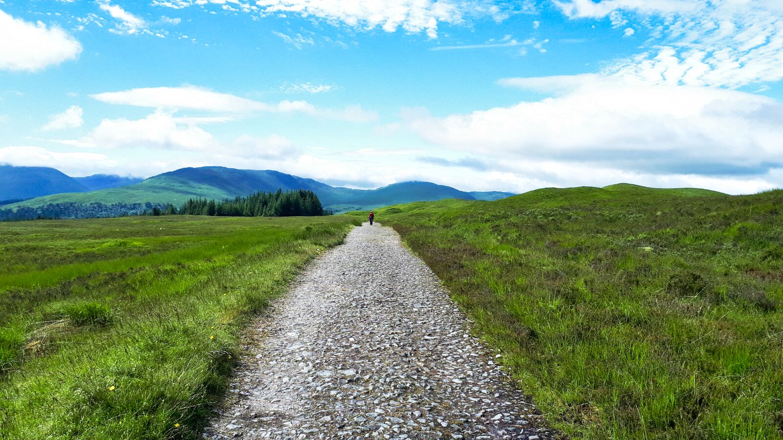


I had walked the start section before with ADRC when we did the Munro of Carn a’Mhaim. Initially it seemed different I think because we visited the river to see the falls, before memory returned when we rejoined the main track to the abandoned Derry Lodge. Glen Luibeg & Glen Lui alongside Scots Pine, moor and bubbling streams. Really weird I said aloud that I would have expected to hear a cuckoo today and in less than 10 seconds one started calling. We all burst out laughing, as it turned out the only one heard today.

All went well until we reached the river crossing which was running quite high. The group split a couple crossing whilst the rest of us walked up to the bridge crossing adding an extra kilometer or more walking in the already hot day.

I was first across the bridge to be greeted by a very attractive young lady skinny dipping. When she realised a party was coming through it was a quick exit to put on knickers and a top, her partner just smiled and shrugged his shoulders.


Bypassing the Munro we were now on the Lairig proper. We wound our way round the mountain track until Corrour Bothy came into view. Located below the Devils Penis (Point) it has an impressive backdrop but your eye is also aware of the long trail heading along Glen Dee towards the giant slopes of Cairn Toul on the left and Ben Macdui on the right, as rugged terrain as you will get any where in Scotland. The eye is led by that trail winding ahead but there is also the knowledge of what is round the corner, still only about a third into the walk.

I had no illusions regarding the roughness of the terrain on the so called path but even so it surprised me. It was full on concentration to avoid tripping and sadly at times the views were ignored as the path was the focus and indeed that remained so for most of the walk. When we stopped and looked around it was ruggedly breathtaking. There are constant rock landslips to remind you that this is an active landscape. Indeed at one point we heard a noise and looked up and a large boulder was rolling down a patch of snow leaving a firm trail, it was a heavy one.

Porridge corrie

An Garbe Choire

The area of the one of the great corries, An Garbe Choire (The rough corrie) and spectacularly rough it is, still quite a bit of snow around. ‘Porridge’ corrie is equally impressive. Some cattle fell from the top through a cornice and smashed up quite a bit hence the name.

The watershed at this spot is where the falls come down off Braeriach and Macdui and is as impressive as the corrie. Although the Dee’s source starts on the Braeriach plateau many regard this as the start as it is also joined by the water from the Pools of Dee. A good spot to pour water over my head and refill. It was very humid but at times a strong chilling breeze blew into our backs, nice relief and better than blowing in your face.

Boulder field beckons

Then the boulder field(s) came into view. We chatted with the occasional walker(s) that we met before this and they all called the boulder field long and arduous. Our guide

George said it was 5 minutes. The reality was much nearer George's view as indeed there is a track which makes it easier, not easy, but with hindsight is probably easy to lose if coming from the north thus enduring a much longer and harder boulder field crossing. There are possibly 3 different sections of boulders but our first is the most awkward if that track is missed.


There are 3 or 4 Pools of Dee, some vibrant green, a contrast to the stony slopes and a beautiful spot to take another short break.

Lurchers gully now showing impressively to the right in distance. I had in my mind this was much closer to the finish, walk ending soon, no chance.


Lurchers Gully

Still 3 hours to go but now downhill all the way

Then we reached the highest point of the Lairig with views of Aviemore beyond. The views forward and back, superb. Checked the GPS and we have covered exactly 20km. It might be all downhill from here but it is still at least another 10km, more as it turned out. Another 3 hours of walking.

It was a weird day as I tripped twice on the descent from here, nothing hurt other than pride. Tiredness, lack of concentration I don't know but it happened.


As it turned out it was 3 hours from that cairn and although the Caledonian pine Forrest is unique and grand viewing, particularly on the higher descent, the truth is that we just wanted the walk over. The chatter had reduced, a good pace was being kept. The Cairngorm Club footbridge was a welcome sight, finally getting there.

Another part of the weird day was I cannot remember that last time I had a blister. But twice I had to remove stones and grit from my right boot and with about 1km to go I knew I had a bad blister forming, it was very sore. So stopped and Compeed applied to try to minimise the damage but it did not really improve, it was a slow painful hobble back to Coylumbridge.

Another part of the weird day was I cannot remember that last time I had a blister. But twice I had to remove stones and grit from my right boot and with about 1km to go I knew I had a bad blister forming, it was very sore. So stopped and Compeed applied to try to minimise the damage but it did not really improve, it was a slow painful hobble back to Coylumbridge.

No doubt that this was an incredible day out with outstanding views and exceeded my expectations. But it was also a very demanding long walk, very hard on the feet, testing my physical and mental capacity.

Ambition achieved, glad I did it but a repeat, I don't think so, at least not in the short term.

Ascent: 811m

Distance: 32.9km

Time: 10.21

Wildlife: Meadow pipit; Willow warbler; Common Sandpiper; Ring Ouzel (heard); Cuckoo (heard)


Saturday, 10 December 2022

WHW Inveroran - Glencoe Ski Centre

Walk: West Highland Way

Section: Inveroran - Kingshouse

After yesterdays wash out at least it was dry this morning, even though the temperature was still low and the clouds well down. So what to do with the good lady? She felt up to a small section of the West highland Way, fine with me. 

Inveroran Hotel
Off we drove to our start at Inveroran Hotel, a historic inn dating back to early 1700's. No chance of coffee and scone as yet another place that has a sign up 'only catering to residents'. I wonder what our visitors think of this as it is now so common? The next opportunity to buy food is just under 10 miles away. It really is not good enough for an area dependant on tourism and on a National walking route.


This is a straight forward section of the WHW, even the good lady could not get lost or so I thought. 'Where do we go now' was heard early on. The Black Mount Munros were covered in cloud but breaks give a glimpse into the magnificent corrie.


The road structure can be clearly seen
After the tarmac road to Forrest Lodge the route became more interesting as we were walking on a historic drovers route which was made into a harder foundation as a Parliamentary Road by Thomas Telford. We passed a small derelict quarry where I presumed the stones came from. I could imagine the navvies breaking up the rocks with their hammers, very hard graft. There are the deep depressions on either side of the road, pushed down from the weight of the many carriages of various types over the years. Trees on the other side prevented us getting any sighting of the Black Mount lodge, a private dwelling I think. At least the trees kept the wind at bay.

Good lady heads back to the car

Whilst I keep going
Then it was out into the open moor. This is one of the most exposed sections of the WHW. Today it was fine but yesterday it would have been awful. After an hour of walking the good lady turned back and I hopefully I will meet up with her at the end.

As I walked I was looking at a couple of hills when it clicked that they are a pair of Sub2k's I did last year. Different perspective is why I did not recognise them at first.

Munro Meall a' Bhuiridh comes into view

Rannoch Moor starts here
Not a lot to say about this section, grass and moor with some Glencoe corries and tops to provide interest. It is however, the start of the famous Rannoch moor. I passed a few walkers almost all foreign from the voices, most smiling. 

In the distance I saw this long moving line, my eyesight is not great but even I could tell it was a large human convoy coming my way. When I met up they were sitting on either side of the Ba bridge, most head down, no youngsters and from the few voices I heard a group of Germans. They didn't look the fittest bunch and probably will be even less happy when they reached the hotel 'residents only' at Inveroran if they were hoping for refreshments!! 

Munro of Creise just poking out behind Bhuiridh

Clouds now into Coire an Easain 
I had now completed the highest section, my last small piece of Turkish Delight the reward, before turning and contouring towards Glencoe. The wind was now stronger and colder and the clouds seemed even lower. My hopes of a clear view of the Buachaille dashed. It was there but with an atmospheric cloud covering sadly. At least I have seen these views before. It would have been nicer for the 1st timers behind me to see it in all its glory.

Stob Dearg but hidden in its shroud today
Then the good lady was spotted, not quite dashing to meet up me, more huddled in layers desperate to get to the ski centre café for warmth and cake. Thankfully it was open!

I walked the route faster than most would so that I caught up with the good lady before she panicked. It meant that I did get a slight sweat on despite the coolness. Overall it was a good short ramble to finish what has been a less than inspiring start to the summer.

Ascent: 332m

Distance: 13.8km

Time: 2.59

Wildlife: Raven; Chaffinch; Blue Tit; Meadow Pipit; Pearl Bordered Fritillary; Large White;

Thursday, 10 November 2022

WHW.....Crianlarich - Tyndrum

Walk: West Highland Way

Section: Crianlarich - Tyndrum


Woke up to the sound of rain battering the window, not exactly what I wanted to hear. The forecast was to be grim all morning, high winds all day so no high tops today.

As the afternoon was for showers, I decided to get the train to Crianlarich and walk back to Tyndrum via the West Highland Way. Short train journey, but it was packed and humid, the chances of Covid?

As always, the hard bit is finding the start. Crianlarich is a fair bit off the official WHW according to my map. I headed down to the Post Office where I found a tourist map/board. Back up to the station and follow the Drovers Loop which should connect to the WHW. Good but where is this trail at the station. Turns out you go through a tunnel, head up a flight of steps and there is a marker. 

I did not have a map and had not looked at the route beforehand, so I was surprised at how much elevation is gained so quickly and how high above the road the track goes. Still plenty of peace and quiet, only bumped into two people until Dalrigh area.

After a lung bursting ascent from Crianlarich this is what greets you

Typical scenery

I love the moss on top of the rock, a small croft!!

Spotted this unusual plant, Heath Speedwell my app says


Hill middle right one of the Corbetts that was Plan A
There has been much deforestation, but I suppose it does open up the views. Up and down the track goes. I spotted movement on a tree branch, quickly disappearing. I was certain it was not a squirrel which only left a Pine Martin, if so, that would have been my first ever sighting but not conclusive enough.


River in full flow

Just one reason for this being an amazing country
Out of the woods and across the road to the ancient historical ruins at the Fillan's priory and graveyard. As I was looking about the farmer drove into his yard with a trailer. All hell let loose. I assume it was a bull and the noise it was making it was far from happy. I made a quick movement to get through the farmyard gate.

A pleasant stroll then back across the road again for the the final few miles to Tyndrum. I spoke to a Swedish woman with her three daughters. The youngest one looked at her mother and said, 'this is so beautiful'. Despite the poor weather it was a reminder to remember what we have in Scotland.

So, an afternoon of showers and very high wind gusts. When I reached Tyndrum it was just too cold in that wind. But remember the wee girl, no complaining. On a cold day the reward had to be a fish supper at the Real Food Cafe. A good ramble.

Ascent: 391m

Distance: 12.2km

Time: 2.52

Wildlife: Coal Tit; Chaffinch; Blackbird; Swallow; Sand Martin;