Monday, 23 December 2024

Borders Sub2k raid Hill 1.....Sell Moor Hill

Hill: Sell Moor Hill

Type: Sub2k

Height: 423m

Another visit to the lovely Lammermuir Hills. If you want to make this a proper outing then start from either Stow or Lauder and it becomes at least a half day outing. The hill is the high point between the two towns. 


However I was just ticking the box so I started from the normal bagging layby at the standing stone which starts the walk at over 300m.

When I left home it was -2 with clear blue skies. That was the forecast for here as well so I was more than a little surprised at the change to the cloudy grey skies as I neared the start. At least the clouds lifted the temperature to a comfortable 8degrees.

From the layby I crossed the road and headed up through the damp rough/reedy ground heading for the edge of the trees.


At the tree junction an electrified and barbed wire fence had to be crossed twice, thankfully it was in disrepair. 


Decision time re which side to go before heading up the right hand side of the dyke towards another tree plantation. It looked easier going. The only sound was the call of a pheasant hiding in the reeds in the other field.

For some reason, lack of preparation, I thought that the trig was in the trees but it was obvious that the grassy mound on my right was higher than the forest. An easy decision to head over the rough ground until I went over a hump and spotted the trig.

Looking south to the Eildons

West towards Peebles
Although it was a grey day there were some decent views, particularly over to the Eildons.

Easy going straight back


Moles have been busy

Realising I had time on my hands I decided to pick off one of the hills I had earmarked for tomorrow so I did not dawdle and returned by the same route.

An unremarkable hill but it does get me another blue balloon.

Ascent: 88m

Distance: 2.4km

Time: .44

Wildlife: Pheasant (m), Crow

Sunday, 22 December 2024

A grey day for a ramble to.....Craig of Monievreckie

Hill: Craig of Monievreckie

Type: Sub2k

Height: 400m

I had this wee one on my ‘local hills’ Winter programme, ideally for a good weather straightforward midweek solo ramble but the other day I spotted that one of my walking groups had added it to its programme so opted for company rather than a solo ramble.

This is a typical Sub2k, not a lot of height, not a lot of distance, but the rugged terrain makes sure it is not a Sunday walk in the park.

We met up in Aberfoyle which used to be my main go to place when getting the mountain bikes some mileage, alongside Jamie where he learnt his bike handling skills. Good memories but a long time ago.

Unfortunately the weather was grim this morning, rain, very low cloud creating misty conditions, fingers crossed that it would improve.

Glad not going up through that stuff

Rob Roy Way
From Aberfoyle car park we headed up into the forest to meet up with the Rob Roy Way. A straightforward forest track for a mile or so before a sharp left turn where we left the Rob Roy Way. Still on the track but gaining height quicker now. Well used by mountain bikers as a few passed us.

Turn off at the top of this shot

The cut off into the trees proper is very easy to miss. For a short section it is a steep narrow track through the trees. The track is wet with muddy and slippery stones and tree roots.

After that it is out onto the misty open countryside where the narrow trail is still steep but not surrounded by dying bracken.

We clambered up the rough path to reach the small hill at point 393m only 7 metres lower than the main top. Still limited visibility so although The Craig was not far away it could not be seen.

We also had a steep drop of about 50m on a very muddy twisty thin streak of something that might just be called a track. At times it was so slippy that walking in the heather was the better option when possible.

Trig comes into view

More impressive cairn marks the highpoint, just after the trig
Finally back up the height of the drop plus 7 metres! A trig appeared out of the mist and the summit of Monievreckie was reached. It was also bloody cold, so much for a change of weather. Apparently there are excellent views from here but it is Scotland so views definitely not guaranteed.

We retraced our steps back down the 57m but instead of climbing back up to point 393 we decided to circle the hill back to our ascent track.

Rough ground that's more like it

Ascent path found

We had about 15mins of very rough ground, head high bracken and lots of hidden burns ready to trap a leg. The mist was even starting to lift. This is more like proper Sub2k terrain. Rubbish ground but a bit of fun as well.

Uphill path re-joined we headed back down the slippery track. As the weather was better we decided to head up the track to the Ariel mast which is a renowned viewpoint.

Aberfoyle down left corner, Craigmore comes into sight

Ben Venue starts to show itself

When we reached it there was still a lot of mist around but within minutes it started to break up. Perfect timing and atmospheric snaps. This is what we hoped for.

On the descent we took an early wrong turn but rather than walk all the way back we found an MTB trail which linked us back to the original route and back to Aberfoyle.

Overall it ended up being a successful day out. Another wee hill bagged, good company both new and old and the views to finish.

Ascent: 545m

Distance: 12.6km

Time: 4.27

Wildlife:

Friday, 20 December 2024

The good lady's type walk.....Port Appin to Clach Thoull

 Walk: Port Appin to Clach Thoull (Hole in the Rock)


View across Loch Linnhe to Kingairloch, beyond the bright blue sky day!

The weather forecast was for clear blue skies all day and it might have been for some as you can see in the snap but not for us!!

After our very misty short hill walk we came back to sea level and drove along the single track road the delightful small hamlet of Port Appin. I had hoped to visit this spot earlier in the year to get the ferry over to Lismore and cycle the island. The good lady was with me today so that was not an option. Instead the short circular walk to Clach Thoull was more her idea of fun.

Despite the lingering low cloud slightly higher it was lovely at sea level.


Ferry pier on right and Lismore on left
The walk starts behind the hotel walking past some nice houses and steep tree lined crags, then soon coming across a viewpoint area. Three different information boards and superb views over to Lismore and beyond. People were standing on the jetty, presumably waiting for the ferry, a lovely spot to spend some time.


Great Northern Diver

On the calm waters we potted a couple of Great Northern Divers, many cormorants and shags all regularly diving for their lunch.


Canada Geese

The sound of silence was rudely interrupted by the loud honking of geese. Around 20 were flying low across the water but then they kept coming in waves, I reckoned about 200 in total.

Walking on the trees were full of the normal suspects, Robins, Blackbirds and Thrushes.


Clach Thoull

Next stop was the first of two natural sea arches, this one named as Clach Thoull, both of which you can walk through. It was interesting to reflect on all the current climate discussions that at one time the sea level was clearly higher than it is just now for the crashing sea waters to have cut out these arches.


Lynn of Lorn


Cormorant

We took the short track through the bracken to the point of the headland, another tranquil spot with great views. On the near rocks a Grey Heron stood hunched and motionless, probably already fed. A Great Black Backed Gull on the further rocks and a Grey Seal’s snout and head showed briefly.


Walking back a great shot of how trees grow straight out of granite rock, no soil structure, quite amazing.


2nd arch, tried to get away but she found me

We rounded the headland and walked through the second arch with plenty of birds around. Airds Bay was at low tide but had very few birds on the mudflats today.


Then a short but beautiful woodland walk, amazing autumn colours still hanging on here. Birch, Oak, Hawthorn, Ash, Rowan, Holly & Sycamore, quite a mix.


Finally back to Port Appin and the unusual lighthouse lantern full of local information boards, a local historical exhibition. Some were hard to read because of condensation so a wee winter restoration project for some locals perhaps.

Overall a delightful short ramble in a beautiful part of the country and a large and varied amount of birds for a short ramble.

Ascent: 43m

Distance: 2.49km

Time: 1.01

Wildlife: Grey Seal; Canada Geese; Buzzard; Great Black Backed Gull; Hooded Crow; Herring Gull; Coal Tit; Blackbird; Robin; Redpoll’ Redwing; Dunlin; Goldfinch; Chaffinch;


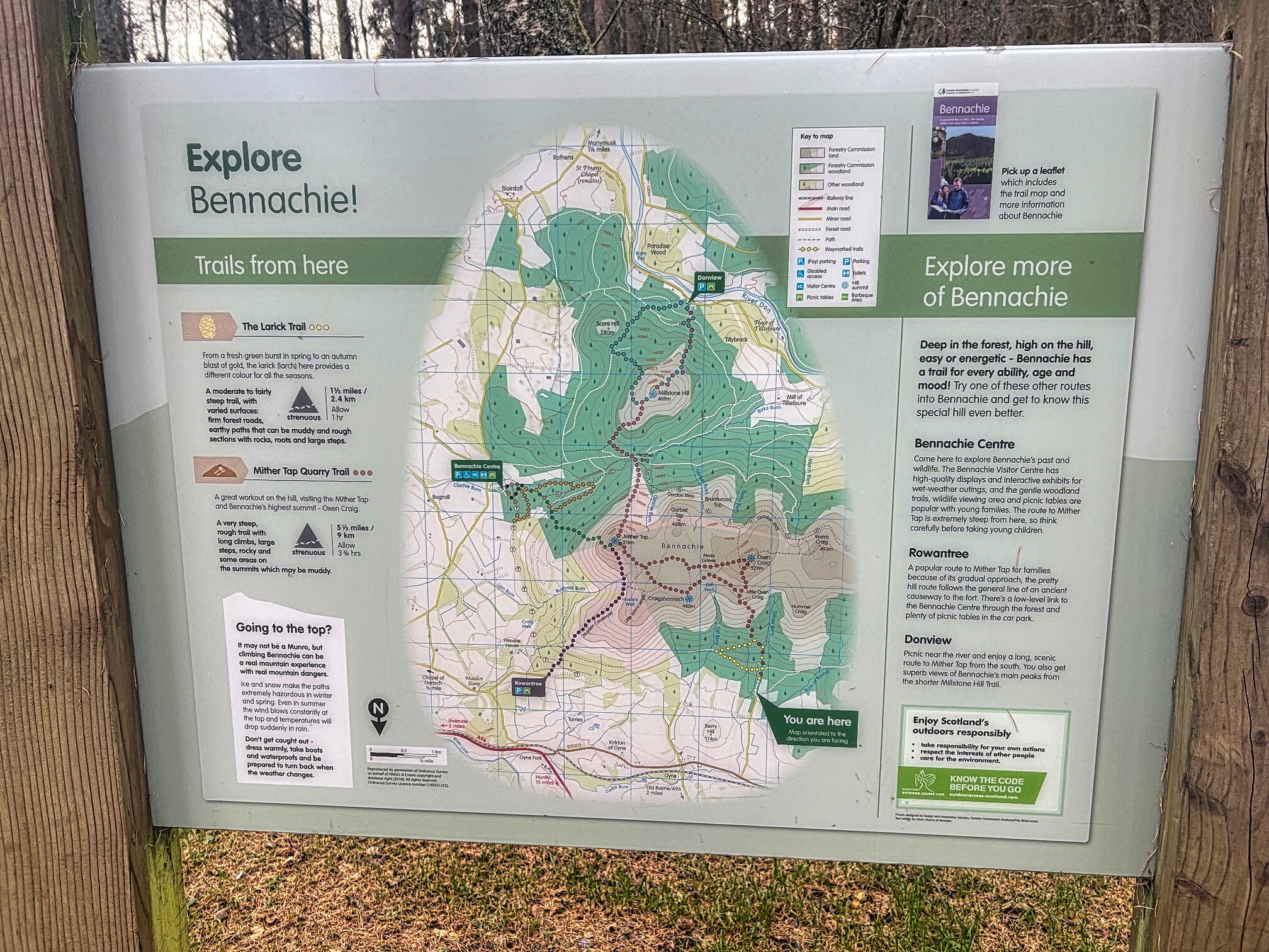
Wild and windy on a Pictish hillfort tour.....Bennachie

Hill: Bennachie (The hill of the nipple or pap)

Type: Sub2k

Height: 528m


Plan A had been to tick off the Fiona of Hunt Hill but the weather forecast had changed big style since yesterday. Although the air quality was to be excellent the winds were forecast as exceptionally strong. Indeed the MWIS forecast for the Eastern Munro summits was ‘Impossible to walk’, I have seen all sorts described but never seen impossible on a clear day, but take heed I must.

Plan B was to visit this renowned Pictish hill fort circuit. For some reason on Walkhighlands it is named as Bennachie after the range of hills, but there are two hills to visit, neither named Bennachie and only one of them is a Sub2k, despite just 10m of height difference, very odd and more later. This circuit has been on my to-do list for a few years so it was a good opportunity to get it done.


I parked up at the large parking area situated in a pine forest called Back O Bennachie. Well laid out with a toilet block but of course you have to pay. It was a reasonable charge at £2.50 for 3 hours or £3 all day. The all day was the one I needed. Usual problem the machine would not move on from coin only payment to accept a card but luckily I had £2.50 in change in the car. Not really enough but would I be back in time or get fined for 50p?

As I changed the light breeze was gently shaking the tree tops and the pine needles were dropping down slowly, just like snowflakes. By the time I headed off I was covered in orange needles.

As Bennachie is Aberdeen's high ground play area it is popular and well laid out with a myriad of trails. Everything is well signposted so no excuse for getting lost. 


Hopefully that does not get blown down the track

As I climbed through the initial tree section it was another reminder of how much damage Storm Arwen caused a few years back. Despite a lot of tree cutting much more remains to be done to fully open up all the trails around here.

Just before I exited the treeline the wind was much stronger and the trees were swaying and noisy. Out of the relative tree shelter warmer gear was required, a sign of what lay ahead.


The two peaks in the distance are Little Conval & Meikle Conval at Dufftown

I followed a very well constructed dirt path with many stone sections. A short detour took me to the first viewpoint at the quarry, Little Oxen Craig, wind gusts were already very strong.

Oxen Craig

Larger peak on right is Ben Rinnes

Oxen Craig viewfinder looking to Mither Tap

Then back on the track where I kept climbing to Oxen Craig, the true Sub2k. However, the final metres were difficult, the wind was very strong and gusty. When I reached the viewpoint pillar I had to hold onto it to take in the views. As the forecast said excellent long distance views, pity it wasn't a day to enjoy them.

Brief stop before dropping off Oxen and taking the good track to the second hill, Mither Tap, the site of the Pictish fort.

Mither Tap left or right?

When I dropped down the wind had eased and for about 15mins the going was fine. As Mither Tap neared I could see a track on either side. I opted for the left side thinking it was on the sheltered side but not to be. The wind and gusts were far stronger than Oxen, making even normal walking tough going.
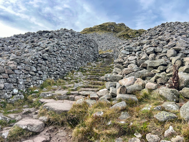
Best remains of a Pictish hillfort entrance that I have visited

Apologies but the sign was in very poor condition

As I neared the top and the path petered out. I looked up at the top from this angle, the top about 20 metres higher, but in-between a steep boulder field needed ascending. I was not risking it in these winds. This is a tourist hill so there must be an easier way I muttered to myself. I crabbed over some crappy stuff, trying to keep my balance and found the real ascent track on the other side which went up through the amazing remains of the Iron Age fort. There is a well constructed winding stone stepped staircase to the top which in good conditions would be no problem for most.  But it is exposed and I was very careful as a strong gust meant a dangerous fall.

Sitting beside the trig to avoid getting blown away and try to get a snap without the shakes

On the top of Mither Tap the winds were the strongest of the day. So much so that I crouched my way to the two structures, the trig and the viewpoint. Holding on for dear life I took in the vista. It is truly a superb viewpoint justifying a fortress being built here.

I was even more careful on the descent from the top, some bum sliding to avoid the gusts and with relief reached the big stone shelter. 

A skein of 50+ geese appeared struggling to make ground flying into these winds, find a field to rest I yelled, they ignored me.

Although the paths are well constructed the strong winds were blowing fragments of grit into my eyes, no goggles of course.

Descending from Mither Tap that is Oxen Craig but I was contouring towards the trees

I followed the route to Craigshannoch but passed on another top and contoured the heather to re-join the ascent track and back to the car.

Another objective achieved, just a pity that wind was so strong.

Ascent: 488m

Distance: 9.6km

Time: 2.46

Wildlife: Blue Tit; Pink Footed Geese