Sunday 29 October 2017

Carlin's Cairn

What a difference a week makes, last Sunday grey, sodden, just miserable. Today the 1st blue skies for goodness knows how long. The clocks changed, potential extra hour in bed, but I wakened with my normal sleeping pattern so up, drove the 45 miles to the Forrest Lodge car park and was walking just before 9am.
My objective was Carlin’s Cairn, a Donald at 807m. This would complete the Rhinns of Kell summits for me. To get there I chose to ascend via the Corbett, Corserine 814m.
As soon as I left the car park there were two deer were feeding on the edge of the forest, nice early morning sight.
The walk in
Head north towards forest lodge then go left (west) up the forest track named Birger Natvig road to pass the house at Fore Bush. The ridge looks particularly good in the morning sun.
Basically just keep following the track and you cannot go wrong.
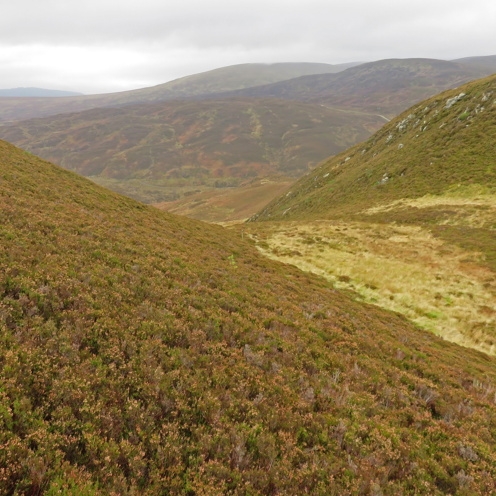
Turn left here
After 1.97 miles from start the track swings right at NX525874. Take to the track on the left and after 200m or so follow a path off left into the forest on the south side of the Folk Burn, which is crossed across a new mud bridge after a few hundred metres. 
This half mile walk is extremely wet and boggy with few options other than keep jumping from side to side to try avoid deep mud puddles.
Open moor follow the path
Once it emerges from the forest cross the stile onto open moorland and into a nice bowl shaped area. A fairly clear path, but wet and slippy at times, the path continues west onto Craigrine, the NE ridge of Corserine, which is climbed to the summit plateau. The sun was beating down and I was perspiring, is it summer? 
Almost at plateau
Once on top there is a very large cairn, which can be seen from near the start but this is not the highest point. 
Carlin's cairn behind this cairn
Follow the faint path and if like today the trig of Corserine is clearly seen along with great views north of Carlin's Cairn along with the other hills in the north ridge. The south ridge were in bright sunlight so no snaps. 
Merrick from Corserine
Walk has taken 1h 50min from start, good progress, but up here the northerly winds were now giving me the fridge treatment so on went hat and gloves. 
I take a few minutes as the views are superb but this was not my destination so on I went. 
Carlin's Cairn from Corserine
Carlins cairn lies to the north (it is only 7 metres smaller than Corserine). Follow another track and there is a drop of about 100 metres before climbing back up to the large cairn. Of course I had to do it the other way as well and I was feeling my legs by the time I was back up top on Corserine. 
The extra ascent was worth it as the views from here were today better than Corserine. 2hrs 15min to cairn. Just take it all in. I spotted someone at the trig but they didn’t come this way, the only other person so far. Brilliant views of ‘The Range of the Awful Hand’ and Loch Enoch.
Awful Hand from Carlin's
The return has fine views of Polmaddy Gairy corrie (I love the names here), care required from the top if misty. Unfortunately the views on one side are dominated by wind turbines so enjoy the other views. 
On the descent from Corserine it was also care required as the wet grass was very slippy indeed.
Forrest Lodge Black Watch
I actually met some other people coming up so not all alone on the hills after all.
When I finished I had a look at the Forrest Lodge and its history. Belonging to the Fred Olsen liner this handsome Black Watch has a very interesting history but I will leave you to search for it.
A very good walk and particularly nice to see the blue skies.


Time: 4 hours 17min
Distance: 9.6m (15.45km)
Ascent: 2844ft (867m)

Monday 23 October 2017

Hill of Stake and aptly named Misty Law

Back to a group day with the guys n gals from KRC. The plan was a long moorland trek taking in Hill of Stake 522m (Marilyn/Sub 2000), the highest point in Renfrewshire followed by Misty Law. I read a few walking reports and almost all describe it as a boggy mud fest, they were not wrong.
Typical moor at the bottom but at least some trees
Storm Brian was meant to have passed through yesterday but sitting at the car park you would not have guessed it as the wind buffeted the car along with the accompanying rain. According to the mountain forecast website it was to be windy but dry, nope.
Narrowly avoided a roe deer running under the car on the way here. I was 1st to arrive and sat in the car thinking they wont be coming, wait 10 minutes and home again but nutters they are and arrive they did.
I left the camera in car, could not afford another rain destroyed one so all snaps are from my phone.
Wet track its a bleak place
Some of the group had been on a map and compass training recently, they would get to practice all their new found learning today.
Approaching bothy
The walk follows the mine track from Muirshiel car park for just over 2 miles in heavy rain and strong winds. Imagine working out here, no electricity, hard graft indeed. We had an early short tea break in the bothy/hut as that would be the last shelter of the day.
Hard graft
After refreshments the climb started properly across the rough moorland, no more paths. I don’t think that I have had a day where I walked in a water plain for so long. Every footstep was into sphagnum moss totally immersed and holding plenty of water. The moor was saturated, a real sponge and there were quite a few hidden hazards. At one point my right leg went in so deep to a hidden mudhole that only my other leg hitting the ground stopped me, my poles kept me upright. I still could not feel hard ground below my foot!! Not a place to be on your own today.
Burn in spate
Small burns that are normally an easy step across were now raging rivers, not quite, but very awkward to cross at times.
Hill of Stake trig

We crossed the moor to the old fence line, the boundary between Ayrshire and Renfrewshire and followed that up to Hill of Stake trig point. 2hours 20min to this point.
Up there I think?
We kept going via East Girt hill until we reached a newly constructed barbed wire fence, totally blocking the faint track, excellent thinking by the constructor, not, so it was a difficult climb over this for some.
Misty Law
Until we reached the top of Misty Law (510m) we were shrouded in mist so there had been no views at all, sometimes difficult to see the front walker if you were at the rear, along with the constant driving rain and high winds, not great. Why do we do this? Castle Semple and Lochwinnoch in sight, the waters looking blue, probably not had rain there.
Where is that rock?
As we began our descent the weather eased slightly, giving us some longer views but as we crossed this moor, views were put to one side, the terrain worsened, no paths at all, not even sheep trails, hard walking.
We only had one more burn to cross and it was in full flow so an awkward step onto a submerged boulder and then jump. All of the group made it without falling in but it was close for some. A bit of excitement to end the day.
Mountain goats final climb
One more climb then the trees surrounding the car park were spotted the end in sight. We now could see Glasgow in the distance.
Finish in sight
If I had been on my own in these conditions I would have turned back. As it was we were all very wet but the humour was excellent and the company as always made the day.
I will have to return to see the views but I will be picking the next day carefully, an excellent viewing day only and drier underfoot.

Time: 5hrs 36m
Distance: 8.28mls (13.33km)
Ascent: 1447ft (441m)

Wednesday 18 October 2017

Dun Coilliche wee hill at the heart of Scotland

View from parking area
The kids were arriving at lunchtime so looked for a short morning hill and came up with the Marilyn, Dun Coillich 572m. 
The hill within an interesting community purchase with a view to recreating the land to its original habitat, it is worth an internet search and reading.
Walking map
Having read the previous reports on Walkhighlands I was intending to follow the same route but by chance I missed the 1st Dun Coillich entrance so turned in at the next one, the one with the Portaloo. Here there are a few items including a direction board which indicated a marked route all the way around Dun Coillich with a spur heading to the summit. But after fighting my way through unmarked undergrowth the burn was running too fast, I suspected more than a wet bum if I attempted crossing here, so time for a rethink.
I jumped in the car and drove the short distance to park at the caravan park at Glengoulandie.
I crossed the burn at the wooden bridge immediately before the deer centre entrance. No obvious access the hill. Spoke to a local who pointed out an overgrown track on the right immediately after crossing the bridge.
Infrequently used path
A 100m or so walk along the bank to a kissing gate, it was a tight squeeze, either it’s narrow or I need to lose weight.
I could see another fence some way ahead across extremely marshy ground. Tried sticking to higher areas but feet were in water/bog well above ankles at times. Sprung about a dozen partridge. Next there was a sizeable fence to climb to bring me to open moorland.
Got to climb this
I had picked a line from the start going to the left of the trees and then going upwards and across to the summit from there. Trudging through the heather and ferns I thought that this was going to be a long trudge for a short hill. A pair of buzzards cried as they circled above.
Found the track
However, a bit of luck, I stumbled across the marked green/white posts. Basically this is following the route into Gleann Mor which you get good views of as you climb Schiehallion.
The going is pretty good a wet grass track and my only decision is whether to cut off and head upwards through the heather or hope for the spur. I continue on the still wet but ok trail and reach a post that appears to be set slightly back. I can see the main trail but decide to follow this faint trail into the heather and ferns. The OS map confirmed this would be ok.
Spur track
However, it doesn’t help when looking for green posts in this landscape if you suffer from a version of green/red colour blindness.
Eventually I spotted another post so on the right line. The climb basically follows semi hidden burns which you can hear babbling away but often don’t see. Walking was a cautious affair, constantly prodding the sticks but still there were a few times the foot went down hidden holes. It was glorious isolation but not the place to sprain an ankle or worse.
As I climbed movement to my right a beautiful stag stood looking at me. His colouring was so dark he blended perfectly with the heather. A couple of bounds and he disappeared over a ridge never to be seen again.
Summit in sight
When you finally crest the ridge you can continue to the next post which takes you past the summit or simply head up through the heather on the right until you spot the small cairn. Top reached 52 minutes.
Summit cairn looking towards Loch Tummel
A trio of ravens showing off their ariel acrobatics, does that mean anything if your supersticious?
All the higher hilltops are covered in cloud but the local views are still fine, particularly Gleann Mor, the path of Schiehallion clearly seen, Loch Kinardochy.
Schiehallion path clearly seen
I take some time to wander about the tops enjoying the scenery but I still have take care as now deep moss alongside the heather. 
View on descent
I decide to drop back into the glen just as a pair of buzzards fly past then a third appears, but no much bigger wings, I spend about 5 minutes watching the eagle circle above the buzzards before away into the clouds it went.
On the way down red grouse, pheasant and stonechat sighted, not bad.
Followed the trail and back over the marshy ground to the car.
A good walk that fully met the objective.

Distance; 2.75m (4.43km)
Ascent: 945ft (288m)
Time: 1.53


Monday 16 October 2017

Newtyle Hill

Newtyle Hill
Well, that was a fair bit of effort just to complete this small hill. My one tip to anyone contemplating this route is do it in the winter or spring before the undergrowth flourishes. Although I enjoyed my walk overall I can’t say that I enjoyed the final section, more to follow.
The weather forecast of fog to low levels around Dalwhinnie, along with high winds and rain, changed my plans for today, instead I opted for Newtyle Hill, a sub 2000 at all of 317m so should be fog free.
The winds were battering the static van all night, I thought the big storm not due for 24 hours, clearly wrong. Still after a good roll of Lorne slice from MacDonald's the butcher I was ready to go. They do cut a large slice of sausage, same goes for the well hung ribeye for my dinner tonight.
River Tay from Dunkeld Newtyle hill behind
Arrived at Dunkeld early on a Sunday morning and the place was rammed with cars, no obvious spaces to be see, where to park? Eventually I drive back over the bridge to Little Dunkeld and just stopped in the road, no warning signs. There also seemed to be an awful lot of cyclists around considering the weather forecast but as I was to find out on my hill, an MTB enduro event with over 300 participants was on today, hence no easy parking.
Still at this stage it was a pleasant enough morning as I wandered back over the bridge, no salmon leaping, and waited a moment or two to try and get a bit of sunlight on the island in the Tay. Then into Dunkeld and a quick right took me up the steep brae, that got the breathing going. Some lovely properties around and a communal garden area to keep the community spirit high.
Go left here
I followed the tarmac road until I came across the signs for the Loch of the Lowes trail, turn left and follow this and before long reach the egg hutch with an honesty box. 

I was intending to buy some but it was  empty of eggs, no free range scrambled eggs tomorrow. There was money inside so just too late, probably all those bikers got them.
A pleasant forest walk, trees and ferns going orange, leads you to a big gate, the workers route to the transmitter ariel. The other track is the lower level loch walk. Go through the side gate and follow this track up the hill.
Autumn colours
At the first bend, on your left, there is a stile crossing the deer fence. Feel free if you are a masochist, if the terrain is similar to the last section is anything to go by good luck. I continued up the track and reached the next fence at the deforested war zone terrain.
Deforistation ahead
Now that I am out of tree cover and onto the exposed area the wind gusts are significant, the rain is getting stronger and Birnham hill has just disappeared in the gloom. It is however very warm and I change my heavier shell top to a lighter Gore-Tex jacket.
Left or nothing
At the junction there is no option other than to follow the zig-zag trail as the bike route is taped off and a very obvious yellow sign. As I walk the trail I realise that there are a lot of bike tracks so I am staying alert for a fast descending MTB. I am also aware of hearing the odd voice on the wind, close or far.
A flash of blue is spotted in the undergrowth, it is a race marshall, cold and wet. We have a chat, the bike racers are coming this way, over 300 of them. 
Pushing uphill
I continue towards the starting hut mentioned in a previous report and am now being passed by quite a few bikers , more of them walking than cycling which surprised me or maybe not it is a long way up to cycle. It then transpires when chatting to some that the only timed section is the downhill run.
I reach the hut mentioned in a previous report and walk on looking for the stile, no track now and going through some pretty heavy undergrowth, a machete would have been helpful, this can't be right. 
This does not look or feel right
The rain is hosing down so the phone out and the online OS map briefly examined. I retrace my steps and it transpires I must have misread the report as there is a stile before the hut not after, probably missed it as too busy looking out for bikers.
1st style
I attempted to follow the brick wall which has a new deer fence alongside but the undergrowth is pretty hard going. Deforested tree debris are well hidden in the large heather growth. Ferns at chest height to negotiate and new trees are blocking the obvious walking. I keep the wall as close as feasible, the wind and rain also combining to hinder, this is unpleasant. After my previous camera malfunctioned/died after getting wet via the zoom lens retracting back into the dry body, my new one was now firmly in a dry bag, hidden away so no more snaps today.
I found and clambered across the last style with difficulty, using the wire fence more than I should have. Not as robust as the previous one. Using a previous report on the phone I kept going (life without 4g?), without it I probably would have just turned back. Using their snaps I got to the small cairn and no hanging about to fight my way back through that stuff.
River Tay & Dunkeld
Back on the track it was now constant bikers of all ages, sexes and sizes. Apparently this was only one of 6 stages today, a very tough day indeed. I got so immersed with them that I continued down a trail that I did not realise was there to finish up at the main road, now with a longer tarmac walk back to Dunkeld. There were many areas to stop and watch the bikers fly through. I also MTB but this was a skill set up for me, particularly as I watched a few painful looking crashes.
Still an enjoyable day, the rain was now off. Wildlife barren as the weather except some bullfinches, a good few months since I last saw one. Don’t think that I will be rushing to return to this hill.
Looks like hurricane Ophelia will be altering my last two planned days as well, the joys of Scotland.

Distance: 5.84 miles (9.40km)
Ascent: 1076ft (328m)
Time: 2 hr 48min 

Blath Bhalg Hill of the rutting stags

According to the SMC book this hill translates as ‘pleasant bulge’. As we know, Gaelic is such a atmospheric and descriptive language, that I was unsure about my expectations for this walk. I suppose it depends on where you are looking at the hill from but my route was as per the book, I had quite a few bulges, pleasant or not, an individuals call.
However, this is not a negative review, far from it, I had a superb walk and I would rename it ’hill of the stag’. The timing of the red deer rut not coincidental.
I had driven north this morning and wanted a leg stretcher within my tight timeframe. Just off the A9 and on the Pitlochry-Blairgowrie road was the Graham, Blath Bhalg, 641m in height but a lot less in actual walking.
The Start
Easy to find the start, two aerials stand proud either side of the parking area. Actually, when getting out of the car the northerly wind was chilling, a combination of now no car heater and the real wind chill temperature. Seasons are progressing towards the cold front.
The view ahead from the parking area was to be fair, potentially uninspiring, but there is no such thing as a bad walk.
Boggy ATV track
To avoid clambering through heather simply follow an ATV trail past the ariel and upwards, vague at times, but it takes you uphill all the way to the fence line. At times it does become less easy to spot but it is never far away, stop and look. Some reports mention walking across the heather, fine if you want a shortcut but the easiest way is to follow the track. This track is very boggy in places, particularly after this weather, but easy enough to walk around, however gaiters recommended
Soon into the walk I heard a stag loudly roaring to my right, must be beyond that hillock. Before long I spot four hinds moving quickly across the moor heading towards the area of the roaring, coincidence?
Follow the fence
A straightforward walk alongside Dalnacarn hill and its moorland plateau leads you to the fence line and then simply follow this fence all the way to the summit, great for navigation in poor weather, albeit there are a few minor up and downs on the way. 
I spot a large bird on the top and through the binos an eagle, no doubt. Photos are too blurry to publish but on zoom the wings and tip feathering is clear.
Two other birds dominated today. It was my first visuals this year of large skeins of geese following the northern wind highway south, probably arriving from where I have departed. Plus, this does not appear to be a shooting hill but red grouse were plentiful bursting out of the heather alongside me.
Summit ridge ahead
Following the fence to the top, take a 90 degree right turn which takes you along the up and down ridge to the tops at 637 and 639 and then go the last little bit for the extra views to the south and Loch Broom I think.
On this day not another person in sight, total isolation, the only noise is that from nature, bliss.
Summit looking to Beinn a'Ghlo
For a grey day the sun is still shining in patches and there are great views of Ben Vrackie, the Beinn a’Ghlo ridge going in and out of cloud, Carn Liath hopefully a destination for later in week but not all three Munros for me . 
Scheihallion zoomed
Schiehallion is unmistakable and could that be Ben Nevis behind in the distance as seen through the binos, not in this picture?
Looking to the west top
Summit top reached in 1 hour 10 mins, a short but good walk. Walked to the west top and back. Took my time up top soaking in the views. Then, time to descend, but this took much longer than the ascent and was the best bit. Why, because my eyes could focus on the moor, going slowly and I was deer watching. The roaring could still be heard but where were they?
Lonely stag
Shortly after I began the descent I spotted a sole, but majestic looking stag, standing in the open moorland to my left, he had also spotted me and quickly ran to the trees but he was not prepared to jump the deer fence, the photo is a grainy action shot. He simply ran up the fence line until out of sight. Imagination runs riot, was he a previous Monarch of the Glen or a Young Pretender? Interestingly he was the only stag I saw without hinds.
Stag 2 harem hidden from view
Then movement away to my right. This handsome stag was giving me the eyes, not too far away, and after a minute or so of deliberation he led his small harem of 6 hinds up the same slopes that I had just descended, much quicker going up than me.
Vrackie & Carn Liath
As I came back around Dalnacarn hill I walked over a top and stumbled across a herd of about 20 hinds just below, the wind was in my favour, where had they all appeared from? They were actually very close and then they saw/smelt me and ran away going round the eastern flank whereas I would go to the west. My concern was where was the stag and was I between him and his herd. I know the danger of getting between a testosterone beast and his harem, basically don’t. I didn’t but whatever but it was exciting and I was looking out for him for a while but never even spotted the hinds again.
Further down on my left another group feeding in the distance. The stag never lifted his head from his feeding but in the binos his bulk compared to the hinds, he was a very big boy.
Typical terrain on the descent
So a fairly short hill walk, read some of the online the reports and it seems unadventurous but boy, today it was the opposite, I had a great day. That’s what the hills are about, you just never know what you will see or here.

Time: 2.32 hr
Distance: 4.66m (7.5km)
Height: 997 ft (304 m)