Wednesday, 29 May 2013

Lowther Hills

Today was full of promise and optimism. Last nights weather forecast indicated a pleasant day ahead so the decision was made for a high level walk today.
An hours drive took us to our starting point the village of Wanlockhead which is the highest inhabited village in the UK.
Wanlockhead from the start of Lowther Hill
The 6 mile drive in from the Dumfries road to Wanlockhead, (Mennock Pass), has to be one of the prettiest drives you can take, on a clear day with a view of the rolling surrounding hills which enclose the pass. The winding road initially follows the burn through woodland opening out to the surrounding grandeur of the rolling hills dominating the vista. The meandering burn is still panned for gold which in the past has been used for making Royal jewellery. We saw several prospectors at work/play today. This area was also an area of battle for the Covenantors and the dragoons with a massacre of dragoons recorded close-by. The village was historically a mining village which now has a museum and some relics in the working areas. The Southern Upland Way also passes through the village.

Parking is free and the free toilets, linked to the cafe, spotless.
Our plan was to climb to Lowther Hill as a starting point then to move up the ridge eastwards via Green Hill. As always the 1st rule of planning be prepared to change.
Lowther Hill towards summit
The climb is a fairly straightforward pull up the hill following the Southern Upland Way path.  The summit is the great ball courtesy of air traffic monitoring which is a landmark but not the most scenic. As we progressed the wind was picking up considerably and it was not warm air. About 2/3rds of the way up we both had to add an extra layer, not what we expected. By the time we reached the summit the wind was howling in from the east to the extent walking was becoming quite difficult. This is almost June!!

The radar ball
Path to East Mount Lowther
The summit ( the radar ball ) tops out at 725 metres but the advantage of this walk is that you start at 432 metres so the overall climb so far just under 300 metres. I am surprised that you are allowed access to this centre, although there are warnings that it is monitored and expect to be shot etc if you try to break in. The wind was still a real issue so having had a good look around at the surrounding vistas we decided that heading into the east wind along the planned ridge was not the best plan for the moment.  We jumped a fence and followed a sheep trail back down the lee side pf Lowther hill until we reached another path which we could take to East Mount Lowther which was fine as neither of us had been up this one before. This top is radar free, brill, it is a Donald with an altitude of 631 metres. It was a straightforward climb to its summit.
Moi at summit
At the top there is a very strange trig point, seems like a bit of pipe!! but with a good pointer indicating what can be seen in each direction. Our views were fine today but on a clearer air day the full panorama would be spectacularly impressive. Still, we could easily pick out Tinto to the east; the Merrick and Carsphain to the west. The surrounding rolling hills and glens are really special, the hills are patchwork quilts of heather as these hills grouse shooting areas, the number of gun butts indicate to what extent. Surprisingly we did not spring one grouse, red or black, maybe another indicator of how hard the winter has been up here. Indeed, we saw very little bird-life today apart from meadow pipits and skylarks plus a pair of ravens displaying for a short time. Very disappointing.

The weather was closing in, impending rain, so time to head back. The walk along the north side of East Mount Lowther gave us a different perspective of the Mennock Pass and despite the wind was enjoyable. But time to head back to Wanlockhead.
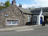
The tearoom & museum
We did a few miles of the old railway line before heading back to the cafe for a well deserved coffee and snack. Total ascent just over 630 metres so a good exercise.

Traps?
This walk including the railway section about 4 hours but that included lunch break, photo stops etc. One strange observation. On almost every watercourse a tree stump was set with a trap as per the picture. None of the traps were baited but they appeared to be set. We could only think that these were for stoats or weasels to protect the grouse but not sure. There were plenty of them around the area.
An enjoyable day out.

Tuesday, 28 May 2013

Cycling the local up's and downs

The weather forecast suggested a nice day ahead but this is the West of Scotland. The view from the house out towards the west was of a mainly blue sky but the view towards the east and inland, where I was heading, was rather dark grey. However, I wanted the road bike ride today so off I went. 
I headed along the Troon cycle path towards Prestwick airport then headed up to Monkton passing the search & rescue helicopter base of HMS Gannet but the machines were hidden away or out on a rescue. I was now on quieter country roads which included a bit of climbing and obviously fast descents eyes ahead for the potholes. I cycled up the Galston road. At the crossroads it was decision time, turn left for Galston and Tarbolton or right for Ayr. The wind was decidedly cooling and I was glad I had put on a windproof jacket. The clouds were now dark enough to suggest rain so cowards decision made, I headed back towards Ayr which brought me to the Sandyford roundabout. The countryside around here is typical lush green fields, the mainly dairy cattle were now out of their winter byres and almost every field was occupied. 
Normally I am very aware of traffic behind me but out of the blue a motorbike screamed past, it gave me plenty of room but what a fright. I was on a bone-jarring fast descent so I could not look back, then 3 more bikers came flying past, impressive, but not for my heart. 
It was too short a ride to head homewards so I turned back inland on the Mossblown road, passing through the village, up the hill to Enterkine house and headed towards Coylton. I had put in a bit of effort so decided my 1st drink stop would be at the River Ayr bridge where I could look out for trout rising if I was lucky. Arrived at the bridge, looked down and no water bottle in the rack. A few curses, I was sure it had not fallen out so I must have left in in the kitchen after filling, dumpling!!
River Ayr from the bridge

Trout ripple bottom left

Some trout rising today but not many, the water level was perfect but the coldness is keeping insect hatches back. I did watch a dipper flit from rock to rock, sticking its head underwater searching for food.
But no water so onward, still cursing as quite a few hills to go and no shops for some time.
A few ups and downs and I came to a back road signposted for Ayr. I had no map but decided to use it and glad I did. Nice and quiet country lane with the biggest climb of the day. One of those sods that you think you have seen the summit until you realise that was just a false top, turn a corner and still more climb, out of the saddle, blowing away but finally made it. It cut out most of the busy Coylton-Ayr road which is traffic heavy with no cycle lanes so worth the effort.
Back via Ayr to Prestwick beachfront and the cycle route home. At least Barassie beach is popular with the wind surfers if not the sun bathers this year.
Last years annual windsurfing show

Waiting for the starting horn

A good lung bursting session, just over 31 miles, not quite Tour de France mountains but good enough for me today.

Thursday, 23 May 2013

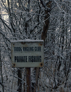
Collenan Reservoir - Troon Angling Club

Collenan reservoir is the home to Troon Angling Club. The club was established in 1936 and is a perfect place to spend a mid summers evening. The reservoir covers approximately 8 acres and it is a comfortable walk around its perimeter. This used to be a functioning water supply for the town of Troon but it's water comes from elsewhere now. The club was handed exclusive use of the water in return they are linked to some maintenance responsibilities.
Collenan is a private fishing club, it's members are mainly Troon residents and from other nearby towns, although day tickets can be purchased by non members. Better if you know a member as they will get guests at a reduced rate. The reservoir is stocked on a regular basis mainly with rainbow trout although some blue and brown trout are included from time to time.
The weather has not been kind for anglers over the last couple of years in our area, suffering particularly from the snowy winters which as you can see from the photos were definitely not fishing weather unless you were adopting the Arctic methods of cutting a hole in the ice. That, however, would be illegal on this water as the reservoir is strictly fly fishing only. This means that spinning rods and using bait are not allowed methods. 
Additionally the wind is a major factor when fishing here. Collenan stand above the town of Troon within the Dundonald hills. It is only about 200 metres above sea level but that is enough to to be a different climate from the town below. Basically the water is a triangle with a dam wall running its length to the west. you can see from this picture that it is tree lined on one side and on the other a field rises another 30 metres or so. The effect is you have a wind tunnel from west to east and vice versa and recently these winds have have been extreme and unrelenting.
Along the side of the woods is the 'smugglers trail' which is the route taken between Troon and Dundonald. The smugglers would go to the coast and lure ships in and their cargoes plundered. This has become a very popular low level walking route and mountain bike trail.
Collenan can be a hard water to fish, when the wind blows casting can be difficult and the fish seem to retreat to the middle of the water outwith casting range. No boats or float tubes are allowed so you have to wait for them to come in close. At times you would swear that there are no fish in here at all. On other occasions when the hatch is on, the water can be boiling as the take the emerging insects on or just below the surface. Then you have dry fly fishing of a very high standard with spectacular takes. This is exciting fishing when using dries or buzzers. It's true that big fish often take the smallest flies.
When the fishing goes quiet there is plently of wildlife around. The woods resident buzzards are mobbed every time they fly by the resident crows. Sparrowhawks try to take the smaller tits; blackbirds; etc. The great spotted woodpecker drums in the trees. In late summer the blue dragonflies are abundant. The trout will crash into the reeds trying to dislodge them or take the spent ones from the water surface.
All in all a good place to fish or walk, try it some time.


Wednesday, 22 May 2013

Loch Bradan & Cornish Hill

Well today we changed our walking plans due to the West Scotland weather forecast. Our original plan was to go up Ben Venue in the Trossachs but the wind forecast was for strong 20+ plus cold northerly winds gusting to 40+ most of the day. We reckoned we would have little shelter from this so no real fun, is it really almost end of May??
So off we went for a low level walk around Loch Bradan.


 In truth this was not the most exciting walk we have ever had but we were outdoors enjoying the wild bleak, sometimes beautiful Ayrshire landscape.  The landscape is fairly bleak, particularly on the eastern side of the walk. On this side there is a connecting walk/mountain bike route through these hills that takes you to Loch Doon via Loch Finlas but that is for another day for us. If you do this as a walk it might be better to leave a car at each end. However, the loch walk was a pleasant enough exercise for a day like this. The south end of the loch has the impressive main dam which supplies water to much of Ayrshire. When you walk behind the dam you see the impressive structure in full. 


On the open spaces the wind still had a hard cutting edge so despite some sunshine my light weight jacket was constantly on and off. 
Sadly there was minimal wildlife to enjoy today, a couple of male red-breasted merganser at either end of the loch (maybe the same bird) was all we saw on the water. However, the highlight was a beautiful wood warbler. It was absolutely fearless as it posed on its bush and small trees never going far away from us or its favoured spot. Indeed an enchanting sight and it made our day. Apart from that there were some regular sightings: chaffinch; blue tit; blackbird; thrush; but really not a lot around today.
The loch is a stocked with rainbow trout with wild brown trout in addition, but there was little evidence of either today. You can get a permit for £8 a day as well as the rights of the Ayr Angling Club. A brief swirling of rainbows feeding near the surface of the small north dam (below) was all we spotted. 

No anglers were around and it looks a dour place to fish particularly on a day like this.
The walk took us about 2.5 hours so an easy morning.
We had some lunch in the car park looking over the wild barren moorland hills when a military jet appeared low over the facing hill and flew right over us. Whatever your views they are an impressive sight.
We decided to drive back and take in the short walk to Cornish Hill. 
Park at the Stincher bridge parking area. You quickly go through enclosed woodland and it opens out to a good trail taking you up to the small cairn. Keep looking around as deer, sika and roe, as well as red squirrel can be seen, but not today.There are some interesting vistas on the way up for you to stop and look both north and to the west back over Loch Bradan. Cornish hill measures 467 meters in height but as you are starting up fairly high already this is not a difficult walk for most people. Once you get to the top you have some fabulous views looking down to Cornish Loch (below) and southwards over Shalloch on Minnoch and towards the Merrick. The wild scenery is an impressive indicator of the bleakness and remoteness of this area. You can imagine Robert the Bruce fighting the English nearby and the repression of the Covenantors, hard wild times meet a sympathetic landscape.

You have two options now, you can continue down the path to the loch and follow the marked trail back to the car park via the burn or you can just retrace your steps. The walk will vary between 1& 2.5 hours depending on your route.

Wednesday, 15 May 2013

Craiglee Loch Doon

My walking partner was back from his holidays so back into our regular Wednesday routine. The weather forecast was mixed but we decided for a high level walk from Loch Doon climbing to Craiglee via the brilliantly named Wee Hill of Craigmulloch. I don't think that there is a big hill of the same name!! 
There is a starting point from the castle ruins but we added a bit more to the walk and started at the forestry track road junction, good car parking. There is a sign saying 'Craiglee path' so you can't get lost. Craiglee from near the start of walk shown below.

The initial route is up a reasonable path which climbs nicely already giving good views. just before merging with the castle route we were skirting along the edge of the tree plantation when we heard a cuckoo calling. We were at the bottom of the 'Wee Hill' before we spotted it sitting on a tree at the edge of the plantation. A good view through the binos confirmed it as the cuckoo before it flew off. To be heard but not seen again. My first sighting of the year so well chuffed.
The path is now gone, or we lost it, and it is a good pull through tough grassy tussocks to get to the top of the Wee Hill. The views back on the climb to the south of Loch Doon are superb. Looking left over the water to the ridge containing Coran of Portmark, Meaul among others on the range. Looking directly south the Merrick range shows well and to your right the range of Shalloch of Minnoch as shown below.

Included in the panorama are numerous lochs and open country, just brilliant.
Puffing we reach the summit of the Wee Hill at 421m, a good walk. The views up and down Loch Doon well worth the effort.
If you want you could stop and retrace your steps and enjoyed the views. To get to Craiglee you descend across rough ground about 150 metres and then you have another short but hard walk up to Craiglee at 523m. Moi at summit.

Two grouse sprung out of the heather on the way up but that was all we saw of them this trip, I think they have suffered badly in the harsh winter. The wind was very strong at the summit so we did not linger too long, but still excellent views of Lochs Finlas, Derlach and Bradan. Also views of the Arran peaks and the top of Ailsa Craig all wonderful.
We went down 50 metres or so of the south ridge where we stopped had lunch behind a huge rock for shelter and took in the magnificent views. Luckily for us the rain was sweeping either side of us in short showers but we escaped any direct hits.
Our descent was via the south flank of Craiglee, our route strayed too far south so we had to make our way back along the tree edges to get back to our path. OS map not fully up to date with tree forestation works.No big deal and about 20 minutes extra. However we did see an Orange tip butterfly and a few Wheatears on the way down. 
Back to the car, all in all 3 hours 15 minutes walking, 611 total metres climbed. 
As always in Scotland you do not have to go too high to get fabulous views. Well worth the effort. The legs will feel it later.

Tuesday, 14 May 2013

River Irvine...a successful days fishing

I had to get a bit of fishing in today, Penwhapple was still on my mind. It was still windy, wet and cold but I had to get outdoors. Walking along the river bank my hands were feeling the cold and I do confess I was pondering my decision but as I was outside anyway, let's continue was the attitude. Glad I did as it turned out to be a cracker. The river was choppy but it looked as if some fish were rising to feed from the surface, the sand-martins were in the air so on with the dry flies. The right decision as within 20 minutes I had 2 brownie parr and one salmon parr on a small olive. I changed to an olive CDC and immediately took a better fish around 3/4lb - 1lb from mid river. Ignore the bit of paper at it's head. It went back to fight another day.

I could see bigger surface rings so hopefully bigger trout, but as always they were over the far bank and it was a long cast in this wind. However, I made it and on the 3rd down river drift, bang, I managed to get my best trout from the river this year, circa 1.5lb. Regrettably I could not take a photo as just as it was posing on the bank-side beside my rod, it did a major flip and slid back down to into the waters of the Irvine. It was going back anyway but the photo would have been evidence, a few curses were uttered.
Wildlife today, not much apart from the Sand Martins.I did see my 1st Swifts of the year, half a dozen flying high over the river for a few minutes taking the insects high up. Also, a beautiful mute swan came downriver at a cracking pace. Its wings were curved back and picture perfect. Not sure what the raised back wings signify but it was in a hurry. Huge forward propulsion from its webbed feet under water. A lovely sight. Another couple of brownie parr then the feeding was over. A very enjoyable couple of hours, surprising with the weather.

Monday, 13 May 2013

Penwhapple 'It was hard'

Well Saturday the 11th was our 2nd trip of the year. Forecast was not great and when we arrived it was chucking rain down, blowing a hooley and cold. It tells you everything when the guy selling the permits, Jim I think was his name, looked at Colin and I and said "your surely not fishing today, are you"? Well the answer was yes we would give it a go having driven 30 odd miles. Shaun was already waiting at the car park, the Lunardi's late again and sadly Ally had to pass.
Despite the wind belting down the water and a distinct chop that looked more like sea waves to me, Colin & Shaun took a boat as they had the electric motor. The rest of us decided that we were not rowing in that weather so bank fishing for us. Despite the terrible weather the martins were flying in the middle just across from the boathouse and some fish seen rising. The martins remained in small numbers all day but rarely saw another fish rise.
Before the rest of us had even wet a line Paul was into his 1st fish. Great day for him as he got 7 in total inc 1 brownie, his best for yonks. All caught on an orange dancer type lure using a sinking line. For my part I hooked into 2 fish which were well on but both came off for some reason. Both of mine took a black Zulu red tail and I used a floating line. The other guys all caught including another brownie to Colin. The fish were top fighters and excellent sport.
The constant rain went off around 11'ish but the wind was relentlessly strong all day and in turn made it a long cold day. So wet I never even took a photo today. The wind-farm turbines hummed constantly and spoiled the view big time.
Will be back on a nicer day to give it another go. This was one cold long and frustrating day.