Wednesday, 29 May 2013

Lowther Hills

Today was full of promise and optimism. Last nights weather forecast indicated a pleasant day ahead so the decision was made for a high level walk today.
An hours drive took us to our starting point the village of Wanlockhead which is the highest inhabited village in the UK.
Wanlockhead from the start of Lowther Hill
The 6 mile drive in from the Dumfries road to Wanlockhead, (Mennock Pass), has to be one of the prettiest drives you can take, on a clear day with a view of the rolling surrounding hills which enclose the pass. The winding road initially follows the burn through woodland opening out to the surrounding grandeur of the rolling hills dominating the vista. The meandering burn is still panned for gold which in the past has been used for making Royal jewellery. We saw several prospectors at work/play today. This area was also an area of battle for the Covenantors and the dragoons with a massacre of dragoons recorded close-by. The village was historically a mining village which now has a museum and some relics in the working areas. The Southern Upland Way also passes through the village.

Parking is free and the free toilets, linked to the cafe, spotless.
Our plan was to climb to Lowther Hill as a starting point then to move up the ridge eastwards via Green Hill. As always the 1st rule of planning be prepared to change.
Lowther Hill towards summit
The climb is a fairly straightforward pull up the hill following the Southern Upland Way path.  The summit is the great ball courtesy of air traffic monitoring which is a landmark but not the most scenic. As we progressed the wind was picking up considerably and it was not warm air. About 2/3rds of the way up we both had to add an extra layer, not what we expected. By the time we reached the summit the wind was howling in from the east to the extent walking was becoming quite difficult. This is almost June!!

The radar ball
Path to East Mount Lowther
The summit ( the radar ball ) tops out at 725 metres but the advantage of this walk is that you start at 432 metres so the overall climb so far just under 300 metres. I am surprised that you are allowed access to this centre, although there are warnings that it is monitored and expect to be shot etc if you try to break in. The wind was still a real issue so having had a good look around at the surrounding vistas we decided that heading into the east wind along the planned ridge was not the best plan for the moment.  We jumped a fence and followed a sheep trail back down the lee side pf Lowther hill until we reached another path which we could take to East Mount Lowther which was fine as neither of us had been up this one before. This top is radar free, brill, it is a Donald with an altitude of 631 metres. It was a straightforward climb to its summit.
Moi at summit
At the top there is a very strange trig point, seems like a bit of pipe!! but with a good pointer indicating what can be seen in each direction. Our views were fine today but on a clearer air day the full panorama would be spectacularly impressive. Still, we could easily pick out Tinto to the east; the Merrick and Carsphain to the west. The surrounding rolling hills and glens are really special, the hills are patchwork quilts of heather as these hills grouse shooting areas, the number of gun butts indicate to what extent. Surprisingly we did not spring one grouse, red or black, maybe another indicator of how hard the winter has been up here. Indeed, we saw very little bird-life today apart from meadow pipits and skylarks plus a pair of ravens displaying for a short time. Very disappointing.

The weather was closing in, impending rain, so time to head back. The walk along the north side of East Mount Lowther gave us a different perspective of the Mennock Pass and despite the wind was enjoyable. But time to head back to Wanlockhead.
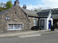
The tearoom & museum
We did a few miles of the old railway line before heading back to the cafe for a well deserved coffee and snack. Total ascent just over 630 metres so a good exercise.

Traps?
This walk including the railway section about 4 hours but that included lunch break, photo stops etc. One strange observation. On almost every watercourse a tree stump was set with a trap as per the picture. None of the traps were baited but they appeared to be set. We could only think that these were for stoats or weasels to protect the grouse but not sure. There were plenty of them around the area.
An enjoyable day out.

No comments:

Post a Comment