Saturday, 20 July 2024

The Outer Hebrides high point.....An Clisham

 Hill: An Clisham (Rocky hill)

Type: Corbett

Height: 799m


On a short break to the stunning Outer Hebrides the good lady had graciously allowed me a free morning away from the tourist hotspots to get some solo walking done. I had a choice of a few Fionas/Grahams but the obvious decision, despite the drive back and forth from our digs, had to be the highest peak on the islands, the Corbett of An Clisham. I had watched Paul Murton ascend it recently on one of his repeat programmes, good enough for Paul good enough for me.

View from parking

I was away sharp and arrived at the empty parking area for 8.30 walking. It was a very cold morning, despite it being well into official Spring nobody had told the temperature gods, the NW wind very unseasonably. Indeed the next day snow was covering the tops of Northern Scotland and we had a hailstorm, not good but the oldies will say we have been here before.

As I changed I heard a Cuckoo calling, my first of the year. It sounded far away and did not repeat its call, was I mistaken? A check on the islands bird forum later and the first arrival had been recorded two days before. Good news but still to actually see one.

There is an option of a full day ridge walk which from the top looked quite spectacular. But today time and logistics meant it was a straight up and down, maybe another day.

Kitted up and looked at my GPS to find I had not loaded the walk before we left for the trip. Luckily visibility was fine so I was not backing off.

As per descriptions I followed the south bank of the burn although from the parking area the right looks the more trodden but it really makes no difference.

The initial section is described as boggy which is a kind description, possibly the recent heavy rains have made it worse but gloop fest it was.

A disappearing golden eagle

Towards the top of the burn I got some movement in my peripheral vision and was delighted to see a pair of golden eagles. Not for long as a pair of ravens dived down from Clisham, harassed them a bit before the eagles slowed spiralled upwards to disappear high above me.

Looking back spotting cars


The path had disappeared only to be found again near the top but in reality it did not matter as the going was not difficult. There are plenty of crags but they are small and easily avoided. Line of sight let me follow grassy rakes between the boulders with only some minor scrambling. About half way up I looked back and saw another car arriving at the parking area, so not a solo hill after all.

Rough but straightforward

Great views to South Harris and the Uists

Wide view


The final section was much more rocky and did involve more scrambling. I could hear a very loud call of an eagle. I reckon it was on the other side of the boulders but I could not safely get over to look, I have never heard a raptor so loud and so nearby.

Summit cairn ahead


Finally the summit, a trig point surrounded by a circular cairn. But, just along the ridge is a more normal cairn. Just to be sure I wandered along and it is a good view point but I reckon it is more of a marker for those doing the full ridge walk.

The ridge in the sun


Slightly hazy but overall excellent views and well worth the reasonably short effort. Looking west the odd stretches of golden sandy beaches and blue water highlighted the beauty of this area.

Way down

Boggy section before the road


Took more or less the same route down. But the descent was much more focused as lots of muddy sections alongside scree sections gave good odds of a mishap if care note taken.

I met two groups of walkers, stopped and had a brief chat with them, all English voices.

Flat boggy section seemed even more boggy this time around and before long I was back at the car. Not warm but not as cold as the start.

Delighted to get another Corbett done a bonus that it was the high point of Lewis & Harris. Time to get the good lady and more tourist stuff.

Ascent: 662m

Distance: 6.01km

Time: 3.21

Wildlife: Golden Eagle (pair); Meadow Pipit; Raven (pair); Cuckoo (heard)


A new one for me.....Ben Newe

Hill: Ben Newe (pronounced now)

Type: Sub2k

Height: 565m


I had this hill pre-planned as a gentle leg stretcher after yesterdays epic. What I hadn't pre-planned was the effect of a very sore blister and how it would cope with this hill. I had actually planned two short hills but I suspected one would be enough.

It is described as a woodland walk with a clear view at the top but there has been so much deforestation that most of it is now an open walk with trees on one side at most.

Not very attractive start


Nicest stretch

Summit up in those trees

Hardest bit was not to miss this track or an unpleasant clamber over that terrain

Ben Newe has its own route description on Walkhighlands which is rare for a Sub2k. But in reality you cannot go wrong as it had been picked because there is a trail all the way to the summit, plenty of marker boards around, probably to keep you away from the timber workings.

The positive about the remaining wooded sections was the birdsong, it was non stop singing and calling and particularly on the descent I took the time to stop and enjoy it.

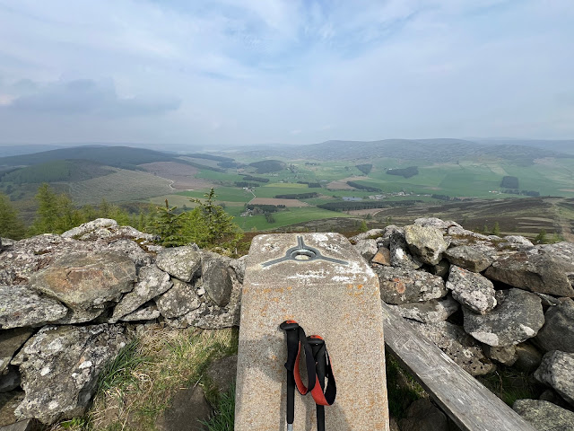
Trig in sight

Hazy view north

Hazy view south, Lochnagar on a good day but not this one

The trig has a small stone enclosure with a couple of wooden benches, you don't see much if you sit on them.

Storm Arwen's destruction evident all around

There are very pleasant views looking down on the green Strathdon farms and landscape but the haze meant no long distance views. On my descent I met a local walking his dogs who told me that on a clear air viewing day he had made out Ben Rinnes, a long way away indeed so I need to take his word for that.

Although I had gone for a short walk it turned out to be even shorter than expected but my blistered foot was not disappointed. I had a second Sub2k planned but I will leave that for another day.

Ascent: 220m

Distance: 4.52km

Time: 1.41

Wildlife: Tree Pipit (1st this year); Wren; Robin; Pheasant; Coal Tit; Jay; Siskin; Crossbill; Willow Warbler; Great Tit; Buzzard; Chaffinch; Blackbird; Goldcrest;


Friday, 19 July 2024

Another volcanic plug.....A'Chruach

Hill: A’Chruach

Type: Sub2k

Height: 514m


When I woke up this morning I had no plan for the day. Opened the curtains and a nice morning. Checked the weather forecast, winds building but clear. Checked CalMac status, no issues showing. Decision made, a quick preparation and out the door heading for Arran. Luckily my rucksack is almost permanently ready to go.

A’Cruach was my second last Sub2k to do on Arran but I knew that it had a not so positive reputation. Only 64 people have ticked it off on Walkhighlands, that tells its own story. From whichever direction you approach it is said to be a totally pathless boggy moorland walk. Walkhighlands describes it as ‘ quite dreary by the standards of Arran’. But in its favour it is the highest point on the south of the island, as split by the String road, so it deserves to be bagged.

The terrain is not quite the best as I can testify to but possibly because of the time of year it was not as bad as I feared. In saying that it is not a hill to do with snow lying as the bogs and hags are many and deep and could be very dangerous terrain. It is also not a walk to do in high season as the bracken and deep heather, tussocks would make it very difficult.

Lastly, unless you are very sure of navigation it is not one to be done in poor visibility. It is a large featureless moor and although the top is a volcanic plug you would be hard pushed to imagine you are on one. Cruach means an upthrust of rock/stack, appropriate for a volcanic plug.

Now that all the warnings are out of the way here is the trip report as told mainly through the narration of the pictures.

To get to the walk start I got the bus to the top of the String Road, the driver was happy to let me tell him where I wanted dropped off, no formal bus stops up here.

It is behind the high lump centre right

Starting point

Headed for the low point but came back descending the heather

Rough moorland to get to the high point

Wooden narrow walkways required

Summit looking over Glen Rosa

Descent initially heading towards Holy Isle

Hidden building

Thats the descent

Aiming for the white post, safe route for ATV's

Zoomed into Glen Rosa

Cairn appears much larger than summit one

String Road below

Lovely view from Brodick

The downside of the walk at this time of the year was CalMac's fault. There is only one ferry operational which meant a long delay between finishing the hill and getting on a ferry, no buses this time. This meant a walk back down the road. Not a hardship as it was a nice day and on this section I saw my red deer munching away on the slopes and a solitary golden eagle coming from Glen Rosa direction, flying over me towards A’Chruach before gliding down the ridge and heading back to Glen Rosa.

Also the hanging about meant time for a visit to the Douglas Hotel whilst waiting for the ferry, such hardship.

Ascent: 319m

Distance: 6.3km

Time: 2.29

Wildlife: Red Deer; Golden Eagle; Buzzard; Kestrel; Grey Heron; Carrion Crow; Coal Tit; Goldfinch; Wren; Robin; Mallard; Chaffinch; Black Backed Gull;

99 up but no ice cream yet.....Creag Dhubh (Glen Spean)

Hill: Creag Dhubh (Glen Spean) (Black cliff)

Type: Fiona

Height: 658m


My ascent today was almost a case of deja-vu. I had planned this hill one day last month but after a long drive, just as I arrived, the heavens opened and the wind was blowing a hoolie. I stepped out of the car and immediately stepped back in, no motivation, not happening.

This week it was the meteorological summer weather but it was totally unseasonable, very high cold northerly winds from the Arctic resulting in snow lying on the high tops, a distinct lack of sun and warmth. Another why do I live in this country debate as the year to date has been abysmal?

I was heading north for something else and I was literally in my bed this morning looking at forecasts before deciding to take a chance, a low level walk would be done if required.


A no rush drive, brekkie at the Green Welly meant it was about 12.30 before I reached the start at the paring area near the church and cemetery. Surprised to see that there was another fool parked up. Hillwalker or grave visitor? A well kept graveyard with a good view. The old church Cille Choirill thought to be here since the 15th century.

Now I can see the hill

But heading away from it to start at the grassy area in the distance


I headed up the grassy slopes at the carpark to get a view re where I was going before heading for the junction of fences that I had read about. This point is also a section of the parallel roads, seen on map, but it was not obvious.

Creag Dhubh is a typical Fiona. It is pathless. The going is rough boggy moorland. At lower levels all around the hill the bracken was fully in growth and in a month would restrict route options.

It is a hill where you can always see just so far but never far enough.

Aiming for the point in the middle


I was following the easiest routes that I could find, on-off animal tracks, grassy lines through the tough heather sprigs and avoiding as many boggy patches as possible.

About half way up a figure appeared over the ridge on the descent, the person from the other car? It turned out it was and also it was someone I knew, so we had a few minutes chatting, which was good for me to get a breather.

Now towards the lump on the right


It is a short walk and after about 30 minutes of ascent it started to level off and I stumbled across an ATV track which initially brought some easier walking before disappearing.

Then it shows itself


Now it was just a case of plodding on. As mentioned earlier I could see a rise which as soon as I climbed it brought another rise and so on. Not overly hard work but it gets a bit annoying, where is the top? As it turned out I didn't see it until almost on it.

Cairn & trig looking north

View west


The wind had been coming off the west and behind me so I was not as aware of it until I reached the open top section. Wow, I was now in the ring with Mike Tyson, being fully buffeted and battered, the wind trying hard to turn me around. The trig was a welcome sight and on a good day it would be a fine spot to hang around with good views. But struggling to stand I wanted away from these winds so no hanging about.

The terrain on the upper sections of the descent seemed rougher and from this perspective much wider and open. In bad weather there is no real difficulty re crags but the way the terrain lies it would be very easy to start heading north into very remote countryside.


I was glad to drop below the wild winds and enjoy the descent and the views. The very snow clad northern flanks of Aonach Mor dominate but plenty more to see in the grey skies.

Graveyard mid left & Cnap Cruinn behind

The church
There were plenty more Skylarks and Pipits rising but absolutely nothing else, a disappointing wildlife day.

Overall it was exactly what I expected so I was not disappointed, despite the negative of the wind but the positive of no rain. A good ramble that sets the legs up for tomorrow if the forecasted winds allow that to go ahead.

Ascent: 549m

Distance: 5.6km

Time: 2.18

Wildlife: Meadow Pipit; Skylark