Thursday, 24 June 2021

Third time lucky....Meall Buidhe.....Glen Ogle

Hill: Meall Buidhe, Glen Ogle ( Yellow Hill)

Type: Graham

Height: 719m

On my way to a planned trip I was looking for a quick up and down hill and decided to travel via Glen Ogle to tackle this hill at the 3rd attempt. On the previous two occasions I was intending to stop off on my way home but the weather was awful both times. Not a walk to bother about without the views unless you are a don't care less bagger and to be fair there are a few of them around. This time the forecast looked good for everywhere in Scotland apart from this section which was forecast for showers and yes they arrived. The annoying thing was that 10 miles down the road Tyndrum had no rain at all, that's showers for you.

Although this is categorised as a Graham the starting point is at the top of Glen Ogle thus giving a head start so an easy walk. 

Ferns here had grown to head height
At the start the track starts beside the car park and the ferns had grown much taller here than recent hills but luckily I was not wading through them. Food for thought for planning future walks.

There is an aerial mast about two thirds of the way up the hill so unless you are a masochist and want to go cross country the service road is the one to take. This zig zags its way up the hillside making progress even easier. 

1st view of the crags at the mast
Initially the track meanders through trees but then opens up to give you a view of the mast. 

Almost out of the plantation
Further on the track escapes the trees giving good views which become better as you ascend. The clouds were rolling over but no rain yet.

High point Meall Buidhe from the mast just pick a route
From the mast the cairn can be seen but the terrain in between is full on moorland, not D&G tussocks but not far off. The walking was awkward but not difficult. There was the occasional very deep hole to keep me wary but mainly it was heather and sphagnum bogs. 

Typical peat hag moor
After about a kilometre the ridge was reached and surprise, surprise on came the rain. I had swapped to my light rucksack and had put in a waterproof jacket but not the trousers, so wet shorts!!

The big cairn as a shower passes
Once on top there are two of cairns, oddly the smallest being the high point. 

Looking down Glen Ogle towards Lochearnhead
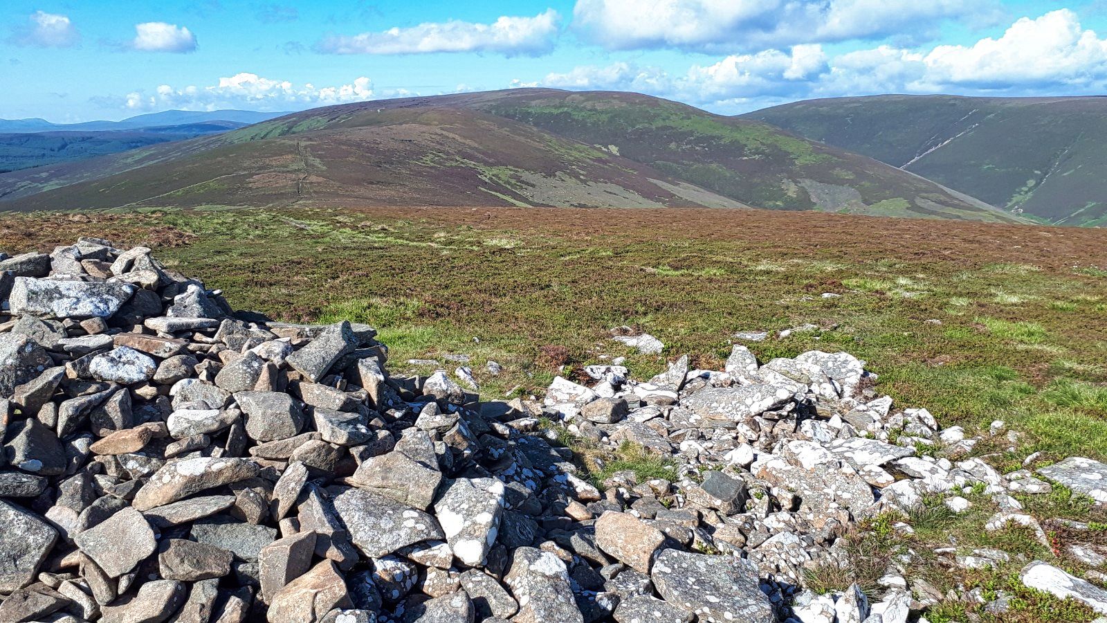
Slightly further west there is a more substantial cairn which would normally give good views down into Glen Ogle but for me atmospheric would be a better description as the clouds prevented downwards looking, still not bad.

It had been a short walk and I was feeling good so rather than return the same way I decided to head along the ridge to the north top of Beinn Leabhainn. Strongly recommended as even in these conditions the views are so much better and on a good day would be quite stunning.

The traverse is not all ridge, there is a descent into more very wet bog but thankfully short lived before heading up the ridge again, once on top the cairn is in sight. Fresh deer and grouse droppings around but no live ones spotted.

Killin with Lawers range behind

Loch Tay
As you head towards the cairn good views of the Lawers hills directly ahead and to the east Loch Tay opening out more and more. 

Looking West up Glen Dochart to Tyndrum
From the cairn the full vista also covers the Tyndrum hills and closer the Munros along Glen Dochart. Pretty dammed good but would be fabulous with the air clarity I had on Dun Rig.

Mast ahead
From here the top of the aerial can just be seen peaking over the horizon. Easy navigation and an easy descent albeit along more poor walking terrain but the aerial mast is soon reached.

Winding track back to the start
To finish just follow the track back to the car. A young couple passed me heading up, the only people seen on the hill all day. 

Back at the car the humidity had brought out the midgies and they were having a feast with me on the menu. I had midge spray in the main rucksack but I was getting so many bites that I abandoned trying to find it. Simply jumped into the car and drove away with the windows open hoping they would be blown out. Maybe some did but others lived to continue the feast.

An enjoyable walk and definitely a small hill to return to when the weather allows the views to be enjoyed in full.

Annoyingly when I got to my digs and checked the weather forecast for tomorrow it had changed and was very poor indeed. I had planned to kickstart my Munro count with a Dalmally double but the forecast was predicting heavy rain and very poor visibility by lunchtime, so a rethink required. Next blog will tell what happened.

Ascent: 474m

Distance: 9.1km

Time: 2.28

Wildlife: Chaffinch; Blue Tit; Meadow Pipit; Small Heath


Wednesday, 23 June 2021

Rollercoaster circuit of Dun Rig

Hill: Dun Rig (Dull brown Ridge) (744m); Birkscairn Hill (Cairn above Birks(farm)) (661m): Glenrath Heights (heights above Glenrath farm) (732m): Stob Law (no known name) (676m)

Type: Graham x1, Donald x4

Another opportunity from my Edinburger trip to detour on the way home this time and save adding mileage to busy milometer on the car. Time to complete the long Dun Rig horseshoe. 

The star of the bunch is Dun Rig which is a Graham and the highest point of the Manor hills. Alongside the walk is a horseshoe collecting another 3 Donalds. Planning stage and this is a long walk as unfortunately all the bagging hills are at the far end of the horseshoe. The plus side is that it is a long walk in beautiful rolling border hills so embrace and enjoy. I was tempted to do this last week with some friends but the forecast was rubbish, glad I waited.

Looking back to Peebles shortly after the start
Today the forecast was good with blue skies overhead when I started the walk from the traditional spot at the end of Glen road. In my planning I debated the less reported anti clockwise route but ultimately stuck with convention. There were no wind issues to factor in so off I went, another test for the recovering legs.

It is a long walk in with quite a few ups and downs before the first Donald of Birkscairn Hill is reached. I followed the old drove road which is a cracking start but the climbing starts almost immediately. It was early morning but before long the I was dripping, boy was it warm. In the early morning light a stunning russet coloured field hare briefly appeared and disappeared. 

The high level walk ahead with Dun Rig centre
It did not take long before the views opened out and I had an option to go over or round Craig Head. On a better fitness day I would have gone over but still tired legs I followed the drove road round around the hill There will be enough climbing ahead. The signpost warned of coos which were spotted but not interested in me.

Cardrona forest on the left, track up to Kirkhope and Birkscairn behind centre
The drove road continued beside the forest with excellent views of the horseshoe ahead. A few more ups and downs before the long pull up Birkscairn Hill and its big cairn. I was having a break and eating my banana when I heard a snort and a springer spaniel appeared beside me. Its owner said a brief hello before jumping the fence and headed off downwards towards Birks Hill, He was the only person I saw all day.

Dun Rig ahead from Birkscairn, Glenrath behind on right
Off now with a clear view of the fence ahead that would lead me to the peat hags and then Dun Rig. The ground was as dry as it probably could be but no doubt that this section from here to Huddlestone Heights could be a significantly different/harder walk with the hags and sphagnum bog terrain.

Dun Rig trig
Dun Rig trig reached without incident, just under 3 hours, pleased with that. Another food break, a good scotch egg and take in the views. 


Half way view back from Pt713m

The horseshoe heads further south, following the high ground, before turning round to head for home and the next Donald of Glengarth Heights. This section had some serious hags here. Even in the very dry conditions my feet were breaking the crust and sinking in quite deep, the joys it could be after a prolonged wet spell!

A raven flies over, the first and only corvid spotted today and on Windlestraw circuit the other day.

Heading back now Glenrath Heights ahead with Stob Law back left

After the turn another fence to follow, plodding slowly up the slopes of Glengarth Heights with one eye looking at a top over to the far left which my mind was in no doubt, that was the spur of Stob Law. 

Glenrath summit looking to Drumelzier hills
Excellent views particularly to the western hills of Coulter, Tinto and the Drumelzier hills. No jagged peaks but still a special view.

Looking to Stob Law
When I reached Broom/Middle Hill the motivation to do an out and back to the final Donald of Stob Law was low but it had to be done. The descent was steep and when I reached the col it was rucksack off and followed the track to Stob Law, a strange feeling climbing a hill without the weight of a rucksack. 

The flatlands of Stob Law
Stob Law is a flat top with not a lot going for it, a few stones make up the cairn, it feels appropriate for the runt of the round. The descent however does give good views down into a deep valley on my left with some featuring crags interesting named 'Bleak Hope'.

The return to Broom Hill a lot steeper than the snap makes it look
I was feeling a bit bleak myself as I collected my rucksack for the return ascent to Broom Hill. A single wild raspberry was growing beside it. To eat it or not. I decided I would let it seed and maybe some future nutrition for Donald dafties. This was easily the steepest gradient of the walk so just kept muttering 'its the last climb' over and over.

Now really heading for home via Huddlestone Heights. Another moorland section strewn with hags and bogs, the softest terrain of the walk. A clutch of red grouse fledging's burst from cover, fun to see. 

Huddlestone Heights, Pentland Hills in background
Finally the last high point, Huddlestone Heights, a non status hill but it has a trig and more superb views of the horseshoe I have just walked in its entirety. There was a cooling breeze and the air quality was so clear I could see the Bass Rock and even further afield across the Forth the multi stories at Kirkcaldy and behind them the Lomond Hills. Makes all the effort worth while.

All that was left was the very long walk back out. From the trig there is an ATV track which follows the broad ridge of Dead Side passing more gun butts. Nothing left other than to enjoy the walk and take in the views. 

Raven trap
Near the old settlements I came across a raven trap. Clearly not in use at present but might explain the lack of birds seen. 

An excellent walk particularly with the weather but it was certainly a roller coaster of a walk, confirmed when I looked at the GPS profile. It would be a shame to do this on a cloudy day and miss out on the views. I would certainly do it again but miss out the spur, don't need to bag it twice lol.

Just two to go for a Donald completion, that will be July's task.

Ascent: 1068m

Distance: 24.7km

Time: 6.27

Wildlife: Field Hare; Woodpecker (pair), Pheasant, Buzzard. Raven. Blackbird, Jay (heard), Cuckoo (heard), Skylark, Meadow Pipit, Red Grouse chicks, Small heath butterfly,

Tuesday, 22 June 2021

Up & Down, Up & Down the result two more Donalds bagged......Windlestraw Law circuit

Hill: Windlestraw Law ( Hill covered in windlestraw grass ) (659m): Whitehope Law ( Hill above Whitehope farm) (623m)

Type: Graham/Donald

Heading for Edingburger I decided to detour to cover off these two hills and save myself some future mileage. A weather front was passing over when I left home, rain and breezy, but the forecast was for the walk area to be better by the time I would get there, we would see.

A lovely drive and for a change the sat nav GPS took me to where I wanted to be. It is a frustrating system. When I first keyed the coordinates last night it was directing me to Russia!! You have to be so precise the sequencing, spacing, commas etc this is meant to be an upgrade from my last car, no chance.

A strange road from Innerleithen as you go threw the middle of the golf course, literally play on both sides, hoping no bad shots hit the car, they didn't.

Start at Blackhopebyre
A lovely Borders glen with the road running beside Glentress Water which I have to cross later. The hills are on either side of the road so you effectively climb one, back down to the road then up and down the other. Not the best but it gets two hills bagged. 

I parked just after Glentress farm and walked up the road to Blackhopebyre farm and cut in to the constructed track. Low cloud meant no hill tops showing. The shooting track is in good nick at the beginning before becoming a newly scraped track which I bet they did not get planning permission for. 

Trench or track?
Not a lot to say just keep following the track onwards and upwards. Pleasant moorland views and no human noise, just the sound of the birds and there were plenty of them.

The track passes some well hidden grouse butts before a fence is reached and the ground is much rougher although the ATV track continues on and off so it is not a tough ascent.

Windlestraw trig looking towards Bareback Knowe
Finally out of the gloom a very white trig is spotted at the fence junction. The highest point in the Moorfoot Hills didn't seem like such from here in the gloom.

A choice to return same way but I decided to head for the Donald top of Bareback Knowe. 

Bareback Knowe looking back to Windlestraw the cloud has lifted
A simple case of following the fence, boggy at times but good time made. En route I found the hare and had a look to see if any raptors were lying about as recent cases of poisoned hares left to kill the others, but none spotted. 

Golden Plover
I could hear some frantic calling, must be near a nest, then spotted the well camouflaged golden plover, its partner started flying and calling, what a racket.

Descent from Bareback. Heading for biggest tree planting with Whitehope directly ahead
Now just followed the fence most of the way to the road. A rough section towards the end. Descending I could see the land layout over to Whitehope confirming my planning that I wanted to head to the top of the trees and head up the broad ridge from there.

Walk along the road to climb to right of trees
The legs had been ok considering it was a while since my last walk but I knew the next ascent would do them in and so it proved.

Whitehope Hill is slighter shorter but a much steeper gradient particularly the section from the road. A new bridge is in place then immediately up. 

Ferns about to hide the track
The ferns are sprouting already knee high and hiding some of the sheep tracks so at times I just crashed through them. In a months time it will be much tougher.

Steep bit over now a plod up the flanks
Glad to reach the treeline although the calves were burning. Lactic was building up. Again not much to say except slowly plod up the hill bypassing the heather patches. Some very boggy areas but mostly pathless and it was taking its toll, my legs were tiring more than I thought.

Fresh coo droppings made me more alert but I never came across them. 

Summit looking back to Windlestraw & Bareback
An hours walking got me to the small cairn summit, an hour from the road, felt like a lot more. 

Time to relax and have some food and take in the views particularly back to Windlestraw ridge.

Mistle Thrush
Then straight back down the same tussocky, heather way.  A bird flew out of the trees chasing a pipit of a rock, turned out to be a scrawny looking Mistle thrush, another flew past, youngsters or adults? The humidity built up with midges to greet me back at the car!!

I needed to get that walk into my legs and just 6 Donalds to go to completion. Straightforward but a lot of ascent for two small hills.

Ascent: 825m

Distance: 13.9km    

Time: 4.13

Wildlife: Peewit: Curlew; Oystercatcher; Rabbit; Hare(Dead); Golden Plover: Skylark: Meadow Pipit; Chaffinch; Mistle Thrush: Red Grouse.

Tuesday, 15 June 2021

The mighty An Teallach.....Awesome now that's a proper mountain range

Hill: Bidein Glas Thuill (1062m) (Pinnacle of the grey-green hollow) & Sgurr Fiona (1060m) (White peak) aka An Teallach (The Forge)

Type: Munro x2

I have had a longing to complete this traverse but I could not see myself doing the scrambling on the pinnacles. However, having read up on it the route from Dundonnell which avoids most of the scrambling, but not all, as one of our party took a panic attack on it, so a warning not all of it was straightforward for everyone.

The parking area was full, mainly due to the mountain rescue team preparing at their base, hopefully just a training session but they are around in case they are needed.

Look hard this is the good path

It is a long walk in but there is a restored path which helps greatly as it meanders upwards. Plenty of short stops to take in the views.

Little Loch Broom

It was not always easy walking but initially a zig zag at a good gradient made for a slow plod but height gained all the time.

Wow thankfully we bypass this one

After about an hour the impressive mass of Meall Garbh suddenly appears looking very challenging but today it is not for us we are bypassing it.

We are ascending to the right but valley will be our descent route

The ground becomes more sandy and rocky as we head for Sron a Choire, typical of the geology of this area. We could see walkers down in the glen, which will be our descent route and also spotted someone on top of Meall Garbh.

Sgurr Fiona looks mightily impressive

From here the objectives can be seen, First is Bidein which looks bulky and steep but a track can be seen meandering its way up. Then further on it is the much more impressive pointed Sgurr Fiona and the pinnacles which gets the awes, these are special. This is a proper mountain.

Bulky Bidein and pointed Fiona

First the stony, rocky, scree path has to be tackled. Actually the gradient is once again fairly kind for about half the ascent, a bit steeper then we reached a flat top with awesome views of the pinnacles.

Colourful lichen

Before that ascent photo time then we climbed the short final section to bag the first Munro of the day, Bidein a' Ghlas Thuill. 

Rare snap from near top of Bidein a' Ghlas Thuill

The views were every bit as spectacular and jaw dropping as I had hoped for, without doubt a WOW factor view. 

Fiona without me and the Pinnacles behind including Lord Berkely's Seat

Now a look at the ascent of Fiona. There is a ridge to cross first abd from here three tracks can be seen. The steepest and shortest goes up the edge of the corrie very steep drops. A fainter middle route but still more direct. But we opted for the more used track which goes about half way up, then what?

This is the view from Fiona to the Pinnacles

Once on the ridge the wind picks up and one gust is strong enough to take hats off thankfully not into the corrie but all headgear stowed away. The track is good until we reach that mid point. After that it is a case of walking, sometimes scrambling up the steep rocks, it still looks a long way up. 

Looking back to Bidein from Fiona

Without too much bother for most the summit is reached, a very small area with some large drops so no stepping back too far to get that better photo. 

Panorama from Sgurr Fiona

The views are breathtaking, deep down into the corrie and the full range of An Teallach's pinnacles where we spotted some walkers climbing the Lord, dangerous place and at least 4 people have died climbing these hills in recent years.

View down to Toll an Lochain and wild land beyond

Sail Liath

An easy short downwards scramble for a nourishment stop and more viewing before heading homewards. 

The reverse ascent of Bidein 

Some traversed Bidean but a couple of us went back up to Bidein (now 3 Munros lol) before going back down the ascent path. Straightforward I thought until a minor slip on the steep track, thanks to the stone marbles, hand hit the ground, sharp pain and the top of a finger was hanging loose at a very odd angle. Unbelievable, a small slip and now a torn tendon, mallet finger, with an potential long recovery, there goes tomorrows golf no gripping a club for some time with this injury.

Rough moor for the initial descent a contrast with the rocky ascent across the burn

We headed down the corrie, initially on a path which soon disappeared when we crossed the burn. Then rough moorland walking until we met up with the ascent track about half an hour later. At one point we thought we heard someone calling from the direction of Meall Garbh, was there a casualty? Then we saw some mountain goats with kids so presumably it was them.

Mum & kids

The last hour was a bit of a slog as the heat was ramped up and my water was very low so very pleased to reach the cars.

An epic round only marred by the injury but really pleased that I did it.

Ascent: 1368m

Distance: 15.1km

Time: 7.25

Wildlife: Mountain Goat; Raven