Showing posts with label Ayr & district rambling club. Show all posts

Wednesday, 31 December 2025

The low clouds and high winds didn't spoil our ramble.....Creach Bheinn Appin

Hill: Creach Bheinn Loch Creran (Hill of Spoil/Plunder)

Type: Corbett

Height: 810m


I visited Oban on a trip with Ayr & District which led to this ramble taking place as a Plan B. The original plan had been to ascend the nearby Munro of Beinn Sgulaird but weather forecasts implied much wilder conditions later in the day so this slightly shorter/easier walk was chosen instead. Easier, maybe yes but also maybe no, read on.

Both walks start from the same location. There is only a small parking area which was full so most of our cars had to park about 10 minutes walk away on either side.


An ugly estate track has been bulldozed which despite our moans about the visual scarring of the hill we used it and it took us from sea level up to almost 600m through Corrie Buidhe. The track was in reasonable condition and had enough bends to make the gradient not too difficult.

About two thirds of the way the track our views up to the higher tops were now becoming engulfed by the lowering clouds, earlier than expected and a bit disappointing. 

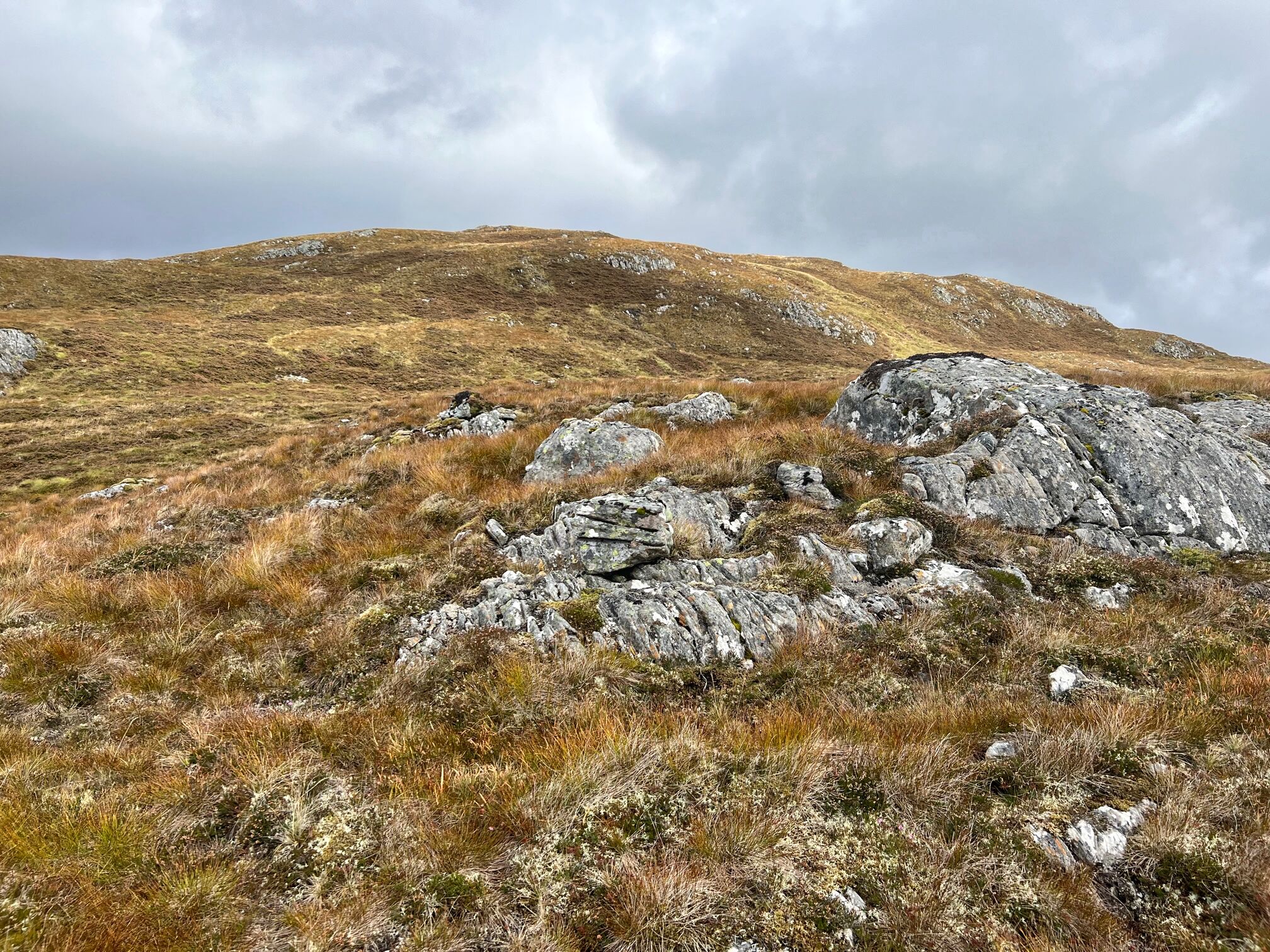
Many layers of rock, would be really interesting to know what it all represented

However there were some fascinating lumps of rock dotted about, sadly no geologists amongst us to explain what we were looking at.

When we reached the high point of the estate track we took a sharp right onto the rough ground which changed the dynamic of the ramble.

The clouds beginning to lower behind Creag na Cathaig

I had read that there was a very faint grassy track and by luck or design I found it which made these early stages easier walking across to Creag na Cathaig easier but the views down Loch Etive soon disappeared.

About to become a grey world

Before long we were in the clouds which sadly was to continue all the way to the summit, which made this section a long haul.

The track made a twisting ascent, definitely not a direct steer, but considering the terrain it was longer but fine. Regularly high lumps loomed out of the gloom, most to be bypassed, some to be tackled head on.

Our big situation was after we had ascended the minor top of Creag na Cathaig when we had a gloomy view of what was to come. We had to descend and ahead of us was a steep section of crags and wet grassy rakes. No obvious route. It was probably about 50m of ascent but it looked much more and quite challenging in these gloomy conditions.

The team doing the gully scramble. Apologies for the shaky picture.

Most of us went up the direct gully alongside the burn. Steep, wet grass, slippy rocks but we got up it and most with hindsight probably enjoyed the bit of adventure.

Another wet not so steep grassy gully took us another 100m up and thankfully we had broken the back of of the climbing when we reached the false cairn. I was aware of slight mutterings behind.

It was definitely much more technical and complicated route finding under these conditions. It is one thing to have the confidence of the GPS but when you have15 people in a line behind pressure ramps up knowing a few of them will be looking at their GPS/phone apps etc.

From the false cairn there was roughly 750m as the crow flies to the true high point (all for 6 metres of height!!).

But it was undulating terrain so you could add another 100m plus ascent to that 6m. There were no really steep sections but it was continually up and down. The wind was breezy and cold but not as strong as forecast.

As the leader I knew how far we had to go but even I was demotivated by seeing lump after lump appear out of the gloom knowing this was not the top we wanted. Naturally the group behind were having their doubts but they kept it together.

Finally the summit

Finally the point we longed for was reached and another lump appeared but the cylindrical trig could be seen, wow what relief.


There was time for a few snaps but there was nothing to see, the winds were getting stronger and everyone was feeling the cold. I knew we all needed nutrition but the group were good to go back a bit to find some shelter.

The walk back to the false cairn seemed so much much quicker and I chose to shelter for our food break beside a large section of boulders which provided a good windbreak.

Enjoyed the lunch view, the wee and big Bookle's directly ahead

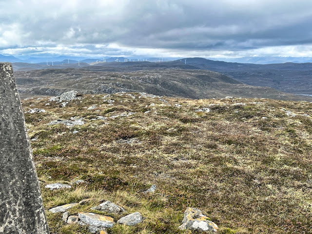
By absolute good fortune, as we sat down and got food out, the clouds lifted and we now had the outstanding views that we had hoped for. Soak it in.

Expanded view with the lump of Creag na Cathaig forefront, the descent track behind and Beinn Sgulaird on the left

It also meant that there was a clear view of our descent route but nothing seemed overly familiar due to the earlier poor visibility on the ascent. Still it was a much easier descent and for me much less stressful.

Typical terrain

In saying that I was a relieved leader when we got safely down the steep crags and made the final ascent of the day back up Creag na Cathaig. 

Ben Starav in the distance

Loch Etive with Ben Cruachan still under cloud

On the top ridge we had superb views up to Glencoe, Etive etc and morale was much higher all round. All the sights we could not see on the ascent due to the low clouds.

The faint track was regularly lost and found but no worries as we could see where we were heading but even so I was happy to reach the estate track.

Creran Bridge visible in the middle of the loch

After that it was downhill all the way, slightly spoiled by the heavy rain arriving with only about 15mins left to walk to the cars.

It was definitely a walk of two halves, a tougher outer section than I had anticipated under the poor weather conditions but overall a good group ramble.

Ascent: 984m

Distance: 17.1km

Time: 6.34

Wildlife: Raven; Common Frog

Wednesday, 20 September 2023

A big turnout for a cloudy no view summit.....Carn Mhic Toisich

Hill: Carn Mhic an Toisich (MacIntosh’s Hill)

Type: Fiona

Height: 680m


Up in Fort Augustus I wanted to continue ticking off Fiona's even though there were some good Munro outings over the weekend. So I put a couple on the walking programme where IO was prepared to be doing it by myself if no takers.

That didn't happen, 22 turned up, mainly because the weather forecast was too poor for the Munro walking so quite a gathering.

Luckily we squeezed 5 cars into the small parking area, crossed the road and headed up Eve’s Road. Well first of all we went through a pleasant old woodland a soon came across the Preachers Stones. Folklore says the preacher was mocked so he said nothing would ever grow in this spot.


Gate well hidden

Preachers Stones


Previous reports suggested this section was poorly marked but even with the high bracken the route was clear. Reached the grassy ATV track for a short section before arriving at Eve’s Road. The route roughly follows a historic path once used by Bonnie Prince Charlie back in the day. So I thought Eve might be part of the crew but nope she was the wife of the contractor who built pylons!!

Beauly-Denny Pylons

Time to go off track

We were now on the stony track which we followed up to roughly the 550m. I have to say that the pylons were less sore on the eye than I expected.

Time to cut off and go pathless over the moorland. We got to the small hill of Meall Ruigh Uislein fairly straightforwardly but then the clouds descended and visibility went from poor to not good at all. 

Some feel the cold less than others lol


Looks a lot bigger than reality

Plenty of peat hag dodging before An Suidhe appeared out of the gloom. We skirted past it knowing we were on the plateau so minimal climbing left. Another kilometre of walking. a few false tops looming out of the gloom before a larger lump appeared. It looked as if we had a big summit but the mist distorts everything and a short stony minor scramble and we were there. An old flat stone cairn marked the spot, too wet now to get the camera out but plenty of witnesses to confirm we made it.

The weather turned for the worse. Stronger winds and heavier rain. Lunch was delayed until slightly lower down on the flanks of An Suidhe.


The clouds and temperature lifted as we descended so at least the group got some local views and wet gear discarded.

Overall a good ramble that passed quickly due to the good company.

Ascent: 650m

Distance: 15.8km

Time: 5.39

Wildlife: Hare; Rabbit; Meadow Pipit

Surprisingly better underfoot than expected.....Glas-bheinne Mhor

 Hill: Glas-bheinne Mhor (Hill of the cold hill mass)

Type: Fiona

Height: 651m

After yesterdays huge turnout today numbers were back to normal with 5 of us heading for this remote Graham.

I actually had doubts about whether to include this hill as from previous walk reports and experience of its near neighbour I expected it to be a sodden boggy outing. How wrong I was it was a nice walk in 3 defined stages.

Make sure to turn sharp here or end up in Invermoriston

Thankfully a side gate

Firstly it was a long but good forested section which gained us a lot of height at a comfortable gradient, walking on a soft carpet of pine needles, very pleasant indeed. The trees were huge and it was quite dark under them with some very steep drops to the gorge below which were not for the vertigo challenged.

Our hill behind the trees, Meall Fuar-mhonaidh on right

Time to rough it

Next was a hydro track which was certainly not barren. Full foliage along the way plus a good mix of moor and trees, a typical Highland scene. More scenic than expected and quite pretty at times Only issue was stopping for a break and finding 3 ticks crawling about me, not attached, all dead now.


Reservoir with Glen Sheil in distance

Love these glacially formed rolling tops

Cairn spotted

Finally the moor section to ascend the hill. Much better underfoot than expected and a reasonable gradient to the summit. The terrain included wet moor grass tussocks and heather but in the main footage was secure. There were a few hidden water courses with deep holes. At times we had the strong smell of deer and saw fresh droppings but not the beasties themselves.

Glen Affric in distance

North to Loch Ness

Saturdays hidden hill behind the pylons

Head back to the reservoir then a track all the way back

I had read that it was a hill of many false summits but I did not really find that to be the case. Its true that you do not see the cairn until the last moment and the trig not until you have reached the cairn. Reasonable all round views, mostly long distance as nothing really close except its neighbouring fiona.

Could see the hill we were on yesterday, more than we could see then when it was in the cloud and rain.

We descended on a straighter line to re-join the track where we had a slight couple of minutes detour as I kept on the high track until error realised. Just as well as that track curved back inland nowhere near where we wanted to be.

A better than expected ramble in good company.

Ascent: 641m

Distance: 16.9km

Time: 5.53

Wildlife: Raven; Meadow Pipit; Ringlet; Blue tit


ADRC Action photos


Monday, 12 April 2021

A return to the hill of gates.....Beneraird

Hill: Beneraird

Type: Sub2k

Height: 439m

A bright Sunday morning and an outing with Ayr & District to Beneraird. I have been up this small hill once before bur started from Ballantrae so interesting to see this route. Plus the descent includes a new hill so worth a leg stretcher.

No hardship this morning taking the coastal drive with the beautiful Ayrshire coast shoreline the main view.

Nice to see a few old friends that due to Covid I have seen for quite some time.

The ramble from Ballantrae involved quite a few gates en route but this trumped it by some way. Non stop opening and closing these bulky things. 

Lovely country track
The initial stage passing an electricity power station on one side and a deforested area on the other flank not the nicest but that soon changed to a farm track. More pleasant and lots of sheep but thankfully most were a distance from us so no disturbance.

After a short pleasant stroll, albeit in light snow for a spell, we reached the junction of my previous route.

The group get a lecture from Sheila on hut circles
We took some time to look at the area of ground where three hut circles are marked on the OS map. 

Old tyres good for something
I don't think that the mound of old tyres were their remains but there were three identifiable raised mounds that matched the OS locations. 

Hut circle ground with mounds 2 & 3 just ahead
No doubt some aerial x ray photography would show them up in detail but using your imagination the mounds cold be the locations of three separate Crannog style structures.

Beneraird trig ahead
Onwards up the straightforward track until Beneraird is reached. 

Look one direction and snow showers dominate
Fabulous views albeit the Awful Hand seemed to be on a constant winter weather front, lots of white stuff for anyone walking these today.

Look the other way & blue skies
However we had superb views over Arran with the Paps of Jura a stand out from this angle. Ailsa Craig and the Mull of Kintyre behind. Even Ireland's coastline is clear today, the clear winter air letting us see as far as our eyes and the horizon allows.

Ruined vehicle still here, Smyreton ahead
The windchill was too cold for a lunch break here so a stroll back down the track to find some shelter before we headed for Smyreton Hill.

Wall is the windbreak for lunch
This section was pathless over typical moorland terrain. Not overly challenging as the ground is so dry. The biggest hazard barbed wire fencing, more blood drawn. These do not agree with me.

Last moor crossing
Still enjoyable views as we headed for the mast at Auchencrosh Hill. Following faint paths, most likely animal tracks but when found they helped the walking.

Finally the maintenance track back to the main road and a short walk back to the cars. Fresh coo pats but never spotted the beasties themselves.

A short but enjoyable day, dry and a sun/weather skelped face, glad I put on some sun lotion. Plenty of chat with old and new. Almost seems normal! Only disappointment minimal wildlife but that's group walking for you. I had hoped for an early cuckoo but not to be, hopefully soon.

Ascent: 523m

Distance: 14.5km

Time: 4.24

Wildlife: Raven; Skylark; Meadow Pipit