Showing posts with label Dumfries & Galloway. Show all posts

Tuesday, 6 August 2024

A delightful walk.....Sandgreen Bay

 Walk: Gatehouse of Fleet - Sandgreen Bay
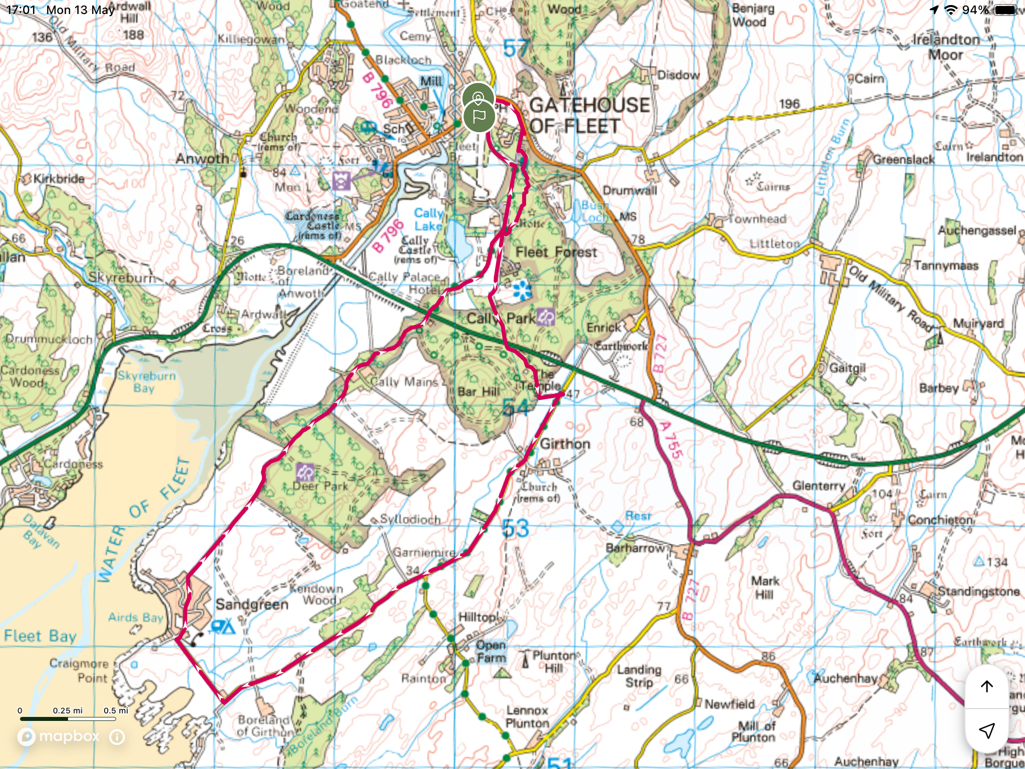

The good lady was at an arty workshop so I took advantage of the good weather to do this circular walk. No hills involved but I absolutely loved it. I did the walk clockwise but either way fine. 

Stunning woodland pity you cannot hear the non stop singing of the spring birds

The ruined Temple

My ramble started by going through the Caley Palace woods which were alive with singing birds, a magical place today.

Interesting water level board at the side of the road! Any information on why this is here would be welcomed.

The old church ruins at Girthon. This structure was built on top of another church estimated first established in the 13th century.

There is some road walking but it is so devoid of traffic that the feeling of peaceful countryside dominated.


Him

or Him?

Then cutting along to Sandgreen Bay where I encountered the testosterone bulls. I was far away wondering what this low level rumbling noise was. Then I spotted five bulls in the field and the noise was coming from two of them who were having an alpha male encounter. Watched for around 10 minutes, the body language of the two was fascinating as was the body behavior of the other three bulls who were clearly agitated.

A beautiful bay with the D&G coast a standout. The bay has a large caravan park surrounding it and as you would expect water sports dominate. As I walked through the caravan park boats, canoes and other sea sport items were plentiful.


Turned around and headed back into the forest with outstanding scenery including the stunning bluebell woods and running water.

So warm it was great. If your in the area I strongly recommend this ramble.

After all that energy expended it is time for a pint sitting outdoors at the Masonic Arms in the spring sunshine, bliss.  

Ascent: 93m

Distance: 14.42km

Time: 4 hours

Monday, 15 July 2024

Three tops to get one tick.....Tarfessock South Top

Hill: Tarfessock South Top (via Shalloch on Minnoch & Tarfessock)

Type: Donald Top

Height: 610m


The Ayr OiR were out out today for a short up and down of the Corbett Shalloch on Minnoch. This is a straightforward walk but with good weather conditions I decided to join them but go a bit further and knock off the Donald Top of Tarfessock South. My planning for my summer walks had me doing this from the Kirriereoch parking area but although this was a longer walk it was too good to miss to do it today plus I would have company for part of it.


As we geared up at the Stinchar Falls parking area it was great to hear a Cuckoo full on calling. I have had two brief encounters with the bird this year but this was the first full calling experience, sadly still to see one.

Ten of us set off up the usual route to Shalloch, extremely boggy, accompanied by the singing Skylarks and Meadow Pipits, presumably mocking us as well as attracting a mate.

Final ascent to Shalloch summit


The way forward

Plucked male Wheatear

My partners coming up Tarfessock

At the cairn at the top of Shalloch five of the group decided to descend and four sad soles came with me to Tarfessock. A rough pathless descent of about 100m followed by an ascent of circa 50m found us at the top of Tarfessock. A cooler stronger breeze got up but still good viewing over this very rough and rugged landscape.

Spot the south top summit?

The crags mark the spot

Rough ground

Now for the return, Tarfessock first then Shalloch behind it

A brief lunch stop for me, longer for the others, before I went solo to Tarfessock top. Now it was unknown territory and a new section of the Awful Hand for me. From up top I could see the objective but I was surprised by how awkward the descent was. Rough ground, craggy tops to be rounded before reaching a boggy section. A trail of sorts and I was at the small cairn, better than many full Donalds I might add.

I had completed a flat walk of 15 miles yesterday so my legs were a tad weary. As such the albeit short re-ascents of Tarfessock and Shalloch were more intimidating than they should have been.

The shortest, but steepest section back up to Tarfessock was the worst, no path, tussocky ground, rounding crags, aching muscles but then I was there.


4 climbing the slopes of Shalloch

Looking ahead I could see my four companions were about two thirds of the way up Shalloch. I wish I was with them but would I catch up with them?


Clouds about to come down to my level

On the way up Shalloch I kind of lost the track and ended up just hiking straight up the straightforward but steep slopes until I reached the plateau and spotted the cairn further away than I expected but at least the terrain was flat and good going.

Now homeward bound but the descent was much more awkward than the ascent. Maybe because the ascent is slower and you are picking the route more carefully. On the descent I was rocking and rolling all over the place no consistent footing. I seemed to be plunging into boggy patch after boggy patch, it was horrible and very tiring.

At least the cuckoo was still calling, obviously no females around or not interested. At the small waterfalls a red squirrel crossed towards the trees, it was moving slowly. Delighted at my first sighting of the year but I suspect all was not well with it.

A good ramble in fine company, a new hill bagged, what's not to like.

Ascent: 845m

Distance: 17.01

Time: 5.22

Wildlife: Meadow Pipit; Skylark; Wheatear; Cuckoo (heard); Willow Warbler (heard); Red Squirrel (1st of the year)

Tuesday, 26 December 2023

Final Galloway Sub2k.....Pibble Hill

Hill: Pibble Hill

Type: Sub2k

Height: 383m


Woke up to a rare blue sky day, was meant to be doing something else but this weather opening could not be wasted. As it was a last minute decision a short walk was required. Ferries were still a bit erratic after last two days of stormy weather so a short trip to the Galloway Hills to finish my last of the South Western Sub2k’s.

Lovely drive which took longer as I was going slowly trying hard to avoid the potholes hidden at times by the very low glare of the morning sun.

Made it and parked up on the obvious grassy area on the Corse of Slakes Road close to the maintenance road for the masts on Cambret Hill. 

On stepping out of the car I was met by a bitterly cold wind, wow not used to this. Hat and jacket on immediately and gloves donned at start of walk, long time since I did that. From the car I had a clear view of where I was heading over rugged and barren Glenquicken Moor. I suspected a small hill that I could see in the distance, slightly right and behind the main ones had a point on it, was that Pibble?

Although this is a short ramble I had always chosen something else over it due to its reputation as being a moorland bog fest. The reality? Well in parts it definitely was but considering the amount of rain we have had recently it was was much better than expected.

Typical pathless D&G moorland

View over barren ground Gatehouse about 4 miles thataway

Ahead lay a sprawling typical D&G moorland. From the car there was a faint ATV track that I could see so started with it which disappeared just as quickly. These were proper foot rolling tussocks but on the out ramble I picked my way quite well using on off ATV tracks and water tracks which at least gave flatter non ankle rolling walking. Don t expect to go in a straight line just meander as your eye sees best.

Keep the wall on the left

Cairnsmore of Fleet in background

Any ascents are gentle I just kept heading to the higher ground looking for harder surfaces. They were there but higher up more defined ATV tracks could be followed for longer but surprisingly these were also the wettest bits.

I reached the ‘high’ ridge where to be fair the wind was stronger and cooler. But the views were good particularly over Cairnsmore of Fleet.

Very little wildlife so far a solitary meadow pipit and solitary raven.

Final humps and tumps

The hill I could see from the car was very close and it did indeed have a pointed stone cairn, an easy 55 minutes from the car. The stone is a thin whinstone with a larger example alongside some flat stones in the woods. This area has many historical sites and this could well be another one.

View to Cairnsmore of Fleet and mine over that wall

View north

View south

Zoomed in and Lake District hills at top

As I said earlier the views over Fleet excellent, viewing south the rugged moorland dominates and the Lake District hills are just obvious in the haze.

As I stood at the summit looking northwest there is an abandoned copper/lead mine on the slopes on your left, not visible from here. You can go up a track from Creetown to this historically important mine worth a short read Pibble Mine - Northern Mine Research Society (nmrs.org.uk)

Return route masts just seen on Cambret on the left. No snaps after this due to low sun and glare

Returned the same way along the upper level with the masts on Cambret Hill a straightforward navigational guide.

After that I was aware that I was varying my route slightly and although not far away from the ascent this section was much wetter and harder to pick a line in the tussocks so just aimed for the car. One plus was springing a snipe zig zagging away with its unmistakable weird call.

So a gentle ramble to finish my SW Sub2k’s. These are hills that get sparse visitors and all the better for it. Very pleased I did it today with the blue skies and the long distance views.

Ascent: 206m

Distance: 5k

Time: 1.45

Wildlife: Snipe; Raven; Meadow Pipit

Tuesday, 5 December 2023

Grey ramble on.....Bengray

Hill: Bengray

Type: Sub2k

Height: 366m


Its raining, its pouring, as the saying goes, but today might stay dry before it is all returning tomorrow.

I hadn't planned to go out today but after watching Judith the weather on the BBC app, whilst snuggled under the duvet, I decided to go for it.

Judith forecast that ‘almost’ all of the country was going to have a beautiful day, full of late year sun and great views.

A short outing was required. I drove heading south into the glare of the low sun moaning that I should have gone north with the sun behind me.

However, it did not take long before I began to doubt the wisdom of heading south, not because of the glare but when reaching Patna I was in full mist and fog conditions, trying to remember where the fog lights were in this car, yip it was that bad.

Above Loch Doon optimism rose again as although the lower levels were still shrouded I had risen above it and if one was on these hills a grand inversion.

On the descent to Carsphairn everything went downhill, not just the pot holed road but the lack of visibility. It couldn't stay like this could it? I watched Judith tease me on the map, no clouds to be seen down here.

Thought it was clearing at start but wrong

When I arrived at the start it was indeed no joke slightly clear with limited visibility ahead. A consequence of quickly throwing gear together was about half way on the drive I realised that I had left my GPS at home and had not brought a map. Luckily I had a signal and opened the OS map on my phone, drew a few straight lines that would bear little reality to the actual ramble but at least I had a map.

Last time I drove past the starting point there were coos everywhere but today they seemed to be congregated around the feeders on the other side of the road. 

The walk starts via a signpost for Loch Whinyeon so I followed that track for a short spell. The huge deposits on the track indicated the coos might still be around.

Was still optimistic

Over a very slippery wooden style and followed the track for a bit before making a decision to head off across the moor towards Benfadyeon. 

Then this for most of ascent

With theses misty conditions the hills and hummocks appeared with the distortion of being much larger than they were. I was on the pathless moorland heading for the highest top that I could see and when reached of course another one appeared. According to the map it should have been a relatively flat walk from Benfadyeon to point 272 and beyond. But on the rough moor it did not feel like it.

Taken on way down ATV track I stumbled across far left

After point 272 I crossed a broken stone wall and stumbled across an ATV track which would take me to point 362. Wet and boggy in places but much better than the moor.

Final top getting closer

The summit top is only 4 metres higher than this point and it is not far away. It was only whilst looking around that I remembered walk reports mentioning a barbed wire fence and I was looking at it. I had changed rucksacks and emptied this one to find my covering for an assault over barb wire, yipee.


A scramble over with a slight tearing sound, inside trouser leg, minor damage. Between here and the trig was by far the worst of the going and that says a lot but 5 minutes later I was at the trig. Sadly nae views.


Stumbled back towards where the fence was and a bit of luck, I was further over and found a section with the barbed wire cut at NX 629598

Feeling good at crossing the fence without more damage I was even happier when I a couple of stags started calling. In this mist they could have been anywhere but it sounded like they were south of me.

Started to lift on descent but came down again just as quickly

Far side still in cloud

I followed the ATV track and initially the mist lifted giving me some views re where I was heading. It was not long before the clouds descended again. I followed the ATV for longer before the brain warned me it was going south of where I wanted to be. No big deal as I would have reached the loch at some point. I took it as far as I could to shorten the moorland section which was a good decision. At one point, a Woodcock just about gave me a heart attack it literally stayed hidden until I almost stepped on it.

Bird on left best profile

Slightly better viewing on the final section. The hills across cleared and I was amazed and delighted to see a pair of birds making wide effortless circles, going higher and higher in the thermal they had found. Huge wingspans no doubting the sighting. They have released over 40 birds as part of the Moffat programme so they must be spreading all over the South of Scotland seeking out their own territories. So despite the weather what an end to the ramble, thanks Judith.


Ascent: 288m

Distance: 5.11km

Time: 2.11

Wildlife: Golden Eaglex2; Red Grouse; Meadow Pipit; Woodcock; Red Deer Stag calling

Monday, 31 July 2023

On yer bike.....Keogh Rig & Dugland

Hill: Keogh Rig (611m) & Dugland (608m)

Type: Donald Tops


I wanted a bike ride today with the attraction of the 1st time in weeks the wind was light and there might even be some blue skies. I was bored cycling from home, same old route starts etc so got the notion to cycle up Windy standard and tick off two of the Donald tops still on my to-do list.

When I arrived in Glen Afton the Blackcraig side was gloomy and dark whereas the Windy side was a mix of blue sky and white clouds, which would prevail.

I parked at Blackcraig farm to make the ride a bit longer but annoyingly the beasties were already buzzing about my head, hopefully cycling would keep them away. 3 or 4 agitated Jays were calling and moving in the nearby trees. A pair of buzzards were gliding slowly over the tree tops, maybe the Jays they fancied for breakfast.

I joined the wind farm track to find workies erecting a new substantial gate that did not appear to have a side gate for cyclists/walkers. They said they were told to just leave a wee gap at the side!!

Windy Standard but a weaving route to get there
Not a lot to say about a cycle ride. I was glad I was on the bike as it is a fairly boring walk up the construction road all the way to Windy Standard. I was however glad I had the ebike as some of the ascents were distinctly tough for my fitness level and now not fit enough to do them manually.
Follow the grassy track

Keogh Rig high point of the hump

From the turbine Cairnsmore of Carsphairn & Beninner

Looking over to Windy Standard from the 'impressive' summit marker, a feature of the Donalds

Nicer view Deils putting stone and a nice grasst valley, what once was!
At Windy Standard it was windy and cool enough for me to don a light jacket. I secured the bike to a pylons stairs and set off on foot to Keogh Rig. I had originally planned this as a bike hike from the Moorbrock Hill side but as I was up here anyway it was vjust as easy from this side. I followed a grassy ATV track beside a fence descending to the lower turbines, a bit wet and boggy but fine going. At the turbine I followed the construction road to another pylon and crossed the rough ground to find the single wooden stake marking the top of Keogh Rig. The view was nice if the turbines were omitted. Excitement over I retraced my steps back up the same way and spotted the Deil’s putting stone which I had missed on the descent.
Bike still attached, Windy Standard behind

Dugland between the two pylons on the left

Dugland cairn looking back to Windy Standard

View from Dugland cairn to Moorbrock Hill on left & Green Hill on right

Glad to find my bike still attached to the turbine I set off to the up and down roller-coaster ride to Dugland. More turbines to find the correct turn to take. From the viewpoint above I thought my target of Dugland Hill was beside the turbine not moving and I was correct. Chatted to a maintenance worker who was trying to get it moving before making the short crossing to the top of Dugland, marked by a small cairn.

On the way back to the Windy Standard track I missed the turning but thankfully realised my mistake before I had gone too far. There is definitely more climbing this side and my legs were feeling the efforts.

Then it was the mainly very fast descent back to the start. Eyes popping, vision blurred, it was fast and fun, adrenalin was running. I remembered just in time two drainage ditches which I had to bunny hop, could have been a nasty incident if I had rode into one of them but got down safely. On another fast descent a beautiful chestnut brown roe deer stag jumped across the track, another one further on, female this time. Definitely did not want to hit them. It was not all downhill as a few uphill stingers are thrown in, I was trying to ride the bike as a normal MTB as often as I could but the battery power was certainly turned on quite a few times.

Back to find the workies at the much more sturdy gate than its predecessor. There was a small area to pass it, fine for walkers a bit more awkward to push a bike through.

Overall it was a blast, two new Donald tops bagged and a real adrenalin high that walking alone cannot give. There was still plenty of time to take in the views. But the bike meant I was not out for a long day, I will be doing more of this.

Interesting anecdote. Back at the car I checked my watch for the stats and was surprised to find the distance in kilometres as I always have it set to miles. Back home I plugged my GPS into the PC to find the distance was also in kilometres when it is set to miles, weird!!

Ascent: 949m

Distance: 22.61m

Time: 3.21

Wildlife: Buzzard; Jay; Meadow Pipit; Tree Pipit; Chaffinch; Roe Deer: Orange Tip,