Showing posts with label Fife. Show all posts

Monday, 16 March 2020

Three wee Fifers completed the set

Hill: Norman’s Law; Mount Hill; Cairney Hill
Category: All Sub2K
Height: n/a

I was visiting the Kingdom of Fife for a few days with the good lady. Today the good lady opted for an active session touring the shops in St Andrews, always keen to spend her pocket money. Trying hard not to smile too much I thought that this was a fab idea as it allowed me to head for the small hills of Fife and complete my Fife Sub2k’s. It also helped that today was forecast to be the only blue sky day of the trip. Despite it being Friday 13th I braved the traffic and headed to my first hill of the day Norman’s Law.
Norman's Law
Reports for a couple of hills I was completing today said they were mud fests so I used wellies today. Both a good and bad idea.
I started from the quaint village of Luthrie and headed up alongside a working farm whose byres were still full of cattle. There was a surprising and disconcerting notice pinned at the end of one of the byres ‘casualty evacuation point’, is this a battle ground?
It is a straightforward walk until I reached the old farm building which is currently being refurbished and the track is over towards a building where farm and workers vehicles are conveniently parked hiding the signs, deliberate or what?

I reached a point where I had the option of going directly up the hill or to circuit it and come back down the obvious track. I opted for the circuit route and wellies were definitely an asset for plodding through the coo trodden muck. Not a section to slip and fall in!!
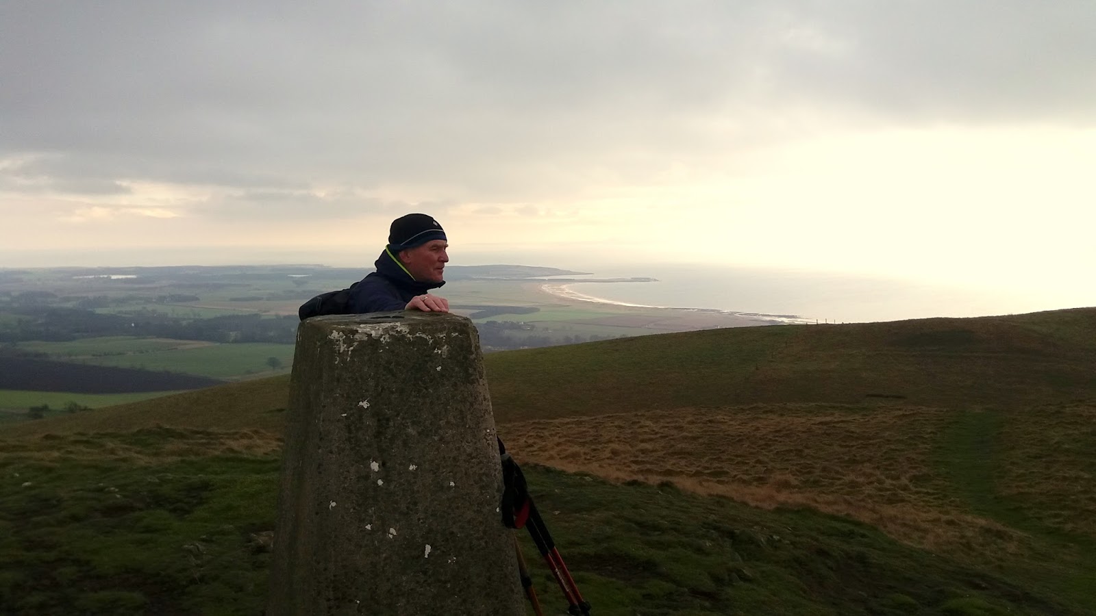
A cairn rockpile, a trig and a viewfinder
A short climb winds it way to the top of Norman's Law which surprisingly includes a trig, a cairn and a description board, not bad for a wee hill. It is another ancient hill fort, no wonder with this vista.
Viewfinder looking over to Dundee
The views are superb particularly locally looking down on the Tay estuary and the bridge to Dundee. Further north all the Angus and Perthshire big hills are well covered in snow.
It looks benign but muddy slips coming up

On the descent the wellies get payback, they are old, minimal grip meant a couple of heel slips, pain and muddy clothes along with a few sweary words. You can continue through the field of cows for a slightly longer circuit but as I wanted the three completed today I just backtracked.
Cairney Hill track to the right
Number one done so next it was off to Cairney Hill which is situated beside Lindores Loch, only a short drive away.
The top is in the trees straight ahead
Here a shooting track takes me all the way to the undistinguished top. At least the track is original format of mud and grass and not the modern motorway construction on some estates.
Deer shooting platform
Enclosed at the top alongside the tree line is a shooting platform, obviously not just the pheasants that get blasted here.
Just a couple of minutes later surprisingly for us all, I disturbed a pair of said roe deer, almost coming face to face behind a gorse bush, the wind in my favour. Just as quick they scarper after seeing me.
The stone marks the spot
The top is just as forgettable as the ascent, I head briefly through the undergrowth to find a stone which marks the summit spot. Not a place people would come to unless by accident or bagging
However back to the track and there is decent view of the Fife countryside including the other two hills on today’s trip which are in clear sight.
Back down the same way to enjoy my lunch, a fudge doughnut. Nobody but nobody makes these as good as Fisher & Donaldson. If you have never had one it should be on your bucket list, shops in Cupar & St Andrews. 
Hopetoun monument peeks out of treeline
Now off to the last hill for today, another little Sub2k oddball which has a folly at the top, the Hopetoun monument is Mount Hill‘s claim to fame. It can be seen for miles around.
A straightforward right of way takes you from the farm entrance to the summit. Muddy trail again wellies quids in once again despite slipping and sliding all over, like a fat Bambi on ice!
Nothing too inspirational other than listening to and spotting the birdies in the tree tops until you reach the top. 
The gate is easier than climbing
The folly is surrounded by a very large deer fence, gate padlocked. Some reports say climb it but it is high and loose. A better option is to continue up the bog fest until you reach another gate which this time opens. 
Mount Hill trig
Now you get both the monument and a trig. Why the trig is necessary when it is overshadowed by the huge monument. If you have the money why not.
Back the same way to the car.
Three small hills, an interesting day in good but cold weather. No more Fife hills to bag so time for some real ale. There are plenty of micro breweries around here so looking forward to a good evening.
Another good rambling day but a slight grey cloud as I drive back wondering what damage the credit card has taken?


Wildlife: Coal tit; Blue tit; Great tit; Long tailed tit; Grey squirrel; Roe deer; Blackbird; Buzzard; Robin; Pheasant; Kestrel; Carrion Crow; Yellowhammer; Woodpigeon; Wren; Ladybird (1st this year).
Time: 3.33
Ascent: 589m
Distance: 13.9km


Thursday, 17 October 2019

Dumglow

Hill: Dumglow
Category: Sub2k
Height: 379m

A short drive from Benarty Hill and although weather not brilliant, rain threatening clouds, I decided to start the walk anyway.
As this was a last minute change of plan I had not prepared a route. However, I had studied online, one persons walk this morning and had the map ingrained in the old memory banks. My only concern was the route going through a very marshy section of reeds and with all this rain it was going to be very wet. Some mentioned almost impassable at times.
My starting point
The walk report had mentioned parking at a lay by with the signpost to Dumglow. That’s what I did and started walking up the track. This was clearly a forestry road and one report said it was a short walk to the Loch an Glow, less than a mile it said.
Apparently a lookout point for the big fort
I came across a family with dogs who said the path was a dead end at one point but they had not gone further. No problem, route etched in mind and navigation should be straightforward, terrain excepting.
Not my water where is that loch?
I reached a junction yellow marker sign, good but I was now well over a mile into the walk and still no sign of the water!! Deforestation all around I should see the stuff.

I continued until this temporary forestry track became a dead end but there was also a signpost. The loch ¾ of a mile away in one direction but Dumglow just half a mile through the woods. The loch is a well known fishing water and no way the anglers were walking 3/4 of a mile from here with all their gear. I was certain that I had not missed any turn offs then the grey matter kicked in there must be another lay by further on from where I parked!
Muddy track walk on the green left and ankle deep
Undeterred I followed the way to Dumglow and entered the woods, a bit more awkward as it was a very boggy area but the odd footprint in the mud suggested I was not the first person up here recently.
Head through here
I then came to a full on wood tunnel, a flicker of light at the end. Well I was here now so on I went, glad the good lady had passed.
Out onto the open moor and I could see said loch down to my left and in front of me a grassy path continuing up hill. 
Looking back from style the fishing water
I followed this, over a fence and up a small grassy hump and there it was, the trig not too far away. A short saunter and the top of Dumglow was reached, another hill fort.
The Ochils from the trig
Obviously another excellent viewing spot The Ochil hills not in cloud today. Back towards Loch Leven the hills also cloud free, I got lucky with the weather.
That's a big new house
There looked like a very large new build being constructed down below, nice one.
Back through the woods and a goshawk glides near the tops before right angling into the trees, an impressive fast turn and the birds have stopped singing!
So, it turned out that my route was the shortest and easiest walking route to get here after all. Maybe not the most scenic but a lucky break avoiding the loch side pathless trek. At the parking area a new plantation and a large flock of tiny Goldcrests moving through, lovely birds, a good ending to the walk.

Wildlife: Goshawk; Goldcrest; Buzzard; Jay; Wood Pigeon; Meadow Pipit; 
Time: 1.21
Ascent: 576ft 
Distance: 3.51m 

Benarty Hill

Hill: Benarty Hill
Category: Sub2k
Height: 356m
What a difference a day makes, after yesterdays perfect viewing conditions I woke up to a misty damp morning. I was originally planning a moorland hike but opted to head across to Fife and do at least one of the easy lower Sub2k‘s I had been keeping for the good lady.
Good network of paths
By the time I reached the start there was blue sky above but still low cloud looking back to the Pentland Hills. There seems to be a good network of walks around here. Possibly to do with the economic deprivation of the ex mining area trying to get people active.
Good steps go up a fair way
I started by heading up the wooden steps heading into the trees. By golly this was steep going but the birds were singing as if it was spring so just keep going. 
At the point where this path meets the one from Ballingry there are good views back to Loch Ore. There seems to be a lot of cars parked maybe it is an outdoor centre?
Turn left here and follow the path still in the trees but deforestation can be spotted ahead.
On track now out on the moor
There is now a main forestry path and numerous others zig zagging through the ruins, I just kept following the widest one. That was until I suspected this was going the wrong way. I had glimpsed a fence gate higher up in dead tree land so I backtracked and yes this was the one, very easy to miss.
Squashed round stone
A good path again to reach the big round stone and the trig point can be seen in the distance. It was warm and I was perspiring.
Trig looking to Bishop Hill
 The path winds it's way across the moor and goes right to the trig but go further, over the fence and stand at the edge. The views are absolutely cracking as you stand and look down on the wide expanse of Loch Leven and the surrounding flat lands farmed by the RSPB at Vane farm. Looks great from here but not good memories of fishing there. 
Scotlandwell and Bishop Hill
Behind Loch Leven lies the village of Scotlandwell and Bishop Hill which I was up earlier this year. 
Glider getting towed up
A glider is being pulled up and a huge flock of greylag geese fly over, easily a couple of hundred. The circle the loch for ages before swooping down to rest and feed.
Loch Leven
It is not a hardship to stand here and soak it in. The only downside was over to the West the other hill I was considering is still in cloud.
Across the way the landscape is clearly not natural and is the terrain of an Iron age fort. Probably better seen from above, reminder check Google Earth.
On my way down a kestrel hovers. Not sure if I have just been lucky or are they getting numbers back but I have seen a good few across Scotland over the last few months, long may it continue.
Finally all over, a grand wee walk with once again beautiful views for minimal effort. I will head over to Dumglow and see what it is like.

Wildlife: Tits-blue, coal & great; Kestrel; Carrion crow; Jackdaw flock (over 50); Greylag geese.

Time: 1.16
Ascent: 644ft 
Distance: 2.29m 

Sunday, 24 February 2019

A popular Bishop

On my way up to Perthshire to have another cast or two for spring salmon I took the opportunity to tick off another sub 2k.
The forecast was for low cloud all day but as I approached Scotlandwell the light was bright to the south but the Bishop hill in cloud, which would win?
As per intentions I followed the WH circular route from Scotlandwell.
Portmaoak kirk
Only a couple of cars in the church car park so no funerals today or a small turnout for the deceased 
Crossed the road and followed the footpath sign  for Kinnesswood and Bishop hill. A pleasant wooded area the normal Spring birds singing away, robin, thrush, blackbird etc.
Another one of those days for some reason breathing a bit laboured, legs feeling tired, no drink for ages what is happening to my body, old age I presume.
Low flying
As I exited the woods a noise made me look up as a glider soared above, a buzzard in between us. The airfield can now be seen below. I would have thought the cloud to low but there you go.
Just before I reached the open moorland I met two different people descending, tried to look non sweaty and failed. The lady said it was clearing up top, didn't look it from here. It was a stiff wee pull up.
Open moor Bishop Hill in cloud
On the open moorland plenty of fresh cowpats, as it turned out I followed their pats and churned ground all the way round but never saw them. What I did see was my first skylarks of the year rising out of the gloom in pairs singing away.
Well into cloud now so just following the coo trail and the odd glance at gps to small cairn of Bishop hill. 
Spot the top before the cloud covers it again
A few hill runners around, not fit enough for that and also a few other walkers, surprised I thought I would have this to myself today but no, a popular Bishop indeed.
No hanging about here
No point in lingering at the summit, nae views, so just followed the gps round and started the resent. Came across a flock of sheep but still nae coos.
For 30 seconds a view of Loch Leven

From the odd gap in the clouds the potential of the views can be glimpsed. Sadly it disappeared just as quickly.
This cut off was easy to miss
There are a few cut offs, presumably down steep crags, so glad I had the gps working as I followed the correct route by turning right down right angled path, easy to miss in the clouds, which descended grassy ground in a slight dip to reach the top of some crags.
Steep and slippy
 Turned left here until the path led down a steep gully between the rocks. I descended with care but paused a few times as the views were opening up. Good track but eroded, muddy and slippy, continued down the the grassy path until some utilities building are reached just above the village with a way marker post to guide you. The sound of the kids playing footie in the school below sounds much closer.
Looking back to descent
Turned left onto a path with a fence on your right. This path undulated across the hillside. Ignore a gate on the right to golf course, looks like an up and down golf course a bit tight as well, the coo pats still led the way. Continued along path until it enters Kilmagad Wood via another gate. The path now continues through the woodland until it meets the outward route.
A short walk and glad I stretched the legs.
Needless to say that when I was back on the motorway to Perth, as I passed Bishop Hill the trig was in clear sight, Sod's law.
Robin, black ie, thrush, blue tit, carrion crow, woodpecker, skylark, buzzard

Sunday, 22 July 2018

The Lomond Hills

I had a change of plan today from my original 3 Moorfoot Donald’s to 2 Fife Sub 2000’s. In reality this was a good choice as it was sweltering hot and my legs were just not on it today.
I also did these the easy way firstly copping out by driving up to the East Lomond car park. 
An interesting notice board to spend some time reading re the history of the hill as a fortress, artefacts that have been discovered and no wonder with this vantage point. 
A few people around already eating at tables, tourists? 
East Lomond viewfinder looking towards West Lomond
Then simply a case of a short walk up to the summit of East Lomond 380m. Delighted to see a kestrel hovering, a rare sight these days. Despite its short stature it commands open views for far and wide.
Falkland below
What views despite the warm air. As the plaque points out a multitude of hills, Schiehallion’s point is clear, Lochnagar is in sight, a conquest from a few weeks ago but I will have to take the direction indicator‘s word.
Back down and a not easy trip to the Cairnsmede parking area, sat nav would not recognise it. In Falkland, no signage so I resorted to Google maps which did the trick and got me there.
As soon as I left the woods East Lomond is very close behind but I am heading the other way across the moor. A straightforward trudge along a well maintained track where a surprisingly wet peat hag was evident.
West Lomond
In this prolong heat every other one on bigger hills have dried up. Continuing this track until I reach the base. The track goes left and maybe winds round it but there is a direct path carved out by a few walkers.
West Lomond trig
It is a short sharp ascent, there a few people resting about half way up.
Protesting calves got me to the trig of West Lomond, 522m, higher than its close neighbour. The trig was covered everywhere by a very large swarm of wasps who were angrily buzzing around it and the nearby rocks. Not the place to take lunch.
Looking back to East Lomond
Fortunately a few good spots nearby and even better views of the distant hills as well as the lush Fife countryside and Loch Leven. I remember fishing it on a day like this, nothing moved or was caught.
Just a great 360 panorama to enjoy with my banana and crisps. All the way to Tinto in the south, Berwick Law, the Firth of Forth and the northern hills, too many for me to identify.

Apart from the wasps, a couple of pipits, a few butterflies and a young hare was all on show here.
A short warm hike back to the car, as said that was enough for today.

Combined stats.
Time:
Ascent:
Distance:

Sunday, 5 February 2017

Largo Law


Another Hugh completed for Mrs B today. Spending some time in Fife and after a wet early morning the weather relented so we hit the nearest hill in the book which was Lower Largo.
The hardest part initially was finding the small cut off from Lower to Upper Largo to get to the start. We could see the grassy track going up the hill but the farm we passed had a sign no entry to hill, a debate with the sat nav and the cemetery car park was found.
On the face of it this should have been a similar walk to Knockdolian last week but it is different. Firstly, the walk in is the muddiest, gloopiest farm track that I have walked, real horrible stuff. I suspect the farmer does this deliberately to discourage walkers.

Secondly, the hill is a steeper climb than last week, not tough for anybody fit BUT. The big but is the broad grassy path was extremely muddy and very, very slippy. Combine the steepness with the non existent grip Mrs B found it challenging. Under normal circumstances I would not have considered walking poles for such a small hill but thankfully we took them. Each step was a case of forcing them into the ground to anchor you before stepping up. Like walking on ice.
The easier mud track
However to the hill. There is a sign warning that dogs must be on lead at this time of the year, none allowed March - November, as cattle normally on the hill. Thankfully there were none today, just some sheep. Once past the farm track mud continues until you get past the fields containing horses. Weave through some gorse bushes then there is the clear but eroded path up to the first top. Going up the second climb the erosion is not so bad.

Once this has been topped the trig is in sight. Take some time to take in the views. A short descent, cross an electrified fence at the broken stile and after another short ascent you are there. In fact all of the stiles we used were badly broken.

Once again the Hugh did not disappoint. Even in these conditions the views all around are excellent, particularly on the Forth side, the beaches of Elie and Lundin Links showing well, must be low tide to see so much sand. However, East Lomond can barely be seen, looks like it is still raining over there.

On the very slow way down Mrs B did slip, ending up with muddy gear but thankfully no injuries. Then 3 guys appeared near the bottom, Polish I think from the brief chat with one of them, no walking gear, training shoes, they were going to have some fun descending.
View towards Elie, Bass rock in background
Not a lot of wildlife around today, a kestrel hovering up the top. Something flew low and fast but too far away to identify, merlin or sparrowhawk, plus a raven doing some fab aerial acrobatics.

50 minutes up and 30 descending, 221 metres of ascent, ready for a coffee and cake somewhere but despite the mud still a good Sunday walk.