Showing posts with label The Hughs. Show all posts

Thursday, 17 October 2019

Benarty Hill

Hill: Benarty Hill
Category: Sub2k
Height: 356m
What a difference a day makes, after yesterdays perfect viewing conditions I woke up to a misty damp morning. I was originally planning a moorland hike but opted to head across to Fife and do at least one of the easy lower Sub2k‘s I had been keeping for the good lady.
Good network of paths
By the time I reached the start there was blue sky above but still low cloud looking back to the Pentland Hills. There seems to be a good network of walks around here. Possibly to do with the economic deprivation of the ex mining area trying to get people active.
Good steps go up a fair way
I started by heading up the wooden steps heading into the trees. By golly this was steep going but the birds were singing as if it was spring so just keep going. 
At the point where this path meets the one from Ballingry there are good views back to Loch Ore. There seems to be a lot of cars parked maybe it is an outdoor centre?
Turn left here and follow the path still in the trees but deforestation can be spotted ahead.
On track now out on the moor
There is now a main forestry path and numerous others zig zagging through the ruins, I just kept following the widest one. That was until I suspected this was going the wrong way. I had glimpsed a fence gate higher up in dead tree land so I backtracked and yes this was the one, very easy to miss.
Squashed round stone
A good path again to reach the big round stone and the trig point can be seen in the distance. It was warm and I was perspiring.
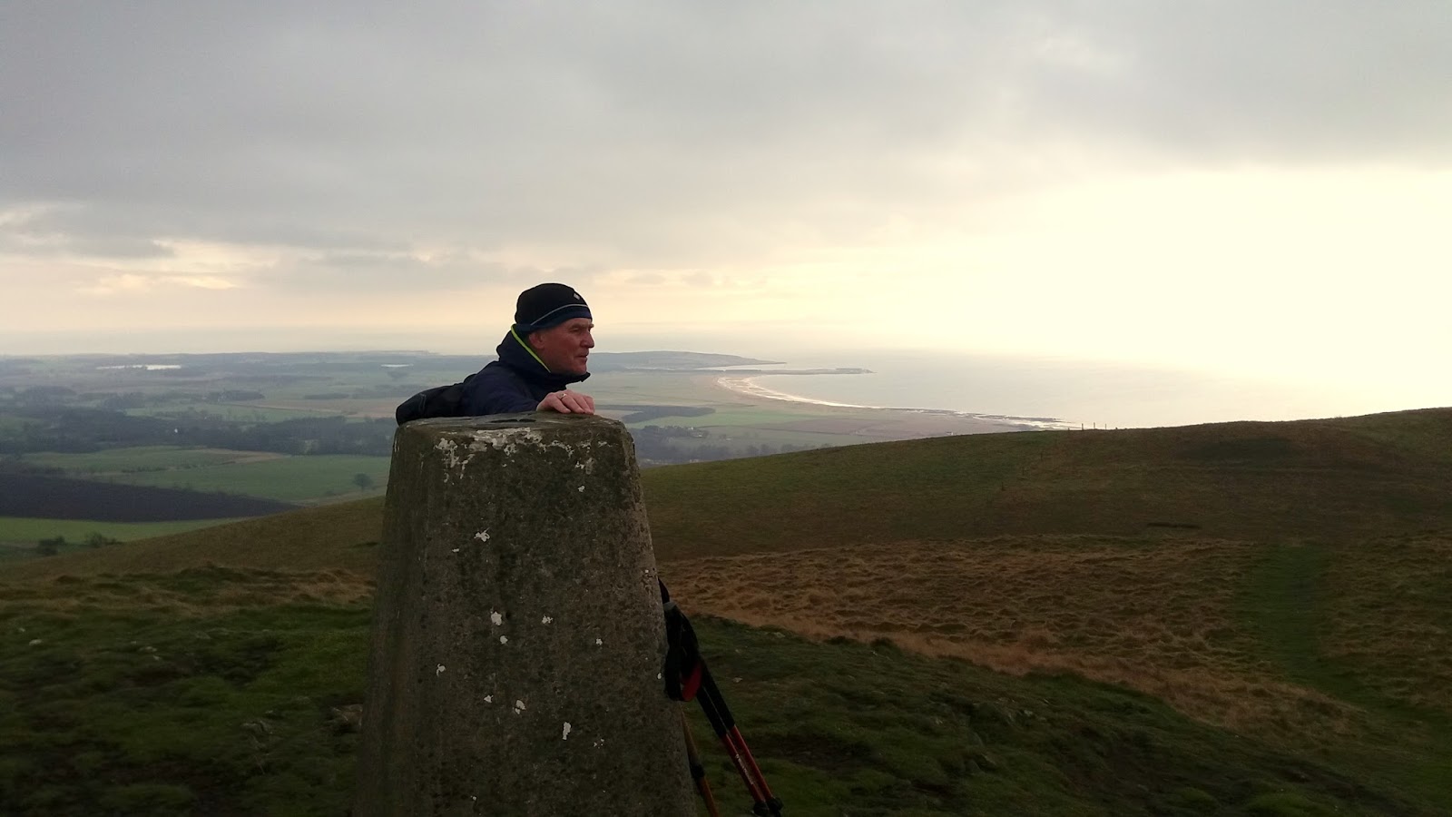
Trig looking to Bishop Hill
 The path winds it's way across the moor and goes right to the trig but go further, over the fence and stand at the edge. The views are absolutely cracking as you stand and look down on the wide expanse of Loch Leven and the surrounding flat lands farmed by the RSPB at Vane farm. Looks great from here but not good memories of fishing there. 
Scotlandwell and Bishop Hill
Behind Loch Leven lies the village of Scotlandwell and Bishop Hill which I was up earlier this year. 
Glider getting towed up
A glider is being pulled up and a huge flock of greylag geese fly over, easily a couple of hundred. The circle the loch for ages before swooping down to rest and feed.
Loch Leven
It is not a hardship to stand here and soak it in. The only downside was over to the West the other hill I was considering is still in cloud.
Across the way the landscape is clearly not natural and is the terrain of an Iron age fort. Probably better seen from above, reminder check Google Earth.
On my way down a kestrel hovers. Not sure if I have just been lucky or are they getting numbers back but I have seen a good few across Scotland over the last few months, long may it continue.
Finally all over, a grand wee walk with once again beautiful views for minimal effort. I will head over to Dumglow and see what it is like.

Wildlife: Tits-blue, coal & great; Kestrel; Carrion crow; Jackdaw flock (over 50); Greylag geese.

Time: 1.16
Ascent: 644ft 
Distance: 2.29m 

Tuesday, 23 July 2019

Great views in Ballater and the clegs are back!!

Hill: Craigendarroch
Category: Sub2k
Height: 402m
The weather gods altered our plans for a high level walk so I had to break the good news message to the good lady. I decided that we would return to Ballater and go up the short, but steep, wood and craggy Craigendarroch. Even for her.
The cunning part of my plan was that I got to cycle the 17 miles to Ballater a cracking ride through stunning countryside. Plus a return home, made.
No trains here
Our walk started at the stunningly refurbished Ballater railway station.
We had left our walk book but how could you get lost, the hill is in front of us? Not through the housing estate surely. Well the crags were not the obvious route so after asking an old guy, wrong move, we followed the field edge alongside the games park heading out of Ballater. There were yellow markers which did not seem right. Thankfully a woman appeared and we were not on the official route but could get there through the woods.
The bin marks the entry spot
There was a path but no signs so on we went. Paths began to criss cross so I just picked the one heading up that looked as the feet of humans, not deer, might have ventured this way.
We did gain height and after a few naughty words, the good lady hanging well back, we stumbled upon a red marked post, more like it.
Path at first but is it the right one
The good path climbs and winds its way up the hill through the magnificent ancient woods, initially oak trees the Scots pine and birch. It is very humid and sticky. The crags are steep and shiny, glacial wear from way back. As you look down this feels a lot higher than the actual height.
Shiny steep crags
The track is hemmed in with blueberry/bilberry plants, the purple/blue fruits perfect for eating, sweet and tasty. There are regular fresh blue/black scat marks all the way up the trail, I presume they were deposited by a pine martin marking its territory from eating all this fruit.
Memorial cairn looking down on Ballater
Finally we break out onto a flattish rocky area where the trig stands and just further away a huge memorial cairn and a marker board. The welcome wind very strong and gusty, storm on its way.
Seat marks highest point
The granite has been noticeably scarred by the ice formations millions of years ago. Good timing as we just watched the documentary last week on how Scotland was formed.

The views are excellent but sadly the aforementioned storm has covered the tops of Lochnagar but the local views don't disappoint particularly of Ballater itself.
A straightforward walk back down the same route and heading to where we should have been in the first place.
Just as we finished the walk, a painful stab in my leg just above my socks. Blood drawn, my first clegg bite of the year.
An excellent short little walk, warm down here in town so time for a Shorty’s ice cream.

Wildlife: Blue tit; Chaffinch, Song thrush; Wood pigeon; Ringlet.
Time: 1.49
Ascent: ft (m) 264m
Distance: m (km) 5.01k

Monday, 22 July 2019

Tap o' Noth a Pictish hill fort and what a view

Hill: Tap o’ Noth
Category: Sub2k
Height: 563m
When the good lady rose from her slumbers I told her that it was her lucky day, we were going to visit the remains of the second highest hill fort in Scotland. Not sure she quite processed the lucky bit so I left her to digest the information and went for a cracking bike ride to Linn’ O Dee, stunning scenery.
Beautiful early morning Strathdee
The reflection time was positive. After brekkie we set off for a gloriously scenic drive, which perked her up, apart from the two squished red squirrels on the road, one of her favourite species. Still, we arrived at the less than daunting hill, the Tap o’ Noth car park almost full, a tourist trap? To be fair it only holds about 8 cars and the motor home did for most of that.
New track at start
A nice new looking sandy track took us uphill to the deer fence where it became a grassy track that wound its way to the next fence.
Pleasant grassy section
 This grassy section a riot of colour and butterflies and moths aplenty. A new plant to me yellow monkey flower (according to said good lady) a highlight.
Unless you want a cross country circuit turn right here and head to the gate at the deer fence.
People on top of Tap

he top does not look far away, we can even see people moving about, not sure someone else agrees!!
Clearer view of the TAp
Now out onto the moorland where the track is more rocky but is still in great condition and thankfully for the good lady it continued to meander round the hill. 
Getting there
Views were excellent, the scarred track of Ben Rinnes prominent.
As we got towards the top both Lochnagar and Mount Keen came into view. 
There is an excellent information map to spend some time at before heading over the top into the bowl of the fort and then onto the trig. 
Trig with Ben Rinnes behind
Certainly not the biggest hill but in terms of location it is the biggest around. With a fantastic 360 degree perspective, no wonder it was the location for a fort.
It is fantastic to stand here and let the mind roam. Built by the Picts, the huge walls vitrified (burnt), probably deliberately by them to make the fort even stronger. Mind-boggling when you read the notice board at the car park, this is our history. 
Inside the fort looking to Aberdeen
Spotted a large very orange butterfly which on examining the snaps later turned out to be a ‘small’ tortoiseshell. If that’s small the extinct large version would be mighty impressive.
From the top the Cromarty coast and Sutherland are clear. The stand out peak on Sutherland, surely Ben Hope. If so there cannot be many places where you can see the most northerly and the most easterly Munros. Another reason why the good lady should be so lucky. She always enjoys it when she gets to the tops and soaks in the views.
Superb shot bringing the fort boundaries to life
The rain threatened and skirted us but thankfully we stayed dry.
A gentle descent back the same way to the car park with the promise of coffee and cake in Ballater.
A cracking MTB ride and a good wee walk with fabulous views, a good day to be alive.
I wonder how lucky she will be tomorrow?

Wildlife: Kestrel; Buzzard; Linnet; Meadow pipit; Meadow brown; Six spot Burnet moth; Small tortoiseshell; Ringlet.
Time: 1.47h
Ascent: 295m
Distance: 5.01k

Thursday, 28 March 2019

A short Ochil tramp to Dumyat

Hill: Dumyat
Category: Sub2k
Height: 418m
Dumyat is a popular hill in the Central belt, an outlier of the Ochils, with a dose of Scottish history thrown in. Way back it was a Pictish highpoint, particularly the old fort which has fantastic views over the Stirling area and the Wallace monument.
Dumyat centre old fort to right
Any guards would have to have been pretty robust on a day such as this. At the top of Dumyat the wind was so ferocious that not being blown over was an achievement in itself. I was glad that I had not gone higher today. Looking over the higher hills I could not spot any walkers, wise people.
In fact I was intending to walk Kings Seat on my way up for a fishing day but with the forecast opted for the lower hill of my two.
It was dry when I started the tourist trail and I wondered if this was a good idea with the number of people descending the track. Too popular for me.
Wallace monument in shower
Looking across to the Wallace monument a shower was blasting through but thankfully missing me.
I layered up and went up the hill track, too many clothes on, too warm but decision made to keep the gear on as the descent might be different, it was!
The descending walkers were mostly Asian of all ages and sexes, great to see, many were friendly but sadly some need to be educated in hillwalking. On a few occasions they covered the full track with no intention of making any room. Well my low centre of gravity and stocky shape means that a couple of times with no where else to go I stood my ground and they bounced off me rather than than their intention, sad but lesson learned.
Top in sight
Back on the walk it is a straight tourist track to the top from here. There is a more strenuous route from Blairlogie but not for me today. It does have excellent views down to the plains and the industrial belt.
Towards Grangemouth
Even in bad weather it would be difficult to lose this eroded track. it did not take that long to get to the top but the wind meant taking a snap without a shake was very difficult.
Summit looking to Fife
Whilst trying to balance I could still take in the excellent views across the Forth. The tracks to the other big Ochil hills were clear without walkers, wonder why?
Modern War Memorial
The war memorial, to the Argyll and Sutherland Highlanders, is modern and eye catching but does seem in some aspects out of place, just my view and probably not universal.
The fort hill from Dumyat
On the descent I went cross country to the old fort summit known as Castle Law. Dry on the way up but the first of two very heavy showers hit on this summit so limited time to take in the views but still a good look back to Dumyat.
Dumyat from fort hill
My descent was hood up head down. Short showers but very strong my face well stung from the hail.
A short sharp excellent walk that I will repeat but in the longer version.
Of course blue skies back at the car.

Wildlife: None, wise of them
Time: 1.32
Ascent: 890 ft
Distance: 4.29 km

Wednesday, 22 February 2017

Loudon Hill Short but Sweet

View from the carpark
The typical recent weather of strong winds and heavy rain disrupted my plans today. I originally had planned to climb the Graham, Blackcraig Hill in Glen Afton, but looking at the MET office rain forecast I would be very wet and cold without seeing any decent views.

Desperate for a short morning walk I drove out to Dalry to revisit Loudon Hill, another volcanic plug, short climb with great views. It is also a Hugh, I am ticking these off from the book even if I have been up them before. Rain was off and on during the drive but when I caught sight of it I could see the top so good enough. The last time I walked from Dalry (see previous blog) but today it was to be simply the hill.
Bridge over the River Irvine
I parked the car at the standard carpark, windy but dry. I opted to do the circular route going south around the back of the hill then ascending to the summit. I did not have my walking poles with me but they would have been a good idea. At least there is a wooden bridge crossing the head of the River Irvine. The ground from then on was pretty muddy and where it was just earth very slippy. Along with a heavy leaf covering and hidden greasy rocks this was a lot more awkward than it should have been.
Looked up at the crags which are used for introductory rock climbing but nobody around today.
Slippy slopes
Around the back of the hill the track is leaf covered and I find these are also a cover for deep gloopy mud. Boots well covered in the brown stuff. Up the slope hands were needed to stop me sliding on the muddy surface, did not expect to be scrambling today. Breaking out to the grassy summit a hail shower greets my arrival. 

At the trig it has eased but still very strong blustery winds. Still, I took 10 minutes or so to take in the views which even today are superb, except for the enormous amount of wind turbines. Even pockets of blue sky around. Looking south east it looks grim, glad I didn't head that way. Not many places that you can get views like this after less than 30 minutes effort.
Another slippy slide back down and followed the track round the other side and back to the car park. 
Is it summer, no.
Actually there are now pure blue skies above, quite summer looking, if not feeling. A couple of minutes later back to grim grey. It is a dramatic little hill and does look like a granite stopper.

I spend some time at the information board and enjoying the Spirit of Scotland sculpture. This area is packed full of history with links to Robert the Bruce and William Wallace, Covenanters etc. Read all about it. Then the rain came on again and time to go home.
Just over an hour up and down, about 350 feet climbed, short and sweet and I feel better. Storm Doris coming in tonight!!

Sunday, 5 February 2017

Largo Law


Another Hugh completed for Mrs B today. Spending some time in Fife and after a wet early morning the weather relented so we hit the nearest hill in the book which was Lower Largo.
The hardest part initially was finding the small cut off from Lower to Upper Largo to get to the start. We could see the grassy track going up the hill but the farm we passed had a sign no entry to hill, a debate with the sat nav and the cemetery car park was found.
On the face of it this should have been a similar walk to Knockdolian last week but it is different. Firstly, the walk in is the muddiest, gloopiest farm track that I have walked, real horrible stuff. I suspect the farmer does this deliberately to discourage walkers.

Secondly, the hill is a steeper climb than last week, not tough for anybody fit BUT. The big but is the broad grassy path was extremely muddy and very, very slippy. Combine the steepness with the non existent grip Mrs B found it challenging. Under normal circumstances I would not have considered walking poles for such a small hill but thankfully we took them. Each step was a case of forcing them into the ground to anchor you before stepping up. Like walking on ice.
The easier mud track
However to the hill. There is a sign warning that dogs must be on lead at this time of the year, none allowed March - November, as cattle normally on the hill. Thankfully there were none today, just some sheep. Once past the farm track mud continues until you get past the fields containing horses. Weave through some gorse bushes then there is the clear but eroded path up to the first top. Going up the second climb the erosion is not so bad.

Once this has been topped the trig is in sight. Take some time to take in the views. A short descent, cross an electrified fence at the broken stile and after another short ascent you are there. In fact all of the stiles we used were badly broken.

Once again the Hugh did not disappoint. Even in these conditions the views all around are excellent, particularly on the Forth side, the beaches of Elie and Lundin Links showing well, must be low tide to see so much sand. However, East Lomond can barely be seen, looks like it is still raining over there.

On the very slow way down Mrs B did slip, ending up with muddy gear but thankfully no injuries. Then 3 guys appeared near the bottom, Polish I think from the brief chat with one of them, no walking gear, training shoes, they were going to have some fun descending.
View towards Elie, Bass rock in background
Not a lot of wildlife around today, a kestrel hovering up the top. Something flew low and fast but too far away to identify, merlin or sparrowhawk, plus a raven doing some fab aerial acrobatics.

50 minutes up and 30 descending, 221 metres of ascent, ready for a coffee and cake somewhere but despite the mud still a good Sunday walk.

Saturday, 21 May 2016

Birnam Hill....Kings Seat

Off on my annual 3 day outdoor trip to Perthshire I decided to make a stop at Dunkeld and climb Birnam Hill. I have driven past this hill so often that it it was high time to see the view from the top. It is listed in the book 'The Hughes' Scotland's Best Wee Hills under 2000ft.

Most of the walk reviews I read start the walk at Dunkeld railway station but I decided to start my circuit at the quarry car park on the Bankfoot road, B867. There is parking for about half a dozen cars and two slots were already taken.
The skies were blue, warm down here but I could see the trees blowing about on the slopes. Still a hardy Scot, shorts on, jacket off away I went. 

There is a tourist notice board but it would be pretty hard to go wrong on this walk. Go under the railway underpass, I know it is the railway as a train passed overhead as I walked through, lots of noise. Almost immediately there is a good view of the flanks of Birnam Hill. Choice turn left to start the walk clockwise or keep following the level path to go anti clockwise. From my experience the clockwise option is an easier more scenic walk but it's your call.

I chose clockwise and a steady climb up a good path with magnificent golden orange ferns beginning to uncurl, a great natural sight.

At the signpost for the Stair bridge viewpoint take the detour as it is only a short way and if the light is in your favour there are excellent views to the south and on Rohallion Loch I could see a boat with a couple of anglers. I think that there is an option to continue on this path to another hill but I did not have my OS map so decided to not take a chance. The landscape after Stair bridge has been deforested and not overly attractive.
I retraced my steps and started climbing again and met a guy walking down but all he wanted was a quick hello and quickly past by.

The track had now opened out with good views and a pair a black headed gulls flew over me a few times. I wonder if a nest was nearby? The track zigzags up the hill. Still on a clear track I reached a slight decline and thought I saw a head move in a hollow. Intrigued I moved forward and met a Canadian lady with a very young tot and a small boy. We chatted for a minute and on upwards I went up some pronounced steps where I met her husband and older boy descending. A brief chat about the beauty of Scotland and then up a bit higher and I reach the summit which has a very big cairn which you can walk into.

Good views towards the west with Schiehallion prominent but the inevitable wind turbines spoiling the view.

It was a strong cool breeze and not great for my lunch break so I didn't linger long and followed the track downwards. Before too long I reached some slabs which had super views over Dunkeld and Birnam, the River Tay and east to Blairgowrie. An ideal spot to have my sandwich and just enjoy the view.

The descent takes you through the natural forest and is quite a steep descent with not a lot to look at. Clearly this would be a bit of a slog as it remains this way until I reach the track with the signs pointing me to the right to get back to my car.

It is now about a miles walk, still in the forest with the A9 for company for a while. It is a mile from this spot back to the car. I meet the Canadians again and apart from the single guy earlier they were the only people I saw today. The walk distance was 4.17 miles with 1096 feet of ascent. Including lunch it took me 2 and a quarter hours which was fine for me. Fine views including a good contrast between the flatter southern land towards Perth and the northern mountainous region you are now entering.
I think I have earned a big slice of carrot cake at Faskally cafe in Pitlochry.