Showing posts with label hillwalking. Show all posts

Thursday, 26 January 2017

Blaeloch Hill

It was a brilliant but cold blue sky morning and my dilemma was whether to climb Kaim hill from a different direction than my previous blog or try its neighbour Blaeloch hill. I felt that it was just too close to my last attempt at Kaim hill so opted for Blaeloch.
If you want it to be, this could be one of the easiest hills to tick off. I did not realise at the time that you can follow the windfarm hard packed route almost all the way to the summit, but, unless you are in a hurry, or not fit enough for moorland tramping, then I suggest don't.
The track ahead Brown hill on left
I parked the car at the wind farm entrance, parking for about a dozen cars as cars can go no further, and with a pretty cold icy wind blowing. Starting at this level you have far less climbing to do, one bonus. Well dressed I set off up the track. The sun was so low in the sky that it was difficult to look too far ahead. Also apologies for photo quality, not the best in today's light. I intended to follow the track round the back of Brown Hill then go off track. Going round the hill I squinted up and I could see what looked like a trig/cairn up to my right. 
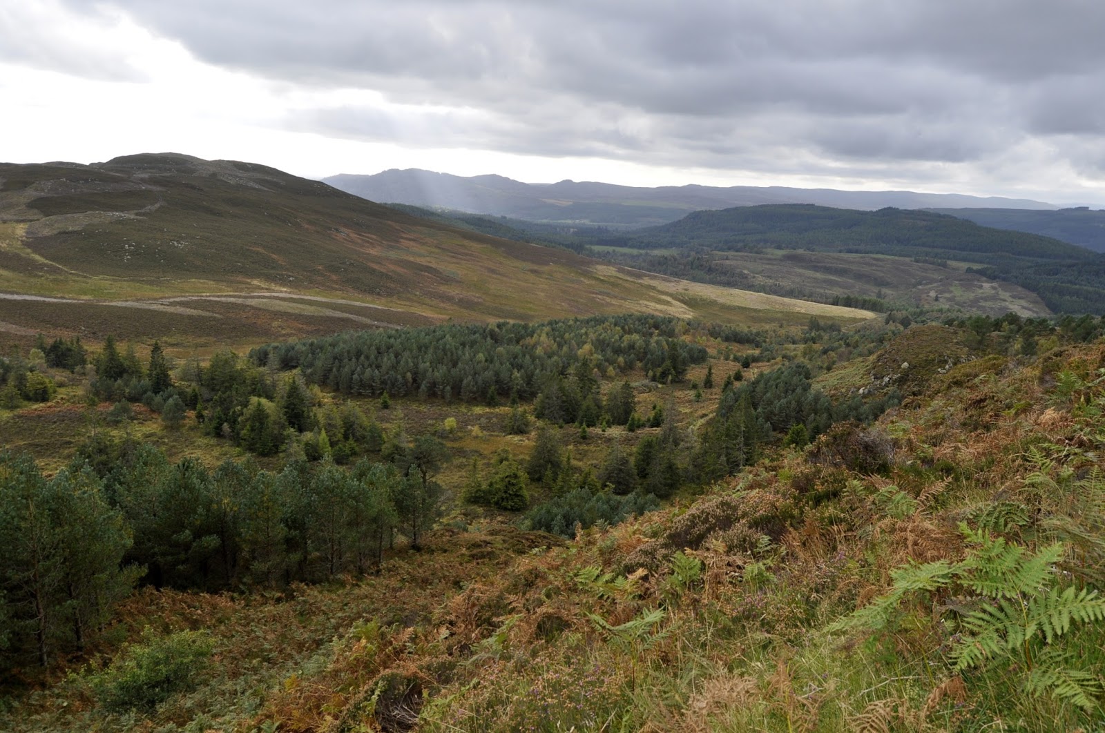
False summit and typical moorland walking terrain
It seemed a bit soon but after a mile or so I just picked a spot and left the track to aim for the cairn. Being stupid today I had not brought my walking poles so I picked my way carefully through the moorland tussocks. One advantage of a very cold night was that a lot of the boggy stuff had firmed up so walking wasn't too bad although I imagine that this could be a very different walking surface at other times. There is no tourist track so just find a sheep track and follow until it vanishes and then try and find another.
The faint track & to the true summit
I was concerned that there might be grazing hill cattle but thankfully only sheep today. I spot a shepherd's quad bike trail and follow this for a while until the the cairn comes into view and the tracks disappears. A quick pull up and I am there but as expected it is a false summit, I can see what I think is the real one in the distance. Why build a stone cairn here, it must mean something to someone I suppose.
There are good views back the way but north and west are shrouded in cloud and mist, which is a disappointment.
Now there is a thinly marked trail, more prominent than a sheep trail and for a while making the walking easier but still plenty of wet patches to get across.

Suddenly I see debris ahead and think an old tractor has been abandoned. Closer up it is clearly aeroplane debris, some significant pieces. On inspection the crater where it hit is clear to see. Time for a moment's reflection that someone obviously died here, was it bad weather, lost in cloud and mist, who knows but thought provoking.
Blaeloch cairn
Now I see the what I presume is the Blae loch, it is not very big, a lochan would be my more accurate description. Then a short clamber up to the cairned summit of Blaeloch hill. I can imagine that the views from here would be stunning out to the west in better conditions. The way the hill is angled you cannot see down to either Largs or Fairlie but you do see Cumbrae. To the south Kaim Hill stands clearly and behind me the wind farm and its turbines, the blades of all bar one rotating away, more profits for the Spaniards or whoever owns them but no cheap power for us. I sit and have my lunch with these out of sight.
Don't look this way
Also I now spot, a very short distance away, the marker post for the Fairlie walk which joins up with the Kaim hill walk in a previous blog. A hop skip and a jump and it's the wind farm road. So, as mentioned earlier, you can walk almost the whole way.

On the leisurely wander down there are good views north, including more hills in the Clyde Muirshiel regional park, one of which, Hill of Stake, is on my to-do list.
Following the track back down I reflect on how little wildlife I have seen today, a couple of ravens and a calling pheasant low down. But not one of the expected moorland birds whatsoever, not even a call, surely that can only be down to the environmental damage caused by the wind farm.

When almost at the carpark I look across to the small hills opposite and see a line of 4 buzzards holding station looking for voles etc. 3 pairs of raven can also be seen. Worth reflecting life across the road, none this side.
So a short but interesting and worthwhile day. If you want a rather more strenuous outing the hill can be climbed along with Kaim Hill but better if another car was parked at the Fairlie end. My own days climbing was only just over 700 feet but it was a good walk on a cold spring day. It's full altitude is 407 metres so I covered about half of it. Blaeloch is classed as a sub 2000 hill.
The impact crater & debris
PS: an internet search confirmed the air crash as a Fairey Firefly which took off from Ayr on a navigation exercise in Oct 1944, never to return. Both aircrew were killed.


Thursday, 19 January 2017

Kaim Hill part 1

Fairlie Moor
The incredibly unusual temperate climate for mid January is perfect for getting outdoors early in the season. After last weeks storms and snow the mild air (from the Canaries apparently)  has removed most of the snow, at least down here, so time to get a lung blowing uphill outing.
My original plan was to go to Luss and bag a couple of new Grahams, Beinn Eich & Doune Hill. But, although the forecast was to be mainly dry, it also had some showers with heavy low cloud. If I am going to put this amount of effort in I want the views so parked this for another day. My default local choice was Kaim Hill, a lower hill, but this would be a first for me, so a good alternative, plus only 30 minutes driving. A search of the internet and also some of my guide books and the route option from Fairlie station was chosen.
As forecast the clouds were a deep grey, the wind was stronger than yesterday and dry so far, so geared up off I went. 
A left turn at Fairlie station and heading along a narrow lane to soon follow the sign pointing to the right, directly past the front door of a cottage, and then follow the track, through the wood, up the side of the Fairlie burn. Birds are singing in the bare trees, so springlike. The snow melt has softened the ground so means a very muddy track but also fast running water in the burn, the noise level increased by a multitude of small waterfalls. I have to cross this burn at some point later, no bridge apparently!! After only 10 minutes it is already time to offload the mid layer thin fleece, too warm, and don the gaiters for mud protection. Glad I brought my walking poles as the ground very slippy.
A short way up a modern fence blocks the way to Fairlie castle and diverts you to the nearby path. The castle is now apparently private property and is being renovated, local access disputes ongoing.
Breaking the treeline
Continue uphill and as the trees open up a little to let in the excellent views you are met with 'the moor' sign. I always think that there is a slightly ominous feeling when coming across signs for a moor. For me the connotations of an open moor are akin to Sherlock's case, the Hound of the Baskervilles, wide open poor ground, bad weather, with few people around and lots of danger lurking. Probably very true apart from the hound.
No crossing here Lairdside hill straight ahead
The burn is still roaring noisily away on my right as I break the treeline and I now have sight of the open moorland ahead. There is a path of sorts but there is also a lot of bog, probably it is here the full year round. A stile is crossed and it is worth stopping to stand on the top, look back,  and take in the views of the Forth of Clyde, beautiful. Sadly you cannot ignore the views of Hunterston power station and the coal docks.
Ahead of me are sheep, moorland and the tops of wind pylons. Thankfully I don't go right to these pylons. A buzzard flies by as do two calling ravens. A sheeps skull on a fence reaffirms that not everything survives up here.
My guide says to cross the burn as soon as you can after leaving the trees but deep gullies indicate not yet, keep following the muddy track.

At the signpost for Kelburn wind farm or Kaim there is now an opportunity to cross the burn. Take it and continue uphill following the the line of the fence and a boundary wall. 

Cross here
The wind has strengthened and it has got noticeably colder. Looking back I can see rain showers further north and the Loch Lomond tops are now covered in cloud, so good choice made earlier not to go there.
Looking to Kaim hill from Lairdside hill
I have reached the top of Lairdside hill and its small stone cairn, this is a very remote top. I can see the trig point of Kaim hill on my right but there is no obvious track leading to it. It looks like a descent and ascent of around a mile on really crappy walking, at least so far there was a boggy track. The tops of the wind pylons to my left are being encircled and then released by the encroaching low cloud. It is a bleak landscape and I have seen no other person on the moor, not even a shepherd. I have my compass but decide not to venture further today. If I had company then I probably would have went on, but on a short daylit day, with the cloud coming down, a moor is not the place for a lone walker to get into difficulty.
Wind turbine disappearing
So back down the boggy track I go, in no rush, soaking in the Clyde coast views.
Without anticipating danger, my foot goes straight into a hidden boggy hole, entering well over ankle deep and trapped solid. If I had not been leaning on my walking poles and fallen over, a twisted or broken ankle would have been a real possibility. As it was it took an effort to release my foot from the boggy suction. It rather reinforced my decision to not take the chance. The hill will still be there for a better day. Then, it dawned on me. that I had forgotten to pack fresh socks, wet feet for the drive home, another lesson learned.
Hunterston & coal area Arran beyond
The remainder of the descent was straightforward and ended with a nice chat with the owner of one of the cottages at the station.
Back home, whilst studying Google maps etc,  I indulged in a couple of cans of Drygate's Orinoco breakfast stout, a very fine tasting beer. Next week I will tackle Kaim hill again but this time from the Fairlie moor road side. Here's hoping part 2 will be a success story.
Looking north Argyll & Holy Loch
Despite not meeting the hill objective I did meet the exercise objective and got in some good preparation for the hills on this years planner, flat walking keeps you fit but does not adequately prepare you for the hills. The distance was only 3.33 miles but included 1011 ft of ascent so it gave the lungs and heart an outing. The views were superb at times, I was outdoors, what not to like.

Sunday, 23 October 2016

Allermuir & Caerketton Pentland Hills

Allermuir Hill from Caerketton
My principal objective today was Allermuir Hill (493m) which also included 3 other tops, a fine up and down walk. I set out from the Harlaw carpark which meant firstly traversing Harbour Hill, Capelaw Hill, then Allermuir and onwards to Caerketton. I returned by the same route. There is a fair old descent and ascent between each hill so a bit of a blowout for heart and lungs.
Arthurs Seat from Caerketton
The BBC weather app showed blue skies and sunshine. As it turned out the outward leg had an autumn squall, very high winds and very cold heavy rain. Luckily it was a SSE wind so it was at my back throughout. 
Capelaw Hill not sure what this represents
There were surprisingly a few other walkers around presumably also looking to take advantage of the good weather!!
From Harlaw across the fields to Harbour Hill
By the time I turned the rain had gone off but the strong wind remained. 
As always great views all around particularly over Edinburgh & the Lothians plus across to Fife, . Never a bad walk to do so get out and enjoy it. 
Allermuir trig looking over the southerly range Scald Law etc
The walk was 8.67 miles but felt longer as there was almost 1700 feet of ascent and took me 3 and a half hours. There is a shorter walk starting from the ski centre.
New Forth Bridges in the distance

West Lothian

Thursday, 6 October 2016

Ord Ban Aviemore


99.9% of the people who visit Loch an Eilein park their cars, walk around the loch and depart. It is a loch of repute and history but to be honest I always find the walk a bit too sedate and even boring. These visitors are oblivious of the fact that there is an easy peasy hill walk right beside them with outstanding views.
The gate in the deer fence
We walked in from our cottage in Aviemore but most people will drive and pay the £2 parking fee, no avoidance there is a manned booth. On the walk in the hill is in good view but its flanks appear tree covered with no obvious view of the summit.
From the car park the hard bit is finding the way over the deer fence. The Walkhighlands site has a walk report showing a large stile over the fence. Up and down we walked, no sign. Spoke to the car park attendant who said just go through the gate behind the ruined bothy!!
The faint trail
Once through the gate turn immediately left and follow the very faint track that zigzags up through the trees and ferns. The sun was out with plenty of butterflies sunning away and lots of other beasties buzzing about.
Mrs B zigzagging
The path is faint and narrow but in reasonable condition. In one muddy pool deer hoofprints were clear but we did not see any, plenty of cover for daytime hiding. Keep looking back as great views of the Cairngorm area.
Scrambling rocks looming
Once you break the tree cover there is a minor piece of easy rock scrambling, kids would love it. Now open skies, the flattish area covered in heather and new trees and a track leading to a trig point.
Trig in sight
When reached, about 50 minutes as Mrs B with me, the 360 degree views are quite astounding. Pitlochry is clearly seen below to the north. To the East the Cairngorm massif and the sky lifts.

Looking south the rolling hills of the Dalwhinnie area are also clearly identifiable. Turn a little and looking now towards Kingussie I am sure I am looking at the Glencoe peaks but the biggest one could even be Ben Nevis. Lastly to the west is Geal Charn Mor, a Corbett in a recent blog. For such little effort quite simply outstanding views and it is a tickbox as it is a Marilyn category hill.
Aviemore below
However there were lots of big flying things annoying us so down we went retracing our steps. We were fine but friends I told this about went up about two weeks later and between the 15 of them they found 25 clegg bites!! Admittedly they did not descend by the same route, ended up going through thick bracken and ferns and had to climb the deer fence, not advised.

When we reached the bottom we treated ourselves to an ice cream in the tourist shop. We also decided to finish with the hours walk around the loch. As said before minimal birdlife in the trees and next no birds on the water. If you want a bland forest walk then go for it.
Loch an Eilein
Facts: 10.4 mile walk with 857 ft of ascent and a 5 hour day out. Official height of Ord Ban 428 metres.
A walk back to Aviemore and a couple of pints of real ale sitting outside the superb Old Bridge Inn completed a fine day.

PS:Scotland are playing Malta tonight, surely not a downer to the day!


Deuchary Hill Dunkeld


My expectations were that this was going to be a straightforward smallish hill with attitude and good views. It was, but it turned out to be a lot more adventurous than my expectations, all my fault of course.
I am using the 'The Hughs' book as this years walking guide and too be fair I have discovered some hills and landscapes that I would have passed by.

From my holiday spot in Pitlochry I drove the short distance to the starting point at the Cally carpark Dunkeld. However, I was to follow the A923 which had a road closed sign just by Dunkeld, diversions in progress and two cars three point turning as I arrived at the turn. Not knowing how far up this road the carpark was I was either brave or foolish, but went through the closed signs and found the car park only about 100 metres ahead, good.
A very bumpy quarter of a mile drive, got parked, only car in situ, got gear together and wandered down to signposts which as you can see there are a few paths around here.

Onwards up the Mill Dam track I went, in good fettle, taking in the changing Autumn colours of the countryside. The guide told me that at Glack kennels go through a metal gate. I reached a big metal gate, sign Glack kennels alongside attached to the fence, so through I went. Yes you have guessed. After a mile and more of steady climbing on a newly laid forest track I was doubting myself. 
Wrong track

It just did not seem right. I had not brought an OS map as I thought it would be straightforward and the book had a small map, big mistake. Luckily the phone had a 4g signal in the middle of a forest, surprising as it doesn't have one in Pitlochry!! Google maps confirmed I was in the wrong place although a faint track might have joined up. Not taking the risk as this was a newly laid forest track so back I went.
At the junction, guess what, a yellow marker sign pointing to the right, twat.
Onwards I went hearing dogs barking in the distance, the kennels? The track is good and I went by Upper Hatton and entered an open area. On my left sheep were being ushered in to a field higher up than I. Watching the sheep I then heard my arch nemesis, coos, bellowing behind me. Looking back a herd of black cows with young were moving at pace down the path I was on. Where had they come from? I walked faster heading towards the building I assumed was the kennels. Safety was reached without a coo attack and guess what a big metal gate!!
Track up the side of Mill Dam
Shortly after I reached Mill Dam and then as guided followed the track turning immediately right following the upper path to Loch Ordie. Fully laden Rowan trees all the way up.
Turn Right
You get some water views of the loch, but no fisherman or boats, and a pleasant, sometimes boggy, path up to a ruined bridge where you then take the immediate right fork.

Again the path has some boggy sections as it climbs gently upwards. I have a hill in my view which I mistakenly think is the objective, not for the last time on this walk. On the slopes I spot a deer in the ferns apparently undisturbed by the shooting on our right, grouse shooting I presume with double shots each time.
Easy to miss turn left
This path is actually a route heading for Loch Ordie, Deuchary hill seems to be a by product as you could easily walk by the almost hidden exit from the track taking you up the hill. It seems just a break in the undergrowth, no sign.
Now, there is a faint trail to follow and a short but pretty steep section, my heart was pounding, lost fitness. The track breaks out into a picturesque clearing and I look to my right at the climb ahead. Wrong again as I soon spot that the track actually goes towards the hill on my left. As I plod upwards, head down, sweat dripping, my peripheral vision catches some deer disappearing over a top, I presume I had disturbed them.
Loch Ordie below
The wind was now pretty strong and cold so outer layer jacket on. I reached the summit and the trig, although it was a grey cloudy day the views are still worth it, albeit not as far and wide as expected. Loch Ordie shows well along with a large white country estate mansion, rich people live down there.
Fallow deer stags
I move the short distance from the trig to the sharks fin of rock which is the true summit when I get my reward for my effort. Two stags are sitting just below the summit, sheltering from the wind. One of them had an unusual coat with a line down its centre and I was unsure about the shape of their antlers. Later research informed me that they are Fallow deer which was a first for me. I watched them for 5 minutes or so before the cold wind decided I was off the top but this is what the effort was worth.
Lochan na Beinne and River Tummel towards Pitlochry
On the way down I spooked a partridge which decided to run down the path in front of me, constantly stopping and looking back, turn into the ferns I thought. On the hill to my left two figures with dogs appeared on the horizon, obviously part of the shooting party, grouse season I presume.
View towards Dunkeld on descent
Back at the kennels I decided to take the cowards approach and avoid the field of cows so followed an alternative track, parallel I thought, towards the Loch of Craiglush. As the trail continued to head in the opposite direction from my destination I got a sense of deja vu from the start of the walk. This time 4g indicated a dead end path. Dilemna I set myself a target of walking a further 1.5 miles and if I had not reached a sign/water/road I would turn back and face the coos. Almost to the mark I saw water and descended to the loch and then walked the road back to the carpark.
There was meant to be a forest trail back to the carpark from the Loch of the Lowes but I did not see it.
Two diversions meant a round trip of 11.97 miles instead of the expected 7-8. Time was 4 hours 44 min. An ascent 1889 ft but all in all a good trek and another 'Hugh' achieved.
Lonely car park
Definitely time for a beer.