Hill: Knock of Braemoray
Type: Sub2k
Height: 456m
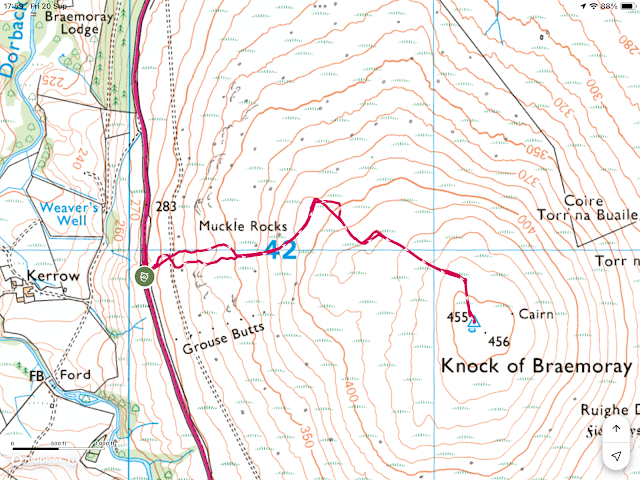
With a potentially poor weather forecast I was looking for a quick up and down and this was the closest one to my base. Not surprisingly for a wee hill like this there was only a few reports on Walkhighlands, starting from various points, so I chose a route that described a clear track through the lower heather slopes.
Lovely scenery and good weather as I drove to the start. The road goes round the hill but I had already noticed a few clear path options but not near my start.
I parked up at my start at a lay by alongside a mast, easy to find. So far so good but that was about to change.
In front of me was a thin wall of native trees with no obvious track through to the heather slopes. Walked up and down but where to start? With Sub2k’s getting access to the hill is frequently the hardest bit.
I had a good phone signal so checked the Walkhighlands app and this was indeed the spot for the route I was to follow.
So I picked a spot and had a short battle with a steep slope and low hanging branches before I got to the fence. Wow knackered and big doubts about this already after just 5 minutes.
 |
| No sign of a track |
 |
| Still no sign of a track |
Over the fence and immediately into deep heather and tussocks with no sign of a track. I took short sections of 10 or so careful steps, head rotating madly, looking for this track, but no joy. There have been quite a few times that I questioned the validity of some of the so called ‘our routes’ on Walkhighlands, particularly for Sub2k’s. I presume they are guesswork after the event rather than accurate GPS, possibly memory fade?
 |
| Not what I was looking for but it will do |
It was a bit wet and overgrown, not been used for a long time but much better than the heather.
 |
| Turbine track preparation? |
Further up the track became wider semi flattened tracks, quite obvious to me that this was early preparation for a yet another wind turbine site.
 |
| At least the views were opening up |
But being a hypocrite I used these tracks, easier than the heather/tussocks off piste.
Before long the trig was spotted but no track to it, rubbish terrain what a finish to the ascent.
The good lady had asked me this morning what I thought the views would be like. My response was that despite its lowly height, it was a stand alone hill, so weather permitting could be good.
As it turned out the views were a lot better than good. The cold northerly wind had cleared any haze so although they were not high look down views, the long distance 360 degree vista was superb.
 |
| Ben Rinnes |
As I approached the trig the obvious pointed peak behind it was the Corbett Ben Rinnes.
 |
| Cairngorms |
The views across the Cairngorms went as far as to take in the torr's of Ben Avon near Braemar. Also the Aviemore northern Munro slopes had a significant white coating of snow that was going to freeze tonight, what a sad year, unreal.
 |
| North and the Ben Wyvis plateau |
North the views were great over the Moray Firth and Ben Wyvis but extended as far as the Torridon hills many miles away.
Descent was simply a retrace with great care being taken over the heather and tussocks. Even with the higher viewing perspective no track was obvious. Stumbled a couple of times and at the finish I realised my water bottle had fallen out of the rucksack and there it will remain.
Overall objective achieved with a short ramble and the bad weather did not arrive. Worth a short ramble for the excellent views but pick an alternative ascent route.
Ascent: 185m
Distance: 3.2km
Time: 1.24
Wildlife: Meadow Pipit; Red Grouse


