Showing posts with label Fort William. Show all posts

Monday, 4 August 2025

A fine day for an outstanding hill.....Beinn Resipol

Hill: Beinn Resipol (Homestead)

Type: Corbett

Height: 845m


This was my 4th attempt to bag this cracking hill which has been on my to-do list almost since I started hillwalking. On the other occasions my free day had been wet and/or cloudy but I was holding out for a clear weather day as I knew that the views would be spectacular and today was one such a day. The SMC book describes the view from the top as ‘ one of the finest views along the West Highland coastline’ so not too be missed.

There are two options for the ascent and I chose the one from Resipol caravan site which is arguably tougher, longer with a greater ascent as starting from sea level. But, you do have the conical view of the hill whereas from the eastern approach the summit is of the flatter ridge and not quite so scenic.

I had been warned that the walk from here could be a bog fest but I was confidant that after these weeks of no rain the going would be ok.

Lovely view down Loch Sunart at the start

I was aware that the caravan park had changed hands and was not sure about parking but good for them they have left space for about 5/6 cars for hill walkers.

It was a very quick boot change as the midgies were in full biting mode, wow, should I get my head net out?


Headed off through the beautiful oak woods full of birdsong and thankfully no midgies. A short open section before hitting a mixed natural wood, there was good shade for a while. I was struggling to get a good walking/breathing rhythm as the track steepened.

The boggy (dry) section

Out on the hillside I now had a view of the hill which it looked quite steep from here. This middle grassy section was the bog fest and although it had dried up considerably there were still many unavoidable boots in mud sections but a lot better than it might have been.

Then onto rougher ground following the right hand side of the Allt Mhic Chiarain where it enters a nice narrow gully. The track is very narrow at times and is easily lost particularly as the ascent steepens sharply and slight hands on sections add to the interest.

Looking ahead I could not see any obvious route but the as I gain height the track does begin to head towards the bealach on the left of the summit. It looked very craggy but I was sure a route would be there.

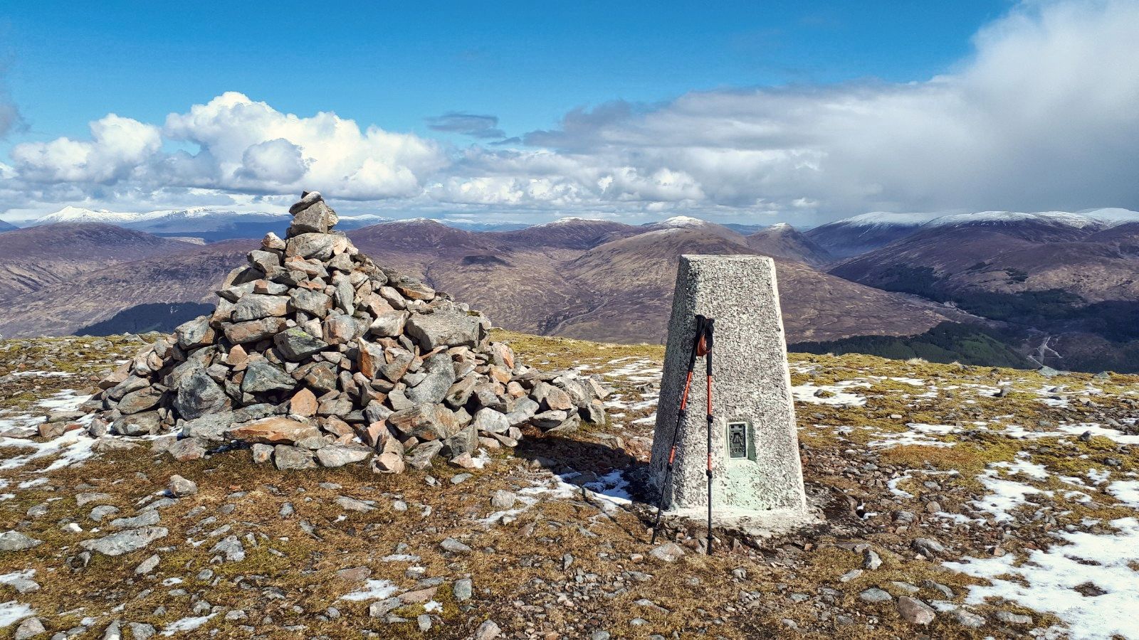
Large cairn is up there

A slight plateau is reached and you could head up at any spot as there were a few narrow grassy sections between the boulders.

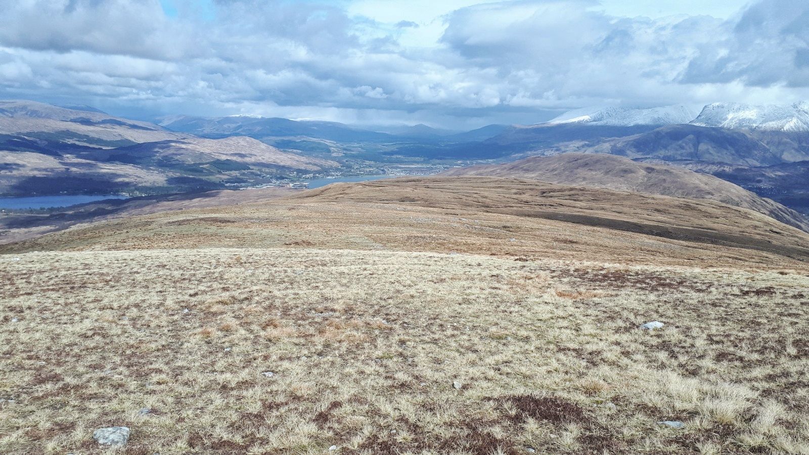
Views east Ardgour Corbetts forefront Mamores behind

Loch Sunart

But I continued on the rising plateau until it almost drops away before making my meandering route upwards through the boulders to the top.

Loch Sunart to left Loch Shiel on the right

A short easy scramble leads to the top and its huge cairn. Then a wee scramble up the stones to the wooden pole marking the summit.

Loch Shiel back to Glenfinnan

The SMC description did not mislead. The views, despite the slight haze, did not disappoint. Quite stunning a widespread as the snaps show.

Back down via the lochan

Sadly up top the midgies had returned now supported by clegs, I killed two of them before deciding to down by the same route.

Eigg on left, Rum behind

Back at the car I was delighted to find that there was a breeze and it was midge free, yippee.

Today was a top ramble to a fine peak and I was so glad that I had waited for that blue sky day. Also worked up a good appetite for the taster menu at The Kilcamb Hotel which was only a few hours away.


Ascent: 868m

Distance: 12.9km

Time: 4.56

Wildlife: Mistle Thrush; Greenshank; Meadow Pipit; Grey Wagtail; Cuckoo (h); Woodpecker (h); Willow Warbler;

Saturday, 13 May 2023

Surprisingly good little ramble.....Beinn na Gucaig

Hill: Beinn na Gucaig (Mountain of the little bell...bluebells?)

Type: Fiona

Height: 616m


On my way heading further north I decided to take a break and tick this Fiona off. The last time I went to do this I was on my way back from another trip. Sat in the car park with the rain bouncing deafeningly off the roof, Why, I asked myself, for once sense prevailed and home I went knowing the hill will still be there.

This morning I left home in a drizzle with cloud touching the rooftops, crap visibility so another abandonment was a possibility. But as I neared Tyndrum things started to brighten, I could see the sides of hills and was much better by the time I got to the start.

I was a bit grumpy as I skipped brekkie at home to eat at the Green Welly. A coachload of Americans arrived just before me so the queue was massive despite nobody at tables. They were all buying takeaway coffees/teas and all paying individually. The two couples in front of me all paid with a £20 note, the guy on the till was equally not a happy chappy. Still, the roll was good.

I parked in the forestry Commission car park at Inchree, more popular with dog walkers than Gucaig baggers I suspect.

I followed the red trail from the car park (paths are marked for woodland walks) and turned right onto a motorway sized hard packed road.

Almost missed the start to the ATV track that takes me up the hill, it was only marked with a ragged piece of pink tape. I expected a really boggy track but overall it was pretty good.


Mast on top of  this hill

It is a winding grassy track that goes up and up. Toil relieved by a Cuckoo calling, my 2nd of the week, moor nesting birds look out.

I had a 5g signal up here was it this?

A few false tops before I spotted a mast which I had forgotten about, hence the ATV track. Part of it was spinning around rapido. I had not really done my homework so thought I was near the top as I felt I had climbed quite a bit and the water looked a long way down. Although I had covered about 2/3rds of the ascent the hill was still quite a way away. 

Gucaig from Pt575, i went right to ascend but came back more direct descent on the left

Up the next small hill, still not it, so onto the next one which had a small cairn, point 575 on the map. Surely this was it I mumbled to myself as I eyed up the descent down to a moor and what looked like a steep climb to a higher top and looked far away. Time to check properly and of course I knew that that was the top of Gucaig over there.

So down the dryish slopes onto to boggy pathless ground. Followed the odd deer trail before climbing again and yahoo a trig came into sight. As I touched it I heard voices, I had not noticed anyone ahead of me. Two English guys having lunch I think a bit peeved I had spoiled their tranquillity, tough.

Inverscaddle Bay

View down loch Lhinnie
The views were pretty good considering the clouds were covering all the Munro tops but this one had stayed under them so far.

View back to point 575

Views across to Blether Munros
The best views were reserved for looking down to the water and especially down over Corran and down the ever widening Loch Lhinnie. Had it been less hazy Mull would have been seen but not today.


Tanker going thru the Corran straights but no ferries today

Cruise ship heading for Fort William

I took a different way off the top but mainly returned the same way taking in the fabulous scenery. A track for the most part made this a straightforward ramble but if doing it leave it for a good viewing day, it would just be a slog otherwise.

Ascent: 611m

Distance: 10.2km

Time: 3.11

Wildlife: Cuckoo(m) calling; Meadow Pipit; Skylark; Great Tit; Red Grouse

Tuesday, 11 May 2021

Definately a white mountain today and another fine Corrie.....Beinn Bhan (Great Glen)

Hill: Beinn Bhan (Great Glen) (White Mountain)

Type: Corbett

Height: 796m

My legs were stiff and achy, there is no doubt that Covid jab took its toll. But overnight there was doubts about my planned walk on Saturday due to an incoming storm apparently! A different type of storm  from the snowstorms we are experiencing. So decided to get a walk in today just in case.

The forecast was similar to yesterday, lots of showers snow and hail on the higher tops. Out for my pre brekkie walk I noted that the local hills had received a fresh dusting overnight. Looking for somewhere local I decided to do the walk covered by Gordon & Liz earlier in the week. But rather than be a copy cat I decided to walk this anti clockwise. Looking at the map the gradient looked easier, selfishly thinking about my poor body.

A short drive to the beautiful Glen Loy and the walk start at Inverskilavulin. Construction work at the bridge but the workies okayed my parking in the turning area. This already looked a steep climb from here.

Shooting & fishing sign
I had to laugh at the sign on the riverside, warnings to kayakers. Today there was barely a trickle of water but clearly it can get full and hairy.

Start with initial climb up the middle gorge and trees
I took the track around the estate buildings and holiday homes ( not cheap a self catering studio from £325 a night!!) and started following the various on-off tracks through the dead bracken which in a few weeks will be a different beast. Then reached the stream and followed it up. 

Lots of lovely small waterfalls cascading well, presumably snow melt. I saw a grisly scene quite high up a dead sheep obviously the carcass being eaten by scavengers, another reason not to drink from a burn low down. I was just reading this morning about two kids drinking water from a burn, got e-coli and both had serious kidney damage.

Crossed the burn here
I was already painfully slow and struggling as I crossed the burn heading for the old broken fence line. 

From the fence it was a case of very slowly plodding up the grassy moor terrain. I have never had so much leg/backside muscle ache on a walk ever. And I don't think I have taken so many short pauses, again ever. This really was a case of mind over matter, I could easily have turned back but was determined not too, I had plenty of daylight.

Coire Mhuillinn
Thankfully I had on off views of the top ridge and good views into Coire Mhuillinn, excellent excuses for many a breather.

I had a small rock formation as my target. I knew this was far from the top but it would be the beginning of the end of the steep gradient. Light snow showers on and off so hood stayed up.

Finally reached the rocks and I knew from the map, now confirmed with eyesight, that the gradient eased which was gratefully received. Motivation improved. 

Trig just visible middle of photo glad the snow shower passed through 
A lot rockier underfoot along with a covering of soft snow and then the trig was spotted. It looked too far away!!

Excellent views from summit
Obviously it wasn't that far and in 5 minutes I was at the summit in 2.05. I would have sworn it was another hour onto that with all these stops, very surprised indeed.


Panorama looking North
But the effort was well worth it. The views of snow topped hills was long and far and the vista was the full 360 degrees. The snow showers scudding through all round made everything atmospheric. 

Meall na Teanga snow topped beside Loch Lochy
Snow underfoot, snow topped clouds, blue skies, dark grey clouds and a rusty landscape, not bad at all. 

Loch Arkaig
I loved the views down to Loch Arkaig, memories flooding back.

Perfect horseshoe ridge
Now the fine long ridge walk to get me back. It is a proper high level horseshoe with old fenceposts as a guide if required. 
About to get a snow shower

The only down side was the heaviest snow of the day walked the ridge with me only ending as I descended. At least it was side on then at my back.

The descent grassy slopes (taken on my ascent) with the Graham Stob a Ghrianain behind

The long grassy rocky descent was a scabby one, quite horrible walking. The only satisfaction was that I had not ascended this route. With the way I was feeling a seemingly never ending climb with my nose stuck into the grass I would probably have turned back, my motivation would not have matched the effort required.

Before long the estate houses came into view, I took my time, no ankle twists  wanted with freedom to travel out there.

Back at the car in under 4 hours absolutely delighted with that. It took a lot of effort today but so glad I continued as those views will remain in memory. Another walk with lots of deer prints and droppings but still no sight of the mysterious reds.

Back to the car to find walk cancelled for tomorrow. Time to rest this body anyway until I feel normal.

Ascent: 776m

Distance: 9.1km

Time: 3.49

Wildlife: Cuckoo (m & f calling); Woodpecker (knocking); Wheatear; Meadow Pipit; Robin; House Martin; Blackbird; Blue Tit

Saturday, 8 May 2021

A long moorland grind but a fine Corrie and 50 up.....Stob Coire a'Chearcaill

Hill: Stob Coire a'Chearcaill (Peak of the circular corrie)

Type: Corbett

Height: 771m

We now have our Covid freedom but recently life for me has been one of changing plans. I couldn't do my planned itinerary but decided to complete the Fort William section. Covid freedom wouldn't be the same without Covid vaccinations. I had my second one earlier in the week and it had a much more debilitating effect than the first.

So with weaker legs, dodgy breathing and wondering about my fitness I set out on my journey. Not just Covid the bloody weather has gone nuts with heavy snow forecast in many places. As I drove through Lomond, Orchy, Glencoe plenty of white stuff on the hills but as I pulled into the Coran ferry the Morvern hills were clear, I could see the back of my target, the highest in Ardgour, with minimal snow and some blue patches up there. Along with my first ferry journey of the year I was excited.

Got to the start point at Blaich and the expected 'no parking notices' were in place but pulled into a grass strip opposite, nae problem. One of those days what to wear? It was certainly going to be cold up top, strong chance of snow showers so I went for winter gear.

Good trail
I knew it would be a plod of a hill and the initial section is an estate track that goes all the way to the top moor. Down here my winter gear was a mistake as I was sweating going through the sheltered tree section. I was not feeling brilliant due to the jag and if it had been snowing hard I probably would have said no way! But it wasn't so headgear off, zips down, jacket vents opened. I ascended the trail to the accompaniment of a calling cuckoo, was it calling for a mate or laughing at me, 'cuckoo', quite probably.

Reach the cairn and get my first view of the ridge
Moor reached and the first objective is a large cairn which is reached by pathless walking across the moor, some awkward walking but under these relatively dry circumstances it was fine. It is just a slog for me today but at least the all round views are superb, on the ascent, mainly the Glenfinnan hills. Carefully watching tops engulfed in a heavy grey cloud which disappeared leaving a fresh coat of white stuff. And wondering when one was going to engulf me.

Attractive sweeping ridge
After the cairn another long stretch but this time your view is focussed on the crags surrounding Coire a'Chearcaill looking good.

The terrain becomes more rocky and slightly tougher walking but a fine ridge leads you to the top. 

Trig and the large cairn, a good windbreak
Suddenly and a bit unexpectedly the trig is seen then soon reached and the large cairn was welcome shelter from that wind. For the last 200+ metres the wind has been raw but at least I was still dry. 2hours 10m, I will take that with these dodgy legs. 

Morven hills left side heading to Glenfinnan range surprisingly snow free

Looking over to Glencoe hills
From here the superb views focus on Morven hills, still without snow and the Mamore's & Glencoe ranges with plenty of the stuff.

Just a superb view
It was interesting during the moor walk watching the number of herring gulls that were soaring over the tops, pairs and larger groups, rising from Loch Linnie and descending down to Loch Eil. Must have been over a hundred over the course of the walk. Mating time or just having fun surfing the wind?

In poor conditions the corrie could come into play
Nourished but with one eye on the weather fronts I headed back down, examining the views into the corrie, deep and isolated. Red deer must be in there. I had seen plenty of signs of them but no live beasts. However back to the corrie, in full winter conditions or bad weather and with a cornice one would need to take care up here.

Yip that's the long moorland trek back down
The descent was a repeat of the plod up but this time the views are dominated by Big Ben and the surrounding hills, Dearg & the Aonach's. Plenty of snow and I am sure a few tourist walkers might be regretting their choice to ascend it today.

Aonach (left), Dearg (centre) and Big Ben
Still plenty of snow showers over Glenfinnan hills and over the Ben but other than a few spots hitting me still dry.

Steam power
A plod back to the car without incident. But the unmistakeable sound of the Jacobite had me looking and then spotted across the waters of Loch Eil, a great sight and sound. An enjoyable walk for the views of the corrie and the 360 degree vista of hills but not so much for the plod. 

Tight, tired legs and a beer deserved for number 50, sadly will be canned or bottled. But at least I can choose whether to walk a local hill tomorrow or relax before Saturdays commitment. 

Looking back at the hill from Loch Eil it is definitely a featureless nothing but as always it depends how and where you look at something that angle not its best.

Ascent: 828m

Distance: 14.7km

Time: 4.11

Wildlife: Cuckoo (heard); Meadow Pipit; Blue Tit; Grey Heron; Buzzard: Curlew; Red Grouse