Showing posts with label Lochaber. Show all posts

Monday, 4 August 2025

A fine day for an outstanding hill.....Beinn Resipol

Hill: Beinn Resipol (Homestead)

Type: Corbett

Height: 845m


This was my 4th attempt to bag this cracking hill which has been on my to-do list almost since I started hillwalking. On the other occasions my free day had been wet and/or cloudy but I was holding out for a clear weather day as I knew that the views would be spectacular and today was one such a day. The SMC book describes the view from the top as ‘ one of the finest views along the West Highland coastline’ so not too be missed.

There are two options for the ascent and I chose the one from Resipol caravan site which is arguably tougher, longer with a greater ascent as starting from sea level. But, you do have the conical view of the hill whereas from the eastern approach the summit is of the flatter ridge and not quite so scenic.

I had been warned that the walk from here could be a bog fest but I was confidant that after these weeks of no rain the going would be ok.

Lovely view down Loch Sunart at the start

I was aware that the caravan park had changed hands and was not sure about parking but good for them they have left space for about 5/6 cars for hill walkers.

It was a very quick boot change as the midgies were in full biting mode, wow, should I get my head net out?


Headed off through the beautiful oak woods full of birdsong and thankfully no midgies. A short open section before hitting a mixed natural wood, there was good shade for a while. I was struggling to get a good walking/breathing rhythm as the track steepened.

The boggy (dry) section

Out on the hillside I now had a view of the hill which it looked quite steep from here. This middle grassy section was the bog fest and although it had dried up considerably there were still many unavoidable boots in mud sections but a lot better than it might have been.

Then onto rougher ground following the right hand side of the Allt Mhic Chiarain where it enters a nice narrow gully. The track is very narrow at times and is easily lost particularly as the ascent steepens sharply and slight hands on sections add to the interest.

Looking ahead I could not see any obvious route but the as I gain height the track does begin to head towards the bealach on the left of the summit. It looked very craggy but I was sure a route would be there.

Large cairn is up there

A slight plateau is reached and you could head up at any spot as there were a few narrow grassy sections between the boulders.

Views east Ardgour Corbetts forefront Mamores behind

Loch Sunart

But I continued on the rising plateau until it almost drops away before making my meandering route upwards through the boulders to the top.

Loch Sunart to left Loch Shiel on the right

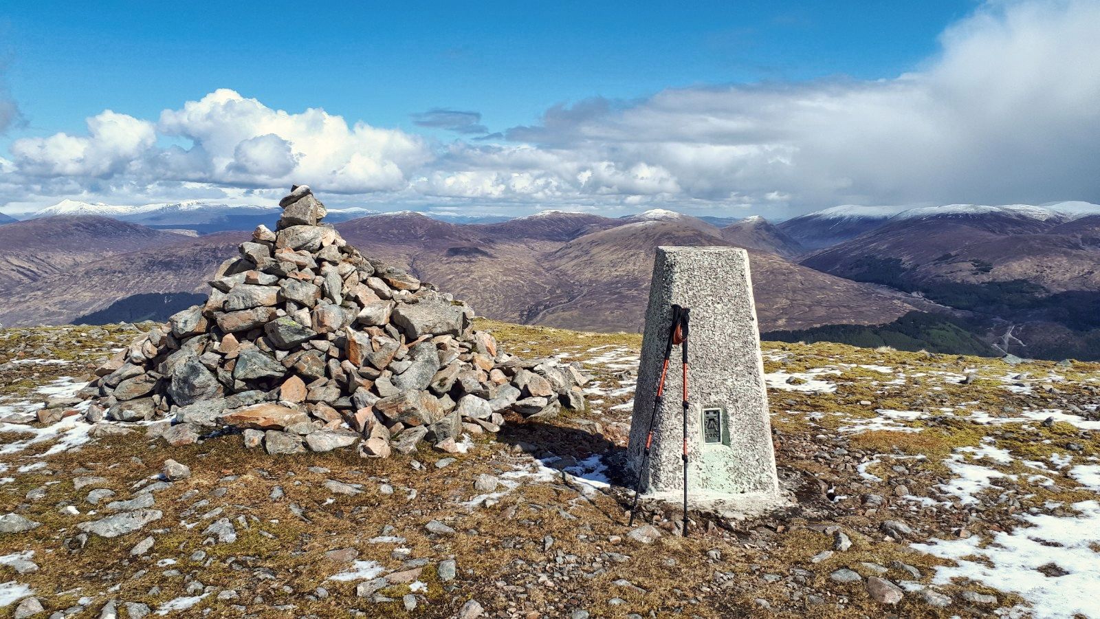
A short easy scramble leads to the top and its huge cairn. Then a wee scramble up the stones to the wooden pole marking the summit.

Loch Shiel back to Glenfinnan

The SMC description did not mislead. The views, despite the slight haze, did not disappoint. Quite stunning a widespread as the snaps show.

Back down via the lochan

Sadly up top the midgies had returned now supported by clegs, I killed two of them before deciding to down by the same route.

Eigg on left, Rum behind

Back at the car I was delighted to find that there was a breeze and it was midge free, yippee.

Today was a top ramble to a fine peak and I was so glad that I had waited for that blue sky day. Also worked up a good appetite for the taster menu at The Kilcamb Hotel which was only a few hours away.


Ascent: 868m

Distance: 12.9km

Time: 4.56

Wildlife: Mistle Thrush; Greenshank; Meadow Pipit; Grey Wagtail; Cuckoo (h); Woodpecker (h); Willow Warbler;

Tuesday, 11 May 2021

Definately a white mountain today and another fine Corrie.....Beinn Bhan (Great Glen)

Hill: Beinn Bhan (Great Glen) (White Mountain)

Type: Corbett

Height: 796m

My legs were stiff and achy, there is no doubt that Covid jab took its toll. But overnight there was doubts about my planned walk on Saturday due to an incoming storm apparently! A different type of storm  from the snowstorms we are experiencing. So decided to get a walk in today just in case.

The forecast was similar to yesterday, lots of showers snow and hail on the higher tops. Out for my pre brekkie walk I noted that the local hills had received a fresh dusting overnight. Looking for somewhere local I decided to do the walk covered by Gordon & Liz earlier in the week. But rather than be a copy cat I decided to walk this anti clockwise. Looking at the map the gradient looked easier, selfishly thinking about my poor body.

A short drive to the beautiful Glen Loy and the walk start at Inverskilavulin. Construction work at the bridge but the workies okayed my parking in the turning area. This already looked a steep climb from here.

Shooting & fishing sign
I had to laugh at the sign on the riverside, warnings to kayakers. Today there was barely a trickle of water but clearly it can get full and hairy.

Start with initial climb up the middle gorge and trees
I took the track around the estate buildings and holiday homes ( not cheap a self catering studio from £325 a night!!) and started following the various on-off tracks through the dead bracken which in a few weeks will be a different beast. Then reached the stream and followed it up. 

Lots of lovely small waterfalls cascading well, presumably snow melt. I saw a grisly scene quite high up a dead sheep obviously the carcass being eaten by scavengers, another reason not to drink from a burn low down. I was just reading this morning about two kids drinking water from a burn, got e-coli and both had serious kidney damage.

Crossed the burn here
I was already painfully slow and struggling as I crossed the burn heading for the old broken fence line. 

From the fence it was a case of very slowly plodding up the grassy moor terrain. I have never had so much leg/backside muscle ache on a walk ever. And I don't think I have taken so many short pauses, again ever. This really was a case of mind over matter, I could easily have turned back but was determined not too, I had plenty of daylight.

Coire Mhuillinn
Thankfully I had on off views of the top ridge and good views into Coire Mhuillinn, excellent excuses for many a breather.

I had a small rock formation as my target. I knew this was far from the top but it would be the beginning of the end of the steep gradient. Light snow showers on and off so hood stayed up.

Finally reached the rocks and I knew from the map, now confirmed with eyesight, that the gradient eased which was gratefully received. Motivation improved. 

Trig just visible middle of photo glad the snow shower passed through 
A lot rockier underfoot along with a covering of soft snow and then the trig was spotted. It looked too far away!!

Excellent views from summit
Obviously it wasn't that far and in 5 minutes I was at the summit in 2.05. I would have sworn it was another hour onto that with all these stops, very surprised indeed.


Panorama looking North
But the effort was well worth it. The views of snow topped hills was long and far and the vista was the full 360 degrees. The snow showers scudding through all round made everything atmospheric. 

Meall na Teanga snow topped beside Loch Lochy
Snow underfoot, snow topped clouds, blue skies, dark grey clouds and a rusty landscape, not bad at all. 

Loch Arkaig
I loved the views down to Loch Arkaig, memories flooding back.

Perfect horseshoe ridge
Now the fine long ridge walk to get me back. It is a proper high level horseshoe with old fenceposts as a guide if required. 
About to get a snow shower

The only down side was the heaviest snow of the day walked the ridge with me only ending as I descended. At least it was side on then at my back.

The descent grassy slopes (taken on my ascent) with the Graham Stob a Ghrianain behind

The long grassy rocky descent was a scabby one, quite horrible walking. The only satisfaction was that I had not ascended this route. With the way I was feeling a seemingly never ending climb with my nose stuck into the grass I would probably have turned back, my motivation would not have matched the effort required.

Before long the estate houses came into view, I took my time, no ankle twists  wanted with freedom to travel out there.

Back at the car in under 4 hours absolutely delighted with that. It took a lot of effort today but so glad I continued as those views will remain in memory. Another walk with lots of deer prints and droppings but still no sight of the mysterious reds.

Back to the car to find walk cancelled for tomorrow. Time to rest this body anyway until I feel normal.

Ascent: 776m

Distance: 9.1km

Time: 3.49

Wildlife: Cuckoo (m & f calling); Woodpecker (knocking); Wheatear; Meadow Pipit; Robin; House Martin; Blackbird; Blue Tit

Sunday, 23 June 2019

A fantastic high level Glencoe ramble

Hill: Bidean nam Bian (Peak of the mountains) circuit including Stob Coire Sgreamhach (Peak of the horrible Corrie)
Category: Munro
Height: n/a
Route up between The Sisters heading for Stob Coire nan Lochan (middle)
It was with great anticipation that I started today’s walk into this impressive and somewhat daunting landscape. How many times have I parked in the Glencoe car park and looked at this scene and said ‘must do it‘?  Storar says that the big Buachaille is the scenic icon but Bidean is the supreme hillwalkers mountain.
Well today was the day. No Japanese tour buses taking photos of me departing!!
Follow the burn
Our small group left in sunshine and followed the excellent trail up into Coire nan Lochan, following the burn, heading for the great buttresses ahead. The feeling of immersion as the great cliffs narrow in. The burns crystal clear waters utilised to replenish the water supplies further up. Not always recommended doing this but done me no harm so far. Plenty of small waterfalls to admire.
Aonach Eagach ridge
Looking back fantastic views of the Aonach Eagach ridge, lower down I made out a solitary figure heading along, one day maybe.
First obstacle about half way up was a smooth rock descent, easy enough but the first of many hands on scrambles today, some more challenging than others.
Falls
As we reached the lochan under the buttresses a waterfall was in full flow, as was the weather. The sun lotions were forgotten as the rain arrived. Wet gear donned including gloves for me as it had turned decidedly nippy.
The good NTS track has now disappeared. We took a right (west) and after heading up some grassy slopes found the marker cairn.
Example of the rocky scramble
Now we were well into the cloud (we entered it circa 900m) we had a prolonged period of pathless rocky scrambling.
We came over from the left
At one point we were only about 10 yards left of where we should be and a huge drop appeared. Wow that was close. A short detour and we could view the drop, albeit in cloud, a timely reminder. On the other side a brief and welcome glimpse of Glencoe below.
We continued the circular rock scramble to arrive right at Stob Coire nan Lochan (Storar says it is the finest of Bideans peaks, need to take his word for that). After all that effort it should qualify as a Munro. From the reading I had done beforehand the extent of the prolonged rocky scrambling was a surprise to me.
Still not too far to the first one proper. The cloud protected us from the views of the ascent ahead, despite scrambling a looming mass could be seen up there through the greyness. Glad we circled around and up the last bit to reach the summit of Bidean nam Bian.
Cloud starting to lift
This is the highest point in Argyll and just as we reached the cairn, the clouds were occasionally parting to give us fleeting glimpses of the superb views. As we lunched it started to lift properly and we could enjoy the views we had worked hard to get. The ridge ahead now clear so we can see the route towards Stob Coire Sgreamhach .
Looking down to The Lost Valley
It was a leisurely stroll along the ridge taking in the views of the big drops down into Coire Gabhail and The Lost Valley beyond. Also out towards Etive, plenty of big hills.
Back to Bidean
Looking back we have a clear view to Bidean, quite superb. Quite a few walkers around, few came our route.
Stob Coire Sgreamhach ahead
Although the climb up to our second Munro looked quite steep from here we accomplished it in good time. 
Light and darkness Loch Etive
More views to enjoy but the clouds are lowering again, a clear high front over Etive and low pressure just above.
Now the dreaded descent off the bealach. The chute is fully eroded at the top section so no option other than to take the steps to the right before rejoining the chute. It was one to go very, very slowly, full concentration on each step. Lots of loose rocks and still very steep. Thankfully better stepping stones are reached and a path evolves.
Scree slopes descent to The Lost Valley
Whilst taking time to regroup the midges decide to assault us, no Donald Trump Iran reprieves here, and they were biting. The smell of insect repellent now strong in the air.
When we arrived at the flat area known as the 'Lost Valley' the tourist walkers from the car park were out in numbers. The valley was used to hide rustled cattle by the Macdonald's of Glencoe but god only knows how they got them up here in the first place. The section up from the River Coe and up the burn is a steep and rocky section in its own right.
A short stream crossing takes us into more bouldery terrain, easy to lose the path here. More short scrambling, found it again, and down the path to the final wet rocky section where a wire hand hold has been erected, helpful it was too.
Glad to be back at the car park, it had been a long walk out.
Stunning day with good company which helped the walk go by. One of the bucket list.

Wildlife: Raven, Meadow pipit.
Time: 7.55
Ascent: ft (m) 1422m
Distance: m (km) 13.8km

Sunday, 2 June 2019

This time a very grey day back in the Grey Corries

Hill: Stob Ban Grey Corries
Category: Munro
Height: 981m

Despite the weather forecast being grim we opted to head back to the Grey Corries for this Munro.
Gloomy start
The slight downside with this hill is the very long walk in (and back), which, as we had some slower walkers, meant almost two hours to the bothy.
Cruach Innes on the left saw a couple heading up its flanks as we passed
To be fair it did not feel like that long as it is a pleasant walk along a hard packed trail. Sadly the low lying clouds took away much of the potential view sbut the Corbetts on our left looked imposing in this light. The glen terrain looked perfect for cuckoo’s but never heard or seen them. Too wet and cold so probably done the business and headed back to Africa! Left the upbringing to the pipits we saw.
Welcome bothy
The rain was getting heavier as we arrived at the bothy, time for a quick snack. The bothy is in excellent condition.
Looks calm but the burn was flowing fast
The outgoing burn crossing was better for some than others with the higher water line but the rocks helped. The ‘bridge’ further up is broken, angled and not worth thinking about.
We turned off at the small cairn and followed the track under the crags and climbed following the burn, there is one particularly bad step where the track is eroded (ie non existent) but for the main part this was a very wet and very boggy ascent/descent.
The only brief glimpse we got of Stob Ban
For a short while the track disappeared and we went back to low visibility navigation but thankfully found it again. A ptarmigan appeared out of the gloom and soon after we sprung a pair of red grouse.
Stob Ban from the ridge the other day
The rain got heavier, the visibility got poorer but we followed the zig zag stony trail to the top. 
Thankfully I had looked down on it a few days ago in good weather so I knew the views and landscape but felt sorry for the others.
Brief glimpse of the top of Sgurr Innse on the descent
Wind and rain stronger so back down the same route for a while. We bypassed where we lost the route earlier and took a different and steeper track on the descent. Lots of angled wet rock and muddy eroded sides so not easy. I reckon this track  leads to the ruined bridge and was the original track. However, near the bottom of the descent we cut over and rejoined the original track.
Burn and path cross at the bothy
The rain had slightly altered the burn crossing. It had widened and was running faster but not too much deeper so we all got across with varying degrees of wet feet.
Thankfully back at the bothy once more for shelter and food.
Then the final four mile walk back to the cars in the rain.
Two field hares decided to join us for a trip down the rutted path. A nice end to a good walk despite the weather.

Wildlife: Meadow Pipit, Ptarmigan, Red Grouse, Field Hares
Time: 7.07
Ascent: 977m
Distance: 21.3km

Friday, 31 May 2019

Scaling the Aonach's the cheats way

Hill: Aonach Mor (1221m) & Aonach Beag (1234)
Category: Munro

Today was jestingly called our rest day as we were only doing two Munros with over 800m of climbing. And sad to say we did them with assistance, not all shoe leather effort. The gondola ride took us a long way up the hill (650m). It was a pleasant and relaxed way to go up a hill, except when it stopped a few times swaying in the breeze, along with excellent views. These hills are in the top ten of the highest Munros. 
Steep start
Still, despite the initial aid this was not straightforward. The uphill climb from the gondola station, up the steep grassy slopes was rather gruelling. No doubt yesterdays big efforts were still in the legs so a bit laboured.
Relief to get onto the ridge and we could now see the route ahead but our labours were not over.
Fort William
The views over Lochaber and district already outstanding. Along Loch Eil the eye finds Rum & from a later angle Eigg. Angle around Little & Ben Wyvis in the distance.

This is a broad plateau with warning/danger signs, easy to walk off the edge in bad weather. But no danger today in this clear visibility. Superb views as you would expect.
Aonach Mor plateau and cairn ahead 
Just under 2 hours from the start we reached the cairn of Aonach Mor. On one side fantastic clear views over yesterdays Grey Corries ridge circuit. On the other the CMD and Ben Nevis clear of cloud. Views all the way out to Rum.
Beag top in distance from Mor
On our way to Aonach Beag, which from here looks much higher than where we are standing, but is in fact only higher by 13 metres. Funny how distance and panorama plays tricks with your perspective. Our forebearers named these hills after their bulk not their height.
Aonach Beag
A gentle descent and the grass was over. Now it is a rocky scree path to half scramble, half walk up. There are various routes, just pick the one for you and before long the second top has been reached.
View to the Grey Corries
Another wide flat top and time to take in the superb close ups views of the westerly Mamores, Glencoe hills and much more.
CMD ridge behind
Quite a few walkers spotted going up the Ben via the CMD arĂȘte, would love to do that one day.
Ben Nevis & CMD in foreground 
There were weather fronts bypassing by so lucky us. Ben Nevis summit was now in cloud, bad news for the late starters.
Return back up the bulk of Mor
A return by the same route with the steep grassy descent, easy on the feet but challenging the knees, a bit painful.
Back at the gondola station and time for well deserved coffee and cake. 
The MTB World cup is taking place this weekend so great views from the gondola of the course being laid out. The forecast does not look great for them, sad.
Another great day in great company and Scotland at its best.

Wildlife: zilch
Time: 4.51
Ascent: 886m (2906ft)
Distance: 10.4km (6.25m)