Showing posts with label Strathyre. Show all posts

Monday, 24 February 2020

Great to be out, a wee winter jaunt up Beinn an t-Sidhein

Hill: Beinn an-t Sidhean
Category: Sub2K
Height: 570m

Walkhighlands describes the walk: ‘Beinn an t- Sidhein rises high to the west of Strathyre and offers fine all round views;.
It was a relief to get a walking window of a day to get out in our great outdoors. The last few weeks have been driving me stir crazy.
The forecast was for all the seasons in one day. A mixture of snow showers and sunshine. The opportunity to get views was a plus. The wind on top was forecast to try and knock us off our feet, we would have snowy conditions from fairly low down. And a major snow storm was due later on today.
Suitably energized a few from Killie ramblers set off in anticipation.
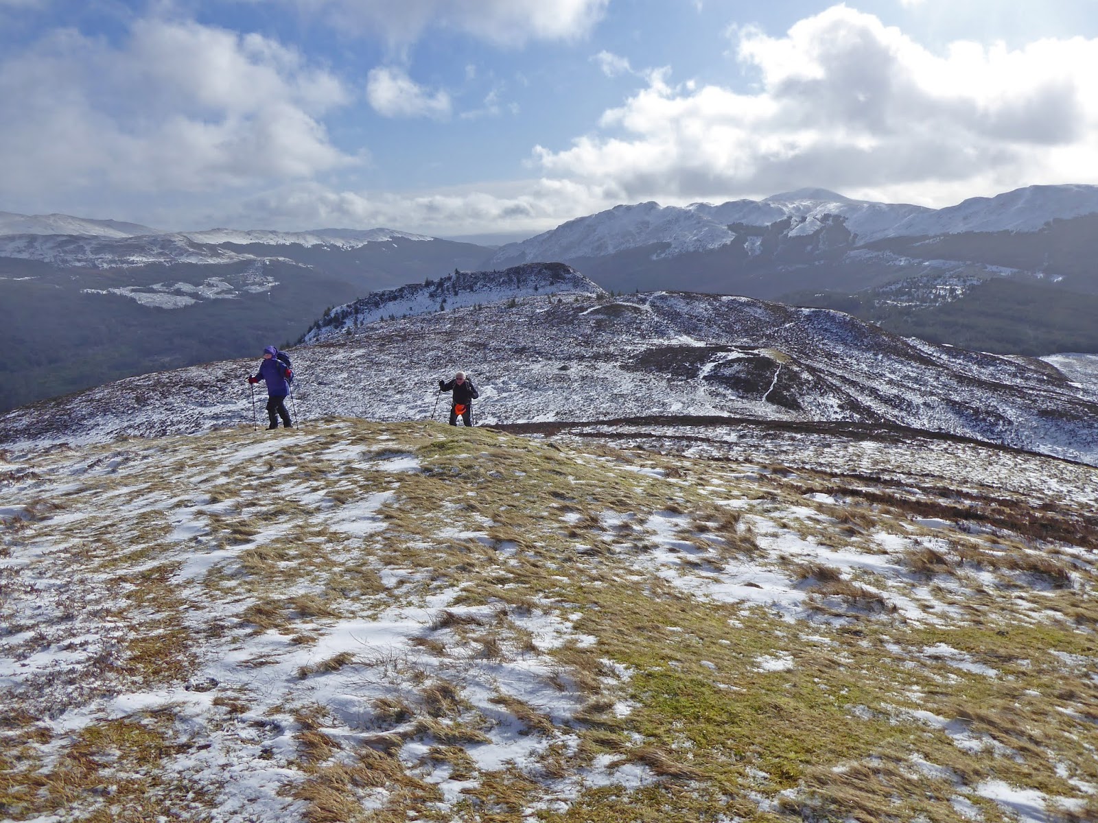
Marked path to 1st viewpoint
We started at the Forestry Commission car park at the southern end of Strathyre, beyond the Broch cafe. The walk description goes left to the suspension bridge but we went right to cross the arched road bridge and quickly soon found the hill start.
Heading up there
After a few weeks of gym work the hill legs were not quite there so the very steep start up to the viewpoint was tougher than it should have been. Spotted a roe deer in the trees, a good start.
The viewpoint was excellent but the low sun meant low grade pictures over Loch Lubnaig. However, looking down on Strathyre reinforced the height gained in a short time.
Beautiful patterns on the rocks
No more path signs after this so we followed deer tracks up the snow covered hill.
Follow the deer tracks
We had now lost the path in the snow but headed upwards  following a small burn. Deeper pockets of snow made it more interesting.
We were aiming to the left of the prominent mound of An Sidhean, the temptation is to head straight up it but we resisted and found the faint track.
Next viewpoint looking over to Vorlich etc
This track winds up to An Sidhean but at this point the winds decided to reinforce the accuracy of the forecast. The gusts were trying to knock us over. The views from the small cairn were excellent particularly looking across to Beinn Each, Vorlich and Stuc a’Chroin.
Our route and that stile

Looking back to the viewpoint and Ben Venue
But it was obvious this was just a viewpoint and the summit was a few ups and downs away. A larger cairn here than the true top. It would be a fine place for a snack on a good day but not for us in this wind.
Back down the snow and ice path then followed the snow track to the fence and a small stile. Small maybe but this wind it made something easy a challenge.

The snow now hid some significant boggy patches, plenty of mud on the boots. Just hoped we would not be going in too deeply. The wind had decided to ramp up even further and staying on our feet was a challenge but it was fun and the views terrific.
Someone has rolled in the snow!!
The summit is marked by a few rocks thrown together but the real view was about 20 metres further on. Not just the hills but looking down on Lochearnhead, was special.
Looking across to Vorlich, Stuc a'Chroin and Beinn Each
Overall a superb 360 degree viewing hill top. Sadly we could not hang about too long in the wind and headed back down our ascent route.
Plateau top looking north
Snow and hailstone storms came and went but these did not spoil the day. Indeed when they blew through and the views opened up again, more enjoyment.
On the descent Loch Lubnaig and a couple of walkers heading up
A great little winter walk. The weather forecast spot on. Good company for a chat and views to remember. It was good to be back.

Wildlife: Roe Deer; Buzzard; Raven; Black Grouse; Wren;
Time: 3.31
Ascent: 674m
Distance: 6.6km

Friday, 1 November 2019

A forestry walk up to cheese hill

Hill: Sgiath a’ Chaise (wing shaped hill of the cheese)
Category: Graham
Height: 645m
On my way back from a trip I stopped off at Strathyre my base for tonight and decided to stretch the legs before tomorrows walk. It was now noon and into the short winter days period. I had considered this hill as a joint outing with Ben Each but I was wary of finishing before darkness tonight so opted for this effort taking the easy forest route from Strathyre.
I plotted a quick route through the forest trails on my OS map app but I could see from down here that sections had been deforested. I reviewed Google earth whose last images were dated 2017 and only showed a few obvious tracks. I altered my route based on this and for once made a smart move as a lot of the tracks on OS no longer exist because of the forestry operations.
I knew I would be making a large S shaped walking route through the trees, not exciting but exercise.
Rob Roy Way Cheese hill in view
Surprisingly the blue sky had disappeared en route and it was now very low cloud which at times was dusting the tops with snow as they passed over at a snails pace.
The walk began at Strathyre by initially following the Rob Roy trail through the woods until I met one of the forestry tracks.
Turned right and started my S route but avoid taking any cut offs. To be fair most of these turns had red no entry ahead signs and before long so did mine. Ten seconds of thinking time, ignored it and I plodded on.
Evasive action required
The good gradient made for easy walking but before long I could hear the noises of timber operations. Shortly after turning back on the long middle section I came across a truck loading trees so being adventurous I ducked off the path into the forest, gloopy and muddy, before back onto the track after bypassing the lorry. Cannot turn me back if they didn’t see me.
Summit up behind the mast
From here the scenery opened up as I was on the long middle section of the S. I reached the 1st mast and followed the route round to complete the S as it headed upwards to the 2nd mast. The top in sight.
Gate to climb
Just before this mast I spotted a gate in the deer fence, locked of course, so a climb over an onto the moor and then headed up to the ridge where I met a dilapidated iron fence line. I followed this to the high point, marked by a single iron post, typical Graham top.
Ben Each & Glen Ample
Looking across the top of Ben Each is hidden in cloud but far below Glen Ample looks attractive. I can see the track heading to Loch Earn It looks quite a steep pull from down there to get up here glad I did not combine both, there will be enough like that tomorrow.
Far away is that The Cobbler from an unusual angle?
Anyway still good views and what is that sharp point far away to the west, The Cobbler I think.
Beinn an-t Sidhein in foreground Stob a' Choin snow topped
Up here it is a very cold wind so back to the fence to shelter for a snack. Lots of deer poo around but no creatures up here.
I climbed the large fence but on the descent one section gave way and then the next one down, so a quick jump off, reminder need to lose weight.
I simply followed the route back, no obvious descent through the deforestation and I did not want to risk injury on my own.
Tomorrow's hill under cloud
Stumbled across two roe deer who bolt straight into the trees. Bright white bums shine in the gloom. I wonder why such excellently camouflaged animals have such conspicuous rear ends?
Strathyre with Ben Vane behind in low cloud
Excellent views looking down on Strathyre village and the surrounding hills, autumn colours and white tops.
Again met the working vehicle, lights blazing, who luckily for me moved just as I arrived saving another off route mud bath.
Back at Strathyre safely just as the light is fading. Not one I will be back on but exercise and fresh air on a crisp day. Time to check in and rest, tomorrow will be a lot more strenuous .

Wildlife: Roe deer, jay (pair), blue tit, red grouse, flock of fieldfare.
Time: 3.37
Ascent: 598m
Distance: 16.1km