Showing posts with label Sandra. Show all posts

Sunday, 30 October 2022

A hot day on Arran.....Cir Mhor

 Hill: Cir Mhor (The great comb)

Type: Corbett

Height: 798m

Another day to get excited about. It was to be my 1st trip to Arran since Covid, almost 3 years has passed, unbelievable. But maybe I wasn't as excited when my alarm went off as I was going for the first ferry. But I sure was by the time I was on board and had my traditional CalMac breakfast roll.

The objective today was Cir Mhor, known as the Matterhorn of Arran, no arguments from me.

We were going through Glen Rosa but there are no buses to the String Road that tie up with this ferry. The other bus driver said she would stop as close as she could but she forgot about us, thankfully not much of an overshoot so a short walk back.

It was a hot morning even this early.


Anticipation builds as the hills are spotted ahead as we enter Glen Rosa. The walk through Glen Rosa was different. The foliage was long and so overgrown the path could not be seen at times. Lots of ski style shuffling feeling for obstacles. But the worse was the insect life. Lots of minor bites and a couple of cleg ones. One of them was 3 bites through my shirt on my back right at my rucksack. At first I thought it was just a twisted strap but nope, real bites.

So it was relief to reach the junction and start the climb proper.


That's a proper pointed peak of a mountain

Cir Mhor was looking magnificent, a grey fortress with a stunning peak against a clear blue sky what a sight.

When we reached the corrie a cooling breeze was very welcome, I had been feeling it in that heat.

Looking over to Loch Tanna, Beinn bharrain & Meall nan Damh

Up the short zig zag track and the north and west of Arran is your magnificent vista.

Lost the correct track going through the boulders and thought we had found it but it was heading for An Caisteal. So a direct line up through the grass and boulders and came across the track.


It is an interesting climb and the latter section requires hands on minor scrambling before the top is reached.

The ridge to 3 Beinns

Glen Sannox and Witches Step on left

Goatfell Glen rosa side

At the top is a small area for about 4 people to sit and take in the view. The views are amazing looking over to the Witches Step. Glen Sannox far below with the blue waters of the Firth beyond. Goatfell of course dominates and looking down Glen Rosa both the Holy Isle and Ailsa Craig can be seen in the haze.

Glen Rosa with Ho;y Isle in background

One final look back at a stunning mountain

We followed the same route back. Grateful that the breeze was now lower which made the walk through Glen Rosa much more pleasant. It is still a long haul but the beasties were hiding.

Common Darter

Dark Green Fritillary
One of the frustrations is the non buses to meet the extra summer sailings a disgrace for a tourist island. So the long walk back to Brodick and we missed the ferry by 10 minutes. Time to hang about and take in the scenery.

A cracking walk on a beautiful day.


Ascent: 878m

Distance: 20.5

Time: 7.01

Wildlife: Common Darter; Meadow Pipit; Scotch Argus; Dark Green Fritillary;

Friday, 24 June 2022

Surprisingly snowy up top.....Beinn Stacath

Hill: Beinn Stacath

Type: Corbett

Height: 771m

The forecast was good for a ramble but the recent snow made the choice a little easier, opting for a grassy slope that did not have a long peat bog crossing.

As we drove towards the hill we were surprised at just how much snow was on Ben Ledi this could prove more interesting.

Snowy top peaking straight ahead
Managed to squeeze into the small parking area and off we went along the boggy right of way to Brig o'Turk. It would certainly be more straightforward to use the estate track on the other side but out of bounds.

Fully in sight
It does not take too long before the lower slopes are in view but still a few kilometres to go before we reach it.

We crossed the river and headed for the whaleback
Finally time to cross the river which was straightforward but on the other side at the farm buildings were a herd of cattle with calves. Some of the calves were pretty lively so a detour away from them towards the base of the climb.

Now all that remained was a long slow climb up the grassy slopes with many, many false promises. Still the gradient was kind. The views around us were improving as we climbed along with a significant drop in temperature thanks to a strong north wind. Although the weather was fine it was not the expected blue sky and sunshine.

Snow line in sight

Superb light
We reached the snow line but compared to Ben Ledi this was patchy soft snow. Slippy to walk on at times but not an issue. 

Summit ridge finally spotted

Still very cold up here
After we crossed the small patch of peat hags it was surprising to see the summit still quite a bit away. Although we were in no hurry it would be around 30 minutes more than I predicted to summit.

More ups and downs and then the flat top was reached beside the rotting iron fence posts.

To be fair this top has pretty stunning views, far better than I expected. The Inverlochlarig tops dominated by Ben More. All the way down the ridge to Ben Lomond. Lawers Hills and all the nearby Trossachs stuff. On a day like this with snow topping most of them pretty dammed special.


Where's the Coos?
We descended on a more direct route but nearing the river we noticed the coos had moved to  now be in our way. So another version via the cow poo covered buildings. We had been spotted but they did not come our way. Using the humps to hide us we got back to our river crossing and then an uneventful trek back to the car.

Final stretch dominated by Beinn an t-Sidhein
A very pleasant relaxed ramble in fine surroundings, what's not to like.

Ascent: 705m

Distance: 13.5km

Time: 5.39

Wildlife: Meadow Pipit; Skylark; Raven; Common Lizard; Red Squirell,

Sunday, 16 May 2021

My last two Galloway Donalds, thank god the Dungeon Range no more.....Craignaw & Dungeon Hill

Hill: Craignaw (Craggy hill of the rock) (645m) & Dungeon Hill (Hill above the dungeon lochs) (620m)

Type: Graham & Donald

My priority this year is to achieve a Donald hill category completion. I had been avoiding this pair for some time but numbers were reducing and they had to be done. Gordon messaged me recently about doing them before the bracken and midgies overtook us, a wise suggestion. So I agreed as I did not want to leave them to be the last hills. My final comments will endorse why!!  You only need to read a few walk reports to get the picture. This is often pathless and rough going and even when it is a path it is often in poor condition. As per my blog reports I am fully familiar with notorious tough Galloway terrain so I was mentally prepared but even so it was tough walking!  

The green colour at the start is pleasant but did not last for long

All cars arrived promptly so we made early start with optimism as the good weather was forecast until mid afternoon. We set off from the Bruces Stone car park. A small group of mainly focused Donald baggers. Shortly a cuckoo was heard calling, plenty of them have arrived now, Spring is here.

Ascending the Gairland burn green disappearing

Height is gained quickly as we ascended on a slanting angle via the Gairland burn track. A few weeks ago this was apparently bone dry but not today, back to its boggiest best and we haven't had that much rain. I have read this area described as savage scenery, constantly changing. 

As we rise the burn narrows and flows faster

No doubt that today the landscape has that rugged beauty along with with the spectacular addition of the burn, flowing noisily as it cascades down some falls. We are hemmed in with the flanks of Buchan Hill on our left and White Brae top across the burn.

Loch Valley with Craignaw slopes mid right

Time for a food break at Loch Valley where I observe the trout rising frequently. Apparently a sluice was installed some years back to improve the fishing in these upland lochs, long since destroyed and this was the only water where I saw fish rising so no idea whether it has been successful or not. I might not rush back to walk these two hills again but I will be tempted to come back for some wild fishing. 

A short wander up to the next Loch Neldricken, where we cross the burn via some large boulders, nobody fell in and then headed directly to Snibe Hill. The terrain is littered with huge boulders, erratics to give them their Sunday name. When the glacial ice melted these were left in situ wherever they dropped, certainly adds to the wild scenery.

Heading to Snibe Hill huge boulders/erratics dotted around

Nice to be dry underfoot but only because we are onto the famous Galloway tussocks with only the occasional granite slabs to provide some relief. 

Snibe Hill looking south

Snibe Hill is not a categorised summit and can be by passed but it is worth the short effort as the views are really good.

Dow Loch on right and the one section of good walking to Craignaw summit


Down to the almost dry Dow Loch with the short ascent of Craignaw ahead. Dow Loch was made from the frequent torrential rain running off the granite slabs onto a granite bowl, maybe climate change has dried the area. 

Craignaw has been described as a compact but complicated hill. I can see that in poor visibility the crags could be a lot more complicated and dangerous than today but most of the danger of these hills lie on their east flanks not touched by us. Thankfully the granite slabs come to our aid and makes short work of the ascent. Craignaw summit reached but its small cairn has disappeared, its boulders strewn around, possibly a weather victim.

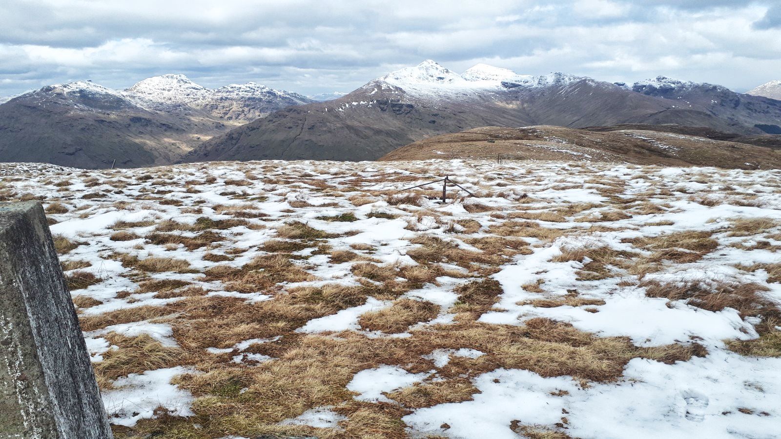
From Craignaw summit, Loch Enoch left, Mulwharchar centre and Dungeon hill mid right

It has been a tough walk but that was the end of any help from granite slabs. A steep descent down a narrow grassy passage known as the Wolf Slock with the impressive granite rock slabs on our right. 

Our approach to Dungeon Hill

We contoured west avoiding having to descend fully before starting the ascent of Dungeon hill. Followed tracks and paths which disappeared as quickly as they appeared, sheep and deer not human. A bit of huffing and puffing and before long 2nd summit achieved. Time for nourishment and take in the fabulous views. To the south the hills of the Lakes and Ireland can be clearly seen, still not summer air!

The Range of the Awful Hand

Mullwharchar and the Merrick including the full Awful Hand range (Merrick, Kirriereoch, Tarfessock & Shalloch on Minnoch). 

Silver Flowe bog bottom left and our Craignaw descent route in middle of hill

Lastly views back to Craignaw and down into the peat bog, ditch network, ground of the Silver Flowe. A similar bog existed nearby on the banks of Cooran Lane but has since fully dried up.  Behind that the Rhinns of Kells ridge and down to the blue waters of Loch Doon. A tough walk rewarded with superb views.

Down below lies the butterfly shaped Loch Enoch, the size of which is remarkable as no burn feeds it. It is very deep at least 39m, formed in a rock basin in glacial times.

The descent heading for Locn Neldricken

For the descent we flanked Craignairney heading directly for Loch Neldricken. There was a path of sorts but many a time the foot would go straight down a mud hole or worse, plenty of traps to catch even the wary.

The fine sands of Loch Neldricken

Finally we reached the loch with patches of its fine sand, famed for its sharpness in knife grinding, a very pleasant spot even if some litter left behind. Sadly came across a dead large yellow duckling. There were a pair of Canada Geese on the water with at least three youngsters I wonder if this was one of theirs?

We took the eastern side where there was another faint track back to where we crossed the loch outlet earlier. Sadly missing the famous literary 'Murder Hole' on its west bank.

Descending via Gairland Burn

Now we were descending via the out track but it was still full attention required as very awkward walking, wet, slippery boulders, lots of traps. A female wild swimmer was at the side of Loch Valley but she did not acknowledge us, odd. Then we were given an air display by an RAF training aircraft swooping up and down, spectacularly, very fast and very loud, no suppressors on these engines.

Relieved to see Loch Trool

The descent had been a long slog over very similar scabby terrain. At least on the ascent there is the excitement of the adventure ahead, differing terrain, ascent & descent etc. But this bit not to be repeated.

An indicator of how poor the terrain was is the time taken, I would expect to complete a walk in 3-3.5kph but this one was only 2.63kph.

Still that's the Galloway hills finished for me in bagging terms, any visits purely for pleasure from now on. Good company helped the time go by and the weather played its part, pleasant blue skies and a high temperature considering last weeks snow.

I have earned that cold beer or two.

Ascent: 841m

Distance: 17.2km

Time: 6,54m

Wildlife: Raven; Meadow Pipit; Canada Geese; Chiffchaff; Cuckoo( heard)

Sunday, 18 April 2021

Freedom at last.....Curlywee a fitting walk om a grand day

Hill: Curlywee (Hill of the Eagle)

Type: Donald

Height: 674m

Scotland's day of freedom when our second lockdown was eased to allow travel out with our local authority areas. An hours drive into the heart of Dumfries & Galloway seemed appropriate to bag a new Donald hill. An added bonus, Curlywee is rated as one of the finest hills in the Southern Uplands.

The Merrick start but we went right
A beautiful blue sky morning deserved an early start and apart from one idiot who decided to corner on my side of the road, I thought I was in serious trouble, the drive was a joy. 

Willow Warbler
Even better when I arrived at my parking area to see a red squirrel run across the road and up a tree, my first of the year so a good start, too quick to snap but this wee beauty was close by, my first willow warbler & chiffchaff of the year.

Loch Trool, we are heading for the lump in the middle
There are various ways to do this hill but I was not combining it with anything else. So a 90 minute trek along the hardpacked section of the Southern Upland Way took us to the White Laggan bothy. 

Sustrans sign at beautiful Loch Dee
Not all hardship as the views across Loch Doon are spectacular, it is a beautiful loch. I reminisced about a fishing trip. This loch is reputed to hold huge brown trout. We saw or touched nothing all day. When we were packing up the car we heard a loud splash. Looking back no fish but big ripples, a huge brownie giving us the finger lol.

White Laggan bothy ahead with Curlywee distinctive cone peaking top right
Like all mountain bothies these are currently closed as Covid idiots have trashed a few so everyone suffers. Not sure what these 3 wooden structures nearby represent, if anything.

My original plan was to walk from the bothy along a old marked trail contouring Curlywee until I was at a direct line between Bennan Hill and then taking me up to the Nick of Curlywee. But as we nourished, looked at the hill and examined the map, the direct attack up the slope beside the fissure looked a straightforward option, so plan changed.

Steep climb from the bothy
Now 150m of direct ascent took us to the ridge where the contours eased. In a few months this would be more difficult as all the dead fern foliage would have regenerated and hidden the many holes.

White Hill the point just behind
Once on the ridge we had a view of Curlywee's top and breath in, it does not look too far away. Another 200m of ascent but across a gentler gradient. 

The terrain of the middle section is truest D & G tussocks, really rough. Ankle breaker hidden holes as you dodge the tussocks.

The final section is much better, harder ground, shorter grass and with relief the top is reached. And the views do not disappoint. This is a wild and very rugged landscape with its features hidden among the parched camouflaged landscape. But blue water lochs break the parched brown land. 

Rugged terrain or what. Craiglee front, Craignaw right and Mullwharchar middle rear
Hills are evident as looking north the Merrick, Craignaw & Mullwharchar stand out. Corserine and Cairnsmore of Dee. Lamachan and Larg nearby. Along with views to the Solway and back to the parking area, not a bad spot at all to enjoy freedom.

The return was by the same route. The descent via White Hill was considered but it is much rougher terrain and steeper. Now we have freedom not the time for injuries.

Typical deforestation
Since I was last here to walk Craiglee there has been significant deforestation taking away from the feel of the place.

Still that's another Donald ticked and a fulfilling walk for our day of freedom.

Ascent: 921m

Distance: 17.9km

Time: 5.49

Wildlife: Red Squirrel (1st of year); Peregrine; Raven; Chaffinch; Chiffchaff ( 1st of the year); Meadow Pipit; Pied Wagtail; Chaffinch;