Showing posts with label The Hugh's. Show all posts

Tuesday, 4 October 2022

The Good Lady's birthday and probably her last hill.....Meall nan Each

Hill: Meall nan Each

Type: Sub2k

Height: 490m

For the good lady's birthday treat we decided to do a sub2k but as it turned out we did a different one from planned and the trauma of the day probably ended her hillwalking career.

Different signposts here

The good bit, the plantation would soon be almost touching each side
We were heading for Ben Laga a small sub2k in Ardnamurchan but near to a good café for cake at the end, there always has to be a reward for the good lady's outings. It is a steep start heading through the community Laga wood. This is now substantially overgrown since our last visit and in some sections the brambles will soon curtail access unless cut back. There are no alternatives. It was a heavy grey cloud day and so humid. The beasties were immediately an issue and she did not like it.

Loch Sunart below
At least there was a path so height was gained quickly but it was taking its toll. With relief we broke out of the plantation and got onto the moor. Ben Laga is on our right but I decided she was not going to make the rough scramble so we opted to keep on the track to Loch Laga and intending to return same way from there.

There was not a sole around so the scream from behind could only be one person. She had been bitten on the fleshy part of her hand at her thumb by a cleg.  Luckily I had anti-histamines so we kept going. Definitely not in a good mood.

The loch and the hills of Moidart & Morar
When we reached the loch she felt better and asked what the hill on the left was as she felt she could do it. I knew it was another sub2k but had no idea of its name as had not planned to do it. Map out and although we were not looking at the summit it was not too far behind and the gradient was better than Laga.


So off we went and although rough ground at times we made slow but good progress. As always a few false summits. The final grassy climb took its toll but the views were surprisingly outstanding despite he greyness of the day. 

Sitting on the grey sea not far away was an island with big peaks, it had to be Rum. Skye was behind and Assynt beyond. In the far distance the Western Isles profile. Nearby our local Moidart Corbetts and the peaks of Morvern, truly superb.

Meadow Brown
The descent took its toll on her arthritic limbs. She was in a lot of pain but she is game. Very slow progress and to add to her agony she was bitten again through her trousers but another sore one!! The biggest horsefly I have seen landed on my hand but luckily squished before any damage done. Insect repellent was not stopping them.

Stunning Heath Spotted Orchid
There were good views down Loch Sunart and across to the Rahoy hills to keep us interested at our many stops. Plus my supply of jelly babies were welcomed for their energy boost.

At the end we agreed that that was probably it for her walking career unless there is a guaranteed track all the way but not expecting it soon.

But the prospect of cake and the fine dining later brought a kind of smile back to her face. A birthday she will not forget.

Ascent: 498m

Distance: 8.06km

Time: 4,02

Wildlife: Snipe: Meadow Pipit; Raven; Meadow Brown; Large Heath?

Saturday, 21 September 2019

A breezy jaunt up The Convals

Hill: Little & Meikle Conval
Category: Sub2K
Height:

Before the good lady arrived I took the opportunity of ticking off The Convals, which I have had my beady eye on since ascending their big brother, Ben Rinnes. Some believe the hills are linked with Rinnes as Conval can be broken down into ‘con, with or besides’ and ‘val, another way of Meall, hill’.
At least a track on side of road
It is a bit of a roadside walk from Dufftown, cannot go wrong just follow the Tomintoul road. If I was doing it again I would pop into Duffton golf club, plenty of parking and say to them that I would pop in on my way back for refreshments.
The track I missed Meikle in view
There are various signs pointing out The Convals walk so I expected one pointing the cut off track but wrong again. A bit further along the road I suspected I was too far, map out, yip backtrack.
Again from my memory of the description I thought there was a better track, nope. Up this one, hop into a field, just sheep, over another gate then a fence which thankfully had some light wrapping over the barbed wire. Whew now on a track.
Bleak moor and pylons
Follow this up and do not deviate unless you want a deer fence to cross. I wondered why I saw quite a few pheasants, feeding stations for the slaughter en route.
If you see the two pylons you are on track but this is a bleak moorland view today. However as both hills clearly in sight the junction cannot be far away.
Little Conval
A right turn and I followed the obvious track all the way up the steep hill to Little Conval with good views opening up to your right towards the Moray coast. A breezy day and the gusts were trying to knock me over.
From Little Conval both Meikle & Ben Rinnes
Still it did not take long until I reached the summit. Plenty of rocks strewn around, many of which would belong to the iron age fort, most of whose ruins are down the hillside in the direction of Dufftown.
Now simply a case of back down the same way I ascended looking directly at the twin Meikle Conval and also there is a spot of blue sky above Rinnes, weather improving.
Rocks indicate moor path to Meikle
Although Meikle is slightly the higher of the two the gradient is much kinder than Little Meikle. The track is good lower down but gets boggier as you ascend but no difficulty. The grouse are rising and confirming it is a shooting estate no raptor seen today.
Meikle top to Ben Rinnes
When you crest the top there is a small stone marker in the grass, surely not the top, I continued for a few minutes then a small cairn, now I am at the top of the hill.
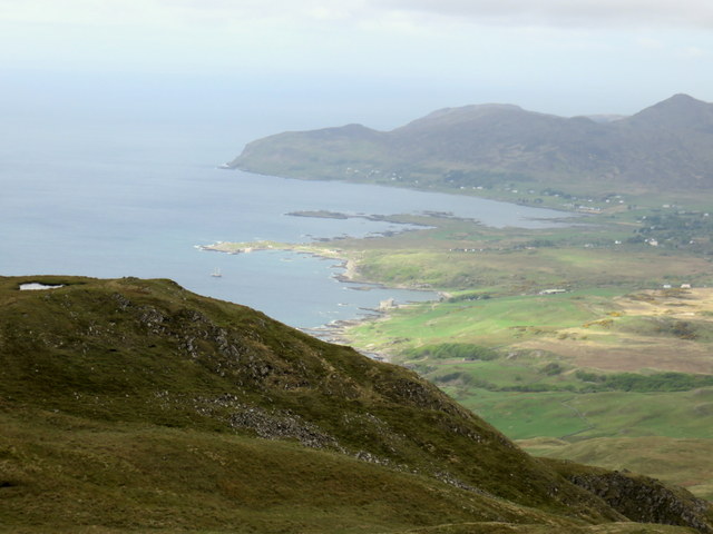
Lovely countryside
Take in the all round views and also note the very dark skies over to the west, the wind is blowing it this way so down.
I took the faint grassy track heading east and as hoped it became a bit more of a conventional but narrow route. Pretty slippy so on the grass a lot.
Track to the road
Meet up with the shooting track and take in the excellent countryside views as you descend.
Mortlach Kirk
Again a tedious road walk back and past the turn in spot before taking the right minor road which is a tranquil walk back to Dufftown. I stop at the historic Mortlach Church, the original kirk originating from the 700’s, some of this one from the 12th century..
I was surprised how quick the walk was considering the apparent distance and terrain covered. A nice walk.

Wildlife: Stoat; Wren; House Martin; Meadow Pipit; Pheasant; Red Grouse.
Time: 3.01
Ascent: 812m
Distance: 13.1k

Monday, 30 April 2018

Beinn Lora cracking views

Beinn Lora Sub 2000 368m
Beinn Lora
What a stunning little hill whose views well exceeded my expectations. After yesterdays solo trip I dragged the good lady along for what was meant to be an easy hill but was rather steep for her in places and over 400m of ascent with all the ups and downs, but she enjoyed the views.
Walk start
I went to do this last year but the hill was closed for deforestation, now all open.
We parked in the car park beside the café, crossed the road to see the blue marker system still in place. There is a newly constructed soft track all the way to the moorland section but already rain making troughs in some of the downhill sections.
Typical new viewing area
Immediately this is a steep hill but the forestry have created plenty of viewpoints, benches etc well needed for some. Some great views already in this clear blue sky. Admittedly the forest destruction is less desirable on the eye but the longer views more than make up for it.
I was looking forward to rushing waterfalls but down to a trickle today.
The small lochan seemed to have pretty much dried up also, the construction to blame. But there is plenty of active spring birdlife to watch.
Lora comes into view
From here the summit can be seen and some people are already up there.
Oban airfield below
At the moor edge the good track has gone and it is a very wet and boggy 900 metres to the trig.
Final pull
 There is a short section of gravel track to climb to get you to the top.

When we reached it another round trig, I wonder if these are local to the area? However, fantastic 360 degree views. 
Mull in background
The most impressive ahead: Mull; the Small Isles beyond; Oban Bay; Morvern peninsula; Lismore. Turn around it is grey skies but there is Loch Etive, Cruachan under cloud and through to the Glencoe range.
Back down over the wet boggy stuff
Walk further on to the western point and it opens up below to Connel, the bridge, the airfield, the beach, superb. We spent some time up here soaking it and the heat in.
We took the short detour to the Eagle's Eyrie viewpoint on the way back, well worth it as some alternative views. 
A great little hill and now time to sit in the sun at the café for well deserved coffee and carrot cake, who loves this country, me.
Wildlife included: Chaffinch; Coal tit; Dunnock; Chiffchaff; Golden Eagle; Meadow pipit; Peacock butterfly.

Time: 2Hr 54Mins
Distance: 4.65m 
Ascent: 1259ft. (426m)


Saturday, 20 May 2017

Ben Hiant Ardnamurchan

View of Ben Hiant from Kilchoan ferry
On our way to Ardnamurchan lighthouse last year we stopped at the viewpoint overlooking the beautiful white sandy beach, Camus nan Geall. Beautiful as it was, it was the golden eagle gliding across the slopes of the hill opposite that attracted me more and I knew I had to get to that top.
There was no time to climb it last year but a return trip to Ardnamurchan made it a goer. By coincidence we were staying on Mull first and the view from our lodge decking was of an impressive hill across the water, maps checked, guess what, fate sealed it was Ben Hiant (Holy hill).
Another coincidence is that it is also in the book ‘The Hughs’ of which I am using to discover different hills. A good and energetic walk is described by Andrew Dempster from sea level. But as the good lady was with me we were going via the tourist route as described in Walkhighlands starting from the high point on the B8007.

That is a cairn?
The start at the tiny cairn is a laugh as this is the cairn, I think it has had some storm or people damage. Two other couples we spoke to had not even identified it and started well down the road. However once spotted the trail is evident, if on the right path it is a clear follow all the way up.
First plateau
An immediate stiff pull up the hillside gets the breathing going and Mrs already doubting the wisdom of her decision. As we reach the first top section I say ‘look those people are on the summit‘, she knows better but it encourages her. Just stop and look around, great views to be had early on and particularly when Loch Sunart opens up.
Middle climb
It is not too difficult a walk, just a steady constant upwards ramble as the path kindly twists and turns around the steeper sections. The only danger were the very strong gusts of wind which were capable of unbalancing you.
Final section and summit
As we look down into the glen below, which is between us and Beinn na-h Urchrach, we spot about 20 plus red deer grazing. Then, as the herd moves more and more deer appear, mainly hinds and calves but the odd stag is spotted, and we count 50 plus at one point, a great sight.
At this point the views of the final section looked a bit daunting to Mrs B but the track remains good. One short scrambling section and then the track winds it way around the back of the hill and before you know it the trig is in sight.

Well worn section
During the final section the views are once again outstanding despite the low cloud and poor long visibility. Looking back down Loch Sunart, Resipole the highest close hill, looking across to Mull with Ben More shrouded in cloud as usual, through the binos I can even see the lodge we stayed in near Tobermory.

Over now looking to Kilchoan and the Calmac ferry from Tobermory is arriving, plus the Ardnamurchan white needle of the lighthouse can just be seen. The islands to the west are also just in view but on a clear day it would be even more spectacular, probably seeing as far as the Uists. Then a couple and dog surprisingly arrive at the trig from a different direction from our route and tell us they have followed the Hughs route. They also say it is the coldest day of their walking holiday and are not hanging about, we concur.
A gentle descent taking in as much of the view as you can, it is well worth it and no need to rush particularly for her knees, she has done well and enjoyed it. You can just see the people ahead of us as small dots to the right. The white strip of beach just visible.
Looking back at the trail and descent
Apart from the red deer and a raven that was it, no eagles to be seen again.
Ben Hiant is a Marilyn at 528 metres. From our starting point it was 1127ft or 344 metres of ascent. Distance walked was 3.01 miles and took us 1 hour 10 to the summit.

Loch Sunart and Morvern

Kilchoan
Another cracking hill with plenty of views to remember. Then it was off to the Natural history centre at Glenmore for coffee and cake, superb. Worth a visit for the unusual local crafted gifts, a lot of money can be spent, be warned!!

Sunday, 16 April 2017

Creag Bheag not quite the runt of the litter

When you look up at Creag Bheag from Kingussie your immediate reaction would be to look at the map for something higher meaning better. It does not impress, it is not love at first sight, it looks like the runt of the litter, the ugly duckling. But dismiss this hill and you are going to miss some really fab views for little effort. Pick the right one as the OS map has a few hills of the same name in close proximity.
Creag Bheag & Loch Gynack
I was looking for a quick hit, whilst the good lady walked over to Ruthven barracks, and yet again the book ‘The Hughs’ provided another gem.
Definitely cooler than yesterday and the Cairngorms had a new dusting of snow. Forecast was for the odd shower in the morning, grey but okay.
We parked in the Ardvonie car park which is free. There are toilets for a 20p charge but one guy tried them and walked away, maybe too early.
I opted to walk from the left side of the car park (beside the loos), clockwise but it is a circuit and the anti clockwise is a bit more climbing effort if you want that, and followed the western road for almost three quarters of a mile.

Camera would not focus in time
It is a tarmac road with a lot of stunning traditional properties and the bonus of a red squirrel which was obviously used to people as it did not flee to far. Mrs B ecstatic that she got up early to see it.
We parted and I headed up the easy to follow track through a wooded area with sheep grazing, keeping a wary eye for my nemesis hill cattle but none to be seen. One buzzard came silently out of the woods to my right closely followed by a second. They quickly disappeared but I could hear their call along with the crows no doubt mobbing them.
Not long at all and you see crags and a bench. Looking back it is a grand view to Newtonmore. Just after you meet the more direct track from the car park and continue up the good stony track, quite muddy to the sides but no issue today.
I am approaching the summit when I spot a bird above, at first I thought it was one of the buzzards but even better a single golden eagle. I watched it make slow circles, at one point it closed in and the feet dropped, mighty talons showing clearly, and I thought a prey dive was on but no it just continued to circle on a thermal, climbing higher and higher until I could see it no more disappearing into the interior of the Monadhliath range. Still that was good.
Far to my right I spot a flash of yellow, focus and two climbers are about to abseil, yellow helmet goes first, then they are gone.

Nearing the top I can see that there are two cairns. I went first to the one on the right which I think was the top cairn but just in case walked across to the other.
Cairn with Kingussie below
All in just 48 minutes from the car park to here and what views. A full 360 degree perspective. This is a spot to spend some time. The wind was cold and I spot another walker at another cairn over to my right. I walk on but as I approach he walks away, strange but obviously wanted no company not even a chat.
Handy windbreak
It turned out that the structure was a stone wind break very welcome as its angle today was full protection. Time to sit, have a drink and an orange and simply enjoy the view. Despite the greyness of the day you still can’t beat it.
The track down is well looked after, constructed with large stones. Mrs B’s knees would have felt it but for me it was good.

The tracks on Carn an Fhreiceadain
I have a clear view of tomorrows destination, Carn an Fhreiceadain along with its other outlying summit Beinn Bhreac. However the massive tracks up and down both hills are not pretty on the eye.
On the descent North Gynack path to Newtonmore can be seen
Loch Gynack is below but not a fisherman in sight, the water looks pretty choppy from up here.
Once down I follow the trail and cross the golf course, narrowly avoiding a genuinely miss hit drive, and wander down the road to Kingussie.

Profile of Craig Bheag from golf course taken in Autumn
A couple of hours gets you up and down at a leisurely pace.  3.9 miles, 248 metres climbed. Magnificent views which would be even better on a clear sky day but nevertheless very well worth doing. Not at all an ugly duckling.

Sunday, 9 April 2017

Cairnsmore of Dee (Black Craig of Dee)


Today was my first outing with Ayr rambling club and very enjoyable it was, a great little hill with challenging terrain, blue skies, superb views and good company, a good day.
There are three hills in the Galloway area with the title Cairnsmore. I have already climbed Carsphain and Fleet so I was glad to add the third. Cairnsmore of Dee is classed as a sub 2000 at 493 metres. The names in this area are fabulous and I believe that Dee is part of the 'Rig of Craig Gilbert'. It is also another hill from the book 'The Hughes'.
View from parking area
We parked just up from the main carpark at Clatteringshaws loch, too mean to pay the £3 daily parking charge. As it turned out the machines were out of order, a free parking day!! There is a cafe and toilets here.

To begin with we took a slight detour to visit Bruces stone, another one? Actually commemorates Bruce's first victory over the English. Then retraced our steps and started our walk proper following the track just across the road from the visitor centre. The aerial mast on Benniguinea is your objective. Follow the forest track for a bit then the muddy track at the first junction until you rejoin the mast track. You can opt to stick to the track. When you break the trees there are good views looking back.

Easy going, gradually gaining height, until just before the mast plunge to the left into the heather, the track has disappeared. There is a cairn at the mast if you want to bag that. 
Benniguinea mast in distance
After a short but very rough walk across this stuff the destination is in sight, albeit still a fair bit to go.
Cairnsmore of Dee appears
There is no proper track and when you do find what you think is one it is very wet, muddy with boots sinking in deep gloop, glad the gaiters are on.
The terrain is typical of this area, deep tussocks, boogy ground, care needed or twisted ankles at best. The best route seems to be low down keeping close to the trees but your choice.
Looking back to Benniguinea
Once over the short descent look up at the hill and pick your route. As mentioned there are short stretches of 'trails' to follow quickly disappearing. New and wet moss clings lightly to large rock slabs, but beware they are eager to give way if you stand on them, another potential danger.

No false summits here once you are up you are there with the trig and cairn almost together. A small new cairn stands a bit away not sure for why. A couple of the ladies decide the height gained was not enough so onto the trig they clambered, good on you.
Mini cairn
The views over the Galloway range are superb, Clatteringshaws loch in view below, the Merrick straight ahead, Corserine to its right and Cairnsmore of Fleet at 8 o'clock.

After lunch in the sun, we simply follow the same route back although as an option the Hughs book describes a circular route. Once on the main track we met families lightly dressed in summer gear, t shirts etc looking at this bunch of loonies heavily clad wondering where we have been.

Very little wildlife about today, a pair of ravens, some meadow pipits but we did get a red kite as we drove out.
Distance walked 7.28 miles, with 483 metres of climbing.
I enjoyed it, glad I was there, better in than out.