Showing posts with label Ayr rambling club. Show all posts

Monday, 20 August 2018

Ben Vorlich another Munro with nae view

Hill: Ben Vorlich Loch Lomond
Category: Munro
Height: 943

We started at Inveruglas, the parking machines broken, yahoo. A muggy day, hot down here but very low clouds.
Lower flank of Ben Vane
We took the standard route along the road then under the railway bridge onto the Loch Sloy track. A few cows on the path but not interested in us. The slopes of Ben Vane flank our right but tops not in sight.
Rock steps to Vorlich
After about 45 minutes of a walk in we reached the start of the climb. A group can be seen a bit further up the very steep slopes.
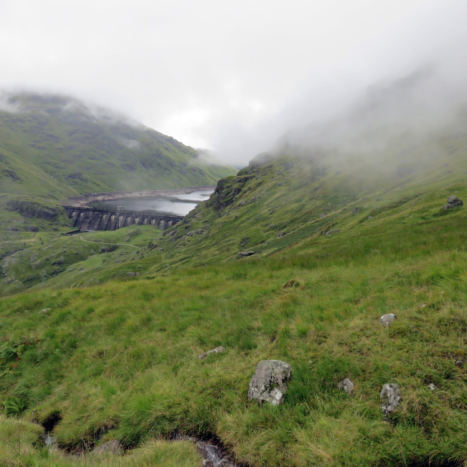
Loch Sloy dam
The initial stages are solid stone steps which aids progress but with the muggy conditions the sweat is pouring off me. This is a steep climb. Plenty of opportunities to pause, regroup, look at the Loch Sloy dam and then onwards and upwards again.
Well into cloud
The gradient does ease at times but all is relative it is still hard going. We are also now fully into the cloud so just head down and grind it out.
Track all the way
The walking is now easier and as there is a good track all the way you cannot get lost even in these conditions. Thankfully we come across the trig and cairn. The true summit is some 200 metres away but it could be anywhere as we can only see about 10 metres.
Trig & cairn not the summit
We go across to it and its larger cairn, the rain comes on proper and we shelter for a quick lunch. A raven appears out of the gloom wanting food, must have good vision that one.
Cloud thinning Loch Sloy below
On the descent the clouds thin and we actually get a view of the loch.
A bit further down and Loch Lomond appears. The walkers coming up are probably going to get a view, aargh.
Descent track
The track makes for a quick descent but the rock steps are jarring the old knees. From the bottom the tops can now be seen, clouds gone lol.
Just the long walk back wondering if the machines have been fixed and if a parking ticket is on the car.
After 7 hills in 8 days my legs are feeling it but it was a good outing despite the weather.

Wildlife: Raven, Buzzard, Goldfinch, Large White Butterfly.
Time: 5.21
Ascent: 3158ft
Distance: 8.72m 

Sunday, 5 November 2017

Scaw'd Law Durisdeer a beautiful Autumn walk

Durisdeer Kirk c1699
Today’s walk was with the folk from ARC with Scawd Law the objective, a Donald category at 663m This walk starts at picturesque Durisdeer village, via some very narrow single track roads, take care, some parking beside the beautiful church. The church is from 1699 and contains the original pews, need to look in next time if open. Its grandness is in tow with nearby Drumlanrig Castle. Like much of rural Scotland this area is steeped in history.
Opening track Turn & Well hills on left
We then followed the slowly ascending farm track through some beautiful rolling border hillsides There are great views of Black, Turn & Well hills on the left. This track runs slightly higher than the old Roman road to Clydesdale, which can be easily seen below, also passing the old fortlet, dated to the Flavian period from metals found, whose grassy mounds also stands out clearly, today protected by a herd of coos, signs warning of the bull.
Fortlet in the middle of snap

This area is a grouse moor and early on we sprung quite a few of them bursting out of the heather.
Above Well hill there were an unusually high number of birds circling including: ravens; red kites; buzzards, all scavengers, very odd but later we probably found out why.
Durisdeer hill
After a short refreshment break, we tackled the steep ascent onto Durisdeer Hill. We followed the fence for a while then opted to follow a quad bike trail up the slippery, muddy slopes, but I have had a lot worse terrain recently.
The weather was very good considering the forecast with excellent all round views.
Getting to top of Durisdeer

From there we follow the fence line across the open moorland ridge heading to Little Scaw’d Law and then Scaw’d Law itself, today’s highest point. You could take a more direct line across the moor but really unless you need to save time just follow the fence, particularly if the weather closes in. At the top no trig, nor cairn so GPS reference taken to confirm highest point.
Looking back to Well Hill

Again time taken to take in and appreciate the views. To the south the Solway & Criffel. To the west the Galloway ranges. Just to the north Sanquhar and eastwards the Moffat range, quite spectacular. 
Looking to Wedder Law
More red kites can be seen along with a few hares, coats already turning whiter.
Next we drop down to cross a track and make the short climb onto Glenleith Fell. 
Typical landscape, Well hill and the pass to Clydesdale
The moorland walking is awkward enough but the amount of old wire left behind by the fence builders, to trip you up is disgraceful, shoddy workmanship.
This is followed by a steep grassy descent to the shooter’s bothy near Blackhill Moss, where we had our lunch break. A scenic spot particularly in this weather, otherwise indoors.
Death valley
Just as we finished eating two land rovers drew up and out popped a gang of guys with flags, beaters for a shooting party. Despite us contacting the estate beforehand and being told no shooting today, there obviously was and they would not let us walk down the track until the shooting was over. We could have forced the issue but why take the aggro, we are here to enjoy ourselves. The weather had changed for a thankfully just a brief spell: very windy; very cold and some rain, not the time you wanted to be hanging about and I had forgot my gloves so cold hands.
We walked slowly behind some beaters, it turned out to be a partridge shoot. There were plenty of beaters and plenty of dead birds. Considering how low the birds fly the shooters can hardly miss them, firing a spreading buckshot into the sky. Slaughter not sport. The number of carrion birds were again evident looking for the missed carcasses. Would the many Labradors and spaniels criss crossing the ground leave them any? 
Autumn sun
I suspect that they had been shooting earlier nearer the beginning of our walk hence the large number of carrion eating birds spotted.
Slowly we descended the Glenaggart track (valley of death for the partridges) until the shoot was over and then back to Durisdeer. Blue skies once again. 
Durisdeer village
Looking at the graveyard some of these stones are ancient, circa the original construction? A few interesting stories on these stones, another reason to spend some time here.
Overall a really good walk in a beautiful part of the country and as always good company and chat to pass the time.

Time: 4hrs 25min
Distance: 7.68m (12.36km)
Ascent: 1788ft (545m)

Sunday, 24 September 2017

Now I know why it is called Grey Hill

Byne Hill from the start
It was too much to hope for that I would get 3 walks in a week all in good weather. Out with the ARC group today, the original plan was a Culter Fell horseshoe but last night it was cancelled due to bad weather, take your pick: high winds, mist, fog and rain not worth the long drive. A local substitute walk was put in place down by Girvan, walking Grey hill and then followed by Byne hill. Grey hill is a small Marilyn/Sub 2000 category at only 297 metres.
Ailsa Craig from the start
I had suspected, but now know for sure, why this is called Grey hill. The forecast was windy with rain around 2pm. On the radio Calmac had already disrupted sailings. As we parked up the reality was that light rain had already started and the tops were already covered in mist. Good camera packed away in a dry bag so mobile snaps only, sorry for quality.
We left the car park and walked south alongside the road cutting behind the nursing home before crossing the busy road and starting the walk proper. 
I suspected that this walk could be a mud fest and I was proved very much right. It didn’t help that a herd of cows had churned up the already boggy ground it was ankle deep areas of sludge in places with little options, the joys.


Follow an obvious track that initially heads up the flank of Byne hill. We now find ourselves amongst a large herd of horses who thankfully did not seem too concerned by our presence and then reached the memorial monument. This old monument, apparently to a James Craufurd, looks out from the Byne Hill across water to Ailsa Craig.I was told that he was some local worthy who was involved and possibly died in some far flung war, apologies if incorrect.
After going through a metal gate there was fresh evidence that the coos were around. We had to leave the path as it was so churned up. 
Dreich hollow
So an extra small hill (I think Mains Hill) had to be climbed, up and over, follow the hoof marks before descending through even more churned areas, weave through sharp gorse needles to a hollow to start Grey hill proper. The wind was now gusting so hard a couple of our walkers were almost blown over on the small hill, bad omen for further up. Rainbows over Girvan.

With the wind and rain there is not a lot to say about Grey hill it was a trudge, mainly following the quad bike track, a walk to be endured rather than enjoyed. 
Track to Grey Hill
At the trig point there was a misty view of Knockdolian and out to sea its twin volcanic plug, Ailsa Craig. On a clear day the 360 degree views would make the muddy walk worthwhile but no sign of Ireland, Arran etc today.
Grey hill trig Knockdolian in distance
We descended by following sheep trails down the leeward side, more or less retracing our steps to get back to the bottom of Byne hill. The weather has not relented, it was not my favourite walking day but at least it was not cold.
A short clamber gets us towards the top and guess what we meet the coos. Quite a large herd, some with young calves so all be wary. A few of them decided to run for it but a couple held their ground and we had to pass very close. The rest of the herd stood firm and gave us a good stare.  
Byne Hill looking back to Grey Hill
We continued the short climb upwards to the summit where there is a direction indicator and good views down to Girvan and out to Ailsa Craig. It actually looked like the sun was shining on parts of the town.

The walk continued along the hilltop before making a steep descent down a wet and slippy grassy slope. Byne hill caravan park sits below along with a less attractive scrapyard.

The obvious descent from here is discouraged as the local farmer does not want walkers across his land, he can’t stop walkers but no need for aggro. So, we now headed west and cut back along the flank of Byne hill, following a very faint route through ferns before finding a half hidden style.

Clamber over this and then cut across a field to meet the track we started on. Right at the end there was a field of pretty sheep that I had not seen before, later identified as Balwen Welsh mountain sheep. 

Not a day for other wildlife.
It was a good few hours of exercise in good company but I can’t see me rushing back too quickly to this terrain, certainly it would need to be a day with visibility guaranteed to get the views.
Time: 4 hours 23m
Distance: 7.1 miles (11.43km)
Ascent: 1312 ft (400m)


Monday, 18 September 2017

A clear day on Corserine & the southern Rhinns of Kells

It was a belated but welcome opportunity to join the guys ‘n gals of ARC today for their walk to Corserine and its southerly Donald’s. This should have been my 7th walk with the group but mainly due to weather it is only my 3rd, still got the next two weekends in the diary as well. It was a bigger than usual group for an A walk today, 21 bodies.
Corserine is a Corbett at 814 metres the highest point of the day although with the ups and downs to the other hills we were probably touching 1000 metres of ascent. This is the southern section of the Rhinns of Kells ridge.
The weather forecast was decent so fingers crossed. A 45 minute drive got us to the walks start. We parked in the decent car park at Forest Lodge, midges’ out but not hanging about here for long.
A decent walk in to the hill, along forest tracks all unusually named after the Olsen family and various other people. We followed the track ‘Robert Watson road’ until the path forks right. Follow the now very boggy track through the woods, cross a stream, until you reach the deer fence/stile, roughly 2.5 miles in.
Polmaddy Gairy on the right
Now you are out in open moorland typical of this terrain. Follow the faint track upwards, initially heading to your right then back. This gets the lungs going and the group is starting to spread out. The ridge is soon reached via Polmaddy Gairy but be sure to stop and take in the views behind you. 

When the top is reached it is now a broad plateau, there is a large stone cairn here but this is not the top, you can see the trig point some way ahead which is the true summit of Corserine, 4 miles from the start of the walk.
Walking towards Corserine trig
To the north there are great views of Carlin's cairn and the rest of the ridge including Meaul and Bow (see earlier blog). 
Carlin's Cairn in the sun
However, we are heading south and there are equally excellent views of our route heading firstly for Millfire, then onto the Donald’s of Milldown & Meikle Millyea.
The Southern Rhinns of Kells
The air clarity was superb so long distance viewing in all directions, plenty of time to try to identify many of the sights.
Although dry the wind had picked up and at this height the chill factor was high so most of us were adding another layer or two.
The walk along the ridge and across the plateau is generally good going, the way ahead is obvious in today’s conditions, just keep dodging about to avoid the many wet sections. This section of the ridge is about 3 miles.
The Merrick
The views of the Merrick and the many lochs in the area are a highlight, constantly changing as the light changes between the sunshine and the clouds but this is what it is all about. The Solway can be seen as can the hills of the Lake District.
Again don’t forget to look back as the ever changing landscape has its rugged beauty on a day like this.
Another stone wall provides guidance onto Meikle Millyea.

The descent is as expected boggier and you are unlikely to keep out of all the water and mud. There is a path of sorts but mainly you are you are following the decaying stone wall. When you finally move away from the wall to make the final section to the forest there is a very steep and slippy section requiring minor scrambling skills. There were a few muddy jackets and trousers after this. 

Finally another deer stile and a short walk through the forest to another road/track (some Professor). Then about a mile and a half back to the car park.
Very little wildlife seen today, highlight was a merlin. Some ravens and a solitary red grouse. 
Loch Dungeon
An excellent walk obviously assisted by the great viewing conditions. On a day like this hill walking in Scotland cannot be beaten. Hopefully more of the same for Ben Ledi on Tuesday and Culter Fell on Saturday.
Time: 5 hours 57m
Distance: 10.55 miles (16.98km)
Ascent: 2957 ft (901m)


Saturday, 15 July 2017

Craigenreoch and Haggis Hill

It was good to get back out with the ARC once again but what a weather difference from warmth of the last outing. Last night I was sitting in the back garden, sun lotion on with a cheeky beer. Not today, totally different, a grey and wet day forecast.
The start on Rowantree hill
Still the group were doing a circular walk encompassing quite a few hills including the Marilyin, Craigenreoch (565m), along with its outlying hills Rowantree and the quaintly named Haggis hill. Sadly not many quality photos as normal as the conditions were just too wet.
From Ayr we drove past Straighton southwards on the Glentrool road until we reached the Bell memorial, then a sharp right leads you onto a single track road for about half a mile and a parking area on the left has space for 4 or 5 cars.
The rain had already started so wet gear on. Immediately into the walk and a stiff pull gets the heart and lungs going but it is not too long before the top of Rowantree hill is reached.
Craigenreoch trig ahead
From the top and in the distance the trig point of Craigenreoch can be seen in the gloom. It is an easy and straightforward approach, but very wet underfoot walk. The record rain over the last has been well held in this mossy moorland although it is probably never fully dry underfoot.

As we reach the trig the rain and clouds ease briefly to let us see on our left the Solway glistening in the distance. On our right can be seen the ridge, including the small trig on Haggis hill, that we will be returning via and directly ahead the trees that will be our turning point.
The very brief weather interlude ends and we continue by following the helpful fence as well as the shepherds quad bike trail. Everyone is sopping wet by this time but the banter is good.
Typical terrain
On the route we topped Polmaddie, Pinbreck & Changue hills but I was not getting my map out to check as we walked. A short up and down from Changue and we reached the single stone trig of Haggis hill. In some ways the single stone seems more authentic than the piles commonly seen. 
Haggis hill trig
The weather has eased and we start to get views again particularly good looking down to the meandering Balloch burn. A big puddle is in view, Loch Bradan I think. I did check later and apparently the hill was named because it looked like a haggis!! Not in my eyes but a good name nevertheless.
Balloch burn
A very steep descent on the wet grassy slope keeps everybody concentrated and after fording the fast running Balloch burn, some more even wetter feet, but at least it was lunchtime. Very pleasant break it was beside the noisy running water. If you walked back up the glen you would reach the ‘Linn of the Darkness’ waterfall, what names!
Looking back to Haggis hill
A short squelchy moor walk followed and a then short but sharp climb brought us to the road that we left our cars on. This road is on the pass of fabulously named ‘ Nick of the Balloch, a historic smugglers path. You could follow the burn up to the waterfall at the Witches Bridge, then follow another quad bike track instead of taking the road. 
Final stretch
Back to the cars and the inevitable comparisons about which brand of wet gear performed and which didn’t. My newish Jack Wolfskin should have performed but I was wet on the chest. It is possible that I did not have the zip fully engaged so will try again but still disappointing.
All in all a shortish and straightforward days walk. Good company but crap weather. I will need to return on a better day to fully enjoy the landscape.
Ascent 1588 feet, distance 6.38 miles and 4 hours including stops.

Sunday, 9 April 2017

Cairnsmore of Dee (Black Craig of Dee)


Today was my first outing with Ayr rambling club and very enjoyable it was, a great little hill with challenging terrain, blue skies, superb views and good company, a good day.
There are three hills in the Galloway area with the title Cairnsmore. I have already climbed Carsphain and Fleet so I was glad to add the third. Cairnsmore of Dee is classed as a sub 2000 at 493 metres. The names in this area are fabulous and I believe that Dee is part of the 'Rig of Craig Gilbert'. It is also another hill from the book 'The Hughes'.
View from parking area
We parked just up from the main carpark at Clatteringshaws loch, too mean to pay the £3 daily parking charge. As it turned out the machines were out of order, a free parking day!! There is a cafe and toilets here.

To begin with we took a slight detour to visit Bruces stone, another one? Actually commemorates Bruce's first victory over the English. Then retraced our steps and started our walk proper following the track just across the road from the visitor centre. The aerial mast on Benniguinea is your objective. Follow the forest track for a bit then the muddy track at the first junction until you rejoin the mast track. You can opt to stick to the track. When you break the trees there are good views looking back.

Easy going, gradually gaining height, until just before the mast plunge to the left into the heather, the track has disappeared. There is a cairn at the mast if you want to bag that. 
Benniguinea mast in distance
After a short but very rough walk across this stuff the destination is in sight, albeit still a fair bit to go.
Cairnsmore of Dee appears
There is no proper track and when you do find what you think is one it is very wet, muddy with boots sinking in deep gloop, glad the gaiters are on.
The terrain is typical of this area, deep tussocks, boogy ground, care needed or twisted ankles at best. The best route seems to be low down keeping close to the trees but your choice.
Looking back to Benniguinea
Once over the short descent look up at the hill and pick your route. As mentioned there are short stretches of 'trails' to follow quickly disappearing. New and wet moss clings lightly to large rock slabs, but beware they are eager to give way if you stand on them, another potential danger.

No false summits here once you are up you are there with the trig and cairn almost together. A small new cairn stands a bit away not sure for why. A couple of the ladies decide the height gained was not enough so onto the trig they clambered, good on you.
Mini cairn
The views over the Galloway range are superb, Clatteringshaws loch in view below, the Merrick straight ahead, Corserine to its right and Cairnsmore of Fleet at 8 o'clock.

After lunch in the sun, we simply follow the same route back although as an option the Hughs book describes a circular route. Once on the main track we met families lightly dressed in summer gear, t shirts etc looking at this bunch of loonies heavily clad wondering where we have been.

Very little wildlife about today, a pair of ravens, some meadow pipits but we did get a red kite as we drove out.
Distance walked 7.28 miles, with 483 metres of climbing.
I enjoyed it, glad I was there, better in than out.