Monday, 15 May 2017

Early morning walk on Speinne Mor Mull

Hill profile from the west
An early start this morning as the weather forecast was predicting rain by lunchtime. I was awake early anyway with the dawn chorus and as such was at the start of the hill for around 7.30. Today’s objective another Marilyn on Mull, Speinne Mor.
Grey and overcast, but not cold, anyway full rain gear on in anticipation.
There is parking on the left immediately after the last loch but take care not to stick out, it also acts as a passing place.

Walk starts here
The fence and stile are immediately evident, go over and start following the track. This is clearly a well used hill from the number of footmarks dug into the muddy uphill track. The heads of the ferns are coming through, later in the year the track might disappear when they mature.
Overall there is no difficulty on this walk in today’s conditions but up top it is a very remote moor, so on a low cloud bad weather day it could get interesting, particularly on the summit plateau. This is a rather barren landscape. Not even sheep grazing to bring a farmer up. The only other person you are likely to encounter is another walker, but nobody at all around today. Still the positives, the sound of silence and isolation, apart from the sounds of wildlife and my breathing.

3 lochs plus S Airde Beinn
The stiff pull got my breathing going and the good views over the 3 lochs on my left kept me interested. Yesterdays walk S Airde Beinn is the high point. An early morning angler is rowing a boat out, he was not there when I returned, maybe caught his catch or too windy. A couple of meadow pipits were my only other companions.
Summit plus Loch Frisa
Once over the initial climb the terrain flattens out at Sron na Beinne Creagaich and you get your first view of the objective, it looks a long way away in this light. This section was generally good walking but still boggy in parts, enough to go ankle deep in mud at times. The weather has been remarkably dry so I can imagine that this would be very different after a wet spell.
There is still a good track to follow, you lose it at times but soon catch it again.
Loch Frisa is clear on your right, I was hoping to see one of its resident sea eagles but they were no doubt sitting on their nest waiting for the weather to improve.
A line of rusting fence poles gives another line to follow, particularly handy if the visibility was poor.

Final climb
Now cross the very small burn, Allt a Chiogaid, which flows from Lochan Dearg, of which you will get better views soon.
Open summit moorland
Another short uphill section continues until the ground levels off. Almost immediately there is a very small pile of stones where you turn left and follow the faint track, moving uphill across the hill. Don’t worry if you miss it, I did, saw it on the way back. Just head up towards the nearest high point and keep doing that. It is a teaser of a top, you keep thinking that you are there but the trig is still a good bit away.
Ferns out at trig
Finally I reach the stone shelter which circles the trig, 444 metres and it has taken me 1 hour 18 minutes. For a short time I have had the view down to Tobermory on my left. Sadly with the poor visibility I can only imagine the stunning 360 degree distance views that I would get on a clear day, not even Ben More could be seen. Just as I took my trig snap the pitter patter of rain began to hit my bare head.
Lochan Dearg
The return is by the same route but as always that is the time for me to take in the views and the landscape. On this bare moor I fully expected to see red deer but not one spotted until I was almost back down, grazing near the loch. A skylark rose and a grouse called but that was it.
A good view of the lochan but too far across that ground to explore.
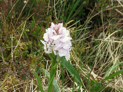
Marsh orchid?
There were a couple of orchids that I spotted, one a pink base with deeper spots which I think is the early marsh version, happy to be corrected. The other pure white which I‘m told might be another early marsh variety. Then I came across this rock with the most amazing colours, what a sight, a pleasing end to the walk. Time for brunch.
Colourful rock
Glad to say the rain did not come to much but the long views remained poor.
Trip stats: Overall walking distance 5.68 miles (9.14k)
Time: 2 hours 42 minutes
Ascent: 1213 feet (370m).

No comments:

Post a Comment