Thursday 13 March 2014

Cycle Ayr - Culzean

It has been a great 3 days. The blue skies and milder weather just makes everyone feel so much better. 2 rounds of golf without 4 layers of clothing was just superb. I also managed 3 bike rides the best of which is this post.
The weather forecast was excellent particularly with the most important element, minimal wind, I decided a coastal ride was on. I knew the views over the sea were going to be well worth the effort.
My route started at Ayr shore car park. Busy for 10am on a Wednesday. A gentle ride along the Ayr seafront eases you in gently followed by a short off road climb, I thought this was all tarmac, got the heart and lungs going. The track continues along a rutted and muddy farm-track, not the best on skinny tyres, but with care I got through the puddles.
The track joins the coastal road just before the old Butlins caravan park, I can't remember who owns it now. You are on a coastal road so be aware of the traffic. It is a gentle climb up towards Dunure but already the views are brilliant over the Heads of Ayr and out over the sea to Arran. Peregrine falcons are regularly seen at these cliffs. If you are on foot the walk along the beach, tide permitting, is a good walk.
Around this point there is a road that takes you over the Carrick Hills to Maybole that can be explored but today I am straight out and back along the coastal road.
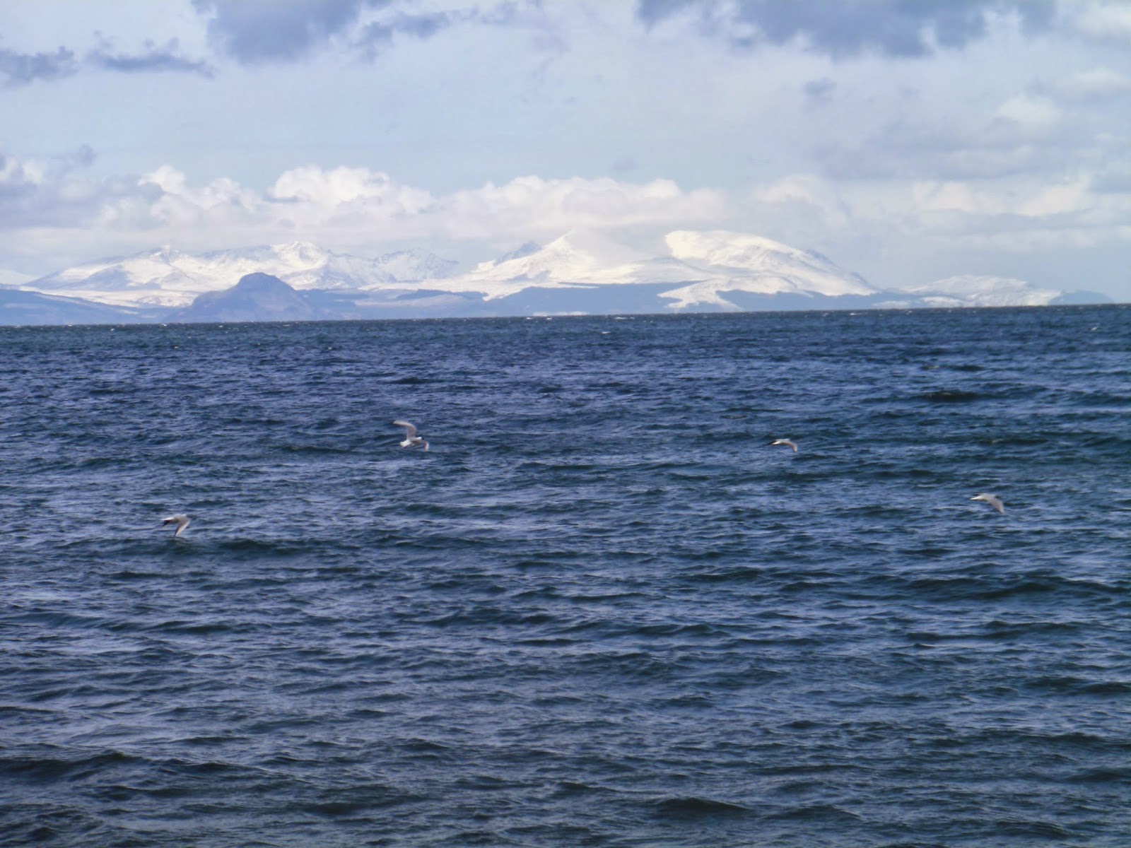
Arran still holding snow

It is a steady climb up to the Dunure cut off. For those cyclists fitter than me then opt for the descent into the village of Dunure. There is a super pub, Dunure Inn, which has great seafood ( n.b. if you phone in advance, as I once did, they caught a lobster for me that morning ), but remember you have to cycle back up to the main road so not too much food & drink. Dunure village is the location of a ruined castle which has an interesting history, for more info look it up on Wikipedia.
Now another steady climb which for me its time to get out of the saddle for a bit, but not sweating yet so it could be harder. Plenty of lambs in the surrounding fields being closely monitored by crows and also a large raven that flew over my head. Not good news for the lambs unless their mothers are attentive but even then they can be powerless to stop the birds. Sadly I have seen them take the eyes out of newborn lambs but that is how nature works.
Views are still excellent, perfect cycling conditions, who needs to go abroad?
I now can see Culzean castle in the distance a nice sight. A brief stop at a parking slot to take on board some drink, dried apple and nuts as well as taking in the wonderful views.

Culzean castle from beach

The next climb is probably the hardest of the day for me but I make it to the top. You can take another detour down to Croy beach which is a lovely spot but another climb back up again!!
The end of this climb takes you to the Electric Brae which is an Ayrshire tourist destination. Basically it is an optical illusion whereby cars seem to go uphill when indeed it is downhill. I believe it is due to the cambers of the road. My kids used to get out of the car and roll a ball to see where downhill was.
This section of the road is over when you arrive at the T junction, left for Maybole, right for Culzean. A pleasant straightish road takes you to Culzean castle where there is an entrance charge for cars but cyclists straight through. Plenty of pheasants in and around this area and a pair flew straight out across the road, not close enough to cause me to crash but interesting nevertheless. Culzean castle is an impressive building and worth a look around. Depending on when you visit the cafe may or may not be open so make sure you have some rations. There are very impressive grounds to take a stroll around and for another day some easy coastal walks that show up the beautiful hidden beaches in the area particularly at low tide.

How about this for a cracking little beach with Ailsa Craig in the background. 
That was enough for me today and the return was a reverse of the above. A wonderful bike ride on a scenic route. I feel good!!!
Looking north to Croy beach from Culzean castle
All told my trip was around 27 miles which was nice for me and definitely easier going back. On the outward route the climb from sea level reaches 490 feet but there is a good bit of up and down to give you a higher total altitude of climbing. The last photo looks back at some of the coastal route we have just cycled. For younger fitter legs you have options to extend your ride. If you want to you can continue past Culzean to Maidens and Turnberry but you then meet the busy A77 if you are going back to Ayr that way. At the T junction you can go to Maybole and come back over the Carrick hills route or go back to Ayr via the A77.
But my recommendation is that you do this coastal ride and enjoy the magnificent scenery.

Thursday 6 March 2014

Barassie beach to Bogside flats


Looking out to sea from Barassie beach
Hi I have been out of action for a while but back on my rambles again so the blog continues. It has been an interesting winter, lots of wind, lots of rain and very little sun. Luckily today's short walk had some real sunshine and more of that later.
Lappock Rock
This walk goes from Barassie straight along the beach to the Irvine bay flatlands. You can make it more of a circular route by heading inland for your return journey but today I was content with a straight out and back route. In total the walk is about 7 miles, great for a lazy Sunday or short family walk, no hills involved unless you go up to the dragon.
It was a calm, no wind, but cloudy day, so I wasn't sure what the weather would throw at me. The met office said dry so waterproofs were packed in the rucksack. Out at sea it was also flat calm as you can see from the two shots.
In the 1st photo there is a small fishing boat to the left. I think this might be the controversial boat that fishes for razor clams by electrifying the seabed. I had not seen the boat for some time as I thought it had been banned but possibly not. What I do know is that you always found razor clam shells on the beach but this is now a rare occurrence over the last few years. A coincidence I think not. 
Barassie sand dunes collapsing
Barassie sand dune protection falling apart
In the 2nd photo you can see that the light has changed as I took this picture of Lappock Rock, snapped looking more to the south (Ailsa Craig in background) whereas top snap was a northerly picture. Lappock rock is a shipping hazard warning beacon. Troon and Irvine were significant working ports in the 18th century but the rocks are still a danger for pleasure craft.
The winter storms have caused havoc all over the country. We have had our share as the high seas swamping the beach line has caused the dunes to cave in. The top photo highlights the collapsed traditional sand dunes. Behind the top line lies Western Gailes golf course which is not in any danger yet but in a few years who knows. In the past one of the dune restoration projects set a line of these concrete pipes but as can be seen these are now being destroyed by the pounding high tides.


Not all of the storm damage has been to the beach structure, sadly the casualties include the wildlife. There have been press reports all around Britain of the high volume of dead migrant birds found washed up on our shores. The main reasons are exhaustion battling the storms and starvation. I suspect this razorbill falls in the exhaustion category. Not being any sort of expert but having a close look this bird seemed in reasonable body condition so I don't think starvation was the issue. It has also just arrived on the last tide as the gulls or crows have not yet feasted upon it.
Looking north to Dalry hills
Walking along the beach the sun appeared briefly and illuminated the wind-farm on the Dalry hills. I'm saddened by these monstrosities which totally spoil the great beauty of Scotland. I could understand the case if we were reaping the benefits of cheaper energy but that is not the case. The massive subsidies and guaranteed earnings make only one winner here. One could argue that the Dalry hills are not the most scenic. In some respects I would agree but they do have a rugged beauty, fitting with this landscape. One thing I am sure about is the view was a dammed site better without them being there.
During most of this walk you are constantly looking ahead or out to sea with the views across to Arran. Many people find the experience of walking beside a gentle sea soothing and relaxing. If you have your binoculars you can spot almost every type of seagull on the same day as well as many other wading birds. Today I watched a male ringed plover go through its mating ritual with two females. Not sure if they were impressed but I was delighted with it.
Irvine bay estuary

At the end of the beach, approximately 3 miles walking, you arrive at the entrance to Irvine bay. Keep your eyes open as Roman coins were found in the grassy area nearby, albeit many years ago. I have avoided the picture of the carpark but I do show where the tide floods through at the beginning of the estuary. As can be seen the walk way has collapsed due to storm damage.
Bogside flats
Irvine town in the background
A short walk brings you to the area known as the 'Bogside flats'. This is a significant spot for birdwatchers. Many migrating birds will use this area as a stopping off point. It is fairly safe for them with very restricted access for people. Additionally when the tide comes in it can come in very quickly and cut off anyone foolhardy enough to be far out on the flats. Today I spotted over 50 widgeon arriving in 3 flights. Teal and mallard were grazing the water line along with redshank, dunlin and sanderling. 2 shelduck were at the far end. The largest of the ducks, in fact almost a goose, and so beautifully coloured. A huge flock of peewits arrived, gosh when was the last time I saw so many in one place? Just ahead of the sunken boat a grey seal watched me coming closer & closer, seemingly unconcerned, but as soon as I raised the camera it slid back underwater not to be spotted again. It is not uncommon to spot deer out on the flats. Raptors will fly over at speed trying to raise the birds and pick one off for lunch. At this point the estuary splits into 2 rivers, the Irvine & the Garnock. In late summer and autumn both are good salmon rivers.
Where the estuary becomes the River Garnock

The harbour area used to be a hive of activity for sea fisherman but it is rare to see them now. The occasional mackerel and mullet shoals will attract some guys.
The harbour used to be a vibrant active place and it is a shame to see it so quiet. The wildlife appreciate it of course.
The area has been a housing renewable scheme and I think that they have done a good job.
There are a few cafes and pubs near by so its a good point for a refreshment before you head back to Barassie.
Irvine Bay's dragon overlooking Irvine beach was the inpiration of 'DarkIsle'
Looking south from the dragon
Rather than return exactly as before I headed across to the Magnum beach park and walked the short distance and went up the short incline to the stone dragon. The dragon I believe is a nod to our Viking past. The dragon is meant to scare off any passing longboats. 
As always a little bit of effort to get the elevation gives you a totally different perspective and the views all round are impressive.
The first photo here from the dragon is looking south towards Barassie & Troon.
Looking north from the dragon
The second photo looks north back to the estuary. The Saltcoats peninsula can be seen in the distance to the right and the island of Arran on the left.
If you stay on this side there is a path that will take you along to Western Gailes golf club and shortly later brings you back onto the beach and the views across to Arran.
There is a right of way alongside the golf course if you wish to stay on this side but please act responsibly as this is a private course and stray balls are always a possibility on a golf course.
For the next half an hour or so the sun broke through and it was positively balmy, for us an early summer day. I was wearing my Craghopper Kiwi pro walking trousers which are fantastic. But they are a winter trouser and are lined, normally I say brill, but in this heat my legs were beginning to sweat. Never mind the sun is a cheerful thing and the smile & pleasure it brought outweighed the slight discomfort.

Arran

Looking north from Barassie beach
Above the island of Arran with the snow capped peaks mingling with the clouds. A bit surreal considering the heat.
Finally the end of the journey and the view looking north towards Irvine. A cracking little walk, took me about 2 hours 30 mins but I was stopping frequently to watch the birds and take some snaps.
Try it for yourself you will enjoy it.