Wednesday 22 February 2017

Loudon Hill Short but Sweet

View from the carpark
The typical recent weather of strong winds and heavy rain disrupted my plans today. I originally had planned to climb the Graham, Blackcraig Hill in Glen Afton, but looking at the MET office rain forecast I would be very wet and cold without seeing any decent views.

Desperate for a short morning walk I drove out to Dalry to revisit Loudon Hill, another volcanic plug, short climb with great views. It is also a Hugh, I am ticking these off from the book even if I have been up them before. Rain was off and on during the drive but when I caught sight of it I could see the top so good enough. The last time I walked from Dalry (see previous blog) but today it was to be simply the hill.
Bridge over the River Irvine
I parked the car at the standard carpark, windy but dry. I opted to do the circular route going south around the back of the hill then ascending to the summit. I did not have my walking poles with me but they would have been a good idea. At least there is a wooden bridge crossing the head of the River Irvine. The ground from then on was pretty muddy and where it was just earth very slippy. Along with a heavy leaf covering and hidden greasy rocks this was a lot more awkward than it should have been.
Looked up at the crags which are used for introductory rock climbing but nobody around today.
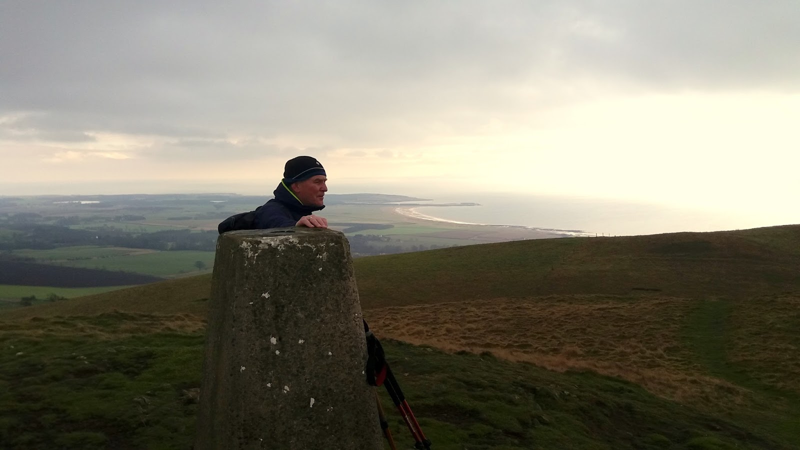
Slippy slopes
Around the back of the hill the track is leaf covered and I find these are also a cover for deep gloopy mud. Boots well covered in the brown stuff. Up the slope hands were needed to stop me sliding on the muddy surface, did not expect to be scrambling today. Breaking out to the grassy summit a hail shower greets my arrival. 

At the trig it has eased but still very strong blustery winds. Still, I took 10 minutes or so to take in the views which even today are superb, except for the enormous amount of wind turbines. Even pockets of blue sky around. Looking south east it looks grim, glad I didn't head that way. Not many places that you can get views like this after less than 30 minutes effort.
Another slippy slide back down and followed the track round the other side and back to the car park. 
Is it summer, no.
Actually there are now pure blue skies above, quite summer looking, if not feeling. A couple of minutes later back to grim grey. It is a dramatic little hill and does look like a granite stopper.

I spend some time at the information board and enjoying the Spirit of Scotland sculpture. This area is packed full of history with links to Robert the Bruce and William Wallace, Covenanters etc. Read all about it. Then the rain came on again and time to go home.
Just over an hour up and down, about 350 feet climbed, short and sweet and I feel better. Storm Doris coming in tonight!!

Thursday 16 February 2017

Forth & Clyde Union Canal Kilsyth - Falkirk

An example of the signage along the towpath.
As Mrs B was away I took the opportunity to complete another leg of the canal walk.  After 2 gloriously blue sky days it was back to a grey cloudy one but never mind this walk is all on the flat.
I decided it was light weather gear today but when I stepped off the train at Croy it was a different world from home, very cold and very low cloud.
This time I headed straight to the Auchinstarry basin sticking to the main road. Last time I took the easterly cut off and today this would have meant a double back looking across the canal thinking I should be over there.
Cold grey start, cyclist in yellow at benches
A cyclist was already sitting on a bench enjoying a snack. Swiftly into stride, mainly to warm up, I was off heading east towards Falkirk. Workers in the hills were clearing land with fire, no grouse moors here. Some barges were puffing smoke, there is life in them after all.
With the low clouds the Campsies were not visible so focus on the path ahead. This stretch of the canal is as wide as any so far and indeed is more like a river than a canal. 
Typical walk terrain
On the left is marshland which at another time might be full of birds but apart from some long tailed tits nothing showing. I had to admit weather defeat and don my light fleece mid layer, hat and gloves, wimp.
There is really not a lot to say or see of this walk at this time of year. Just a long stretch of canal path with mainly open countryside and bare trees. 

However a surprise, I spot a shape in the reeds and it is a roe deer looking straight at me. As I go past it has no fear whatsoever and after staring it continues to feed. It must be so used to humans walking the path.
There are 3 canal locks over a short stretch, the first for many miles and a welcome distraction for me.
Tanker crossing the M90
Now the tranquillity is broken and I am very aware of the sound of traffic and I soon come to the culprit, the M90, which thankfully I quickly walk underneath and the noise soon disappears.
About half way along I talk to a fisherman, the first I have seen using the canal on my walk. He has had no luck but tells me summer is quite good. We discuss the section being drained at Linlithgow where a 27lb pike was relocated. I think it would have broke his tackle.

A more pleasing noise this time up above a V formation of geese are moving overhead. With today’s binos I cannot make out the type but a great sight and sound anyway.
Surprisingly there have actually been a few cyclists today, a more populated area or better weather? 
I now reach and pass through Bonnybridge, not a lot to say but apparently it is the UFO capital of Scotland. There is a Bonny water but no bridge until late in its history, why named? If you want provisions this is your place, a small Tesco, Greggs, can be seen. There is an excellent example of a Roman Fort on the Antonine wall around here but I did not see any signs pointing this out. 

A flag flies proudly in the wind, I believe it is at a statue of Robert the Bruce, it was on the other side so couldn’t pop over.
Moving on my next objective in a couple of miles time is the Falkirk wheel. Sadly this next 2 miles is the most polluted with dog dirt of any part of the walk, disgusting.

Reaching the Falkirk wheel I sight a blue flash and the first Kingfisher of the walk which just as quickly disappears. The wheel is under repair, dry dock time, with this walks progress through the Rough Castle tunnel barred because of this work. But, I didn’t find out until I got up to it, a few curses, then try to follow Google maps on the phone to find where it joins the canal again. Can’t get lost on a canal walk!!

10 minutes later back on track and now it is a straight canal walk until my finish at Falkirk High station. Turn left at the barriers and Falkirk High station is just there. Follow the path for Polmont and then Linlithgow, my last section which I will do over the next few weeks.

As always I enjoyed the outing but the weather reduced the longer views which did slightly disappoint. From Croy station to the end it was 12.87 miles. 
A nice reward was a pint of Knops Musselburgh Broke, a North Berwick brewery and a beer new to me so a good ending to the walk. Only one more leg to do.

Friday 10 February 2017

Kaim Hill part 2

The start of this walk
After having to abort last month's attempt at Kaim Hill  when I stopped at Lairdside Hill I decided to give Kaim Hill another go today. Rather than going back up Fairlie gorge via Lairdside again and after chatting to a local at my last visit, I opted to go via Southannan farm. I searched the internet but I could find very little info on this route so here goes. 
I spotted the railway tunnel they mentioned so parked up nearby, nice quiet neighbourhood. A walk up to the farm via a hard packed road was by far the easiest part of the day. At the farm I climbed a gate and walked south through a couple of fields of sheep, half expecting a shout from the farm. 
I knew I wanted to skirt the small forest on its right hand so started to climb through some light gorse bushes. 
Kaim Hill 1st view
Over a fence and now my first proper view of the hill. Now heading east, across another couple of open fields, this time no livestock. Over another fence then you are onto rough moorland. There is no obvious path that I could find so just keep picking spots and keep going higher heading roughly SE. 
Just off the track looking to Largs
Just by looking at the terrain and the grasses you can see the wetter areas to try and avoid. However this land is wet and boggy all over the slopes. The recent frosts have made walking a bit easier.
I come across a quad bike trail heading south and follow it for a bit but I wanted to head up again so just pick a spot that looks the driest and go for it.
Typical terrain
This is one of these wee hills that has about 4 false summits, as you look up thinking I‘m there, no your not. 
2nd false summit
At this top, looking ahead, some of the slopes ahead were fairly steep scramble, so again picked a line towards the easiest section and then reached yet another level. A check of the GPS and a slight change of direction now heading NE across a flat section, much easier walking.
Flatlands and 3rd false top
At the top I spot what I thought was the trig but it is a small false cairn. I pick up the four track trail coming from the Glenburn direction, I had read about this for a much easier walk but I wanted the full sea level to summit experience today. The track will be the route the paragliders use.
False and real trig in distance
From the cairn I could now see the real trig and 5 minutes later I was there. Great views all around today with snow showing on Hill of Stake and Misty Law but none here. It was now a very cold, say bitterly, easterly wind so no stopping for lunch here. My walk from west to east had largely sheltered me from the wind on the ascent.

Back down the same way then initially I pick up a track, but it does not last for long before descending the rough terrain.
Looking west Hunterston, Cumbrae and Arran
Still great views out west and north and I decide to have lunch at some boulders and take it in. Not sure if these were for a wall but a lot of them piled around. Just below there is a lochan and what looks like a couple of grouse butts.
Just at the bottom of the moor section I come across fresh cowpats but thankfully no sign of the beasts themselves.
Stones for what and Glenburn fishery
I now was heading back to the farm higher than my ascent and ended in some really boggy mud before cutting back across the field to the far.
I don’t know why this hill is not a sub 2000 category, it is certainly higher and tougher than my last two which were!! Maybe it is linked to Blaeloch.
Wildlife today again on the low side. Red Grouse; Skylark; Raven; a rare Woodcock and the usual woodland birds at start of walk. 
My walking distance was 4.94 miles, taking about 2 ¾ hours and I climbed 412 metres. Hard terrain but excellent views if you get your conditions right.

Sunday 5 February 2017

Largo Law


Another Hugh completed for Mrs B today. Spending some time in Fife and after a wet early morning the weather relented so we hit the nearest hill in the book which was Lower Largo.
The hardest part initially was finding the small cut off from Lower to Upper Largo to get to the start. We could see the grassy track going up the hill but the farm we passed had a sign no entry to hill, a debate with the sat nav and the cemetery car park was found.
On the face of it this should have been a similar walk to Knockdolian last week but it is different. Firstly, the walk in is the muddiest, gloopiest farm track that I have walked, real horrible stuff. I suspect the farmer does this deliberately to discourage walkers.

Secondly, the hill is a steeper climb than last week, not tough for anybody fit BUT. The big but is the broad grassy path was extremely muddy and very, very slippy. Combine the steepness with the non existent grip Mrs B found it challenging. Under normal circumstances I would not have considered walking poles for such a small hill but thankfully we took them. Each step was a case of forcing them into the ground to anchor you before stepping up. Like walking on ice.
The easier mud track
However to the hill. There is a sign warning that dogs must be on lead at this time of the year, none allowed March - November, as cattle normally on the hill. Thankfully there were none today, just some sheep. Once past the farm track mud continues until you get past the fields containing horses. Weave through some gorse bushes then there is the clear but eroded path up to the first top. Going up the second climb the erosion is not so bad.

Once this has been topped the trig is in sight. Take some time to take in the views. A short descent, cross an electrified fence at the broken stile and after another short ascent you are there. In fact all of the stiles we used were badly broken.

Once again the Hugh did not disappoint. Even in these conditions the views all around are excellent, particularly on the Forth side, the beaches of Elie and Lundin Links showing well, must be low tide to see so much sand. However, East Lomond can barely be seen, looks like it is still raining over there.

On the very slow way down Mrs B did slip, ending up with muddy gear but thankfully no injuries. Then 3 guys appeared near the bottom, Polish I think from the brief chat with one of them, no walking gear, training shoes, they were going to have some fun descending.
View towards Elie, Bass rock in background
Not a lot of wildlife around today, a kestrel hovering up the top. Something flew low and fast but too far away to identify, merlin or sparrowhawk, plus a raven doing some fab aerial acrobatics.

50 minutes up and 30 descending, 221 metres of ascent, ready for a coffee and cake somewhere but despite the mud still a good Sunday walk.

Wednesday 1 February 2017

Knockdolian

Knockdolian and grassy field to cross
Another week and another hill to keep the hill legs turning over. Mrs B was to join me today so it had to be a reasonably low (not a lot of effort) hill. I have been using the book ‘The Hughs’ by Andrew Dempster, a present, thanks Glenn, as a guide for her walks, all these hills are sub 2000 hills but all tend to stand alone and have great views. I like his description 'hills with attitude not altitude', I agree but the lungs still do get a workout.
Today’s choice was Knockdolian near Ballantrae. I walked the Ayrshire coastal path last year and the day that I went through Ballantrae I spotted this hill slightly inland, which I thought would have great views and I must walk this soon. Some walkers will combine this with other local ones although you will need to drive between them.
This is a superb little hill, takes very little time and does not disappoint once up top. The STV forecast last night indicated that it was to be good/dry during the day but I had significant doubts re its accuracy as we drove through showers and very low lying cloud was ahead.
We had a round trip of about 100 miles so it was a nice drive anyway. I always love the view just short of Turnberry when going south you drive over the hump you see the wide seascape with Ailsa Craig standing out. It was particularly prominent today and it was in blue sky, weather move this way please. Knockdolian is a similar lava plug to the Ailsa, it is said they are from the same formation..
After one wrong turn we finally drove through Ballantrae, turned left just before the Stinchar bridge and about a mile and a half later we got sight of the hill and parked up at the cottage on the B7044. Weather gear on but it was dry for now. 
Typical terrain looking up
Just up ahead there is a very muddy and slippy entrance to a field, the hill sign only prominent if driving towards Ballantrae. A stiff pull over a grassy field, looking out for livestock but none around today. I read a previous report of bullocks but hopefully still indoors.
Looking inland towards Colmonell
Head for an obvious gate then it is a straightforward walk up the grassy slopes. There is a faint path but really you cannot get lost. We went a less direct route to help Mrs B and as such never saw the trig until almost there. A more direct line and you will sight it earlier.

It was a bit boggy at times but fine. The wind was blowing a real hoolie now pulling away at my rucksack. Plenty of vole circles in the grass and we even saw a couple moving, looked well wintered.
Volcanic plug partner Ailsa in shot.
Reached the trig and for Mrs B it was only 35 minutes so most can knock a bit off that but in no hurry, the views are great to the rear and out to sea. The 360 degree views make this worthwhile. Even in these conditions we can see Ireland, just ignore the wind turbines close by. Superb views down the Stinchar valley.
Showers started so downwards we went. A Merlin flew past low and fast but did not see it flush anything. We had our lunch behind a rock and took in the views.
A short but impressive little walk. Only an hour and a half, GPS recorded 211 metres of ascent. Glad we did it. Some much bigger stuff coming up in the months ahead.