Wednesday 30 September 2020

Two Cairngorm Corbetts today, a long trek but a fine walk.

 Hill: Culardoch (900m) (Back of the high place); Creag an Dail Bheag (863m) (Crag of the little meadow)

Type: Corbett x 2

Unlike Munros it is relatively rare to be able to bag a couple of Corbetts together whereas 3, 4 and more Munros are not uncommon. A free day from the good lady let me get a bit more adventurous. This pair are not difficult, just a longer day and rougher terrain than she could manage.

The two hills are at the eastern end of the Cairngorms and are a divider between the upper Gairn and the Dee valley. Initially the walk follows the traditional cross country route from Braemar to Tomintoul albeit now with a modern estate track.

It was not yet the end of September and still I had to clear ice off the car. As I walked from the start I was well clad including gloves and hat, been a while. There was still a grass frost and the leaves were slowly spirally down, lovely but I wonder what winter will bring? Still the forecast was for a crisp day and blue skies.

Autumn Colours
After the long tarmac section it was good to get into the old Caledonian woods and gain height at an easy gradient. The woods were spectacular in their autumn colours. A mixed flock of tits were working there way through the pines, lovely. 

First view Culardoch on right and Carn Liath on left, follow the Tomintoul track
After an hour or so I broke the treeline and now the moor was ahead of me with the first Corbett, Culardoch, in sight. Still looks a long way to go but this section is on a good estate track albeit still hard on the feet. At first I was not sure what I was hearing but it is Autumn and it was the constant sound of roaring stags reverberating near and far. Although I heard plenty of them I was disappointed that I did not spot any, still a magical accompaniment to my ascent.

Experimental research station
Arrived at the experimental ecological science station, climate change on the heather and flora terrain which is at the base of Culardoch. Spoke to 3 mountain bikers who were completing a very long couple of days. Blair Atholl-Aviemore-Tomintoul-Braemar-Blair Atholl, with an overnight bivvy in sub zero temperatures, well done guys. They too had heard plenty of stags but not spotted any either.

Loch Builg from Culardoch
On the way up a good view of the track the bikers had come up from Loch Builg and Tomintoul.

Lochnagar from Culardoch
After leaving them a short climb took me to the trig at Culardoch which had super views over to Lochnagar and Mount Keen, both peaking their tops out of the clouds. Standing here and looking around gave me a great appreciation of how vast a wilderness this is. Simply stunning. I looked over to my next objective with Ben Avon behind and apart from the 3 bikers mentioned earlier, now it was just me and nature, this is what I do it for.

Carn Liath (foreground) from Culardoch
After descending there is a long walk back down the ascent trail before cutting off and heading up the slopes of number two. With the cold start I had put on lined trousers and was now regretting it as the sun had warmed things up. A few peat hags to negotiate but not too bad.

Culardoch from slopes of Carn Liath
Of course the walk so far had been too easy so there were a couple of curve balls coming my way. 

The extra bit from Carn Liath
It did not take long to reach the cairn at Carn Liath which was the original high point of the Corbett but a remeasurement meant that another top, Creag an Dail Bheag, was actually 2 metres higher so that became the Corbett. However my Basecamp map from todays walk had them at the same height of 862m, no doubt the remeasurement is accurate. 

True top Creag an Dail Bheag

But, to tick that new box involved a 40 minute walk out there and back. I was even closer to Ben Avon and felt like I might as well have done that! 
Over to the edge and the tors on ben Avon
One benefit is the stunning views down the glen to Loch Builg. The second climb was very different from Culardoch and up here the going was very rocky and quite hard going.

The second curve ball was the descent back to the ascent trail. Firstly it was along the rocky ridge, then down very rough ground towards a stone dyke. Finally it was over steeply descending heather, without tracks, not the easiest and I was glad when I reached the ascent track without doing any damage. 

The descent across the moor looks benign but rough going 
Red grouse had been bursting out from my feet all day and this was no exception, plenty of heart attack moments. Also a Jack Snipe, I had not seen one for ages and now two in a week.

All that was left was the long, long walk back out and I felt it on my feet. Boots are not made for long walks on this terrain. Also it was not helped by the trail going up quite a bit, I thought I had done all my climbing.

Looking at the distance and time to average 4km per hour, chuffed with that. A good day out with views and isolation to die for.

Wildlife: Red Grouse; Robin; Jay; Raven; Wheatear; Jack Snipe: Meadow Pipit; Long tailed tit; Blue tit; Great Tit; Carrion Crow.

Ascent: 871m

Distance: 24.5km

Time: 6.24

Tuesday 29 September 2020

No moans from the good lady on Mona Gowan

Hill: Mona Gowan (Good Moor or High Moss)

Type: Graham

Height: 749m

An outrider of the Cairngorms it is the highest point between the rivers Don and Gairn. It is also known as the 'hill of the adders' but I doubt we will see any this late in the year. Another hill chosen for great views for minimum effort, yip the good lady is being dragged up another one.

A short drive through stunning countryside to the start. I had not mapped the route as with the good lady in tow I was not going cross country but following an estate track all the way up. A good plan if I had not taken the wrong track to start the walk. Thankfully I soon realised it was turning away from where I wanted to be but a disgruntled good lady had already climbed a bit not happy to descend and start again.

The correct track
A couple of hundred meters up the road I found the right track. I did not have a map for this walk just took some notes from a previous report which I had left in the car.

Not sure what kind but different
Initial section goes between planted pines with next to no wildlife to look out for. Plenty of fungi, I liked this strange form. However some of the pines appear to be diseased not good news.

Weird clouds
Finally out on the moor where the wind hit us and the clouds were threatening, the trees had nicely sheltered us. Forecast was for a couple of hours of heavy rain but I hoped to be up and down by then.

Just keep following the track
Stepped up the pace just in case the downpour started early.

Raven trap
We come across an odd structure which I believe is a raven trap where a live bird is contained and when others come into the enclosure they are trapped. read about them but never seen one on an estate before. Also did not see or hear any ravens today, that is a first on a walk for a long time.

brave shooters hide behind these
I thought all the red grouse had been massacred from the many gun butts but there were plenty around on the higher slopes.

Track meandering for easier gradient
At the steepest section the track zig zags making the ascent easier which the good lady was pleased about.

Finally as the weather threatens to soak us the top is spotted. The top cannot be missed as there is a huge cairn which was put together to commemorate Queen Vics golden jubilee. Quite a few of these huge cairns around these hills I wonder if the estate owners were all trying to outdo each other and gain Royal favour?

Memorial cairn with Morvern behind
The northern hills are greyed out but there are views across to the Corbett Morvern, which some walkers include with this round.

Looking North and East it is still bright. Amongst other prominent tops I spot Ben Rinnes, Meikle and Little Conval as well as Bennachie. 

We descended the same way with the heavy rain just missing us but a strong tail wind sped us back rapido. Excellent views across Strathdon to keep the interest up. A small flock of a dozen or so golden plovers sweep past.

Happy we did it but as the good lady is hobbling I reckon I might get a free hill walk tomorrow morning. 

Wildlife: Black Grouse; Red Grouse; Golden Plover; Long Tailed Tit; Buzzard

Ascent: 500m

Distance: 12.5km

Time: 2.50

Thursday 24 September 2020

Another Borders raid with a quick in and out to Dumfries & Galloway

Hill: Erie Hill (690m); Garelet Dod (698m); Cape Law (722m)

Type: Donald x 3

The forecast was looking good so rucksack packed and off to increase my Gameshope Donald total. Ominously as we neared Abington services the blue skies had gone and the clouds practically touched the road but it was atmospheric! Hope as well as moisture was in the air as we passed Broughton and headed south once again. Hope paid off and the cloud had lifted but it was still a tad grey up there.

I had planned this a few weeks ago with the intention of going up the brutally steep slopes from Talla reservoir as per the SMC guide. But getting on I really did not fancy this much effort at the start of the walk (SMC describes it as brutally satisfying, make of that what you will). Thus I took a relook at the map and noted that there was a parallel reservoir called Fruid. The gradient from there was a lot less effort so happy to go to the easy way. I was also able to plot a route that also made it more circular than the original linear.

The fenceline to Erie Hill with Garelet Dod on the right
It is clear the road to Fruid farm is used significantly less than the Talla road going by the amount of grass growing in the passing areas. Parked up near the farm and eyed the two reservoir fishing boats, I suspect the trout in here don't see artificial flies too often.

Walked back along the road a bit, through a gate and followed a rough ATV track up to the moor then rough grass to the trees, height gained quickly but a lot easier than the Talla side would have been.

Trees reached and the first of today's Donalds, Erie Hill, is in view along with the rough ATV track which goes all the way to the top. 

From Erie looking back to Garelet Hill. Talla Cleugh Head and Broad Law behind
A small cairn marks the top with the aerial mast on top of Broad Law poking up across the way. Spot a couple of figures at the far end who must have climbed from Talla.

Now it is a straight forward high level plateau walk across these rolling hills. Don't mistake straight forward for flat as there were a lot of ups and downs. There is a very large deer fence for a section but this soon ends. If the weather is not good this walk follows a fence and dyke so navigation should be comfortable. 

Ellers Cleugh Rig
It was actually quite cold now but still dry so on we go, down, then up the other side and follow the fence round to the right until you reach the flat point. You have to walk over the barren grassy slope using the GPS to decide that you have actually reached the top of Garelet Dod as there is nothing otherwise to identify it. At least the top of Cape Law can be seen.

There were constant skeins of geese flying overhead from the north, a sure sign we are in Autumn. They were making plenty of noise but cannot recognise them from their calls alone.

Headed back to the fence and followed it once again down and up to the top of Din Law. It is only when we have passed the outcrop of Ellers Cleugh Rig I looked back and noticed there is a cairn about half way along. Not a ridge people would normally walk. How and why, answers please.

Cape Law
Another descent to the peat hags then the final climb to the highest point of the day, Cape Law. From back at Din Law it looked straight forward but there are a few false summits and it it felt steeper than it should have. However ,we soon reach the point where the fence turns left and just like Garelet the official top is not marked and somewhere on the sheep grazed small flat area is the top. For the purists once again GPS confirms point 709m, the top.

Saddle Yoke on left and Black Craig crags on right
The views are arguably the best of the day as we can see the massive crags of Black Craig as well as the peaked top of Saddle Yoke. The flat tops of the Corbetts of Hart Fell and White Coombe on either flank. The first two tops are technically Border Hills but Cape Law is Dumfries and Galloway so we have crossed the boundary line. The south end of this plateau was originally named Three Lairds Cairn, indicating a junction point.

From Din Law looking back to Garelet which we will contour on the descent
Back to Din Law for a lunch break taking in the views over Fruid reservoir. Longer views bring in Broughton hills and Coulter Fell. Sadly there is a massive wind turbine farm which cannot be ignored and a blot on the landscape. Beyond them the golf ball on Lowther Hill and well in the distance the Pentlands. Not a bad lunch spot. Good views over to the Devils Beeftub.

We meet up with the two walkers mentioned earlier and they confirmed that the ascent from Tulla was an extreme start to a walk.

Descending to Strawberry Hill and Fruid reservoir behind
On our descent we contoured the flanks of Garelet following animal tracks before finding a more distinct single track. I always find contouring hard work, awkward walking and this was no exception so I was glad to spot some ATV tracks heading to our objective, Strawberry Hill. From here the red grass does give it a reddish colour and in better light would be stunning.

As we descended over Strawberry the farm below was in full operation with sheep business, hundreds of the rounded up.

After more than a few gates trying not to let the sheep out we walked through the farm back to the car. The sheepdogs in the kennels heard us and went berserk, happy that they were locked away.

From the car Fruid farm with Strawberry Hill behind
A very enjoyable walk, weather not as good as hoped but at least the clouds never lowered themselves to our level so views were consistently good. Still got a few more in this area so will be back soon.

Wildlife: Snipe, Buzzard, Raven, Wheatear, Meadow pipit.

Ascent: 887m

Distance: 13km

Time:  4.57

Monday 21 September 2020

Hopefully not in vain on Benvane

Hill: Benvane (White Hill)

Type: Corbett

Height: 821m

I had a choice of two Corbetts from the same start point but on arrival one route had a lot of cows well spread over my walking territory so no choice after all. Benvane has been on my to-do list for too long so it was time to visit and up my Corbett number. It is a good looking hill from the farm side a high point on the ridge from Ben Ledi to Glen Buckie.

The view of Benvane ridge from drive to the start
There are quite a few route options for Benvane but it will be no surprise that I opted for the straight forward ascent from Ballimore farm. Actually both hills had could start from here. I had delayed my start as the poor weather was forecast to improve by lunchtime. As I got prepared the rain came on so did the waterproofs. Low lying cloud made for an atmospheric start but hopefully that will disappear.

Not the best start but at least the cloud hides the gradient
I had not overly prepped the route beforehand so got a shock at how steep the initial stages were, huffing and puffing never a good way to start a walk, body too hot. 350m of sharp steep ascent, welcome to an easy Corbett!

After the recent horrible weather I expected this grassy route to be a very wet bog fest and I was not disappointed, very wet from start to finish.

There is not a lot too say about the initial stages other than it was a plod up steep grassy slopes mainly following a clear track which sometimes became an ATV track. At times it was lost but soon found again. The few times I looked up the cloud was still there.

After the initial steep section it became a rugged moorland walk which certainly could be very challenging in poor visibility. 

Looking to the Munros of Ben Vorlich, Chroin & the Corbett Each
There were good views on my left of Vorlich, Chroin and Each. At least the cloud is slowly lifting.

There are a some large peat hags which the WH description says can be easily avoided. Really, not in these conditions. Ankle deep sphagnum bog water patches at least cleaned the black peat mud from the boots.

Benvane my 1st view
After just under an hour finally there are views of the main hill. It looks further away and more daunting than it really was. 

Route to the summit now clear
A fence is met where I note there is a faint grassy track coming up, presumably from Glen Finglas. My track stays fairly close to the fence only moving away to avoid the hags.

I was glad to reach the summit where you are greeted by a smaller than expected cairn. 

Ben Ledi
Ben Ledi can be added to this walk, if transport has been sorted, and from here it looks to be much larger than the 50m actual height difference. Superb views down to Loch Lubnaig and the village of Strathyre. 

Looking north Lawers hills can just be seen through the haze
The spectacular views are enhanced by the low clouds still clinging to the lower layers of the lochs and glens.

Rugged terrain but the track is clear from here.
The descent lays out the rugged moorland terrain. Even in winter no big drop offs to worry about but potentially easy to get lost in low cloud.

Sheep enjoying the views
At this time of year the light quality is normally excellent so as I descended there were more excellent long distance views to take in including Ben Lomond; Arrochar Alps; Crianlarich Munros and the Lawers range, just super.

Heat brings up the clouds will I get lost?
About half way down the temperature rose sharply which brought the clouds rising from the floor level, more atmosphere and even though I was on the descent the humidity meant a lot more sweat.

Overall a good walk, it was an expected wet walk but the views were unexpectedly better. The timing was good, probably too fast at the start but that's a lesson I don't seem to learn.

Despite the midgies attacking me, changing was a long cleansing and drying affair, it was humid but the clouds were already reclaiming the hill tops. Looking at the forecast this day might be as good as it gets for a few days! Maybe no more walks for a while within my opportunities, sad.

Wildlife: Raven; Buzzard; Meadow Pipit; 

Ascent: 693m 

Distance: 9.3k 

Time: 3.12


Thursday 10 September 2020

A return to the Culter Hills but the weather forecast was more than a little innaccurate.

Hills: Culter Fell (Originally named as Fiends Fell)(748m); Chapelgill Hill (696m)

Type: Donald/Graham

It was good to return to the rolling Culter Hills in the company of friends from Kilmarnock Ramblers. A smaller group due to Covid travel and a midweek outing but reached my target number. The Culter Hills are on the watershed between the valleys of the Rivers Clyde (draining into the Atlantic) and Tweed (draining into the north Sea).

According to the forecast it was to be a blustery but dry day with lots of sunshine, err nope. A weather front was predicted to blow through overnight and indeed I was aware of the rain hammering down when I went to bed. However, on travelling it had not cleared through as intended, more shades of grey up there in the sky than in the book.

The walk start was again from Culter Allers farm where as we prepared one of the biggest sheep I have ever seen tried to get away from the shepherdess by charging our lines. It didn't make it and when caught she gave that sheep a bawling out, wouldn't want to be on the wrong side of her myself. Still all were cheerful as we headed up the sheltered steep slope to the treeline where the wind let us know it was still around. I took the easier route to avoid the worst of the wind and also I was unsure of the group fitness.

We had a good view of Culter Fell and its huge deep cleugh. Before long the going got wetter underfoot but we reached the fence crossing in good time just as the wind increased. 

Some people wishing they were a bit more supple when crossing the obstacle. At least the clouds were not low enough to cover our tops but from this high viewpoint it was clear the weather front was broken and continuous.

We followed an ATV track Chapelgill Hill thus avoiding the peat hags which would have been a gloopy mess. Enjoyed the views over the Pentlands which looked to be in full sunshine. Closer to us the Broughton hills less so. Still the views down to Glenkirk farm were appreciated. As for the wind turbines they were rightly in the gloom.

At the summit it was far too windy to have a break so after reviewing the memorial plaque we backtracked to find a sheltered spot out of the westerly wind and indeed we found one so lunch was a more relaxed and pleasant affair.

On the steeper approach up to Culter (pronounced Cooter) Fell the wind upped its game and our group were staggering about as if drunk as the gusts tried to spin us around and make us lose our footing, but still the dark humour continued to make light of it all. Some heavy breathing on this ascent not all wind related.

Photographic battle in place.

We staggered to the top of Culter Fell where the wind decided it had not yet had enough fun and became almost storm force with some rain thrown in to not amuse us. The irony was that I had postponed this walk a few weeks ago as the forecast had been for excessively high winds!! It was also blinking cold on the top.

Once everyone had reached the top we were off. I decided against the shoulder as we would have been exposed to the full frontal so headed to lower ground as quickly as possible.

Thankfully nobody slipped on the sodden grassy surface and we reached the calmer ground and enjoyed the views over to the areas where there appeared to be blue skies and sunshine, jealous, yes. Tinto clear in this picture.

Back at the cars all agreed it had been an effort at times but that it had been an enjoyable walk and that is always the main objective. Exercise and laughter always a good combination particularly in these trying times. 

As I got changed at the car a weasel emerged from the grass beside me and sprinted into some other cover, a nice finish to the walk.

Wildlife: Red Grouse; Pheasant; Weasel; Meadow Pipit.

Ascent:709m 

Distance: 13.2km 

Time: 4.40m


Tuesday 8 September 2020

Three Munros but only two get a credit....Meall Greigh & Garbh

 Hills: Meall Greigh (Hill of the herd)(1001); Meall Garbh (Rough Hill) (1118m)

Type: Munros

On the back of my sore tendon I changed my plans for today. I was originally going with a small group to complete a couple of new Munros which had a decent ascent circa 1300m. I decided that I did not want to potentially hinder a walk so opted out and looked for an alternative that would allow me to go at my own pace but backtrack if required.

I have been too long in finishing off the Lawers range so the two remaining fitted perfectly. If I felt good I could complete An Stuc again but my plan was an in and out. This will be a long walk and tendon tester. The Met Office forecast had snow showers during the night on Lawers, wow.

The Lawers hotel had reduced its 'paid' walkers parking slots in favour of al fresco Covid drinking and dining. Think the weather now will change that soon. So next door is the farmers silage parking, same price. It looked full but the farmer was on hand to reverse me in and save me a visit to the honesty box, tax man not seeing a few quid over the season.


The sign is not really required but a nice touch. The walk down to the stag carvers was the sorest but I was confident that the tendon would ease once I started climbing. Initial progress through the woods alongside the bubbling Lawers Burn was very warm and I felt over clad as the sweat dripped off the brow but I knew when I exited the woods the wind would be prominent and so it was.

I had overtaken a couple of people and at the base of the steep climb up the ridge Sron Mhor (big nose) I caught up with a private school party who were hoping to take in the round of six, good luck. 


The final steep slopes to the summit of Meall Greigh.

Passed the kids and caught up with another couple, so much for the gammy leg! The views are superb looking over to The Lawers range with Lochan nan Cat below the corrie. 


Take a breather and enjoy the views back down to the start and over Loch Tay.

There is around 500m of fairly consistent ascent to get to the top of Meall Greigh where the wind is bowing a hooolie and very cold but it is dry. Time to layer up a bit.


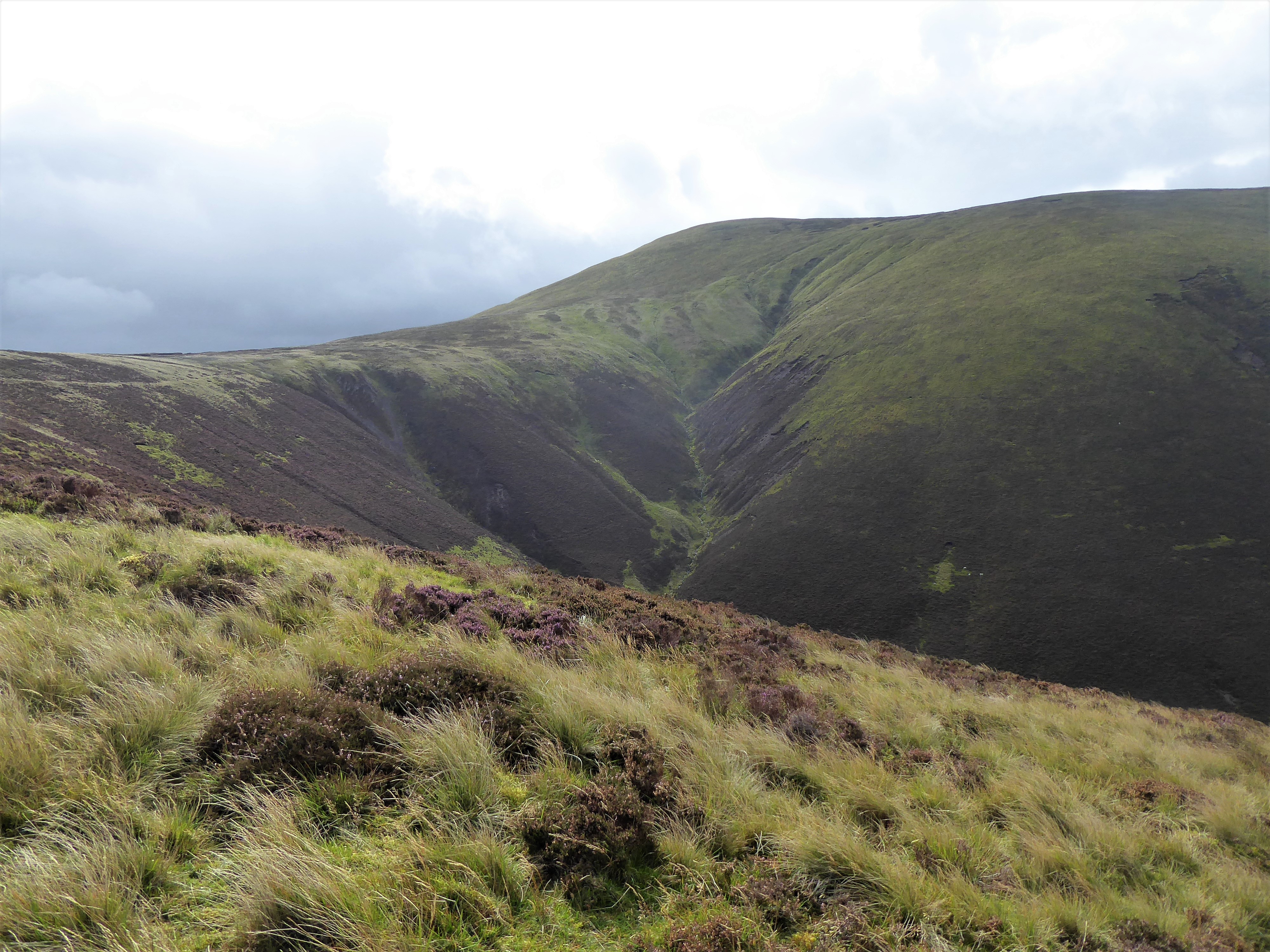
Meall Garbh from Greigh's broken cairn. Ben Lawers on the left and the peak of An Stuc in the middle.

Then there is a 2km descent of about 200 metres, terrain now extremely boggy, very muddy boots. There is a fence of sorts to follow up to Meall Garbh a fine bad weather aid. 

A closer view of the slopes of Meall Garbh. More walkers to overtake whats going on!

The ascent lasted about 1k but is steep, almost 300m of ascent to reach today's highest point, exactly the same height as An Stuc. About half way up a full on storm arrived, heavy rain, very high gusting winds and the temperature dropped considerably. 3 hours from the start which I was happy with. 

Yet another top with no views of An Stuc, it has been a bogey weather hill for me.

However, no view so no hanging about and no An Stuc, I headed downhill to retrace my steps even though it meant another ascent of Meall Greigh. It counts as a Munro from this side but as I bagged it earlier in the day, no new tick. 

The route heading back to Meall Greigh.

At least the gradient is kinder if not the bog hopping, gloopy stuff. I pass the kids, still cheerful but not even on number two, I cannot see them doing six.

Looking back the storm has gone and everyone now ascending will have the views that I did not, no envy here. Back on top of Greigh and excellent views over Loch Tay, Glen Lyon and on to deepest Perthshire.

Back at Meall Greigh the eastern view over Loch Tay and Perthshire. 

Now simply retracing my out route, at times I felt as if I was practically running on the descent but still care required great heel slip conditions. Back on the tarmac and tendon now fully sore again, weird. There are many ruined shielings around, a reminder that this was a well populated area mainly flax spinning. 

The swallows grouped on the wires made me smile and a bit sad, no doubt on there way to warmer climes, lucky them.

Finally a look at the carvers impressive collection of horns waiting to be transformed into walking pole handles etc.

An excellent walk in mainly dry conditions. The ascent was up there with my aborted trip in terms of distance and ascent but I was doing this at my own pace which made a difference. 

Now the bagging map moves on with another couple of Munro weeks and then I need to concentrate on the other categories.

Wildlife: Raven; Crow; Meadow Pipit; Wheatear; Swallow.

Ascent: 1367m 

Distance: 16.9km 

Time: 5.45