Wednesday 28 August 2019

Millfore a Galloway hill ramble

Hill:Millfore
Category: Graham/Donald
Height: 656m

Another midweek walk with the Ayr OIR high walking group. Weather has been good to us recently and the forecast was good for our visit to the Galloway hills.
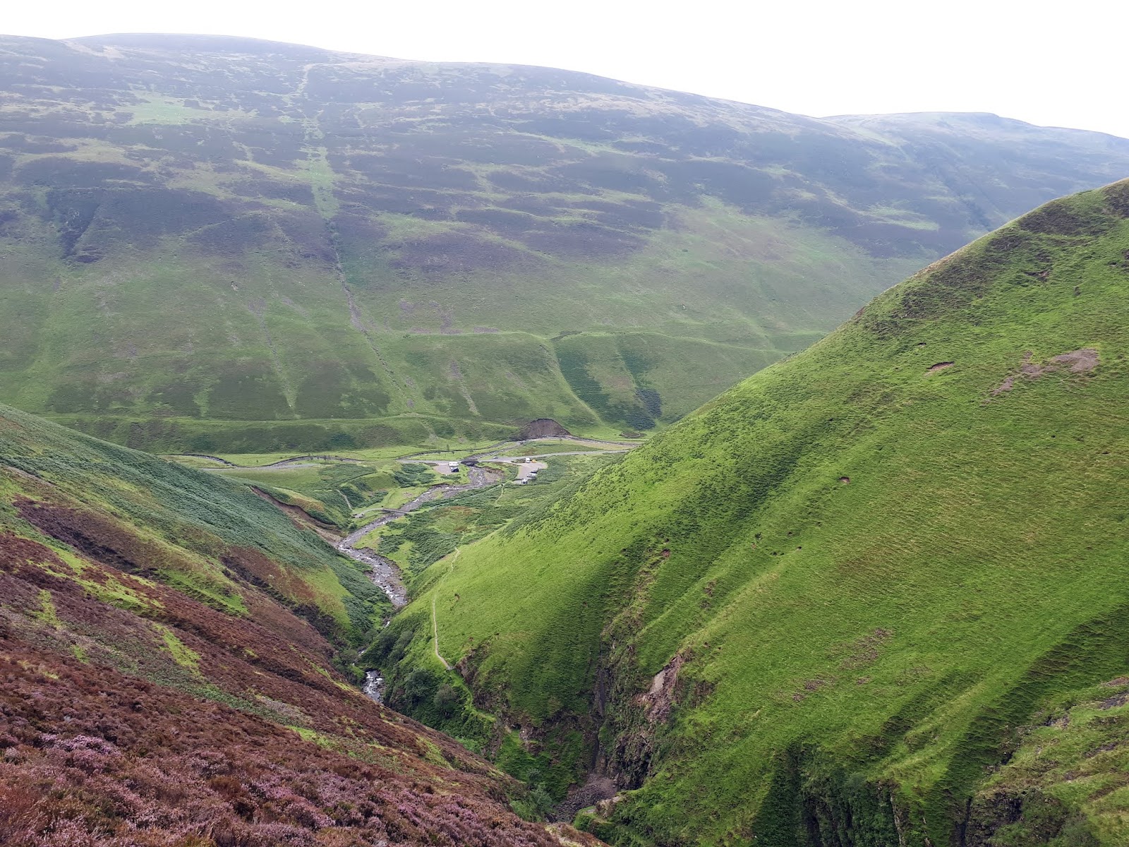
Galloway's Grey Mare Tail
This walk began at the Grey Mare’s Tail waterfall which although a nice enough little water fall is not a patch on its namesake that I visited on my last blog.
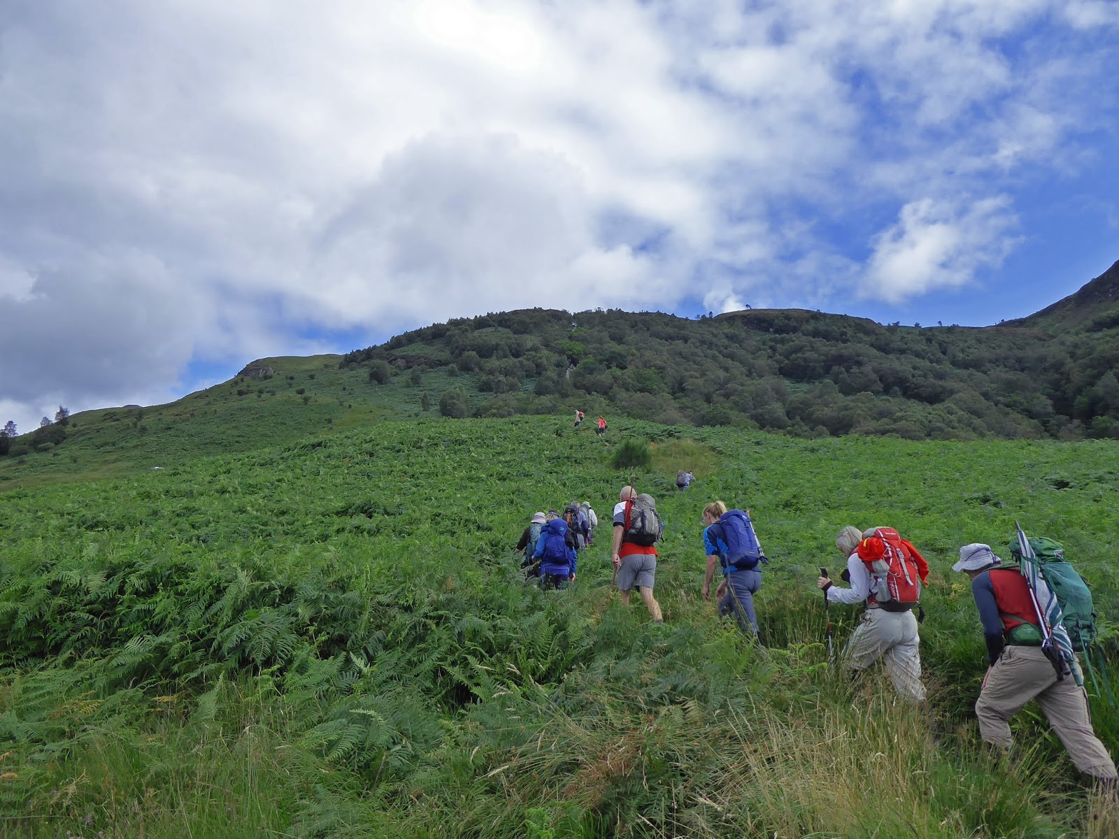
The walk follows the burn up and through some very tall bracken, perfect tick country. 
Stone art
Before long we hit some old ruins, a derelict sheep pen apparently, where there were interesting facial carvings in the stonework, good for a smile.
More stone art
We then joined the forest road to the black Loch where we met the walk as per Walkhighlands description. The impressive pointed small brick chimney called ‘The Eye’ by Colin Rose built in 1977 as part of the ‘Art in the Galloway Forest’ project.
Grassy slopes to Millfore
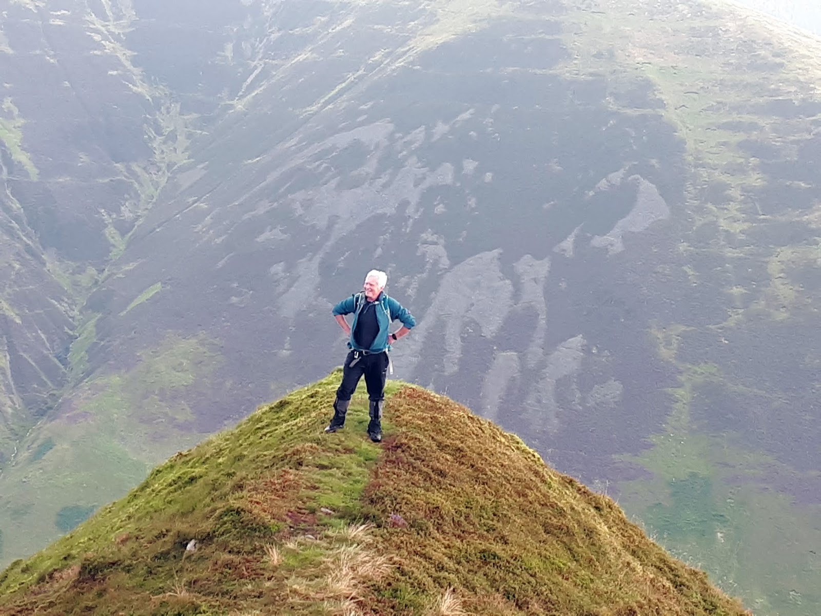
At some point we spotted a faint quad bike track heading up and down the rough ground to Millfore. As always a few false tops before we reach the top and spot two of the many cairns on this walk. 
Millfore
Millfore also has a trig a very busy top.
It is a cool wind that is blowing so we shelter on the lee side for lunch. Great views over Loch Dee, Curlywee and Lamachan Hill. 
Curling loch
There is a super view of the White Lochan of Drigmorn which was used for curling in the 19th century. We did not go over to it but apparently the stone structure beside it was built by soldiers during the Crimean War, proper history indeed.
Ridge to Drinmore
After lunch we walked the short ridge to Drigmorn Hill, with Red Gairy on our right,  where during the 2nd World War an American Liberator bomber crashed killing all 8 of the crew. But no sign of the crash site on our walk.
All that was left was our descent across typical Dumfries and Galloway tussocks, wet, rocky and at times boggy descent to the edge of the woods. Over a fence and a faint track along the edge of the trees to arrive at the outgoing forest road and then same route back to the car park. 
Another good walk in good company, the time flew by.

Wildlife: Peacock butterfly; Raven; Meadow pipit; Wheatear
Time: 4.42
Ascent: 651m
Distance: 14.4k

Monday 26 August 2019

An impressive White Coomb circuit

Hill: White Coomb; Lochcraig Head, Molls Cleugh Dodd
Category: Corbett/Donald x3 (WC counts as both)
Height: 751m ascent?

An early morning start with a B & B brekkie in the tummy. A few overnight campervans but obviously too early for other walkers, a huge contrast with my return to the parking area.
Grey Mares Tail
With the recent rains the falls of The Grey Mare’s Tail were in full flow, a superb sight and sound as huge amounts of water crash down. They are rightly in the top ten waterfalls to visit in Scotland. A good excuse to stop and take a breather and take it all in, excellent views back down the ravine. You can appreciate how there have been fatalities here particularly in winter. A peregrine flies over so fast it soon disappears out of sight as it goes after unseen prey.
Tail burn looks ok from here but not when close up
As I amble alongside the Tail burn I am looking for opportunities to cross on my way back. Not surprisingly the water is high and fast, few stone jumping opportunities, I mark one spot.
Loch Skeen with Lochcraig Hill on right
A couple are wild swimming in Loch Skeen, far too cold for me to try that but they say it is good for you. Lochcraig Head’s crags look mighty impressive and steep, from here.
I should have left this boggy track earlier and cut across to the dyke. As it was I had a long arduous plod through deep heather, peat hags and moss water traps all with clegs buzzing around my face. How I was not bitten today I do not know, they have liked me well enough in the past.
I finally reach the dyke and follow the worn wet path slowly up the hill. Legs are feeling tired today and it is harder going but I have had 4 big walks this week, must getting too old for this.
A pair of kestrels appear, twisting and turning with each other before static hovering, eyes on the ground, but no luck, away they spin. Not sure how large their territory is but conceivably the same pair as yesterday at Whitehope Heights.
Loch from Lochcraig Hill, White Coomb on right
Finally I reach the flat plain and go to the large cairn overlooking the loch, a nice but hazy view. The true summit is over the other side of the dyke, not photogenic.
I thought I was going to get a breather but nope a descent into Talla Nick and backup the other side. It was boggy down there, I tried walking the dyke but too dangerous, stuck to the mud.
More raptor diversions to take a breather. There were more wheatears in these hills over the last two days than I can remember seeing. Every few steps birds flew out of the stones. A sparrow hawk was well aware of this and patrolled up and down the dyke. Most birds were out and back in again before the hawk could strike, I am sure it has its turn. I wonder if the wheatears are migrating from the north and stopping here in the good weather? 
Molls Cleugh Dodd, small cairn straight ahead on horizon
At the top I knew there was an optional diversion to take in the Donald Molls Cleugh Dodd. Looking at the map last night that I saw that it was a fairly level walk so despite the protesting legs I took it in. Another case of a larger cairn and a smaller one. Take them both in again just in case. Nice views of many rolling hills.
Now high level grassy walk to White Coomb
Thirty minutes later back on track and I could see White Coomb over to my right, no more big drops just a solid slowly ascending high walk, following the fence line. Taking it easy and enjoying the views.
Before long I was following a track that moved away from the fence. I was just strolling along before instinct said this was not right. A quick check and now a drudge over the moor to a stile in the fence. It was surprising how much more effort was required in the longer grass.
White Coomb cairn
Over the stile and almost immediately there is the top of White Coomb. A good all round short view, too much haze to see far into the distance, that has not been much of an obstacle this year. Clegs are still buzzing around I wish I had one of those bush hats with the dangly bits.
Follow the dyke back to the Tail burn
I followed the obvious track down, sometimes very steeply. I knew from my earlier look at the burn there was no point in following the dyke to the normal crossing spot. From up here the track to the loch was mobbed, had a coach load of ramblers arrived for a day out? 
Once down a good bit I left the track and took a line through the heather and moss heading towards the mouth of the loch. There are fords marked on the map but none were crossable today. A couple of maybe attempts but the wet rocks were so slippery that I could not get a grip for the final jump. An audience was now gathering on the other side, I was today’s entertainment!!
Finally one a few spots where dry tips of rocks protruded, walking poles a must for balance for the final leap, made it. 
Looked at my watch exactly 4 hours, wow after the initial struggles I made very good time considering I also took the detour.
Looking down to the car park
It was very warm so now I took my time amidst the tourists back down the trail to the car park. 
At the bottom I put my cap in the burn and poured the cold water over my head. Relief and the highlight of the walk.
A very enjoyable walk and glad I did it early in the day.

Wildlife: Scotch Argus; Peacock butterfly; Burnett moth; Peregrine; Kestrel; Sparrowhawk; Meadow pipit; Wheatear
Time: 4.38
Ascent: 835m
Distance: 15.1km

Roller coaster hill walk to Whitehope Heights

Hill: Whitehope Heights
Category: Donald
Height: 
Last night's forecast was for a return of summer so I made plans to do some more Moffat hills.
View from parking area
On the drive down there were more grey than blue skies, not good news. When I got out of the car at the walk start the temperature reading was 19 deg, it felt nothing like that in the chilly breeze. My target today was the Donald, Whitehope Heights. From this viewpoint I suspect that the top hidden in the clouds was my target and indeed that proved the case. 
Start of walk clouds already rolling in
As soon as I started I was squelching and splashing through sodden marshy grass and this was the case for the whole walk. I had hoped it would be drier up top but not too be.
The early stages were enjoyable but it is a rollercoaster of a hill walk, up and down constantly. The Devil's Beeftub is to your side but from this angle there are no views of it, leave that for the descent. For about half the walk you are following the Annandale Way so there are some markers around if you need them. 
Green, green and more green
Surprised to find at the top of Annandale hill a trig and a seat presumably to enjoy the views back to Moffat, not great today. A pair of kestrels hover, I wonder if it is a parent teaching junior to hunt?
Flapping and calling behind me breaks the silence, an unkindness of ravens appear, over 20 of them. Maybe they think I will be lunch. A deer fence appears out of the gloom on my right but no beasties seen today.
Through the gate keep following the fence into the clouds
Green is the colour, grassy hills but no flora or fauna to brighten up the landscape. But if in doubt just follow the fence.
Finally after a few ups and downs I reach the cairn where the Way heads back down the valley but my route continues up the wet grassy slopes.
I hit the cloudline at 550m and it is grey and gloomy from now on. In the clouds it was a full on weather depression, the wind was gusting strong and cold, but at least it didn’t rain.
The gate saved a climb
The deer fence has been coming and going in the murk but eventually I reach the gate in the deer fence and shortly the cairn is reached, 1 hour 25.
Not much too see from the top
I was in no hurry but no point in hanging around here. There is the option of going on to Hart Fell but why, this is not going to lift. 
What is about to emerge from the black cocoon?
On the way down I spot this black cocoon, I wonder what is inside it?
Returned by the same route except I took a different route up Great Hill to get a good view of the Devil's Beeftub. The cloud was now down to these lower levels so a wet tramp back to the car. 
I wonder what happened to that summer weather? 

Wildlife: Peacock butterfly, Wheatear, Kestrel, Raven, Meadow pipit
Time: 2.51
Ascent: ft (632m)
Distance: m (10.1km)

Wednesday 21 August 2019

Magnificent Three Beinns horseshoe on Arran

Hill/Walk: Three Beinns, Arran
Category: Corbett
Height: 
Yesterday was a grand day on Arran where we tackled the Three Beinns of Beinn a Chliabhian, Beinn Tarsuinn (The Corbett) and Ben Nuis in an anti-clockwise circuit. 
Crossing the very wet and very boggy grass for an hour. The circuit on the left.
I have posted a walk report these hills previously so I will keep this short and let the magnificent beauty of the island take centre stage. On days last this it is a magnificent experience that few in the Central belt will share, their loss.
A slightly different route in that we took the bus up the String Road saving the long trek in through Glen Rosa.
Stile for deer fence but no help for the burn crossing, nobody fell in.
Although we did have to cross the burn twice, thankfully it was not running too high.
Apart from the amazing scenery the highlight of the day was on the descent where I came across a black adder, a first for me. It was sunning itself on a rock, almost stood on it as foliage covered the track. I started to get my camera out when it darted its head forward, forked tongue came out in attack mode then immediately slipped away into the long grass, quite superb.
An excellent walk in great weather which provided spectacular views. The company in excellent form as well.
Beinn a' Chliabhan hill number 1

Our target on left of ridge, Pagoda ridge and A'Chir on the right

Cir Mhor in centre, The Saddle and North Goatfell to the right

Beinn Tarsuinn ahead, the knoll on right has to be negotiated

Hands on needed on Consolation Tor to get to Corbett top

The full Goatfell ridge through the gap at The Old Man of Tarsuinn

Great rock formations up here, further along the view into Glen Rosa, Holy Isle in background.

The descent down Coire na Cuiseig

Cooling off
Wildlife: Black Adder, Raven, Stonechat, Meadow pipit, Scotch Argus, Peacock, Painted Lady,
Time: 6.31
Ascent: 2888ft 1058(m)
Distance: 11.69m 18.7(km)

Sunday 18 August 2019

A stunning horseshoe circuit, Hart Fell.

Hill: Hart Fell, Swatte Fell, Under Saddle Yoke.
Category: Corbett/Donald x2
Height: n/a
Weather forecast suggested this area might be the best place in Scotland to avoid torrential rain and thunderstorms, would it be accurate.
Well, that was one cracking walk but what a toughie, particularly the initial climb to Swatte Fell. 
Start ascend the left side Hang Gill gulley
We decided to walk anti clockwise to head up the side of the ravine. Boy did that get the heart rate up. I foolishly decided to leave my walking polls in the car as not been using them much recently. But this was definitely a slope for them. Walkhighlands says ‘from here the next stage of the ascent becomes extremely steep‘ no exaggeration!! The bracken was fairly high but the main challenge was wet slippery morning dew grass on very steep gradients meant I was grabbing all sorts to haul myself up, including the fence wire, wow what a start. Heart racing, jelly legs and we have a long way to go.
Sun briefly shines down below on Black Hope burn
The views were superb particularly when the sun briefly illuminated the slightly grey skies.
Black Craig, don't step back 350m straight down
 There is a brief reprieve as we follow the fence before there is an unrelenting climb towards Black Craig. A pair of red kites glide past. Big drops down to the right with excellent views across the glen to our descent and final hill Under Saddle Yoke.
Another brief respite as the terrain flattens going past the small cairn, thought at first this was the Donald top but no, slightly higher ground ahead, a fence, the top, Swatte Fell seems to be unmarked but GPS said we were there, did we miss something? An unrelenting ascent, no doubt.
Upper Coomb Craig with Upper Saddle yoke behind
We headed along the wet ground to Falcon Craig. I assume there are falcons but none spotted. Down to the col at Hass o' the Red Roads, I love the border names on the hills around here and across Galloway.
Falcon Craig
Once again the world goes upwards, another steep climb before flattening out and I was delighted and relieved to recognise the trig of the Corbett Hart Fell. I needed my lunch. Last time I was here I came up the other side via Arthurs Seat, not the famous one.
Cool spot for lunch Hart Fell trig
No rain for us so far but we could see showers around as we took in the excellent all round views. Lunch was relatively brief as the wind went through the gears to very strong and it was decidedly cooler.
Picturesque rolling border hills
As always in the border hills you tend to follow the fenceline as we did for a while before descending through the now pathless grassy slopes and peat hags.
Upper Saddle Yoke ahead
The final Donald can be seen but there is an unwelcome descent through plenty of rough, tussocky, boggy ground in between. 
Descent from Hart Fell
The ascent to Under Saddle Yoke is a plod through mostly pathless ground, follow the sheep trails when you can, just keep heading up. Take a breather and look back and down to the glen, the views are excellent. A fence needs to be negotiated, it is electrified but wasn’t on, if it was there is a stile to assist. Another short climb beckons, the last, not quite!
Twin tops Under and Saddle Yoke
From the top of Under Saddle Yoke there is one more descent and re-ascent along an excellent narrow, arete-like grassy ridge leading to the summit of Saddle Yoke. As Walkhighlands says ‘This fine ridge is quite unlike most hillwalking in the south of Scotland‘.
Narrow ridge
It is a good place to spend a few minutes taking in the views as you get a panoramic view of almost all of today’s circuit. It looks pretty dammed fine from here. The Jelly Babies very welcome as well.
The winds halted our fun, once again very strong and gusty, time to make the excellent looking descent. I would not want to be on exposed places in these gusts.
Fine descent ridge
Followed the track, grass not wet but smooth and shiny so a few heel slips occurred, care was needed, no accidents now please, almost home.
Our cars can now be seen and we veer off the track to the right through more slippery grass to meet the barbed wire fence, no stile this time and then the track back to the cars. Stop here and look back up the glen, it is a superb view.
A tough walk done at a fast pace. Good company and great views. No rain what's not to like.

Wildlife: Red Kite, Buzzard, Meadow Pipit, Carrion Crow.
Time: 4.26
Ascent: 3126ft 
Distance: 8.49m 

Friday 16 August 2019

Nice to get out for a walk, Ben Lomond via Ptarmigan ridge

Hill: Ben Lomond
Category: Munro
Height: 974m
A day out with the Ayr OIR and delighted to get a proper hill walk, it feels like ages.
The weather forecast predicted a generally fine day with occasional showers.
Our plan was to ascend via the Ptarmigan ridge and come back the tourist route.
Looking north from the start
The car park was very busy for a midweek, mainly foreign voices, probably looking for their trophy hill for their trip. Many that we saw on the day woefully under equipped for a serious hill walk.
Ascending the bracken slopes
We started by zig zagging up the bracken encroaching path, single file only, a good pace maintained, sweating already.
Stopped for a short break mainly to put on waterproofs, yes we had met that occasional shower, more like a downpour. Some young kids came bounding past us further deflating the group egos.
The Cobbler

Great views across to The Cobbler and its companion hills, thankfully the rain has cleared so we can see them.
Interesting landscape
The showers were off and now blue sky above as we approached the final ascent of Ptarmigan ridge. 
Ptarmigan ridge climb ahead
In the winter this is a totally different proposition, a dangerous area, but today just hard graft.
I said it was busy!!
However the winds increased and it was bloody cold, many extra layers and gloves donned, yip still summer.
Relieved to reach the top, bio rhythms out of sync today this was harder than it should have been.
Don't see a brolly on top of a Munro every day
A short food break before making the long trail down the tourist path. There were many still ascending. It is an easy descent but it is also a bit of a drudge, good views though.
Long descent but take in the views
Looking back the cloud had covered the top, yet again, but we were shedding clothes, that type of day.
As always a good hill, excellent views with this air clarity, good company and humour, a fine day out.

Wildlife: As expected on a hill with so many people only the ravens!!
Time: 4.54
Ascent: 3172ft 
Distance: 7.85m