Thursday 15 October 2015

Allermuir Hill...A Pentlands ramble

The way to Capelaw hill and beyond Allermuir
What a day, bright blue skies with a crispness in the air I was heartened as I had allocated today for a tramp around the Pentland Hills.
My chosen destination was Allermuir hill, the only decision to be made was how to get there? There are more than a few options to start from: Bonaly; Colinton; Currie; Harlaw; Dreghorn & Flotterstone and more.
As it was a fine day and I wanted a good stretch of the legs I decided to start from Currie. This route meant that I would be taking in at least 4 individual hill tops and possibly more.
From the village take the road upwards past Currie Kirk and when you reach the right hand bend for Harlaw car park go through the gate and head up the dirt track towards the hills.
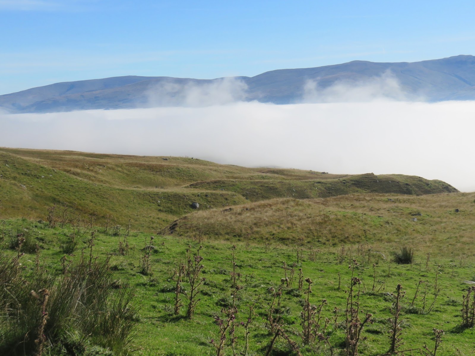
Looking back from Harbour hill
Despite the relatively early hour a female mountain biker descended past me with a cheery hello. Once you break out into the open country there are great views of the hills as you walk towards the Maiden's Cleugh. I believe that Cleugh means ravine or steep valley and the latter is a possibility here.
But today I don't descend into the Cleugh, at the gate I turn left and climb up Harbour hill which is documented in a previous blog. From the top the views are already impressive and I take a few minutes to take it all in.
Capelaw, Allermuir then Caerketton from Harbour hill
A descent takes you into Phantom's Cleugh, no phantoms this morning just sheep. A steep climb gets you to the top of Capelaw Hill where the views of Edinburgh & Fife are magnificent. These are only spoilt by the huge plume of smoke/steam belching out from Mossmorran petro-chemical plant. The huge plume looks more like a bomb exploding upwards into the clear sky, West Lomond hill stands to it's right as we look. There is a rather unusual marker post on top of Capelaw although I'm not sure what it is meant to represent. So far I have the hills all to myself. A few self timer photos are attempted but not all successful.
Mossmorran plume of what?
Back down the other side with my main objective, Allermuir Hill, now in my sights. This walk certainly takes you up and down each hill so I am getting my exercise. Another steep pull and the top is reached. Time to enjoy the wonderful views and have a refreshment. Some more walkers arrive from the other direction so a couple of conversations take place and one kindly offers to take my picture. Thanks. The summit has a trig point plus a hill marker so you can spend some time trying to identify them although the haze rules out the more distant hills.
Looking back south over Scald Law ridge
Time to move on to my final hill of this section, Caerketton Hill. Another up and down but this time I spot the dreaded fresh cowpat. Now where are they hiding? On the ascent I spot about half a dozen in the thick heather and ferns to my left but they do not look interested in me so up to the summit which has a small cairn. Again superb views, the views to the south coast, Berwick area, have fully opened up.

On top of Allermuir
I decide to walk along to the final high point above the Hillend dry ski slope. A group of 8 guys appear, not exactly dressed for the outdoors and some more fatigued than others. It turns out they are Danish holidaymakers, I have a chat with the English speakers and they ask about the hills. I show them my map and they agree to try for Allermuir.
Looking towards Caerketton hill
I originally was going to descend at this point and get a bus back but I have made good time and decide that it is too early to head home. I am going to add Castlelaw Hill to today's outing but to get there I have to retrace my steps and re-climb Allermuir Hill. The Danes tag along and 4 of them make good progress whilst the other 4 lag a bit. At the top it's my turn to become the photographer for the Danes holiday snaps.
I head down the grassy slopes then follow the military road up to Castlelaw. It is really the only way up without going through rough moorland pasture. If the red lights are on the military are active but not today. The top is marked by the electronic lights but the views back over Glencorse reservoir valley and the Scald Law chain are excellent.
Glencorse reservoir from Castlelaw
I tramp down and kind of lose my way as the ground becomes very steep, stony and slippery. Thank goodness I took both walking poles with me today, I needed their anchor points.
Finally I get down to Glencorse reservoir and walk the Maiden's Cleugh pass back to Currie.
All in all just over 5 hours of tramping around the Pentlands, excellent views and weather it doesn't get much better than this.
As always I am now ready for that pint or two, It has been fully earned.

Thursday 8 October 2015

Tinto

Tinto from carpark
Now that the fishing season is effectively over it is time to get out and about focusing on walking again.
My walking partner has suffered badly with planter facitisis but felt that he was recovering and wanted to give a reasonable hill a go. I have been struck with this three times over the last 10 years and the last was so severe it effectively finished my jogging career and took almost a year to heal. The treatment is effectively rest, then stretching, then slow introduction to exercise, but it is notoriously difficult to cure.

Neither of us had walked Tinto for over 10 years so it would be nice refresher. Tinto stands in splendid isolation in the Southern Uplands close to Lanark and Biggar and is a prominent landmark for traffic on the M74. It stands at 707 metres but you are starting from an elevated spot so actual height climbed is nearer 500 metres. The open summit gives some great views in all directions and with today's weather forecast being good we were optimistic. It is said to be the highest hill in central Scotland but that depends on your definition of central.
We were joined by his pointer and a lab that needed to lose a bit of weight so 4 to the party on the hill.
Lee & dogs on scree path
There are 2 options and we decided to take the standard trail from Thankerton. The other route from Wiston is longer but I thought that it might take us over farming fields and livestock, not recommended with the dogs.
There is a good car park at Thankerton and the hill is so popular that the route is a distinct scar on the hillside all the way to the summit.
The lower slopes are all patchwork heather and great grouse country. About half way up it splits into a more reddish rock strata. We thought the dogs would spook a few birds but we only saw two and that was right at the end of the walk.
Half way up looking northwest
It is an easy climb and can be achieved by anyone with moderate fitness, Some of the people we passed today would be surprised by the chill factor at the top and some clothing was certainly not adequate. So, the usual provisos, it is a mountain and weather can change very quickly. There are some scree patches as you gain height but mostly you are walking on solid ground, so for us good time was made on the ascent. Looking straight ahead the view is not great, just the hill, so it is worth stopping and looking back to take in the impressive vista. We had a few walkers in front and met 2 groups going down. More impressively 3 different hill runners came past, those were the days but certainly nowhere fit enough for that now, mighty jealous of them.

Dark clouds started to gather over the summit and a fresh wind picked up, jacket back on. We reached the massive cairn after 1 hour 10 minutes. This is a massive prehistoric bronze age cairn now well hidden with many thousands of boulders. The view indicator is detailed so if it is quiet you can take your time, hog the indicator and pick out a lot of the hills. Sadly wind turbines spoil a lot of the views, what a mess some of our countryside has become. We can see as far as the greater Glasgow conurbation to the north, the river Clyde below and the M74 traffic. The official trig marker is a short way off from the cairn.
A couple of walkers approach the summit, the cloud over the summit
The wind was freshening so we had a quick bite to eat then slowly went back down. My partners foot had far from healed so he was in a fair bit of pain, slowly down the hill we walked. A pair of kestrels were spotted, lovely, all to rare now. A pair of ravens glided over the heather trying to spook a small bird and a single buzzard. That was all for the birds today apart from the grouse later on. Going slowly was not an issue, magnificent views to savour in a blue autumn sky.
On the way down looking south
Looking back the summit cloud was now very dark, possibly rain and it looked cold up there.
Overall 2 and a half hours for the round trip. An easy hill with super views, well worth it but I don't think my partner will be walking again for a while, recovery is not that quick.

Wednesday 7 October 2015

Brown Carrick Hill....The hill of cattle!!

I wanted to walk a small hill today and for it to be close to home. Brown Carrick Hill was on my to-do list for a winter walk but today would do for my first climb of it. At just under 300 metres it is classed as a Marilyn. Perfect for today I reckoned a maximum of an hour up and the same back depending how much plodding about I did at the top.

There are some cheat versions of this walk including driving up the Carrick hills road and parking beside the masts but what's the point of trivial ticking a list and not enjoying a walk?
As such my intention was to begin the walk sea level from Dunure harbour but roadworks were going on today and there is very limited other parking so I drove back up the hill and parked beside Fisherton primary. I have walked up from the harbour before and you don't miss anything as it is tarmac all the way to the school. The attraction of parking down at the harbour is a longer walk and there is a cafe plus pub/restaurant at the harbour for refreshments when you return.
The path through the cow field I came up the one on the right
The walk starts with the hill crossing to Maybole. The route goes up past the primary school and up towards a farm, the route then turns left heading upwards through fields. I can see the track but there are a herd of cows in the field, most of them lying on the track I had to walk. Readers will know I have had previous with cattle, not a good experience, and now give them a very wide detour. The field next to it also contained cattle but they were at the far side so over that gate I went and followed the fence up to the top of the field. Trying to get back on track was fun as the only route to the gate was a bog of mud where the cattle had congregated. The other option to climb the fence further down, barbed wire and a plain wire, was it electrified? A touch revealed it was electrified and the current was on. So through the mud I went, goo up to my ankles then climbed over the rather old and broken wooden gate.
Typical moorland, private run down fishing water on the left
A stile indicated a track which I followed as it led up onto open moorland towards a wood. There were signs of recent cattle droppings and the feeding stance was full of hay so a very wary eye was kept, the ground was good camouflage for cattle. Although I spotted a few more recent droppings I made the forest cover without seeing any cows.
Nice view of South Ayrshire coast
Now a poser, the stile indicated the track would go to the right along the forest edge (Maybole) but I reckoned I wanted to go through to the other side. I had not brought a map as I was so close to home and no phone signal so no Google maps to check either. Luckily the tree planting was not deep and when I got through these the hills looked more like where I wanted to be. 
The terrain was still moorland but not bad walking. A few sheep droppings, fine, but some recent cow pats meant full alert again. I headed for the highest point and from the top I could see the trig. Another five minutes and I was there. Roughly about 45 minutes after leaving the car.
Trig in the distance
Although the wind was blowing a hoolie the views were good particularly over the Ayrshire coast. The haze meant Arran was not as clear as I hoped, better for eyesight than photos and no sign of Northern Ireland. In the other direction the Ayrshire countryside around Maybole, Straiton etc stood out but again hazy. A few attempts at getting a trig selfie using the timer eventually resulted in this pathetic effort. The problem was there was nowhere to balance the camera except my rucksack, thus this pathetic effort.

I decided to walk along the ridge to the masts still wary as fresh cow pats with flies buzzing on them were around. When there you go, I almost walked right into them. Over a hillock a herd of hill cattle all chewing the cud and the first one looking my way had huge horns like a steer you see in cowboy films. 
No way past that lot so I went back to the trig and could see no other obvious route down so I decided to just descend the same way I came up. 
All was fine until I reached the boggy fence and the cattle on one side were almost all on the path I had to descend. Even worse the cattle in the other field were now spread right across the field with a couple in my direct line. I decided I would just have to go for it so started off down the hill. At that point a bull appeared and went right to the spot I would have to cross and started bellowing to the cattle in the next field, that field was my only other option. As I pondered this dilemma a dog walker appeared along the track at the bottom. He had the dog on the lead but the heifers were now well worked up running alongside the fence leaping up and down. No way I was going to risk going through them in that excited state.
I decided to walk a parallel course along the fence at the top. The moorland here contained ferns and bushes ideal places for cattle to be, fresh pats did not help. I got so far along when I came across an empty field to my left and the one further down likewise, my escape route?
Across the first field fine, over the fence and into the second. It looked empty but fresh cowpats still meant red alert but I reached the next fence okay. There was a small sub station about 100 yards away which must mean a track. Down I went and as I went past the sub station 3 bullocks were standing in the way at a feeding station. Fifty yards from safety!! One was spooked by me and jumped which made the other two do the same but in the process they battered their heads off the metal top of the feeding station, now well excited all 3 ran away to their peers. Let's get out of hear fast. As I made my last turn a full sized black female cow stood there looking right at me, then looked at the three scampering away, then back to me, bollocks or a lot worse was uttered. No choice I marched on and was relieved to clamber over the fence onto the path with blackie still staring.
So a 2 hour adventure after all. I was going to takes Mrs B another day and I will but we will wait until winter and the cows have all retired from the fields to their snug barns.

Sunday 4 October 2015

Cumbrae revisited.....Porpoises

Wild flowers on Cumbrae looking over to Largs
It's been a few months since I was last over to Cumbrae and a visit was long overdue. The only choice today was whether to walk or cycle. I decided a longer more leisurely day was what was wanted so walking it was to be.
The weather was excellent today and as always the short ferry crossing from Largs gets the juices going. Boarding a Calmac ferry always feels like I'm going on holiday and I become a wee kid again.
Cumbrae history
A change of routine is preferred today so my walk will circuit the island in a clockwise direction. My preference has always been anti clockwise simply because you get the feeling of remoteness and isolation almost straight away. Today's route follows the 'busier' 4 mile section from the ferry to Millport although it is only really busy for a couple of minutes at a time as the cars from each ferry scoot past.
What a lovely feeling to have the sun shining, so much more enjoyable. The cyclists are also out in force, the bike hire shops in Millport will be happy today. This side of the island gives you views across to Largs, the marina, Hunterston power station and the hills behind them. There is always some activity on the water to have a look at.
Unusually calm waters Arran beyond
The main interest for me is on the shore line looking for the birds on the rocky shores. The island has a lot more activity during the colder months but still enough around today. A flock of curlews fly across the water. Another flock of of peewits land in a nearby field. A pair of buzzards rise from the trees and circle on a thermal. A grey heron is spooked as I walk past calling noisily as it flies away. Terns and most gull species are spotted.
Lion rock
As always 'lion rock' is worth a minute or two to reflect on the geology of the island that created these formations.
This brings me to the museum/aquarium. Last year it was threatened with closure but new buildings have been constructed since my last visit so presumably all is now well. Also I spend a few minutes reading the plaque about an Antarctic expedition from over a century ago, always interesting.
There are a few guys sea fishing from the rocks as I make my way around the headland entering Millport. The bay full of boats and the hills of Arran in the background just stunning.
There is one routine that I don't change and as always I head to the butchers and get a hot Cumbrae pasty and sit on the front to enjoy eating it, not healthy but superb. After that the next shop gets a visit for the healthy stuff an orange and a bottle of water.
It is good to see the place busy but our school holidays end in a couple of days so it will be left to the English holidaymakers of whom there are quite a few voices heard today.
Millport
After a walk along the front up the hill of golf road to get away from the main island road for a bit. This shortens the walk by a couple of miles but the views from up here are a highlight of the walk. As I cross the isolated hill ground I suddenly spy some coos in the grass just ahead. One rises but thankfully they take no further interest. Just as well as there is nowhere to go and no trees to climb.
Back on the main road and the only cafe on this side of the island is popular. I think I have earned an ice cream but on the board I see a Solero advertised, an iced orange cream lolly, when was the last time I had one of these? A few years probably but it tasted just as good as I remembered.
Porpoise bay
As I walked further on I was looking at the flat calm glassy waters in a lovely isolated bay when I noticed a very large circle in the water making me wonder what could have caused that. I soon got my answer as a pair of porpoise, close together, arched their backs out of the water as they rose in unison to breath, quickly disappearing under the water again. So close to the shore, so spectacular, nature at its best. I saw them rise another 4 times before they went under submerged for good. It is not the 1st time that I have seen porpoise in these waters but this was the best sighting by far.

Suitably chuffed I headed back to the ferry having had a really good glad to be alive day.

Meall nam Maigheach

The burn beside parking area looking towards Glen Lyon
The weather has been absolutely glorious this week in Perthshire, clear blue skies and heat, what an Indian summer. 
With the great weather still forecast for a few more days I wanted to do a decent hill walk, Carn Liath was suggested, but with Mrs B's fitness we decided it had to be an easier hill. After consulting the Corbett's guidebook I found what I thought was perfect, Meall nam Maigheach 779m (hill of the hare), which sits in the range between Loch Tay & Glen Lyon. The climb should be just over an hour for fit people, principally due to it's very high starting point which means you only climb about 300 metres or so, add on another half hour for Mrs B's pace and it still fitted perfectly for our needs. 
Loch Tay is below the fog
Our drive from Pitlochry started with a heavy mist and by the time we got to Loch Tay it was a full on pea-souper. As we drove along towards the Ben Lawers cut off it was getting even worse, all traffic practically crawling along, what chance a walk today we thought. We were the only car turning here and driving up the very twisty single track, waiting for something to come down out of the fog, head on, was interesting to say the least. And then, wow, we broke the clouds to be greeted by the vivid blue sky we had expected. The drive was now more comfortable as at least you could see if the road ahead was clear, at least until the next blind bend. A few stops to take snaps of the foggy background below and it wasn't long until we reached the parking spot at the start of the walk.
The boggy tract to be crossed with Maigheach beyond
I read a few descriptions of the walk on the internet and knew that it would not be the most exciting I had ever climbed. The traverse from Glen Lyon appears to be the most interesting route but no way Mrs B could do that one.
The guide says to cross the tussocky grass/heather and head for the stone dyke wall which leads all the way almost to the cairn. Certainly helpful if you are doing this one on a poor visibility day. There is no obvious path across this section so we just picked a line and head on. At times the walking was quite boggy, surprising really considering how dry it has been. To avoid the most boggy areas it becomes a zig zag route towards the dyke. The amount of insects coming off the heather as we trod through was incredible. What were the odds on me getting through the walk without my bare legs being bitten?
Looking down the dyke
Once we reached the dyke was a straightforward guide right up the hill so you cannot go wrong. It is not the most outstanding walk but if you stop regularly and look around the views are very good. Up ahead we spotted a pair of red deer hinds looking down at us warily. They start to move gracefully up to the summit, pausing often to look back. The next estate is a deer stalking area so maybe this pair have had previous with humans. They stop on the skyline for one last look down before disappearing over the top for good.
The path was dry beside the dyke so good time was made. There are a few false summits before you reach the top of the wall and the cairn is just off to your right. The guide says not to take the direct route to the cairn because of the boggy ground but today this was not the case and we sauntered across the hard peat to the cairn.
Mrs B walks the last 50 metres
Despite the walk up being fairly ordinary the views more than make up for it absolutely superb in the full 360 degree. The only problem on the top was that the dreaded midge made their appearance, I presume they came from the few stagnant water pools nearby to the trig point. The day was toasting hot so we were sweating and the midges indulged and feasted on us.
The small trig
A few quick photos taken and then we headed back down the dyke this time not going cross country but following it all the way to the road and then walking back uphill to the car. Some people might want to omit the initial boggy stuff and just start here.
Meall nam Maigheach
A short walk which for fitter walkers which will probably be lengthened to include taking in at least one more hill but for us it was enough today and most enjoyable in the unseasonable heat. Despite it's name we didn't see any hares and indeed apart from the deer and sheep precious little wildlife on show.
Mrs B felt that she had earned her cream scone tea from the Bridge of Balgie tearoom which is only a short drive away, I fully empathised.

Friday 2 October 2015

Falls of Bruar


After a good cycle this morning around Perthshire a short walk was on the agenda for this afternoon. We wanted to get some food from the House of Bruar and decided to go and visit the falls. We have been here so many times but never ventured up this trail. I wanted a short walk but this was too short. If you do it, take your time, enjoy the scenery along with the flora and fauna. It will still only take you about an hour or so.
Park at the House of Bruar car park at the bridge, cross the road and follow the the track up the side of the store which is on your left and the river on your right. You cannot get lost. 
There are warning signs as the path is alongside deep gorges which in the wrong weather could mean a slip leads to a death plunge but in these conditions not a problem.
The lower bridge
The very dry weather meant that the water level was low but still it is interesting enough.
After the board outlining the walk you pass under the railway tunnel which I could just do without ducking so 6 footers watch out. It would be fun being under this bridge when a train goes over. 
You soon get the the lower bridge which does give some nice views of the falls. 
After this we took the left track which was so peaceful you could just hear the water and the occasional bird chirping softly. Apart from that silence.
Tree wigwam structure
The landscape is mainly pine forestation, the well worn path climbing gently upwards. As you go up more broad-leaf trees come into the landscape. A raven comes overhead but generally apart from a few tits very little birdlife today.
It doesn't take long to reach the 2nd bridge which has good views in both directions. Cross the bridge and meander down the other side.
Typical path
At the lower bridge a number of adventurous soles are jumping into the gorge which does break the tranquillity of the walk but each to their own. Rather they jump in here than a salmon pool.
Top bridge
Down at the House of Bruar it's time for a huge cherry and coconut scone, the calories rewarded more for the cycling this morning than this walk but a pleasant stroll suitable for all ages.
Colourful slopes