Sunday 3 April 2022

It is a long walk to the remote Creagan na Beinne

Hill: Creagan na Beinne (Hill of the rocks/crags)

Type: Corbett

Height: 888m


Brief track before the estate carnage
This is a big lump of a hill and a long circuit so be warned. Some light rain at the start but before long jacket was off and I was sweating buckets. The route description says to follow a faint track. Now, it is a muddy vehicle estate track which the estate were still working on. From up top you can see how much blatant exposed tracks have been created on this estate. Wonder how many have planning permission?


Creagan na Beinne on left, The Shee on the right
Still it helps you get to 400m quite quickly. Next is a long contouring walk through heather then open moor. A great big lump sits far away and on the right, surely that's not it I thought. Yip of course it is. Should have studied the map more closely.

Long moorland ahead

Looking back a remote landscape
This is where you feel very alone, a large open space and definitely no people around. Lots of pipits, skylarks and other moorland birds. Not recommended in a clag or if cannot see much around you, especially if your not certain of your navigation skills. But not an issue today, I can see for miles, at least until the haze stops me.

The dreaded hags

Think you are there, oh no
After a long moorland plod I finally got to the bealach and found the fence which skirts the peat hags. Now for a little disappointment as some early efforts feel wasted because you descend before starting to climb properly again. A steady plod brings me to the last gate where the fence disappears. Got there I thought, oh no, not yet. A faint track leads uphill then the plateau is reached and the rounded highest point still looks a long way away. Reminds me of the top of the nearby Ben Chonzie.

View to Auchnafree Hill
Eventually the cairn is reached. My notes say there should be two cairns but I have only found one and there is no higher ground. The haze has restricted the long distance but the Lawers range is in view as well as the Chonzie hills.

The Shee from the descent
If you don't want the circular walk then head back the same way. The circular option is to continue along the plateau for about 1.5km before picking a route down the steep grassy flanks which today were dry and straightforward. When you look back from the track it is an impressive descent. In wet weather those grassy slopes might be more problematic.


Then it is a long, long trek back to the start via the Amulree variant section of the Rob Roy Way. However, the early section was frogsville. Every pool of water was crammed with frogs all making noises that sounded like a quad bike in the distance, had me laughing, I enjoyed my time with them. Plenty of grouse in breeding mode, calling and standing their ground more than would be normal.

Seems like miles still to go!!

Muirburn at the base of The Shee
Finally I was glad to get back to the car, winter boots and a long hard surfaced estate track are not good for the feet.

Overall a dry day, a good ramble in some very remote land.

Ascent: 832m

Distance: 17.8km

Time: 5.28

Wildlife: Common Frog; Raven; Red Grouse; Oystercatcher; Meadow Pipit; Skylark; Pheasant; Snipe; Woodpecker (Knocking only);

It was hard graft to Beinn nan Oighreag

Hill: Beinn nan Oighreag (Hill of the cloudberries)

Type: Corbett

Height: 909m

There is the odd day when you feel it is not going to be the best and today was one of them. Sometimes on solo walks I get an early feeling of doom, well not quite doom, but a slight apprehensive feeling. Today was one. I knew that this was relatively straightforward so not sure why I felt a bit off but I did and it showed. There had been Covid in the family maybe I had caught it. Hay fever definitely and lastly biorhythms, take your pick. 


It was a last minute decision with the weather window so a longer drive than I like for a walk and a later start probably contributed. It did not help that arriving at the glen a sign said closed for roadworks 2 miles on. So parked up earlier and a longer tarmac section.

This was originally measured at over 3000ft, a Munro before demotion to one of the highest Corbetts. I wanted to get it done in dry conditions as I knew there was at least one major water crossing, which could be difficult when high. 

There are some walks where you make minor errors but today I must have had half a dozen of those. It does not help that most of the walk is moorland where paths regularly come and go if they are there at all.


No climbing over that fence
After a switchback tarmac section height is gained quickly but I missed a grass turnoff and ended at a locked gate. The punishment an ascent I did not need.

Barren moorland
After that it is a very long moorland track. It is rough going even on the so called tracks. Very boggy they were. At one time railway sleepers helped cross the many burns but many are broken so this section disrupts any good walking rhythm.

1st view note the higher top 

Getting close
It is ages before I turned a final bend and the hill comes into view, when I say hill the first of many. The Munro of Meall Ghaordaidh is in constant view. It can be added on if you are fit enough.

Finally crossed the river and the ascent proper starts here

Finally almost there
Rough crossing with shortish grass higher up but the spring/winter winds were very strong and very cold. Constant buffeting even with blue skies above.

Top end of Glen Lyon with Orchy & Glencoe Munros in the distance

The ridge to nearby Meall Ghaordaidh but there is a 300m descent 1st

Tarmachan ridge snowy tops on right
A long slow slog and finally the top is reached. To be fair the views are spectacular with the snow covered tops. The other guys were hidden behind the stones. Not a place to stop for long it is very cold.

Descending with the Crianlarich Munros ahead

Missed this on the way up as I was too low, another small error

Another heavy shower passes over Glen Lochy
I retracked and it felt just as long going back. That was one hard slog and my body was really feeling it. Not my favourite ramble of the year despite the good views. Wildlife almost non existent. Hopefully just a one 'off' day.

Ascent: 845m

Distance: 18.1km

Time: 5.46

Wildlife: Sparrowhawk; Meadow Pipit; Thrush; Blue Tit; Chaffinch; 

A glorious spring day on Meall na Fearna

Hill: Meall na Fearna (Hill of the Alder)

Type: Corbett

Height: 809m

Vorlich from the start, Fearna not seen for a long time yet
This hill had been on my to-do list for a long time but kept getting passed by due to the often negative reviews about the hill in poor conditions. So, it had been kept on the back burner until I had a guaranteed good viewing day and today was definitely that day.

Parked up for an early start and it was a glorious spring morning. Chatted to 4 youngsters who were doing Vorlich as an MTB route, aah to be young and have that fitness.

My modest start was steep enough where I met the estate stalker and spent an interesting 10 minutes chewing the cud. One interesting stat he told me was that 10 years ago there were about 8000 red deer in this area, at the last count 2500 and he said the government agencies want to cull that further. Soon red deer will be a rarity.


Easy to miss the turn

It was not long before I cut off from the Vorlich trail and enjoyed the walk in low bright sunshine. A slow steady plod alongside the snowy slopes of Vorlich making good time to about the 400m level.

There are a few options but talking to the ghillie was helpful. I avoided both the direct assault up Domhnuill and the continuation up the glen. I opted for a middle course with good grassy conditions, easy to avoid the heather.

1st View

End of the hags. The summit climb is steeper than it looks in the snap
Then I arrived at the reputational peat hags and these were impressive. Many were above head height and although in the middle of a dry spell there were plenty of muddy/wet moments. About 30 minutes of hag dodging before I got to the final slopes. 

Now it reminds you that this is a Corbett. I opted against a frontal assault and moved around to an easier but still steep ascent to the summit.

Distant Ben More etc

Ascent route via the smoke

Vorlich centre, Stuc a'Chroin left

Heading left of hags on descent but you still meet them
The views were magnificent, no doubt aided by the snow remaining on many tops but this was really superb. So glad I waited for this moment. As I stood on the summit a golden eagle appeared between me and Vorlich but the camera would not focus properly against the background so enjoyed the brief moment with eyesight only. 

Every pool had these guys

Loch Earn now in view

About to meet Vorlich path

Posing Nuthatch
From above I spotted a potentially better route which was indeed better and headed back down the slopes to finally rejoin the initial ATV track. All that remained was a beautiful warm spring sunlit descent back to the car.

Despite my initial reservations today was a wee cracker and my face is feeling the effects of the sun. Certainly a good weather walk and today was just that.

Ascent: 740m

Distance: 12.4km

Time: 4.06

Wildlife: Golden Eagle; Raven; Wheatear; Common Frog; Common Lizard; Meadow Pipit; Nuthatch; Skylark; Dipper


First Corbett and red deer of the year.....Beinn Mhic Mhonaid

Hill: Beinn Mhic Mhonaid (Mountain of the son of the moor)

Type: Corbett:

Height: 796m


A frosty morning with blue skies was an excellent start to the day. The Eas Urchaidh falls on the River Orchy were roaring spectacularly. This flood of water was also my concern would all the water crossings further up be possible to negotiate? Looking at the map I counted 5 but could be more.


First view

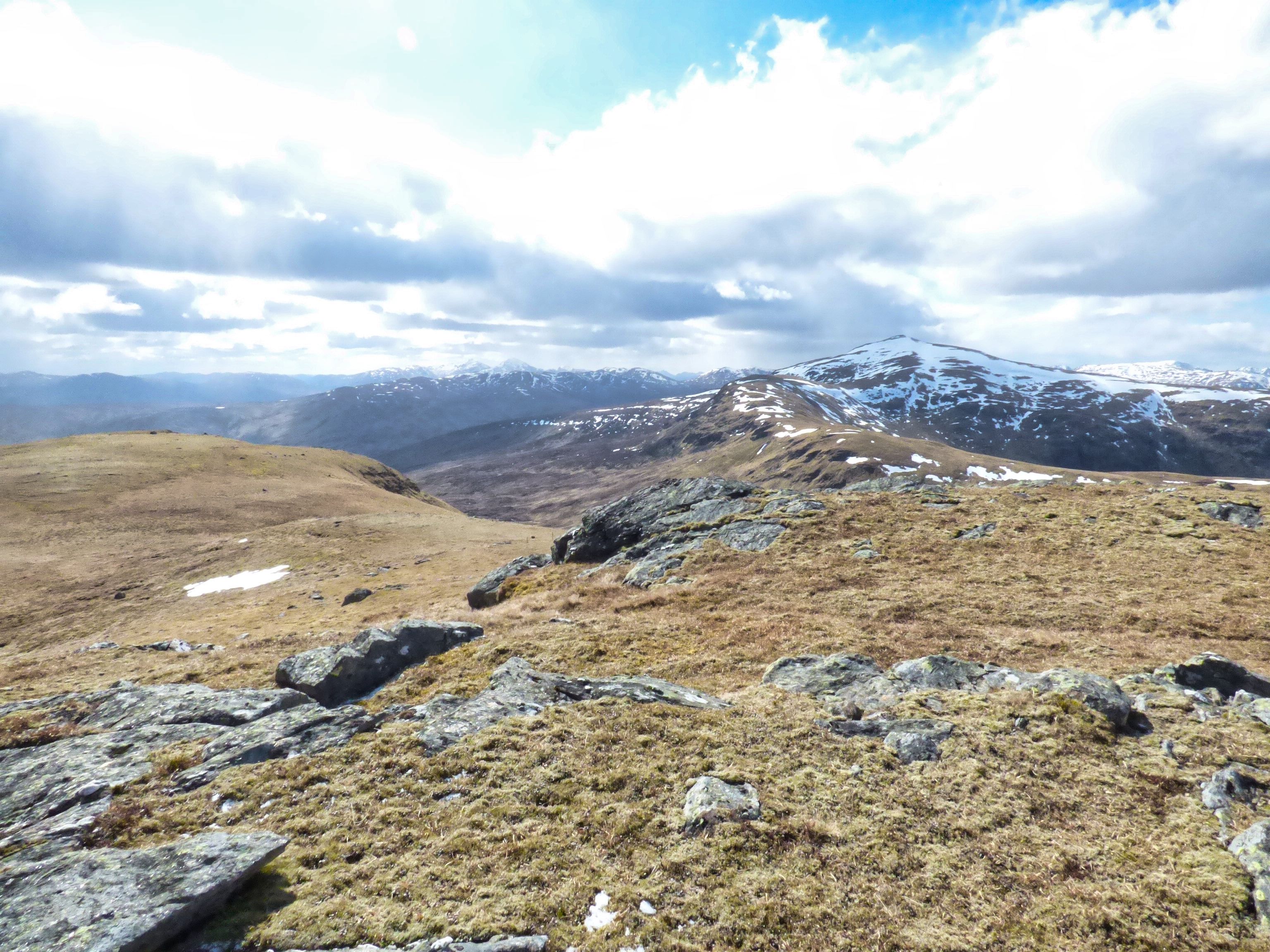
Ascent heading for the small tops
It is a very long walk in through the forest and in reality quite boring. There are some beautiful traditional trees but much more modern pine plantations. Occasionally there was a pleasant clearing giving some views, but alongside deer fences spoilt it a little. The wood seemed devoid of life, the occasional angry tit calling somewhere but really quiet, so weird. So it was a long plod taking just over an hour before the open countryside was reached. All burns crossed safely but the last one in the woods could be a significant obstacle if running higher.


From the shielings there is a faint track to follow for about a third of the ascent. There was a downside. Tracks attract water and at these temperatures the water had iced so I ended up walking through the tussocks preferable to constantly slipping.


About half way up I managed to lift my head and I spotted a red deer herd on the ridge, nice sight. Obviously they hadn't heard all the noises I was making as they stayed for some time.
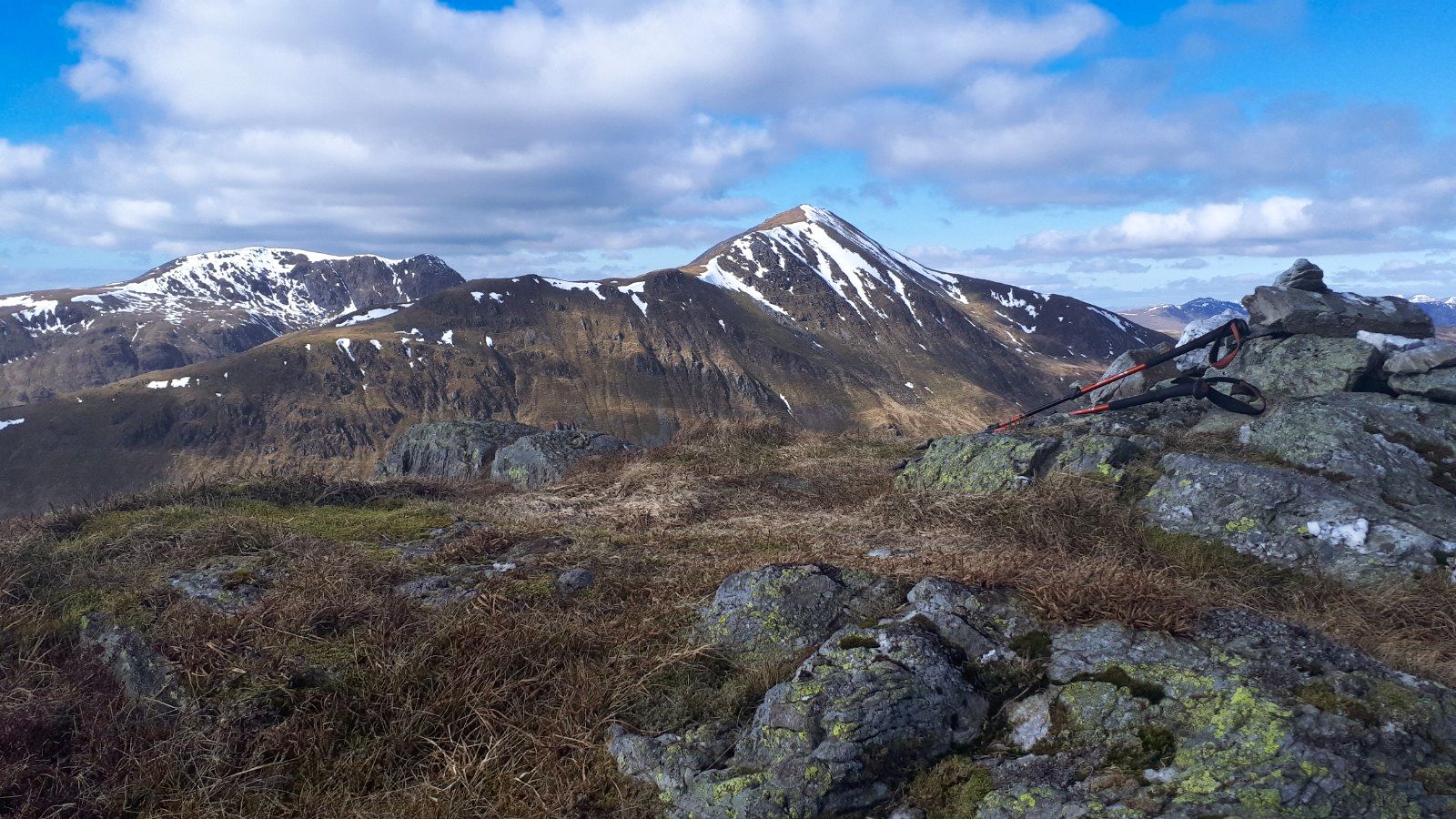
Lui hills

Summit

Dalmally hills

Looking east to Rannoch moor Orchy hills on right

The ascent was really just a constant plod up the grassy slopes before the summit plateau was reached. Bitterly cold but superb 360 degree views. Well worth the effort. Which ever way I looked snow speckled Munro tops surrounded me. Dalmally hills. Black Mouth hills. Orchy hills. Lui hills and many many more.

Descent aiming for corner pines, the long ridge of the Graham Beinn Donachain behind


Back down the same way. Ben Lui looked majestically alpine as clouds came and went leaving more snow on its flanks. That would be a a dodgy descent today.


Beard lichen Usnea filipendula

Still despite the barren forest there was a few interesting trees and it was a worthwhile ramble on a lovely day.

Ascent: 846m

Distance: 14.5km

Time: 4.36

Wildlife: Red deer; Blue Tit;