Saturday 27 May 2017

Hart Fell what a difference a day makes

A misty start
After Sundays dreadful weather day I was back at Moffat to redo the Hart Fell. Hart Fell 808m, is classed as both a Corbett and a Donald. The forecast was for Scotland’s warmest day of the year so an early start was made. I left the house at 6.20 and was on the hill for 8, walking from the green hut.
As you can see from the snap the fog/low cloud was almost a pea souper particularly as I started to climb. Luckily I had recent memories so I decided to go for it rather than waiting for the stuff to lift.

Not improving
Following Sundays route I was soon out onto the moor. There was a quad bike track to follow but it does have cut offs from time to time particularly to the left. Although I knew from the compass that I was moving in the right direction but it was also memory time as one bit of cut grass starts to merge in with the surrounding moor, particularly with this visibility. There is a significant drop on your right side but you should be aware of it.
There was the occasional noise of sheep and lambs calling. Twice a grouse was sprung. They give you a start at the best of times and today made it even more interesting.
For some reason the bio rhythms were not good today and I was struggling a bit, the poorest I have felt on a hill for a long time. Sweating much more than normal and generally a bad legs day, it happens but I had come all this way and I was not having two failures in a week, so head down and plod on.
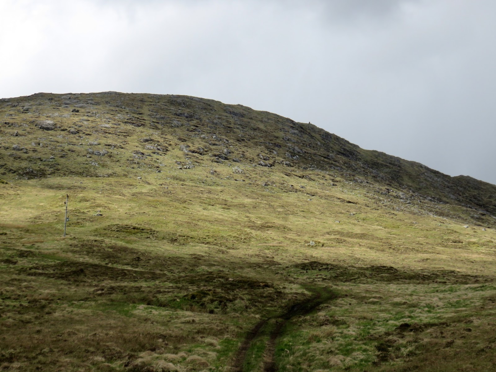
Breaking through
It was almost an hour before the light was brighter and I came out of the gloom into a bright blue sky and confirmation that I was on the right track.
I took my time as the emerging views were top drawer and spent as much time looking back as forward. The numerous wind turbines to the east were a disappointing sight.

Arthur's Seat
Before long I was at Arthur’s Seat and its small trig. Great views down the gorge and to the ridge of Swatte Fell plus the trail heading up to my destination. Across the top fence line a couple of deer are moving fast, did I spook them? Wild I presume and not escapees from the farm at the start.
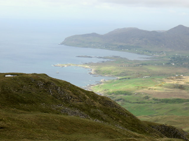
Wind Turbine abomination
This is not a difficult hill just a continuous uphill grassy walk and before long I had reached the summit plateau. I headed eastward the trig not yet in sight, just follow the small wire fence which I had to clamber over to get to the trig. Time taken 1.53 which was ok considering my condition.
The views were excellent even if the light was now bright and harsh particularly to the south. To the east the wind turbines must number around the 100 mark, an SNP abomination to the landscape.

Path over the edge
Still keep focused and enjoy the other views. The heat was now living up to the forecast, glad I was here early, more sun cream applied.
The path down
It was an up and down the same way day which was made more interesting as the cloud was only just breaking up constantly changing the views of the landscape all the way down.
Devil's Beef Tub
There is an excellent view of the Devil’s Beef Tub and the ridge to Whitehope Heights, a Donald trip for another day.
On the way down I meet a couple of ladies and later a single guy, my only companions on the day.

The end contrast with start photo
Another really good walk and a new area for my exploration. I am glad I returned quickly to embrace it and I will be back sooner rather than later.
Time 3.34
Distance 7.26miles or 11.68km
Ascent 2156ft or 657.15m

Friday 26 May 2017

Hart Fell part 1

On Sunday I was out for my first walk with the KRC group to climb the Corbett Hart Fell just outside of Moffat. I had a very enjoyable day except for the weather. All agreed that the weather forecast was completely different to the end result. On the drive down the clouds were a lot greyer and lower than expected.
Spitfire Moffat
First stop in Moffat was to visit a house with this full size replica Spitfire in the garden, wow. At this point the rain started gently.
When we arrived at the start the rain was heavy enough for most to don waterproofs, those that had not soon did.

Low cloud light rain but ok
A slightly damp tramp through a field of sheep followed by going past a field of farmed red deer. At this point we could see the route ahead and the rain slowly increasing.
Deteriorating
After a soggy tea break the walk continued until about 1700 metres when we the wind, rain and cold was making it no fun. Even good waterproofs were starting to let in water due to the driving rain. Plus without a view it was a tick box exercise so walk abandoned, the hill will be here for another day for the group but I will be back later in the week as good weather forecast.
Close to the end
Ironically when back home no rain and I talked to relatives in Edinburgh also no rain. We were very unlucky.

Sunday 21 May 2017

Beinn nam Beathrach Right day wrong hill

The trig will be slightly right of the gorge
There are times when you go for that unplanned hill and you get a pleasant surprise, this was one of those days. But it might have been different.
On a few occasions when driving between Loch Aline & Strontian I had noticed a prominent trig that I could also see from the hotel in Strontian. From the parking area altitude it looked like a quick hour or so up and down. It was our last afternoon and we had nothing planned. Plus I had read about a recent post about Beinn Chlaonleud decided to tick another Marilyn.

The masts and the hill
I was happily surprised that Mrs B wanted to walk after her exertions yesterday but we took the short drive to stop at the parking area beside the track leading to the two masts. The cairn prominent up to our right. Visibility was good, no need to check the map!! See later.
The cairn just visible slightly right
Immediately Mrs B stood in a black gloopy mudhole and was not a happy camper, not a good start. We followed the short boggy track to the first mast and then basically headed up the slope following the line of least resistance through the tussocky grass and wet patches.

Once we reached a steep section, hands required at times, Mrs B decided that was enough for her and she would sit, take in the view and do some sketching. Happy to let me go to the top, shades of Arran a couple of weeks ago with my pal. Time pressure again.


With the angle you no longer see the top so just keep going on your line. As you gain height many large boulders abound. About 30 minutes after starting I broached what I thought was the last level, no steep climbs left. I headed upwards on a right angle and before long I spotted the cairn away to my right. Now the brain starts functioning and I realised the problem, there was higher ground behind the cairn, so it was not the trig point.

Cairn over there, Resipole in the distance
I walked over to it and the views are indeed special, well worth the short climb, and yes I can clearly see the hotel as well as the hills Garbh Beinne I think, and its surrounding peaks. As I turn and look through the gap it could be Kentallen and the road to Oban. Resipole to my left.

So time to get the OS map out and then realised I was on Beinn nam Beathrach and not Beinn Chlaonleud. This cairn does not show on the map so not sure why it is there, just a better viewpoint from the one above? What a tube, on another day that could have been a serious error but today my concern was timings to get back to Mrs before she panicked. I had a phone signal but she did not, so no communication, txt just in case.

Through the gap Kentallen area
Luckily from the map I had completed almost all the climbing, the trig was only about 30 metres higher but about 10 minutes away to my north west. A quick hike meandering around the small lochans, a large plateau terrain, wish I had more time to explore, views opening up all the time but only time to get to the trig and immediately back down looking to my right at what should have been my target.
Balancing act
Well down the hill Mrs B could be seen pacing about, looking up and now glad we could see each other. Trekked back to the car where Mrs B put her foot in the same bog she had at the start, I could not believe it, more unhappiness!!
Again hoping for an eagle but nothing to be seen, not even any red deer although a few prints in the mud.
At least it is another sub 2000 completed, I did get to the cairn that I planned to, the views were superb and Beinn Chlaonleud remains for another day. Finally a reminder to look at the map before starting.
The trig is 582 metres but my ascent was only 301m. Time taken was 1 hour 23min (but if not in a hurry add another half an hour at least to walk around and take in all the views) and distance walked was 2.03 miles (3.27m).


Saturday 20 May 2017

Ben Hiant Ardnamurchan

View of Ben Hiant from Kilchoan ferry
On our way to Ardnamurchan lighthouse last year we stopped at the viewpoint overlooking the beautiful white sandy beach, Camus nan Geall. Beautiful as it was, it was the golden eagle gliding across the slopes of the hill opposite that attracted me more and I knew I had to get to that top.
There was no time to climb it last year but a return trip to Ardnamurchan made it a goer. By coincidence we were staying on Mull first and the view from our lodge decking was of an impressive hill across the water, maps checked, guess what, fate sealed it was Ben Hiant (Holy hill).
Another coincidence is that it is also in the book ‘The Hughs’ of which I am using to discover different hills. A good and energetic walk is described by Andrew Dempster from sea level. But as the good lady was with me we were going via the tourist route as described in Walkhighlands starting from the high point on the B8007.

That is a cairn?
The start at the tiny cairn is a laugh as this is the cairn, I think it has had some storm or people damage. Two other couples we spoke to had not even identified it and started well down the road. However once spotted the trail is evident, if on the right path it is a clear follow all the way up.
First plateau
An immediate stiff pull up the hillside gets the breathing going and Mrs already doubting the wisdom of her decision. As we reach the first top section I say ‘look those people are on the summit‘, she knows better but it encourages her. Just stop and look around, great views to be had early on and particularly when Loch Sunart opens up.
Middle climb
It is not too difficult a walk, just a steady constant upwards ramble as the path kindly twists and turns around the steeper sections. The only danger were the very strong gusts of wind which were capable of unbalancing you.
Final section and summit
As we look down into the glen below, which is between us and Beinn na-h Urchrach, we spot about 20 plus red deer grazing. Then, as the herd moves more and more deer appear, mainly hinds and calves but the odd stag is spotted, and we count 50 plus at one point, a great sight.
At this point the views of the final section looked a bit daunting to Mrs B but the track remains good. One short scrambling section and then the track winds it way around the back of the hill and before you know it the trig is in sight.

Well worn section
During the final section the views are once again outstanding despite the low cloud and poor long visibility. Looking back down Loch Sunart, Resipole the highest close hill, looking across to Mull with Ben More shrouded in cloud as usual, through the binos I can even see the lodge we stayed in near Tobermory.

Over now looking to Kilchoan and the Calmac ferry from Tobermory is arriving, plus the Ardnamurchan white needle of the lighthouse can just be seen. The islands to the west are also just in view but on a clear day it would be even more spectacular, probably seeing as far as the Uists. Then a couple and dog surprisingly arrive at the trig from a different direction from our route and tell us they have followed the Hughs route. They also say it is the coldest day of their walking holiday and are not hanging about, we concur.
A gentle descent taking in as much of the view as you can, it is well worth it and no need to rush particularly for her knees, she has done well and enjoyed it. You can just see the people ahead of us as small dots to the right. The white strip of beach just visible.
Looking back at the trail and descent
Apart from the red deer and a raven that was it, no eagles to be seen again.
Ben Hiant is a Marilyn at 528 metres. From our starting point it was 1127ft or 344 metres of ascent. Distance walked was 3.01 miles and took us 1 hour 10 to the summit.

Loch Sunart and Morvern

Kilchoan
Another cracking hill with plenty of views to remember. Then it was off to the Natural history centre at Glenmore for coffee and cake, superb. Worth a visit for the unusual local crafted gifts, a lot of money can be spent, be warned!!

Monday 15 May 2017

Early morning walk on Speinne Mor Mull

Hill profile from the west
An early start this morning as the weather forecast was predicting rain by lunchtime. I was awake early anyway with the dawn chorus and as such was at the start of the hill for around 7.30. Today’s objective another Marilyn on Mull, Speinne Mor.
Grey and overcast, but not cold, anyway full rain gear on in anticipation.
There is parking on the left immediately after the last loch but take care not to stick out, it also acts as a passing place.

Walk starts here
The fence and stile are immediately evident, go over and start following the track. This is clearly a well used hill from the number of footmarks dug into the muddy uphill track. The heads of the ferns are coming through, later in the year the track might disappear when they mature.
Overall there is no difficulty on this walk in today’s conditions but up top it is a very remote moor, so on a low cloud bad weather day it could get interesting, particularly on the summit plateau. This is a rather barren landscape. Not even sheep grazing to bring a farmer up. The only other person you are likely to encounter is another walker, but nobody at all around today. Still the positives, the sound of silence and isolation, apart from the sounds of wildlife and my breathing.

3 lochs plus S Airde Beinn
The stiff pull got my breathing going and the good views over the 3 lochs on my left kept me interested. Yesterdays walk S Airde Beinn is the high point. An early morning angler is rowing a boat out, he was not there when I returned, maybe caught his catch or too windy. A couple of meadow pipits were my only other companions.
Summit plus Loch Frisa
Once over the initial climb the terrain flattens out at Sron na Beinne Creagaich and you get your first view of the objective, it looks a long way away in this light. This section was generally good walking but still boggy in parts, enough to go ankle deep in mud at times. The weather has been remarkably dry so I can imagine that this would be very different after a wet spell.
There is still a good track to follow, you lose it at times but soon catch it again.
Loch Frisa is clear on your right, I was hoping to see one of its resident sea eagles but they were no doubt sitting on their nest waiting for the weather to improve.
A line of rusting fence poles gives another line to follow, particularly handy if the visibility was poor.

Final climb
Now cross the very small burn, Allt a Chiogaid, which flows from Lochan Dearg, of which you will get better views soon.
Open summit moorland
Another short uphill section continues until the ground levels off. Almost immediately there is a very small pile of stones where you turn left and follow the faint track, moving uphill across the hill. Don’t worry if you miss it, I did, saw it on the way back. Just head up towards the nearest high point and keep doing that. It is a teaser of a top, you keep thinking that you are there but the trig is still a good bit away.
Ferns out at trig
Finally I reach the stone shelter which circles the trig, 444 metres and it has taken me 1 hour 18 minutes. For a short time I have had the view down to Tobermory on my left. Sadly with the poor visibility I can only imagine the stunning 360 degree distance views that I would get on a clear day, not even Ben More could be seen. Just as I took my trig snap the pitter patter of rain began to hit my bare head.
Lochan Dearg
The return is by the same route but as always that is the time for me to take in the views and the landscape. On this bare moor I fully expected to see red deer but not one spotted until I was almost back down, grazing near the loch. A skylark rose and a grouse called but that was it.
A good view of the lochan but too far across that ground to explore.

Marsh orchid?
There were a couple of orchids that I spotted, one a pink base with deeper spots which I think is the early marsh version, happy to be corrected. The other pure white which I‘m told might be another early marsh variety. Then I came across this rock with the most amazing colours, what a sight, a pleasing end to the walk. Time for brunch.
Colourful rock
Glad to say the rain did not come to much but the long views remained poor.
Trip stats: Overall walking distance 5.68 miles (9.14k)
Time: 2 hours 42 minutes
Ascent: 1213 feet (370m).

Sunday 14 May 2017

S Airde Beinn A wee hill on a wet grey day

Woke up this morning in Mull and checked the BBC weather app. No rain this morning it showed, as I listened to the rain hitting the roof!! Checked the XC site which indicated showers all morning, correct.
So a small hill chosen as the good lady joining in.  S Airde Beinn, also known as ‘crater loch’. Only 5 minutes drive from our place so perfect.

Enter here
As described in Walkhighlands route we parked beside the ruined cottage. Geese honked on the opposite Loch Meadhoin, but not a day to be out on the loch fishing, the wind was whipping up the waves.
Earlier in the week it was summer shorts weather, today full raingear on.
Go through the gate and follow the obvious path. It is a small hill and has no difficulty for most. As the last month has been very dry the path was easy to walk but clear evidence that it can be a wet and boggy path.

Follow the path
Head for a fence ahead, go through and up the path following slightly left of centre. The peak is right in front of you. The faint right side track is the descent route but we did not use this, see later. A cuckoo calling lets Mrs B hear her first of the year. Some meadow pipits rise and a raven flies over looking for their nests.
Looking back
A brief climb and you are almost at the top, the water is in sight in the bowl of the volcano. Looking to your left there is a barren landscape but we spot 3 red deer sprinting across the moor, did we spook them?
First view of the crater
We are walking around the lochan in a clockwise direction. The first cairn is at 285m but the left flank is slightly higher at 295. The next cairn at the north is 292m on the OS map.
View from north
Despite it being a grey, wet day the views were teasers of what would be available on a clear day. The full 360 degrees throws up peaks in 3 directions, Ben More definitely, Ben Nevis a possibility. Coll & Tiree another certainty. Tobermory below, a Calmac ferry sailing through heading to Oban.
A hint of the view
Still it is surprising cold in the wind, the constant light rain just not letting up.
We went back over the first hill to get the last views rather than follow the lower path beside the forest edge. We get a close up of a flying cuckoo.
Despite the poor weather it was a good short walk that I would highly recommend particularly in good weather. Minimal difficulty.
Walking only 1.95 miles with a short ascent of 435 feet. Go for it.

Arran Coastal Way Lochranza loop via Fionn Bhealach

A quick return to Arran to complete the Sannox - Lochranza leg of the Arran Coastal Way.
The weather this week has been great, big blue skies with at times a chilly NE wind. Today is similar.

Postie's trail
I have an occasional walking pal with me today and our walk began at Lochranza distillery. Our timings were pretty tight to catch the bus from Lochranza for the 16.40 sailing back but if we do miss it at least there is another ferry albeit with a lot of hanging around.
We set off walking up the postie trail to Laggan. A very pleasant gradual climb. We soon hear and then spot a cuckoo closely followed by some red deer fairly low down, two of today’s targets for my pal. As we gained height I spotted something reflecting in the sun high on a hill, then there was movement on Torr Meadhonach. Binos out and it was at least 4 walkers who I reckoned we should be close to when we reached the top of this ridge pass at Bearradh Tom a’ Mhudie.

Views opening out Torr left and Fionn right
We were also catching up a solo walker who had been on our bus and then we spotted another group heading up to Fionn Bhealach. What is going on? It is like Sauchiehall street today.
We did catch both parties; the fit old guy was on a day trip from Glasgow and the group were kids plus teacher doing the Duke of Edinburgh assessment, compass and map reading skills, they got lucky with the weather, full lines of sight.

Pick a line and go straight up
We headed out into the tussocky grass, no path to follow, pick a line and go for it, mainly dry underfoot but many boggy patches of moss, high dry reeds, and areas of eroded ground to manoeuvre round. It quickly became too tough for my pals fitness so with his permission I left him to continue to enjoy the views and have his lunch, whilst I did a solo to the top.
Fionn Bhealach final ridge
I had budgeted for 40 minutes to Fionn Bhealach and back but in reality it took an hour, the terrain was rather poor for my speed walking. In a couple of months time when the ferns have grown and the ground possibly wetter it would be a proper challenge. The views were superb but I did not stop for many snaps as I wanted to get back before he thought I had got lost. Luckily he could see me for most of the way.
Looking north on descent
We met up again, my pal had enjoyed his relaxing lunch whilst I was eating on the hoof and we quickly headed down the track to Laggan cottage. Enjoying some great easterly views whilst descending.
The track does continue to Laggan cottage
We were pushing on now aiming for a point in the distance which I thought was the Cock of Arran, our immediate destination. Just like up on the hills it was a teaser, once we got there another point lay ahead. The path was now much harder going. We spot a small digger which is being used to improve the path away from boggy land. It only becomes apparent later as we debate how exactly did that digger get there?
New track
The question is asked as the next stretch across the An Scriordan boulders is a very challenging and seemed at the time a long arduos section. I can fully understand how some reviewers have been caught out by this, it slowed us down. Looking at the GPS data later the temperature was in the high 80’s for about 30 minutes of this sheltered leg dropping to mid 60’s when we finally turned the northern tip and hit the westerly wind.
The end of the boulder field
From the map I knew we had missed Ossian’s cave, I was looking for it but maybe just pushing too hard?
Time was definitely not on our side so I had to encourage my pal to up the pace, his non recent walking was catching him out fitness wise. We pass the cottage at Fairy Dell and stop briefly at Hutton’s Unconformity. Impressive pink coloured sandstone and granite with green seaweed to add colour.


As we turned the point at North Newton the westerly wind picked and so did our pace. We could see some housing in the distance but of course the bay was in-between us and the bus.


The final stretch should have been enjoyable but for us became an army yomping session, easier when you are young and fit but not so cool at our age.
It was low tide so we were able to cross the high tide area, feet had to get wet but needs must. We arrived at the bus stop with 3 minutes to spare, far too close for comfort. Of course the bus was 5 minutes late but there you go.
The 4.5 miles stretch from Laggan caught me out and again took longer than expected.
Nevertheless it was a good day out, with 10 miles covered in 4 hours of very mixed walking, ascent just under 1700 feet. Memo to self, next time catch the earlier ferry and give yourself more time for that reward of coffee and cake.