Sunday 29 January 2017

Forth & Clyde Union Canal Kilsyth - Stockingfield Junction


Another section of the canal trek completed and this time I decided on an east to west walk. To my mind it was better to arrive in the city at the end of the walk than vice versa. 
My day started with a couple of train journeys, just like going on holiday, from Ayrshire to Croy. From Croy I had a walk of just over a mile to get to the canal itself. Still, as I have never been in Croy itself, I have passed through many a time on the train, it was a new experience so no hardship.

After leaving the road about half a mile in you are directed down a track. The signing has disappeared and from my google earth review last night I thought I would stay on the main road. This track was taking me eastward, away from where I thought I should be going, but just before doubt fully set in the track turned north and the canal was right there.
Auchinstarry Basin
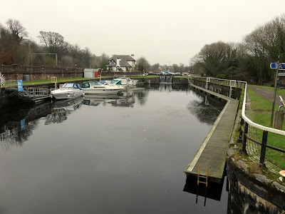
A cold frosty morning with plenty of ice, thin I presume, on the water. Heading west there is a multitude of canal boats moored up just ahead of me, more than I have seen at any location on the walk so far. It is Auchinstarry basin and apparently has berths for 50 boats, probably all here today. Some are well and truely iced up, I suspect living on a canal boat in winter could be a hard life.
You then have to leave the canal to cross over the main road, yes I presume the one I mentioned earlier, and on the other side head westward young man.
Its still cold here typical path
Apart from the last couple of miles into Glasgow this is a totally rural walk but don't expect much else along the way apart from the canal and the countryside. More than enough for me but others might be disappointed, not much local history to get educated by.
Pink Footed geese
Surprisingly, unlike the Bowling section, this stretch was almost devoid of canal waterbirds. One pair of Goosanders, a couple of Grey Heron, the ubiquitous buzzards, an occasional moorhen and that was about it. As the canal had a fair bit of ice along the full length of the walk that might explain it but I suspect not. In a field a large flock of geese were spotted, I think these are the Pink Footed goose.
Campsie Hills
For around the first third of the walk the Campsie hills are prominent, the hazy light today looking like summer not winter. Kilsyth can be seen, maybe not the most attractive.
A good hike and Twechar is reached, I spent some time mentally debating how to pronounce it. Not much to see, like most of central Scotland mining was its fame and fortune, now long gone. 
Shirva Stables
After passing the village I come across this ruin which I believe is the Shirva stables, where the canals Clydesdale horses were stabled. Real horsepower to power the boats back then. The teams of horses were rested overnight, it is said they were looked after better than the canal labourers. But all gone now.
Kirkintilloch
Onwards to Kirkintilloch where an inland port was built and the town thrived on building canal and ocean going boats. Whist walking I assumed 'Kirk' in the titled related to the the large kirk I was looking at. Later, on the train home, the internet tells me otherwise, it means fort at the head of the hill. It has history from the 1200's, no time to explore today but I will be back. It also was a totally dry town, ie no alcohol, until the 1970's. No place for me then.
Easy walking towpath
Out of town and heading towards Bishopbriggs. The signs have changed from the green canal ones to blue Thomas Muir ones! Really, walking in Scotland can be made easier. 8 miles in so time for my cheese & mango chutney Glasgow roll. The chutney was bought in the Rothiemurchus farm shop and highly recommended by me. Complimented the Orkney cheddar perfectly. Apple as well for the healthy bit and onwards again.
There is not a lot more outer canal highlights until you reach the Possil marsh nature reserve. Typical nothing to be seen apart from a couple of magpies. 
The final couple of miles remind you that you are in a lesser social area of Glasgow. The verges are well littered with empty booze containers. Some guys shouted from the other side, glad there was no easy way for them to get across, the appeared well high on something. Since the Bishopbriggs cut off there had been nobody else walking the path, a little spooky.
Broken tree
One point of interest was this amazing dead tree, split through old age or lightening, I don't know but made me smile.
But finally I made it to Stockingfield junction. After yesterdays climb up Blaeloch hill my feet were feeling it so I decided the walking was over and it was time to get a bus into the centre, relax with a pint and get the train home.
A good day with 14 miles covered in just over 4 hours. Only 2 more sections to go to complete the walk.


Thursday 26 January 2017

Blaeloch Hill

It was a brilliant but cold blue sky morning and my dilemma was whether to climb Kaim hill from a different direction than my previous blog or try its neighbour Blaeloch hill. I felt that it was just too close to my last attempt at Kaim hill so opted for Blaeloch.
If you want it to be, this could be one of the easiest hills to tick off. I did not realise at the time that you can follow the windfarm hard packed route almost all the way to the summit, but, unless you are in a hurry, or not fit enough for moorland tramping, then I suggest don't.
The track ahead Brown hill on left
I parked the car at the wind farm entrance, parking for about a dozen cars as cars can go no further, and with a pretty cold icy wind blowing. Starting at this level you have far less climbing to do, one bonus. Well dressed I set off up the track. The sun was so low in the sky that it was difficult to look too far ahead. Also apologies for photo quality, not the best in today's light. I intended to follow the track round the back of Brown Hill then go off track. Going round the hill I squinted up and I could see what looked like a trig/cairn up to my right. 
False summit and typical moorland walking terrain
It seemed a bit soon but after a mile or so I just picked a spot and left the track to aim for the cairn. Being stupid today I had not brought my walking poles so I picked my way carefully through the moorland tussocks. One advantage of a very cold night was that a lot of the boggy stuff had firmed up so walking wasn't too bad although I imagine that this could be a very different walking surface at other times. There is no tourist track so just find a sheep track and follow until it vanishes and then try and find another.
The faint track & to the true summit
I was concerned that there might be grazing hill cattle but thankfully only sheep today. I spot a shepherd's quad bike trail and follow this for a while until the the cairn comes into view and the tracks disappears. A quick pull up and I am there but as expected it is a false summit, I can see what I think is the real one in the distance. Why build a stone cairn here, it must mean something to someone I suppose.
There are good views back the way but north and west are shrouded in cloud and mist, which is a disappointment.
Now there is a thinly marked trail, more prominent than a sheep trail and for a while making the walking easier but still plenty of wet patches to get across.

Suddenly I see debris ahead and think an old tractor has been abandoned. Closer up it is clearly aeroplane debris, some significant pieces. On inspection the crater where it hit is clear to see. Time for a moment's reflection that someone obviously died here, was it bad weather, lost in cloud and mist, who knows but thought provoking.
Blaeloch cairn
Now I see the what I presume is the Blae loch, it is not very big, a lochan would be my more accurate description. Then a short clamber up to the cairned summit of Blaeloch hill. I can imagine that the views from here would be stunning out to the west in better conditions. The way the hill is angled you cannot see down to either Largs or Fairlie but you do see Cumbrae. To the south Kaim Hill stands clearly and behind me the wind farm and its turbines, the blades of all bar one rotating away, more profits for the Spaniards or whoever owns them but no cheap power for us. I sit and have my lunch with these out of sight.
Don't look this way
Also I now spot, a very short distance away, the marker post for the Fairlie walk which joins up with the Kaim hill walk in a previous blog. A hop skip and a jump and it's the wind farm road. So, as mentioned earlier, you can walk almost the whole way.

On the leisurely wander down there are good views north, including more hills in the Clyde Muirshiel regional park, one of which, Hill of Stake, is on my to-do list.
Following the track back down I reflect on how little wildlife I have seen today, a couple of ravens and a calling pheasant low down. But not one of the expected moorland birds whatsoever, not even a call, surely that can only be down to the environmental damage caused by the wind farm.

When almost at the carpark I look across to the small hills opposite and see a line of 4 buzzards holding station looking for voles etc. 3 pairs of raven can also be seen. Worth reflecting life across the road, none this side.
So a short but interesting and worthwhile day. If you want a rather more strenuous outing the hill can be climbed along with Kaim Hill but better if another car was parked at the Fairlie end. My own days climbing was only just over 700 feet but it was a good walk on a cold spring day. It's full altitude is 407 metres so I covered about half of it. Blaeloch is classed as a sub 2000 hill.
The impact crater & debris
PS: an internet search confirmed the air crash as a Fairey Firefly which took off from Ayr on a navigation exercise in Oct 1944, never to return. Both aircrew were killed.


Sunday 22 January 2017

Forth & Clyde Union Canal Bowling - Spiers Wharf

Another leg of the Forth & Union canal today. I apologise for any confusion but I am doing these in stages so the the blog can go east to west and vice versa depending on my travel arrangements.
View from Bowling Station
Public transport today so a train from Barassie to Glasgow, then to Partick and finally another one to Bowling. Left the house at 8.50 and started walking at 10.35. I must say the train stock from Glasgow central was some of the oldest trains I have been in.
The normal route goes from Bowling to Stockfield Junction before heading towards Kilsyth but today I followed the spur into Glasgow onto Spiers Wharf. According to the 'Walkhighlands' site the walk is around 9.75 miles. But today because I started at Bowling railway station and finished at Speirs Wharf my actual walking was 15.31 miles, no wonder my legs were tiring.

By definition a canal walk is alongside a calm and non moving piece of water and could potentially be quite boring. For me it is the journey and although I know Glasgow I have never experienced it like this. I come across new, to me anyway, local history which helps expand the mind.
Cycle map but it shows the route
Today is principally an inner city walk traversing outside greater Glasgow's western flanks, heading north and finishing not far from the city centre. Although it is a city walk I was very surprised at how tranquil it was for much of the trip. Also, relatively few people on the path, it was a Friday and a school day but still? These canal paths are underused and sadly so is the water, not one vessel moving on the canal today.
The start at Bowling
As mentioned I started at Bowling station and as such I had a 1/2 mile walk to the canal basin. There is a cafe/takeaway shop in Bowling and a cafe at the canal basin if you want refreshments. Plus there are loos at the basin. A warning this is city walking and not many spots to take a toilet break if required.
This opening stretch to Clydebank is the slightly rural stretch, hills to the left but not much viewing too the left. Soon walking under the Erskine bridge. I have driven across this so many times it is a highlight to get this view from below.
At Clydebank the canal and a shopping centre merge, footbridge across the canal, apparently it goes smoothly when boats come through. More opportunity here for a rest and/or food and drink. 
The drop lock
Just before the shopping centre is an engineering achievement a drop lock, the only example of its kind in Europe. Its purpose is too allow canal traffic to travel underneath the busy road, see even more history.

Also just before the shopping centre is the Beardmore sculpture, a historically important site to the community, up to 13000 people worked at the naval shipyards. The ship in the structure is the dreadnought battleship HMS Ramillies which was built here.
I'm afraid the next stretch shows our population at its worst as behind the back garden of almost every house they have tossed all sorts of garbage, to be collected by who, very sad? 

Not a lot happening until approaching Kelvinside and Maryhill locks. A double gas storage cylinder, don't see many of them these days, I presume these are unused now.
Maryhill locks
Then then canal crosses the Kelvin aqueduct, when built this structure was the biggest aqueduct in the UK. Walkers in that era could see ocean sailing boats passing above them.
It is worth spending a few minutes at Maryhill locks, 5 gates with a large pool at each to allow boats to pass each other. Also there is some interesting street art on a nearby tenement.
The split
Shortly thereafter the canal splits at Stockingfield junction and this is where I will start my next leg heading to Kilsyth. However, today I am continuing into Glasgow centre so my route is no diversion just continue along the footpath.

Walking on through the Maryhill district you pass Firhill stadium, home of Partick Thistle. There are bright lights on the machine sitting on the turf, I presume some fancy grass growing technique.

The journey is almost at and end. Good views looking over south and west Glasgow from this height. Plenty of new housing built in this area and journey's end has an old industrial unit converted into flats across the canal. 
This is Speirs Wharf and the end of the walk today.

I come across a scenic footbridge going over the canal, very pretty in the surroundings.

With a few detours I have covered almost 15 miles in around 4 hours. It has been a busy walking week and the legs are feeling it. Time for a pint and then a train home.

Thursday 19 January 2017

Kaim Hill part 1

Fairlie Moor
The incredibly unusual temperate climate for mid January is perfect for getting outdoors early in the season. After last weeks storms and snow the mild air (from the Canaries apparently)  has removed most of the snow, at least down here, so time to get a lung blowing uphill outing.
My original plan was to go to Luss and bag a couple of new Grahams, Beinn Eich & Doune Hill. But, although the forecast was to be mainly dry, it also had some showers with heavy low cloud. If I am going to put this amount of effort in I want the views so parked this for another day. My default local choice was Kaim Hill, a lower hill, but this would be a first for me, so a good alternative, plus only 30 minutes driving. A search of the internet and also some of my guide books and the route option from Fairlie station was chosen.
As forecast the clouds were a deep grey, the wind was stronger than yesterday and dry so far, so geared up off I went. 
A left turn at Fairlie station and heading along a narrow lane to soon follow the sign pointing to the right, directly past the front door of a cottage, and then follow the track, through the wood, up the side of the Fairlie burn. Birds are singing in the bare trees, so springlike. The snow melt has softened the ground so means a very muddy track but also fast running water in the burn, the noise level increased by a multitude of small waterfalls. I have to cross this burn at some point later, no bridge apparently!! After only 10 minutes it is already time to offload the mid layer thin fleece, too warm, and don the gaiters for mud protection. Glad I brought my walking poles as the ground very slippy.
A short way up a modern fence blocks the way to Fairlie castle and diverts you to the nearby path. The castle is now apparently private property and is being renovated, local access disputes ongoing.
Breaking the treeline
Continue uphill and as the trees open up a little to let in the excellent views you are met with 'the moor' sign. I always think that there is a slightly ominous feeling when coming across signs for a moor. For me the connotations of an open moor are akin to Sherlock's case, the Hound of the Baskervilles, wide open poor ground, bad weather, with few people around and lots of danger lurking. Probably very true apart from the hound.
No crossing here Lairdside hill straight ahead
The burn is still roaring noisily away on my right as I break the treeline and I now have sight of the open moorland ahead. There is a path of sorts but there is also a lot of bog, probably it is here the full year round. A stile is crossed and it is worth stopping to stand on the top, look back,  and take in the views of the Forth of Clyde, beautiful. Sadly you cannot ignore the views of Hunterston power station and the coal docks.
Ahead of me are sheep, moorland and the tops of wind pylons. Thankfully I don't go right to these pylons. A buzzard flies by as do two calling ravens. A sheeps skull on a fence reaffirms that not everything survives up here.
My guide says to cross the burn as soon as you can after leaving the trees but deep gullies indicate not yet, keep following the muddy track.

At the signpost for Kelburn wind farm or Kaim there is now an opportunity to cross the burn. Take it and continue uphill following the the line of the fence and a boundary wall. 

Cross here
The wind has strengthened and it has got noticeably colder. Looking back I can see rain showers further north and the Loch Lomond tops are now covered in cloud, so good choice made earlier not to go there.
Looking to Kaim hill from Lairdside hill
I have reached the top of Lairdside hill and its small stone cairn, this is a very remote top. I can see the trig point of Kaim hill on my right but there is no obvious track leading to it. It looks like a descent and ascent of around a mile on really crappy walking, at least so far there was a boggy track. The tops of the wind pylons to my left are being encircled and then released by the encroaching low cloud. It is a bleak landscape and I have seen no other person on the moor, not even a shepherd. I have my compass but decide not to venture further today. If I had company then I probably would have went on, but on a short daylit day, with the cloud coming down, a moor is not the place for a lone walker to get into difficulty.
Wind turbine disappearing
So back down the boggy track I go, in no rush, soaking in the Clyde coast views.
Without anticipating danger, my foot goes straight into a hidden boggy hole, entering well over ankle deep and trapped solid. If I had not been leaning on my walking poles and fallen over, a twisted or broken ankle would have been a real possibility. As it was it took an effort to release my foot from the boggy suction. It rather reinforced my decision to not take the chance. The hill will still be there for a better day. Then, it dawned on me. that I had forgotten to pack fresh socks, wet feet for the drive home, another lesson learned.
Hunterston & coal area Arran beyond
The remainder of the descent was straightforward and ended with a nice chat with the owner of one of the cottages at the station.
Back home, whilst studying Google maps etc,  I indulged in a couple of cans of Drygate's Orinoco breakfast stout, a very fine tasting beer. Next week I will tackle Kaim hill again but this time from the Fairlie moor road side. Here's hoping part 2 will be a success story.
Looking north Argyll & Holy Loch
Despite not meeting the hill objective I did meet the exercise objective and got in some good preparation for the hills on this years planner, flat walking keeps you fit but does not adequately prepare you for the hills. The distance was only 3.33 miles but included 1011 ft of ascent so it gave the lungs and heart an outing. The views were superb at times, I was outdoors, what not to like.

Friday 6 January 2017

River Ayr Way Sorn - Stair

River Ayr Sorn
Happy New Year and the first major ramble of 2017 that merits a post.
There is no such thing as a bad walk. There are circumstances that might affect the walk but being outdoors is king. I know you can sense a BUT. Today's walk was a good one, a lovely crisp winters day, great scenery, some wildlife, a nice pint at the end, BUT the walk title is a bit of a misnomer. The long distance path is called the River Ayr Way, so you might think it does just that BUT as mentioned in my Stair-Ayr blog it digresses from the river for nearly half the walk. Still, I really enjoyed it as you will read AND I encourage you to do this, or at least the river sections.
I had two travel options, I could have got public transport but that would have involved 3 buses, would have taken 2 and a half hours hours, and with a tight turnaround at each stage it was not worth the risk of a traffic delay, missed bus, no walk. So onto my second option, Mrs B got up early and drove me to Sorn. Only 35 minutes and winter daylight time saved.
Sorn Bridge, Kirk, Graveyard
The car was showing -2 degrees at Sorn it was a cracking winters day. The light was magnificent,so good I took a snap upriver. I began the walk in the 'Main' street, probably called something else and walked west and crossed the old single track bridge across the River Ayr. The first 4 miles or so of river walk are quite something. The bridge (around 400 years old) stands opposite Sorn Kirk and its ancient graveyard, with some very interesting and old headstones if you have time to look.
A good track
Up the hill and quickly off road with good views of Sorn castle and another large marquee in its grounds, more weddings? Quickly thereafter the path descends to the river where you follow a good path to Catrine. It has been a cold night as you can see from the icicles in the branches just above the river.
Blurred icicles
At this time of the day the sense of isolation and tranquility is paramount. Only the sound of running water, birds calling in the trees and top notch unspoilt scenery, this is what it is all about.
Tranquil River Ayr
About 2 miles on you reach Catrine with the old industrial mill water driving weirs and holding ponds plus the newly constructed salmon ladder, great to see.
You depart from the river and aim to find the town square, it doesn't quite meet my expectations of a square to me, but, I ask a local and the burn crossing at 'Bridge St' is just ahead of me. Turn right and along the river we go, next destination, the new A76 Howford road bridge. Catrine is the last stop for food and drinks unless you want a longer detour to Mauchline later on. I get a brief sighting of a grey wagtail happily making its way along the opposite bank.
Salmon pass Catrine
Walk under the A76 bridge avoid the more obvious left track and go down towards the river to cross the Old Howford Bridge (built 1750 wow getting on for 300 years, solid construction) and head up the track. Sadly, not for the only time on this walk, fly tippers have dumped their domestic rubbish at the trackside, scum.
A left turn across a small field leads you into a ravine with magnificent compressed rock formations that make you think about the forces of nature that created these layers. I read that there are prehistoric cup and ring marks as well as modern graffiti. I think I see some possible examples but really an expert eye is required.
Rock layers
Now you have the equally magnificent, of the modern variety, Ballochmyle Railway viaduct (a train went over so still in use), which has as its claim to fame the longest masonry railway arch in the UK. The path is still in good condition but going up and down regularly so stretching the leg muscles.
Ballochmyle Viaduct
Enjoy the sounds of the running water as shortly the walk now leaves the river and for almost 4 miles is an inland countryside stroll. In parts it is public tarmac road, no pavements, take care particularly near Failford. It is also miles of fenced pathway, meaning direction is no issue and no livestock either is disturbed by you or vice versa. Some people complain about this herding but I will go for it as it keeps you safe. But why could it not be incorporated on the riverside that the landowners won't let you walk. I can only imagine it is fishing rights but I could be wrong. However, it does not keep you safe from growling angry dogs running free and well away from owner, at times some sort of spray as a safeguard would be welcome, probably illegal, and not even a sorry from the owners.
Herded in cannot get lost
At the hamlet of Failford I fancied a pint and a sandwich but the Inn was closed. Back to the emergency rations. A left turn takes you down into a stretch, known as the Ayr Gorge Woodland and a stunning section it is. It is managed by the Scottish Wildlife Trust and a good job they are doing. Good walking and informative information boards. The river is cut into the gorge which has colourful sandstone rock formations, a reminder that Scotland was once attached to Africa, our geology is based on sand and this is a spectacular reminder.
Sandstone gorge Failford
A little later I was aware of my backside feeling colder than usual. Investigation found a very wet rucksack bottom, I had put my water bottle in the rucksack upside down, obviously with the top not sealed, a wet rucksack and lower jacket. Thankfully not far to go as nothing left to drink.
The gorge has several sets of steps both giving regular ascending and descending, a bit of breathing blowing, not such a good fitness sign. There are super views at times of the river meandering way down below when walking these upper sections.
A final climb breaks you out of the woods and back into open countryside. Then back down to the river for a short stretch until you reach the detour (a stile leading to a short field crossing) at Daldorch farm. Apparently a couple of landslips further on near Stair have rendered this river section impassable. Now it is about 3/4 of a mile away from the river on tarmac and a final section on a twisty busy road so take care.
Detour at farm ahead
Finally I called the good lady for my lift. I deliberately left this until late on so that I could have a pint of real ale in the impressive Stair Inn, well I had earned it.
12.52 miles in total taking 4 and a half hours with just over 1000 ft of climbing. A fine walk on a fine day in beautiful Ayrshire countryside the vast majority never see. Enjoy.