Showing posts with label Aberdeenshire. Show all posts

Friday, 20 December 2024

Wild and windy on a Pictish hillfort tour.....Bennachie

Hill: Bennachie (The hill of the nipple or pap)

Type: Sub2k

Height: 528m


Plan A had been to tick off the Fiona of Hunt Hill but the weather forecast had changed big style since yesterday. Although the air quality was to be excellent the winds were forecast as exceptionally strong. Indeed the MWIS forecast for the Eastern Munro summits was ‘Impossible to walk’, I have seen all sorts described but never seen impossible on a clear day, but take heed I must.

Plan B was to visit this renowned Pictish hill fort circuit. For some reason on Walkhighlands it is named as Bennachie after the range of hills, but there are two hills to visit, neither named Bennachie and only one of them is a Sub2k, despite just 10m of height difference, very odd and more later. This circuit has been on my to-do list for a few years so it was a good opportunity to get it done.

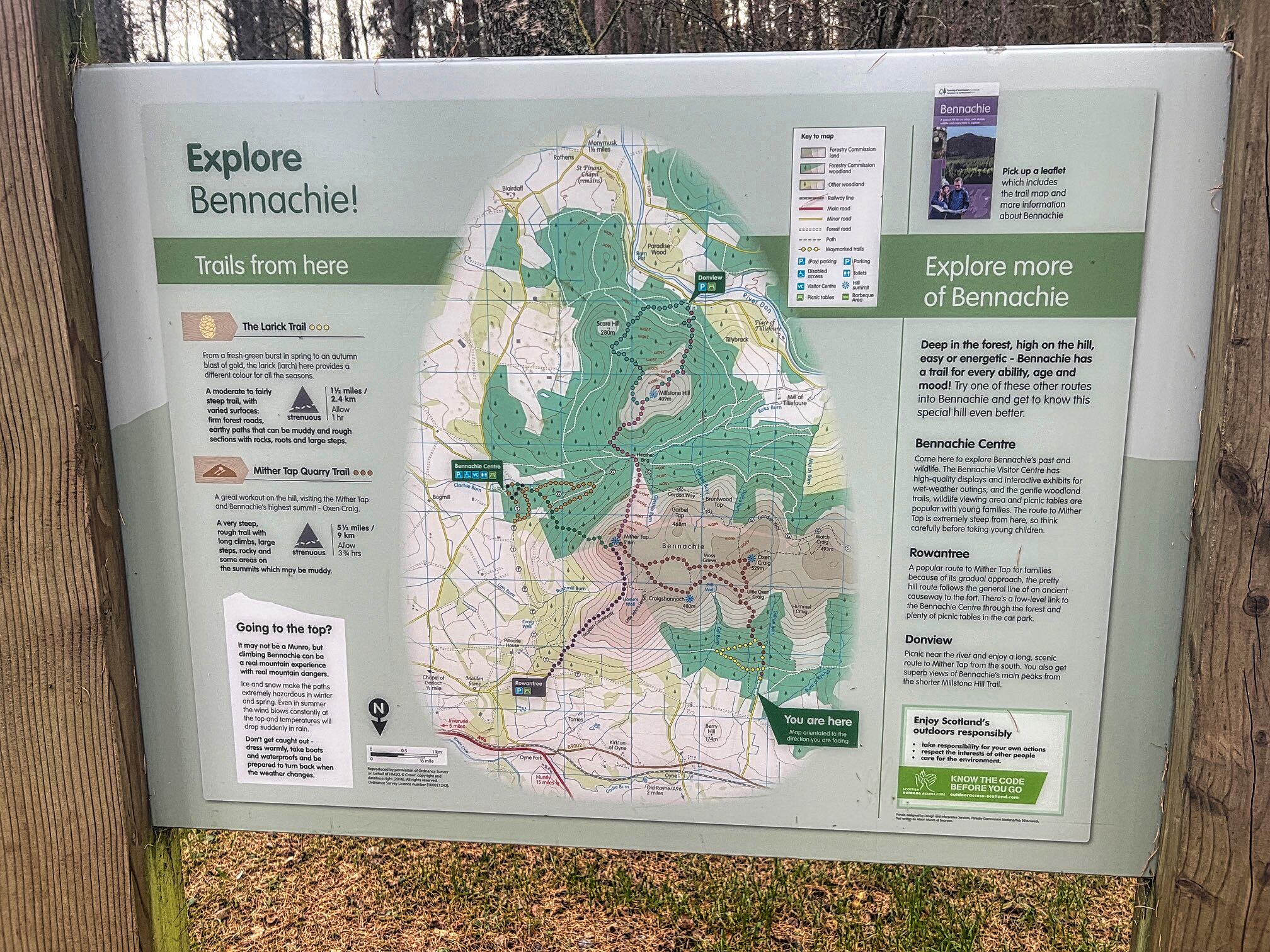
I parked up at the large parking area situated in a pine forest called Back O Bennachie. Well laid out with a toilet block but of course you have to pay. It was a reasonable charge at £2.50 for 3 hours or £3 all day. The all day was the one I needed. Usual problem the machine would not move on from coin only payment to accept a card but luckily I had £2.50 in change in the car. Not really enough but would I be back in time or get fined for 50p?

As I changed the light breeze was gently shaking the tree tops and the pine needles were dropping down slowly, just like snowflakes. By the time I headed off I was covered in orange needles.

As Bennachie is Aberdeen's high ground play area it is popular and well laid out with a myriad of trails. Everything is well signposted so no excuse for getting lost. 


Hopefully that does not get blown down the track

As I climbed through the initial tree section it was another reminder of how much damage Storm Arwen caused a few years back. Despite a lot of tree cutting much more remains to be done to fully open up all the trails around here.

Just before I exited the treeline the wind was much stronger and the trees were swaying and noisy. Out of the relative tree shelter warmer gear was required, a sign of what lay ahead.


The two peaks in the distance are Little Conval & Meikle Conval at Dufftown

I followed a very well constructed dirt path with many stone sections. A short detour took me to the first viewpoint at the quarry, Little Oxen Craig, wind gusts were already very strong.

Oxen Craig

Larger peak on right is Ben Rinnes

Oxen Craig viewfinder looking to Mither Tap

Then back on the track where I kept climbing to Oxen Craig, the true Sub2k. However, the final metres were difficult, the wind was very strong and gusty. When I reached the viewpoint pillar I had to hold onto it to take in the views. As the forecast said excellent long distance views, pity it wasn't a day to enjoy them.

Brief stop before dropping off Oxen and taking the good track to the second hill, Mither Tap, the site of the Pictish fort.

Mither Tap left or right?

When I dropped down the wind had eased and for about 15mins the going was fine. As Mither Tap neared I could see a track on either side. I opted for the left side thinking it was on the sheltered side but not to be. The wind and gusts were far stronger than Oxen, making even normal walking tough going.

Best remains of a Pictish hillfort entrance that I have visited

Apologies but the sign was in very poor condition

As I neared the top and the path petered out. I looked up at the top from this angle, the top about 20 metres higher, but in-between a steep boulder field needed ascending. I was not risking it in these winds. This is a tourist hill so there must be an easier way I muttered to myself. I crabbed over some crappy stuff, trying to keep my balance and found the real ascent track on the other side which went up through the amazing remains of the Iron Age fort. There is a well constructed winding stone stepped staircase to the top which in good conditions would be no problem for most.  But it is exposed and I was very careful as a strong gust meant a dangerous fall.

Sitting beside the trig to avoid getting blown away and try to get a snap without the shakes

On the top of Mither Tap the winds were the strongest of the day. So much so that I crouched my way to the two structures, the trig and the viewpoint. Holding on for dear life I took in the vista. It is truly a superb viewpoint justifying a fortress being built here.

I was even more careful on the descent from the top, some bum sliding to avoid the gusts and with relief reached the big stone shelter. 

A skein of 50+ geese appeared struggling to make ground flying into these winds, find a field to rest I yelled, they ignored me.

Although the paths are well constructed the strong winds were blowing fragments of grit into my eyes, no goggles of course.

Descending from Mither Tap that is Oxen Craig but I was contouring towards the trees

I followed the route to Craigshannoch but passed on another top and contoured the heather to re-join the ascent track and back to the car.

Another objective achieved, just a pity that wind was so strong.

Ascent: 488m

Distance: 9.6km

Time: 2.46

Wildlife: Blue Tit; Pink Footed Geese

Friday, 24 June 2022

Nae deer at all on this short outing.....The Buck (of Cabrach)

Hill: The Buck (Male Deer)

Type: Graham

Height: 721m

Not a lot to be said about this walk as it is as straightforward as they come for a Graham hill.

Weather was mainly blue skies but very windy and still unseasonably chilly.

The first trick was to find the minor road of the B9002 just beyond Lumsden if travelling north.

The second trick was which minor parking area (scrape at side of road) you should pull up at.

The top peeking out from the start
Climbed a broken fence and followed a faint grassy track to meet another fence which I assumed was the one to lead me to the summit.

At this fence, another broken down one, but with barbed wire to negotiate.


After that there is a faint track which at times was very boggy but keeping the fence on my right good progress was made.

Now no dramas, no navigation, no nothing except a steady plod heading for the summit of the Buck.

The going does get better underfoot on the upper slopes.


Hurrah top in sight. A mini tor (rocky outcrop) with a slightly awkward balancing moment to touch the top of the trig.


The views are very pleasant, good but not spectacular. Mile after mile of grouse moors or mile after mile of farmland. There are the odd local hills popping up like the Tap O’Noth which we did last year.

The slightly snow topped Cairngorm hills can just be seen but too far away to have any impact.

One reason to do this climb is from a historical viewpoint. I found the slab with the three interlocking carved fish in Pictish style. It is listed as an ancient monument but to my eye it looked too structured to be historical Pictish art but you never know.

From the top I descended the same way, met another walker and had a chat, a local, before back to the car.

A mornings escape from the good lady and an enjoyable short ramble.

Ascent: 331m

Distance: 3.6km

Time: 1.03

Wildlife: Skylark; Meadow Pipit

Not much to see on the Hill of Fare

Hill: Hill of Fare

Type: Sub2k

Height: 471m

So much for a heat wave, when we started it was light rain with low cloud and it was to get worse as the day went on. So, today it was a small hill outing for the good lady, of course carefully selected with the mandatory good path to the top.

Sat Nav took me an unexpected way and we parked across the road from the normal starting point just north of Torphins.

Ominously at the start a warning sign, no access to the general public as still clearing up from Storm Arwen. No way have we driven here with no back up walk and not going ahead.

The walk heads up the forestry track direct from the quarry, climbing up through commercial forestry plantations.

The good lady complained as the track descended briefly before climbing once more. Evidence all the way of the many trees felled in the storm and how at one point this track would have been impassable, but not today.

We reached the end of the forestry road at the turning area and then followed the obvious track straight ahead.

At this point the rain moved from light to heavy and we soon entered the cloud with the ensuing low visibility. Mrs B not too impressed.


The good path was pleasant enough through the old wood of Scots Pines and then onto the heather moorland. 

Deer Grass
In the gloom the yellow flowers of the gorse bushes were impressively bright as were the bunches of deer grass. There were a couple of muddy places, ok today but the track shows how different it could be after prolonged wet conditions. The gradient eased as the path met with an old track although it looks rarely used.

Though the gloom I spotted what appeared to be a standing stone, the top I knew was off the main track. we easily reached it although I went off into the heather too soon as there is a worn track we used on the backtrack. The top is actually a large stone with some small stones on top so a cairn indeed.

They say there are excellent views but certainly not today. So no hanging about back the same way. The rain got heavier and it got colder. I hate changing in the rain but that's what we had to do.

Oakmoss fungi
Not quite the day we had hoped for but at least the good lady got another Sub2k.

Ascent: 232m

Distance: 7.2

Time: 2.03

Wildlife: Blue Tit; Chaffinch; Meadow Pipit


Saturday, 10 July 2021

A pleasant low level ridge walk.....Pressendye

Hill: Pressendye (Copse of the fire)

Type: Graham

Height: 619m

Just as well I got some walking done last week as the forecast was correct and the weather had changed for the worst with torrential rain predicted for a few days. Plus, the good lady has made an appearance for a couple of days so any walking would have to be a hill with tracks. This area is full of shooting estates so there was a chance of finding one we hadn't done before. A search pulled another rabbit out of the hat, the Graham Pressendye. 

Luckily the weather had relented yesterday and we had a stunning walk right into the heart of Glen Ey, simply majestic, but her hip was sore so hopefully this gentle hill will be fine.

As it turned out when morning broke she was still in pain so some shopping was her therapy. I was given a mornings freedom. Weather forecast was for rain by 1pm so hopefully I would be up and down by then and join her for coffee and cake in Ballater.

A scenic drive to the start point at Tarland, a small place which also hosts a number of MTB trails. The village square was deserted, it felt weird but a very nice village.

Leave the road and cross grass heading for gap

Pleasant green area with blue marker so on the right track

Within a minute takes you back to the road you left, weird!

I followed the Walkhighlands route. Bizarrely it directs you across a grassy area behind some houses, very pleasant, but shortly brings you out on the road you left!!

Chimney Sweeper moth
After that a 40 minute road walk which was pleasant as very little traffic. The verge was full of active birds and butterflies and the views were good so no hardship. I thought I was seeing a common blue butterfly but realised it was a moth, snapped anyway. Delighted to find that it was a Chimney Sweeper, a first for me.

Off the road but don't go to Boultonstone
The walk is a marked trail, there are many here and mine was the blue one. Road section ends after West Davoch farm where I followed the small track signposted 'Boultonstone', it was humid and the flies were circling my face. 

Easy to miss the cut off marker into the field
Into a field which thankfully only contained sheep before going into a wood. The trees were well spaced so not gloomy and now climbing.

Exited the trees and onto the moor still climbing this time through a new plantation which will cause problems at some future stage.

After that it is a long ridge walk firstly reaching Broom Hill. The views are good of a typical east coast hillscape, mostly rolling patchwork hills with the odd biggie sticking out. 

Todays close biggie was the Corbett Morven, memories of a good walk last year.

On the ridge at Broom Hill, Pressendye ahead
A surprising 100m descent before the long climb to Pressendye but all on good tracks through the heather. A large deer fence alongside which I hope not to have to climb.

Big cairn, normal trig, Pressendye summit
Summit reached in 2 hours, where there sits a very large cairn on one side of the small fence and a trig on the other. It is a stand alone hill and although there could be extensive views the haze reduces it today for the southern biggies eg no Lochnagar. 

Looking back to Broom Hill with Morvern behind
I did recognise both The Buck and Cooks Cairn to the north and to the west Morvern along with another conquest from last year Mona Gowan.

The rain clouds were gathering in the distance so time to descend. Firstly straightforward heading for the woods containing the top of Pittendreich (red marker) then still flanking the edge of the woods keep looking out for blue signs, they are not always obvious.

Finally out of the pine woods
Alongside some mature tress a hut is reached and the main track turns left going uphill. That didn't seem right so I kept going onto a bare grassy track. The track was really just a dog walkers section now and I had my doubts but a small blue strip was tacked to a tree so on I went.

Light at the end of the stunning tree tunnel but where are the coos?
I reached another tree lined section, quite picturesque and dramatic. About half way along very fresh coo pats followed by more. Odd as it was big crop fields on either side, waist high barley or whatever, where had the coos come from. More pats and I reached a small wooden bridge with a dirt crossroads. No more coo pats so I can only assume a lone wanderer had escaped from a nearby field.

Ringlet, first of the year
Exited the track onto another minor road which led me back to sleepy Tarland, still not many folk around.

Not a walk that will stick long in the memory except for realising I had dropped my sunglasses somewhere on the descent. Some lucky beggar will get an expensive pair of Bolle's!! Still a pleasant enough outing and good timing as the rain was threatening when I changed at the car. 

Ascent: 603m

Distance: 15.1km

Time: 3.19

Wildlife: Wood pigeons numerous; Meadow Pipit; Tree Sparrow; Buzzard; Wheatear; Red Kite; Red Stag 20+; Ringlet butterfly; Meadow Brown; 

Monday, 22 July 2019

Tap o' Noth a Pictish hill fort and what a view

Hill: Tap o’ Noth
Category: Sub2k
Height: 563m
When the good lady rose from her slumbers I told her that it was her lucky day, we were going to visit the remains of the second highest hill fort in Scotland. Not sure she quite processed the lucky bit so I left her to digest the information and went for a cracking bike ride to Linn’ O Dee, stunning scenery.
Beautiful early morning Strathdee
The reflection time was positive. After brekkie we set off for a gloriously scenic drive, which perked her up, apart from the two squished red squirrels on the road, one of her favourite species. Still, we arrived at the less than daunting hill, the Tap o’ Noth car park almost full, a tourist trap? To be fair it only holds about 8 cars and the motor home did for most of that.
New track at start
A nice new looking sandy track took us uphill to the deer fence where it became a grassy track that wound its way to the next fence.
Pleasant grassy section
 This grassy section a riot of colour and butterflies and moths aplenty. A new plant to me yellow monkey flower (according to said good lady) a highlight.
Unless you want a cross country circuit turn right here and head to the gate at the deer fence.
People on top of Tap

he top does not look far away, we can even see people moving about, not sure someone else agrees!!
Clearer view of the TAp
Now out onto the moorland where the track is more rocky but is still in great condition and thankfully for the good lady it continued to meander round the hill. 
Getting there
Views were excellent, the scarred track of Ben Rinnes prominent.
As we got towards the top both Lochnagar and Mount Keen came into view. 
There is an excellent information map to spend some time at before heading over the top into the bowl of the fort and then onto the trig. 
Trig with Ben Rinnes behind
Certainly not the biggest hill but in terms of location it is the biggest around. With a fantastic 360 degree perspective, no wonder it was the location for a fort.
It is fantastic to stand here and let the mind roam. Built by the Picts, the huge walls vitrified (burnt), probably deliberately by them to make the fort even stronger. Mind-boggling when you read the notice board at the car park, this is our history. 
Inside the fort looking to Aberdeen
Spotted a large very orange butterfly which on examining the snaps later turned out to be a ‘small’ tortoiseshell. If that’s small the extinct large version would be mighty impressive.
From the top the Cromarty coast and Sutherland are clear. The stand out peak on Sutherland, surely Ben Hope. If so there cannot be many places where you can see the most northerly and the most easterly Munros. Another reason why the good lady should be so lucky. She always enjoys it when she gets to the tops and soaks in the views.
Superb shot bringing the fort boundaries to life
The rain threatened and skirted us but thankfully we stayed dry.
A gentle descent back the same way to the car park with the promise of coffee and cake in Ballater.
A cracking MTB ride and a good wee walk with fabulous views, a good day to be alive.
I wonder how lucky she will be tomorrow?

Wildlife: Kestrel; Buzzard; Linnet; Meadow pipit; Meadow brown; Six spot Burnet moth; Small tortoiseshell; Ringlet.
Time: 1.47h
Ascent: 295m
Distance: 5.01k