Showing posts with label Calmac. Show all posts

Wednesday, 16 September 2026

Warm, blue skies, great views and lots of bitey things.....Meall nan Damh (Arran)

Hill: Meall nan Damh (Hill of deer or ox)

Type: Sub2k

Height: 570m


It has been absolutely yonks since I had a trip to Arran so I was all excited for this ramble. An early start to get to Ardrossan for the 1st CalMac ferry and of course a black pudding and fried egg roll to set me up. After that on deck where I spotted porpoise so an excellent start to the day.

Jenny was waiting with the car so no messing about with buses today. A scenic drive over The String to the west of the island no hardship at all.


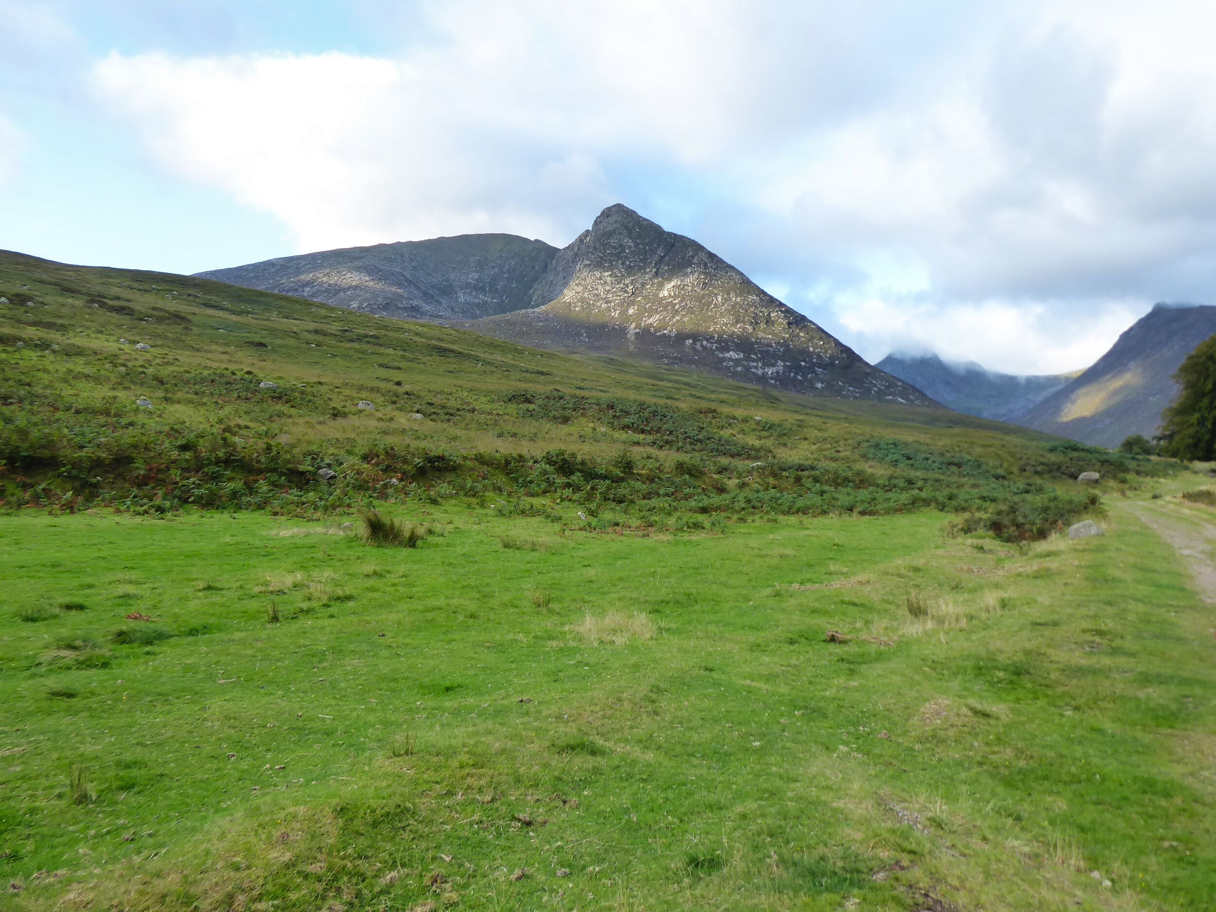
1st sighting of todays objective, not through the bracken thank god

Parked up at Thundergay it was already hot when we made the steady climb up to the popular Coire Fhionn Lochan. It is a well maintained track but the lower sections go through bracken flanked sections but just enough room to get through.

Out on the open moor and the views are opening up over the water to Argyll and north as well as inland to our destination.

Closer view ascending far left (Meall nan Damh) and descending via lump on the right (Meall Bhig). More water cascading the falls than I expected.


Our target is in view over to our left but our immediate ramble is heading towards imposing steep flanks of the Corrie. The only downside is that the flying insects are out in force particularly the clegs constantly warning each other to brush them off clothing. As it turned out when finished I had 5 bites through my clothing and none on open skin, ambush predators.

Stunning Coire Fhionn Lochan

The lochan suddenly appears and what a beautiful picturesque spot it is with a sandy beach at each end, other people already here. A good place to refresh the feet. Tadpoles swimming around the edges.

But we had a hill to bag so off we went up the eroded on/off track to the bealach to the right of Meall Bhig, a large cairn the obvious target. The cairn provided an excellent viewpoint back to the lochan. From here there is a grassy slope that goes above the corrie eventually leading to Beinn Bhreac.

Doesn't look too bad from here but rough ground for a wee while

But we were going in the opposite direction which was now going to be fully off track. I think Jenny was a little apprehensive looking at the slopes of Meall nan Damh. It is only 150 metres of steep ascent but without any obvious path all the grassy rocky crags it is a little imposing. As I said to Jenny ‘welcome to my world’, not the easy tracks of the Munro baggers.

We decided that heading to a small unmarked lochan in the direction of Glen Catacol and come of the flanks was the best option.

I can imagine that at different times this could be a very boggy section but today apart from the biting things it was fine. Small common frogs were all around.


It was here that a large flying bird caught our eye, obviously an eagle what a bonus. It was never close but stayed in sight for a couple of minutes. Looking at the poor snaps later it looked more like a White Tailed Eagle, either way a bonus sighting.

A bit steeper than it looked from back there

Witches Step

I used that track to do the Sub2k of Sail Chalmadale (see blog)


The climb was short but steep. It was just a case of short sections, stopping and trying to stick to grassy sections, avoiding the heather and hidden hazards as much as possible. Also lots of opportunities to stop and take in the views.


After about 100m the gradient eased and soon after it was a lovely stroll to the summit. The summit cairn surprisingly appearing not too far away, a welcome sight.

As hoped this was a stand alone hill that provided outstanding 360 degree views. All of Arrans big hills could be seen with some great jagged profiles. Looking north the arrochar Alps and the bulk of Ben Lomond. In the hazy distance Ben more.

Nearer by views into glen Catacol up to Loch Tanna, Arrans largest inland water.

And over the water to Argyll and further on the Paps of Jura. Very impressive and time to enjoy a snack and take it all in.

The hill is named after deer or ox but I suspect deer. On the top there were fresh droppings.

To make it a circular we headed down to a larger unmarked lochan. Not quite as steep as the ascent but care still required as many hidden holes. Skirting the lochan it was a bit boggier as we headed up the side of Meall Bhig when a hind appeared on the skyline being followed by possibly the smallest calf I have seen, possibly only days old. But as quick as the appeared they were gone but a lovely sight.


We headed over the top of Meall Bhig and descended back to the lochan where some wild swimmers had been ‘enjoying’ the cold waters.

Paps of Jura much clearer on the descent

A leisurely walk back to the car. No time issues to worry about catching a bus. But after all that the Ferry was late!!

Dark Green Fritallary


A cracking ramble but definitely a hill to leave for a good viewing day. Probably better as a winter/spring ramble to avoid all those biting beasties.

Ascent: 672m

Distance: 10.07km

Time: 5.22

Wildlife: Golden Eagle; White tailed Eagle; Red deer; Raven; Common frog; Fritillary; Orange tip; Small White; Meadow Pipit; Porpoise

Friday, 26 May 2023

Arran's wild west.....Sail Chalmadale

 Hill: Sail Chalmadale

Type: Sub2k

Height: 480m


Sail Chalmadale is small Arran hill that I had been meaning to get around to and an opportunity arose when I spotted it on the Arran Mountain Festival programme. This was way back in January and I had totally forgotten about it until it popped up as a calendar reminder the day before I was due to go on it. Wow, quick decision time.

Forecast looked good and the ferry was operational so yes a day trip was on.

On the quiet 7am ferry in good time for my brekkie roll and time to catch up on my sleep as we sailed.

As the group gathered my fears about the ability of a couple of the group to maintain the required pace were rising. More about that as this ramble evolves.

The walk is a rough but fine route on the west of Arran starting at Catacol and finishing at Dougrie, ascending Sail Chamadale en route.

Start of walk 'eagle crags' on left but none spotted

Beinn Tarsuinn (the smaller one) directly ahead
The walk begins by heading up Glen Catacol which I recognised as the final section of my 3 Glens walk. The water on the Abhainn Mor was very low but crystal clear, I would drink out of that if required. Sand Martins flew in and out of an eroded sandy riverbank and a lone sand piper called and flew away near by. Not long before the Cuckoos began calling, we reckoned 2 on our right and at least one on the left. And superbly a female on our left started calling and we then spotted a pair flying, great start. Although the walk started with many heavy grey clouds it improved and we had no rain.

The track at this point is narrow, alternatively boggy and stony.

Heading up the glen Ben Bhreac slopes on left

Example of track with enclosure ahead

Uniquie Arran Whitebeam tree
At a ford the left turn becomes Gleann Diomhan but we crossed the burn and continued south up Glen Catacol, starting to be hemmed in on our right by the flanks of Beinn Bhreac. There are a few fenced off plantations presumably protecting the rare to Arran Whitebeam tree. These are restricted to the northern part of the island and are numbered in their hundreds.

Waterslide

The track was now rising and the broad waterfall bringing down the Allt nan Calman was a spectacular rolling slab of stone. A cairn is reached at point 336m and here the terrain changes. The walk leaders had been concerned about the slow pace of the group, the most concern being me getting back for the last ferry. The slower ones were offered the opportunity to go back at this point with a guide but nope they wanted to continue. The guides knew I was capable so offered me the option of going solo, something I said I might take up later.

Enter the bog of Loch Tanna


From L-R Castail Abhail, Cir Mhor, A Chrois, Beinn Tarsuinn & Beinn Nuis

Cnoc Breac on left Sail Chalmadale top on right
We were now walking on the west side of Loch Tanna, a really remote spot but scenic on a day like this, not much chance of meeting anyone else out here. It was really wet, I suppose it never dries out. So much so we were heading higher to get better walking which for the most part was good.

However one of the tail enders slipped on the muddy slopes and was well covered in gloop. Not hurt and I was not alone in having a smirk but then it took another 15 minutes before they could get going again.

Now I was getting more concerned. The pick up was for 5pm but at our rate of progress the group were going to need to put that back, problem at this stage, no phone signal, oh dear. The views over the eastern hills were fantastic as the light kept changing with passing clouds.

Chalmadale from Cnoc
Down into peat hag terrain then up the boulder strewn nose of Cnoc Breac. By this time the stragglers were well behind and the guide was just as concerned as I was and luckily we got a signal. Decision made I was going solo to try and meet the pick up at 5 where they would wait 15 minutes or it had to be a pick up with the main group, no pressure then. It was now 3.30.

A short descent and reascent and I was on top of Sail Chalmadale. A quick look round then along the ridge knowing there were crags on the nose so decision time when I reached them about which flank to take. A rugged little mountain but as always with a stand alone hill superb views.

View from cairn on Sail

Loch Sail in snap along with track to Dougarie
Standing at the top I could see Loch Sail Chalmadale where I knew and atv track would be picked up. It looked a long way down.

I decided to turn right/west, down the steep grassy rakes, adjusting my route as required.

With relief I was down but the terrain between me and the loch might have been flattish but it was the worst of the walking. Tussocks abounded but they were islands in marshy terrain so the going was slower than I wanted. Further relief when I found the atv track but it was so slippery that it was easier walking to the sides. Still pace picked up.

Looking back from Sail loch to Sail hill
I could now see the Iorsa Water and its hard packed track which would lead me to Dougarie. The bracken here was the highest I have seen this year, will soon be obscuring the track. Another ford to cross, no stepping stones, this could be interesting with higher water levels. 

Looking back along Iorsa Water
Just the river section left which was scenic, maybe just my relief at being off the hill.

The land owner has put in a separate track in for walkers to keep them away from his house but it is still a decent track.

At 4.40 I reached the water and 10 minutes later my transport arrived. So good that I even made the relief catamaran rather than the last boat. On the ferry I got a text from the guide, around 6.40 pm, saying that was them at the parking area. Getting to the last ferry would have been extremely tight so I made the right call.

As a ramble I thoroughly recommend it if you want to see Arran from a different perspective and want the feeling of real isolation. Naismith rule suggested 4 hours 30 and 6 hours would be more than ample. I have finally learned my lesson re group walking with strangers lol.

Ascent: 552m

Distance: 15.5km

Time: 6.45

Wildlife: Stonechat; Cuckoo; Sand piper; Golden plover; Sand Martin; Meadow Pipit; Skylark; Raven,

Sunday, 30 October 2022

A hot day on Arran.....Cir Mhor

 Hill: Cir Mhor (The great comb)

Type: Corbett

Height: 798m

Another day to get excited about. It was to be my 1st trip to Arran since Covid, almost 3 years has passed, unbelievable. But maybe I wasn't as excited when my alarm went off as I was going for the first ferry. But I sure was by the time I was on board and had my traditional CalMac breakfast roll.

The objective today was Cir Mhor, known as the Matterhorn of Arran, no arguments from me.

We were going through Glen Rosa but there are no buses to the String Road that tie up with this ferry. The other bus driver said she would stop as close as she could but she forgot about us, thankfully not much of an overshoot so a short walk back.

It was a hot morning even this early.


Anticipation builds as the hills are spotted ahead as we enter Glen Rosa. The walk through Glen Rosa was different. The foliage was long and so overgrown the path could not be seen at times. Lots of ski style shuffling feeling for obstacles. But the worse was the insect life. Lots of minor bites and a couple of cleg ones. One of them was 3 bites through my shirt on my back right at my rucksack. At first I thought it was just a twisted strap but nope, real bites.

So it was relief to reach the junction and start the climb proper.


That's a proper pointed peak of a mountain

Cir Mhor was looking magnificent, a grey fortress with a stunning peak against a clear blue sky what a sight.

When we reached the corrie a cooling breeze was very welcome, I had been feeling it in that heat.

Looking over to Loch Tanna, Beinn bharrain & Meall nan Damh

Up the short zig zag track and the north and west of Arran is your magnificent vista.

Lost the correct track going through the boulders and thought we had found it but it was heading for An Caisteal. So a direct line up through the grass and boulders and came across the track.


It is an interesting climb and the latter section requires hands on minor scrambling before the top is reached.

The ridge to 3 Beinns

Glen Sannox and Witches Step on left

Goatfell Glen rosa side

At the top is a small area for about 4 people to sit and take in the view. The views are amazing looking over to the Witches Step. Glen Sannox far below with the blue waters of the Firth beyond. Goatfell of course dominates and looking down Glen Rosa both the Holy Isle and Ailsa Craig can be seen in the haze.

Glen Rosa with Ho;y Isle in background

One final look back at a stunning mountain

We followed the same route back. Grateful that the breeze was now lower which made the walk through Glen Rosa much more pleasant. It is still a long haul but the beasties were hiding.

Common Darter

Dark Green Fritillary
One of the frustrations is the non buses to meet the extra summer sailings a disgrace for a tourist island. So the long walk back to Brodick and we missed the ferry by 10 minutes. Time to hang about and take in the scenery.

A cracking walk on a beautiful day.


Ascent: 878m

Distance: 20.5

Time: 7.01

Wildlife: Common Darter; Meadow Pipit; Scotch Argus; Dark Green Fritillary;

Sunday, 18 September 2022

Goatfell but not the tourist track, the scary scramble version.

 Hill: Goatfell via North Goatfell

Type: Corbett

Height: 874m

Another CalMac crossing, I'm becoming a regular these days, this time a sailing to Arran. A pleasant crossing soon passed after a CalMac brekkie roll and good company.

Glen Sannox with Cioch na h-Oighe on the left

Crossed the burn before The Saddle looking back down Glen Sannox
The initial plan for today's walk was to ascend Goatfell from Sannox via the Cioch na h-Oighe. But the best laid plans and all that. The gusting winds put paid to that, potentially too dangerous on the ridge.

The chute
The result was a longer walk up the beautiful Glen Sannox to the first obstacle of the day, The chute that leads to the Saddle. The blue skies and tranquil surroundings made us blaze about what lay ahead. Not tackling the ridge might have seemed the easier option but it was far from that. A few scary moments lay ahead.

The Saddle has a steep chute which is normally challenging but straightforward. Today the rock was wet and slippyery. One person got up it but I could not get a grip with either hands or feet so elected to retreat. The group now ascended via a section nearby which was slightly drier but still a technical challenge for most of the group. Slow progress, helping hands and a few elevated heart rates but we got there. With relief a short break was taken on the top of the Saddle.

Jagged ridge ahead

Scrambling starts again. Goatfell on the right

Rugged landscape. The Witches Step gash on the right
Next obstacle was the climb to North Goatfell. A good track took us most of the way up before the intimidating final section of what now looked like a proper Alpine ridge.

Another steep chute with big drops caused more high stress. We had to keep a distance in case the person in front slipped/fell taking others down as well. Another wet rock section with minimal foot and hand holds was a challenge for most although a couple of the group made it look easy. Easy it was not.

Cir Mhor the spike behind with The Saddle the flatter ground to the right

View down Glen rosa. Is the rock a snake or crocodile?
But we made it to North Goatfell with outstanding views to savour.

Sadly, this was not our top. We now had another ridge with more potentially tricky scrambling and exposure. Even getting to the start of this involved hairy descents over steep slippy rocks, bum sliding at times on these descents.

A debate ensued and the party split with about half, including me, taking the bypass route.

Bypass route

North Goatfell's ridge to Goatfell

Some of the group on top of the rocky scramble
A narrow trail with some exposed minor scrambling before we finally reached Goatfell itself. Looking back the other group were still some ways back. Best decision for a long time to go bypass lol.


The descent
A scenic lunch at the top before making the long, long descent back via the tourist track to Brodick. Most had a well-deserved ice cream, a few a beer.

My face was skelped with a combination of the bright day and the high winds which meant I never felt the sunburn until too late. Plenty of Aloe Vera gel will be applied.

This was a stunning but tough day. Most of the group were experienced walkers but most were feeling significant leg muscle tiredness. A cracking day but I can live without the higher stress levels for a midweek walk.

Ascent: 939m

Distance: 15.7km

Time: 7.24

Wildlife: Raven; Common Darter; Common Blue Dragonfly;