Sunday 18 August 2024

More bog trotting but well worth it.....Meall Coire an Lochan

Hill: Meall Coire an Lochain

Type: Sub2k

Height: 517m


I was exploring Walkhighlands for a short half day walk and came up with two options. One involved a very steep ascent and from a visual drive past lots of bracken and with the amount of recent rain a potentially dangerous water crossing. The other was a pathless boggy moorland walk to the middle of nowhere which no doubt would be very boggy. Of course I could just stay in bed!

What swung my decision was this walk had only 34 people having bagged it on Walkhighlands, so I had to find out if it was really that bad.

This is the highest of the Cromalt Hills, I bet you had never heard of them either.

I started at the same car park that I used for Cul Beag but heading in the opposite direction. First issue was that the connection between my PC and GPS last night must have not been secure as the walk did not show on the GPS. The visibility was fine and I did have map & compass so walk was on.


The hill starts with a so called ATV track that disappears almost immediately and immediately it was wet and gloopy.


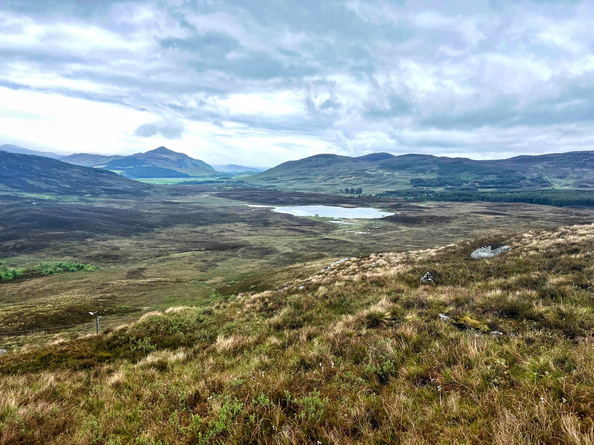
That is the ridge in the distance, I was going from right to left

The track rises to the right of the communication mast and once crested there is a view of the moor ahead. A very faint ATV track goes down into the longer grassy wetland before disappearing a lot quicker than I expected. There was a small rise ahead and a group of 8 red deer hinds initially spooked but let me get very close before running off.

Over the top and more of the same. I spotted a stag on a ridge body twisted as it looked at me but I was too far away to be an issue for him. It was an interesting ramble as I must have came across over 30 deer in small groups.


Not even a faint track from now on

I had a visual on the subsidiary top of Meall nan Dearcag Mor which I would ascend before walking the ridge to Meall Coire an Lochan thus giving me a circular ramble. From this location it also seemed the most direct route.


A good shot of the terrain. I was going to head up the grassy section on the right

The whole walk was indeed pathless. It was mostly wet and boggy with much time spent trying to avoid the very large peat hags, the many mapped and unmapped lochans, much toing and froing. The further I went the more I realised I was in a real wilderness, definitely not recommended in poor visibility. I know it is not to everyone's taste but at times like this I really enjoy the solitude, the feeling that you are just a mere pin prick in this vast landscape. There is also the slight edge that if something went wrong help is not going to be other walkers coming along. Still that edge is my adrenalin rush so it is to be embraced not feared.


Ben Mor Coigath on right and I think An Teallach in distance

When I closed in on my final ascent I came across a very dilapidated old iron fence line, not marked on my map. It could be followed if going directly to the main top but not for me today as I was going straight up the wet grassy face. About 70m of fairly straightforward ascent although the grass/heather was very wet and slippy along with the gradient at times between 40-60% so hands used as well.

On the top I got the first opportunity to have a good look around and take in the magnificent views and rugged landscape.


True summit is the high point in the middle

A 15 minute walk along the fairly level grassy ridge would take me to the real summit although from an eye perspective there is not a lot between the tops although the 517m definitely higher. Along the ridge where a pair of Golden Plovers were trying their hardest to distract me from wherever their nest was.


Great views of Cul Beag, Cul Mor & Suilven

Five minutes further on I reached the small cairn with an interesting  pipe/pole marked the summit.


Looking to the boulder slopes of Ben More Assynt, Ben Klibreck pointed one on the right

Looking around I now knew that despite the rough walking the views were one of the best that I have had in this area. Up until now I thought Breabag was the overall best vista but this hill stands so alone that much ore can be seen. Not as high of course but what a 360deg view. Just look at its location on the map and you will see what I mean, quite superb.


Descent was via the strip between the two lochans

Looking over Loch Odhar


From up here the peat bogs were numerous as were the large and small lochs/lochans. I made a steep descent heading for Loch a Phris to then traverse between it and Loch Odhar. Probably slightly easier walking than the in route. But on the in route when I looked back I could usually see the mast as my reference point. But on the return it was hidden until the last section.

Overall it far exceeded my expectations. Yes the ground was rough but with no visibility issues it is straightforward enough. But those views wow, more walkers need to appreciate it. It deserves its place along with all the other Assynt hills.

Ascent: 413m

Distance: 8km

Time: 3.19

Wildlife: Red Deer; Meadow Pipit; Golden Plover; Common Frog;

A hill that lives up to it's name.....Meall Glas

Hill: Meall Glas (Greenish/Grey hill)

Type: Munro

Height: 959m


I really don't have a good reason as to why I had not ticked this one off as I have stayed in the area so often, but with the good weather forecast, today was the day. It is normally combined with Sgiath Cuill which as a double act has a horrible reputation, once done never again sort of thing. But I have plans for a bike/hike for Sgiath on another day so this just a solo.

I left home very early as parking can be limited but no such issues as only 2 other cars in situ when I arrived at Auchnessan in Glen Dochart. It was already hot and the midges were buzzing about but not biting.


Meall Glas on left Sgiath Cuill on right

I caught up with a guy who said he was doing both and had a brief chat. I am no athlete but I was seriously concerned about his ability to do both in this heat and the terrain. To say he was overweight and slow would be understatement but each to their own. He ushered me to go ahead as he was already struggling, good luck I thought, never saw him again.


The bracken worsens as you go higher

I remembered the initial ascent when I did the Corbett a couple of years back, pleasant enough with the trees and burn, steep enough to get everything going but also today the bracken was sprouting, I reckon in a few weeks time the growth will cover over the trail resulting in a not so pleasant bracken bash.

Further up I also recognised the spot where I cut off to tackle the Corbett but today I stayed on the main trail, what little there was of that at times.


Getting closer

Good view of full ridge

The middle section is on and off track, trekking through peat hags and bogs but at least the good visibility meant you could keep refocusing on the direct line. Certainly it is a large area particularly noticeable when looking from above on the descent. The breeze up here was stronger so less flying things. 


Beinn Challum

As I climbed the views were improving, peaks were starting to appear all around.

The last section is the most interesting and also by far the steepest but with no real issues. The ascent is mainly grassy, dotted with boulders but with the clear visibility there was no issues avoiding the dangerous crags. Actually these would be more dangerous on the descent particularly in bad weather. To be fair to its name the hill was very green with the grey crags and boulders for contrast.

I took a direct route of ascent and the steepness took me by surprise a couple of times. Looking at the graph some 40-50% sections of gradient, no wonder hands were being used. No difficulty just using those hands to balance on the steep slopes when required.


Easy gradient to the cairn

Finally I reached the top of the steep grassy section which then left me with a pleasant upward stroll to the cairn. 


The views were magnificent, indeed because of the unseasonable clear air distant hills that should have been hazy were picked out. Take your pick from the distant Ben Nevis, Glencoe hills, all the local Munros and many, many more.


The Corbett of Beinn nan Imirean

Heading down Ben More behind

As inevitably happens on the descent I found a track that would have made the steep grassy slopes a lot easier but that's life. Looking down on the peat hagged terrain it looked both quite spectacular and inhospitable.

I was taking my time and enjoying the views, something that seems to have become rarer, too many boulder/scree descents.

I met and chatted to a couple of other walkers but this is a wide landscape and people could be easily around but missed.


Handsome Cockerel

Spent a few minutes looking for trout in the shallow water

Some more bog hopping then back the lower slopes and the real heat. Amazing that the forecast for tomorrow is cloud and rain and snow predicted midweek for the Northern tops, unreal.

Still this did the job, a stress free good weather ramble. At the car the midgies were out in force, a sign of the year to come!

Ascent: 872m

Distance: 11.9km

Time: 5,2

Wildlife: Red Grouse; Buzzard; Common Frog; Meadow Pipit; Raven; Orange tip (m+f)

Thursday 8 August 2024

A rough wee ramble.....Creag na Doire Dubhie

Hill: Creag na Doire Dubhie

Type: Sub2k

Height: 571m


My intention had been to get a higher hill on my to-do list out of the way today but the weather forecast had turned brutal for this time of the year. Instead of the hoped for blue skies and higher temperatures the reality was the opposite. A months worth of rain was predicted bringing with it flash flooding, this was not helpful at all as one of my optional Munros had a river crossing, would I get across or even worse would I get back over on the descent? Throw in cloud level at around 600m with very poor visibility on the upper hill plus the bad weather included 40-50mph gusts up top, rethink required.

However, I did have a back, this Sub2k which I had intended to do tomorrow on my way home.


View of summit from parking area

I had this slotted in for completing last month but weather snubbed that again. I was within 5 minutes of the parking area with the rain at its heaviest of the morning. I was thinking that I was going to be sitting in the car for a while but just as I reversed into the spot the rain went off, finally a good omen perhaps.

I was starting at the normal point of the Halfway house bridge, room for about 4 cars if parked nicely.


Headed down the track beside the burn and found my first obstacle of the expected burn to cross but not the fallen tree over the track, easily bypassed.

Soon reached the end of the trees and the gate onto the open moorland where the small ridge with the large cairn was clearly in view.


Left to Loch Caoldair but right for me

There was a good track until I reached a Y junction, slightly beyond Loch Glas-choire which lies on your right.


Looking back to Loch Glas-choire

Took the now narrow right fork which although it does not look much it does continue up to the corner of the deer fence.


There was a faint ATV track going over the hump in front of me but I elected to follow the fence to its next junction. Some deer tracks but mainly heather bashing, poorer walking, sometimes on a steep incline but I did make it to the fence corner where the gate was lying on the ground, not me guv!


All off route from now on through the boggy ground, quite deep heather growth and lots of new growth bracken breaking through. As always pick your own line and keep climbing. And as always there were a few minor false tops before the flat area is reached with the large cairn nearby.


View North to Creag Dubh

Although there had been a few spots of rain I was dry and despite the low clouds and the greyness the views were not too bad at all. An hour to the top which was what I anticipated.


Rough ground ahead

From here I could see another track on the other side of the loch. The ground between me and a small very bright green patch at the start of the track looked rather rough. I assumed the green to be sphagnum moss. As I had plenty of time I decided to make it a circular route.


Green patch with track beyond

I took a line to aim for but it turned out to be far worse than the ascent route. Although the contours looked similar it felt much steeper and the terrain was just awful. Very steep wet ground, laced with heather and boulders with a bottom layer of bracken. In a months time when that bracken has grown forget it. It was only 15mins of descent but not at all pleasant.


Finally I was on the flatter heather where I headed towards the deer fence intending to follow it round to the track. Glad I did head towards it as I stumbled along a track which took me all the way to green area better than following the deer fence. The track was odd being there, it was as if a small digger had dragged its bucket along behind it clearing a strip between the heather. Whatever the reason I was glad of it, saved a lot of heather bashing.

Reached the green bit which was not moss but a small perfect fertile grassy area, looking around everything else is moorland, why did this patch develop, nature can be wonderful.

The track I wanted was only about 50m away but the deer fence was now a double one, why? I thought I was going to have to climb but I wandered down a bit and found an old iron gate, job done.

Then it was just a case of following the winding track back to the road keeping an eye out as there were big droppings, coos around, but never saw them.


Common Heath

A short road walk to find another car parked up, not the only person with a plan B today.

Another new hill bagged, a decent bit of dry fresh air, so not entirely a wasted trip. A fine wee hill with the advantage of a high start, perfect.

Ascent: 309m

Distance: 6.49

Time: 2.15

Wildlife: Meadow Pipit; Willow Warbler: Chaffinch; Stonechat; Barnacle Geese; Common Heath,

Tuesday 6 August 2024

A delightful walk.....Sandgreen Bay

 Walk: Gatehouse of Fleet - Sandgreen Bay


The good lady was at an arty workshop so I took advantage of the good weather to do this circular walk. No hills involved but I absolutely loved it. I did the walk clockwise but either way fine. 

Stunning woodland pity you cannot hear the non stop singing of the spring birds

The ruined Temple

My ramble started by going through the Caley Palace woods which were alive with singing birds, a magical place today.

Interesting water level board at the side of the road! Any information on why this is here would be welcomed.

The old church ruins at Girthon. This structure was built on top of another church estimated first established in the 13th century.

There is some road walking but it is so devoid of traffic that the feeling of peaceful countryside dominated.


Him

or Him?

Then cutting along to Sandgreen Bay where I encountered the testosterone bulls. I was far away wondering what this low level rumbling noise was. Then I spotted five bulls in the field and the noise was coming from two of them who were having an alpha male encounter. Watched for around 10 minutes, the body language of the two was fascinating as was the body behavior of the other three bulls who were clearly agitated.

A beautiful bay with the D&G coast a standout. The bay has a large caravan park surrounding it and as you would expect water sports dominate. As I walked through the caravan park boats, canoes and other sea sport items were plentiful.


Turned around and headed back into the forest with outstanding scenery including the stunning bluebell woods and running water.

So warm it was great. If your in the area I strongly recommend this ramble.

After all that energy expended it is time for a pint sitting outdoors at the Masonic Arms in the spring sunshine, bliss.  

Ascent: 93m

Distance: 14.42km

Time: 4 hours