Showing posts with label Dalwhinnie. Show all posts

Thursday, 8 August 2024

A rough wee ramble.....Creag na Doire Dubhie

Hill: Creag na Doire Dubhie

Type: Sub2k

Height: 571m


My intention had been to get a higher hill on my to-do list out of the way today but the weather forecast had turned brutal for this time of the year. Instead of the hoped for blue skies and higher temperatures the reality was the opposite. A months worth of rain was predicted bringing with it flash flooding, this was not helpful at all as one of my optional Munros had a river crossing, would I get across or even worse would I get back over on the descent? Throw in cloud level at around 600m with very poor visibility on the upper hill plus the bad weather included 40-50mph gusts up top, rethink required.

However, I did have a back, this Sub2k which I had intended to do tomorrow on my way home.


View of summit from parking area

I had this slotted in for completing last month but weather snubbed that again. I was within 5 minutes of the parking area with the rain at its heaviest of the morning. I was thinking that I was going to be sitting in the car for a while but just as I reversed into the spot the rain went off, finally a good omen perhaps.

I was starting at the normal point of the Halfway house bridge, room for about 4 cars if parked nicely.


Headed down the track beside the burn and found my first obstacle of the expected burn to cross but not the fallen tree over the track, easily bypassed.

Soon reached the end of the trees and the gate onto the open moorland where the small ridge with the large cairn was clearly in view.


Left to Loch Caoldair but right for me

There was a good track until I reached a Y junction, slightly beyond Loch Glas-choire which lies on your right.


Looking back to Loch Glas-choire

Took the now narrow right fork which although it does not look much it does continue up to the corner of the deer fence.


There was a faint ATV track going over the hump in front of me but I elected to follow the fence to its next junction. Some deer tracks but mainly heather bashing, poorer walking, sometimes on a steep incline but I did make it to the fence corner where the gate was lying on the ground, not me guv!


All off route from now on through the boggy ground, quite deep heather growth and lots of new growth bracken breaking through. As always pick your own line and keep climbing. And as always there were a few minor false tops before the flat area is reached with the large cairn nearby.


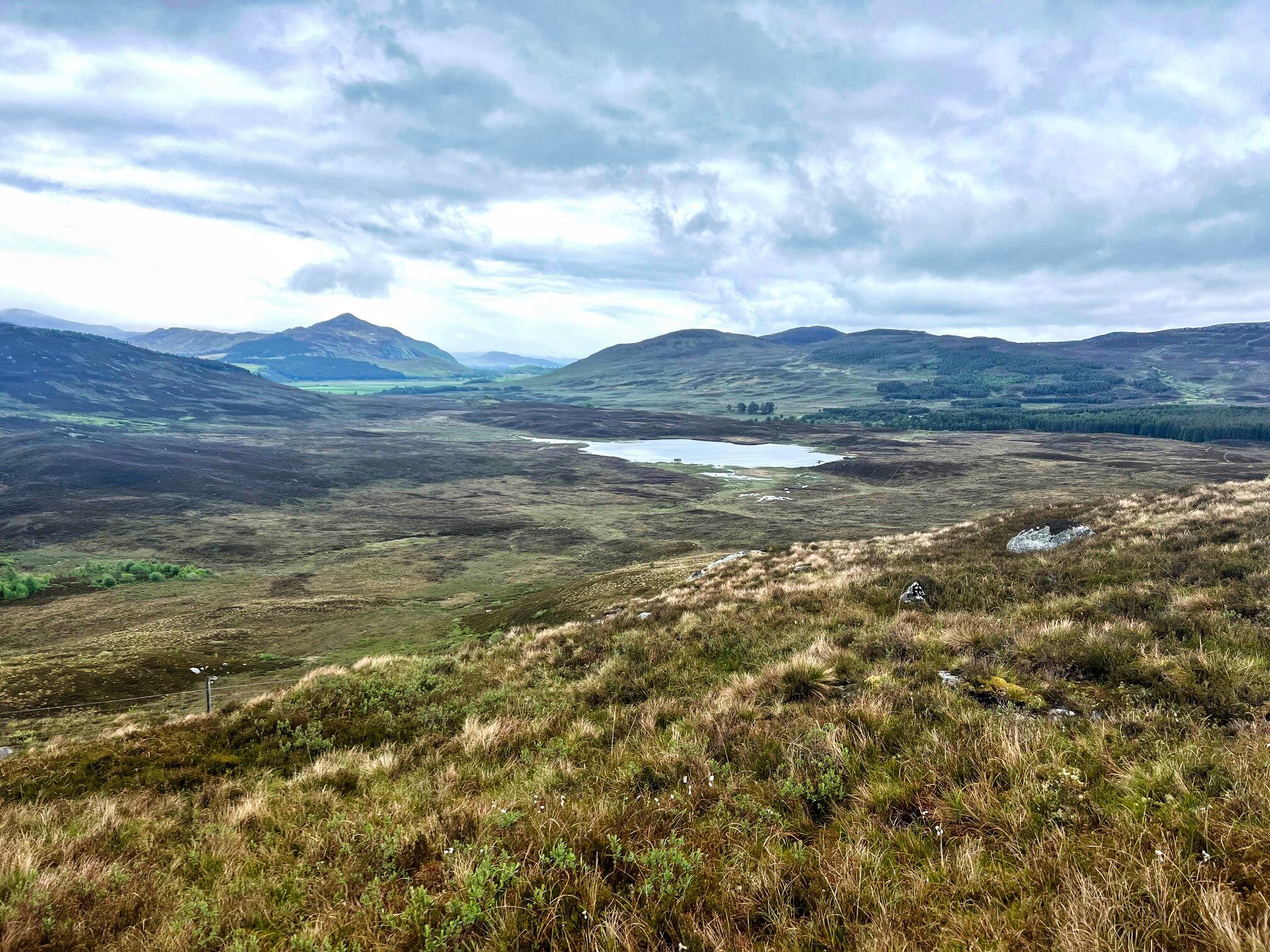
View North to Creag Dubh

Although there had been a few spots of rain I was dry and despite the low clouds and the greyness the views were not too bad at all. An hour to the top which was what I anticipated.


Rough ground ahead

From here I could see another track on the other side of the loch. The ground between me and a small very bright green patch at the start of the track looked rather rough. I assumed the green to be sphagnum moss. As I had plenty of time I decided to make it a circular route.


Green patch with track beyond

I took a line to aim for but it turned out to be far worse than the ascent route. Although the contours looked similar it felt much steeper and the terrain was just awful. Very steep wet ground, laced with heather and boulders with a bottom layer of bracken. In a months time when that bracken has grown forget it. It was only 15mins of descent but not at all pleasant.


Finally I was on the flatter heather where I headed towards the deer fence intending to follow it round to the track. Glad I did head towards it as I stumbled along a track which took me all the way to green area better than following the deer fence. The track was odd being there, it was as if a small digger had dragged its bucket along behind it clearing a strip between the heather. Whatever the reason I was glad of it, saved a lot of heather bashing.

Reached the green bit which was not moss but a small perfect fertile grassy area, looking around everything else is moorland, why did this patch develop, nature can be wonderful.

The track I wanted was only about 50m away but the deer fence was now a double one, why? I thought I was going to have to climb but I wandered down a bit and found an old iron gate, job done.

Then it was just a case of following the winding track back to the road keeping an eye out as there were big droppings, coos around, but never saw them.


Common Heath

A short road walk to find another car parked up, not the only person with a plan B today.

Another new hill bagged, a decent bit of dry fresh air, so not entirely a wasted trip. A fine wee hill with the advantage of a high start, perfect.

Ascent: 309m

Distance: 6.49

Time: 2.15

Wildlife: Meadow Pipit; Willow Warbler: Chaffinch; Stonechat; Barnacle Geese; Common Heath,

Friday, 26 May 2023

An lonely walk to an isolated Fiona.....Meall nan Eagan

Hill: Meall nan Eagan (Mountain of the notches)

Type: Fiona

Height: 658m

The forecast was pretty grim but the drive had not been too bad at all, although the cloud was very low covering most tops. There was the possibility of a weather window early afternoon and as I had my brekkie roll at the Snack Shack in Dalwhinnie it was at least dry outside.

Parked at the quarry entrance and walked the right of way to Laggan. I had read that the space could take 3-4 cars but sign says operational quarry including Saturdays so only room for one, road verge parking, maybe?

Track on left to The Fara

At this stage it is a hard packed road to the estate houses which are private and should be bypassed.


One of many

I could of went back up to a grass track behind the houses but there was another low level track alongside the burn. There are at least 4 fords where the ATV track criss crosses the burn. But for some reason all the footbridges have been moved onto the banking. They didn't look damaged and the ATV’s would not be using them so not sure why this has happened.

Nevertheless there is a faint track on this side of the burn although a rockfall meant I had to scramble upto the higher track. As I headed along the valley it was silent apart from the male Cuckoo calling constantly. Many meadow pipits and the odd Skylark. Delighted to see and hear a male stonechat on the other side of the burn.

Alongside the burn I came across this wooden frame. Uncertain of its function, maybe to hang deer and do some outside butchery?

Will be leaving the burn soon

I could see the target ahead and I decided I was going to head right and head up the more gradual ridge. The ground was wet marshland and heather. Plenty of that but never saw or heard a red grouse. As I neared the crags the ground was now wet peat hags, walking around not through these.

Finally the climb begins in earnest as I was well aware that I had not gained much height, if any, since the start. The ground was rough and at times steep but meandering on the grassy sections, good progress was made.

The next section was by far the steepest. I spotted an old fence line on my right and decided to follow it to the top. Maybe not the best idea as the ground was really rough, an ankle twist always a possibility.

View towards Laggan

View back to track for my return route

Then the final pull and a couple of iron boundary posts marked the top. Looking around all the big hills were under cloud so my attention was focused on the broader landscape. This is very rough terrain as far as the eye can see. Apart from the pylons only the deer stalkers and the odd walker will be out here, not a place to come to harm.

It was only on the descent I realised I had forgot to look for the local landmark, Dirc Mhor, a narrow passage through some cliffs, but I wasn't going back up again.

I opted to take a more direct descent route. Once I had gently zig zagged down the steep top section I could see the hags to miss and then found a grassy rake which took me back down to the valley floor. From up there I had spotted a faint ATV track so headed across the boggy ground to find it.

On my way I could smell death and not long after came across the remains of a red deer hind. It had been stripped almost to its bones so surprising how strong the smell was.

Found the ATV track and followed it back to the burn and the same route back. There seemed to be more than one cuckoo calling and the pipits were extremely agitated so I assume there was at least one female cuckoo nest invading.

Going through the final tree section birds were calling constantly and great to hear the willow warblers amongst the others.

A good ramble. Like most Fionas it is mainly pathless with some grotty terrain but that goes with the territory.

Ascent: 378m

Distance: 9.6km

Time: 2.54

Wildlife: Chaffinch; Siskin; Willow Warbler (heard); Meadow Pipit; Skylark; Common Lizard; Stonechat; Cuckoo;


Tuesday, 20 December 2022

Short and sweet.....Creag Ruadh Dalwhinnie

 Hill: Creag Ruadh (Red Cliff)

Type: Fiona/Graham

Height: 658m

There are times when the worlds collide, and events transpire to say this is really not your day.

I was heading north for a short trip when within the space of five minutes I received two calls about different relatives and hospitalisation. No choice turnaround required.

A few days later I tried to retrieve something from what was left of my trip. Typically, the main event I was heading to and now missed was ascended on a beautiful day. Now storms forecast, the joys. I was for just of a mindset to forget the trip, but the good lady persuaded me to use the last couple of days of the booking I had made.

So, an early morning start as the storms were due that afternoon. After a few hours' drive a break was required, I was looking for a short leg stretcher. Creag Ruadh was on my to-do list so on paper this fitted the bill perfectly. Another benefit was a high-level start meaning less ascent, quicker and therefore less effort. What's not to like for a mid-drive leg stretcher like this.

My original plan was to have some food at Dalwhinnie before the ascent. But as I drove north the clouds had lowered and were much darker so just on with the ramble.

This was now my 2nd ascent of Graham with the same name and there is still a 3rd out there.

There are varying options to ascend but I chose one of the most direct routes primarily as I was mid journey. Looking at the map there are some grouse shooting ATV trails that could be used but most walking would be across rough pathless heather. At this time of the year, it should be fine.

Creag Ruadh is basically a big featureless heather clad lump, not sure why it is not a top of the nearby Munro of Meall Chuaich but I don't make these lists.

Easy to miss ATV track
I found a report online and parked at a field entrance beside the A9. The start was an ATV track directly across the road, watch out for the fast traffic.

There was an immediate steep ascent of about 150m. More than enough to get my lungs blowing.

When it flattens out the ATV track contours back towards Dalwhinnie. For a longer ramble it can be followed and then a gentler gradient of ascent.

Bit boggy at times but straight up from here

Hidden butts

Drying out a bit as muirburn patches help

But with the weather front approaching I left the track and headed directly across the moor aiming for the high point. It was rough going but aided by muirburn patches and animal tracks good progress was made. Before long I was there.

A huge cairn for by Graham standards even with a built-in shelter. I suspect this is for the benefit of the grouse beaters and not us walkers. 


Good views across to the nearby Munro of Meall Chuaich. 


More impressive views looking south towards Loch Ericht and The Fara whose ridge is under the cloud. 


Looking north the Cairngorms pleasant viewing but nothing standing out, cloud too low.

Rough descent but saw all 3 hares going down

A more direct line of descent spring plenty of red grouse. Also spotted 3 different mountain hares, very nice to see. Interestingly they were all close to muirburn patches, the fresh growth tasty, I wonder.

I nearly stepped on a snare trap, used my pole to spring it and tossed it into some deep heather, my feel-good moment of the day.

Car still parked across the road

A9 south

A short but satisfying ramble, met the objectives. Headed to the Truck Stop at Newtonmore as still early enough for a brekkie roll and coffee. I have earned it. As I sat in my booth and looking out the window, the rain and wind arrived, good timing for a change.

Ascent: 346m

Distance: 4,01

Time: 1.28

Wildlife: Red Grouse; Mountain hare

Friday, 24 June 2022

Far away Fara

 Hill: The Fara (Ladder)

Type: Corbett

Height: 911m

I started off from home, full of optimism on a very nice morning. As I neared my destination my mood was darkening along with the clouds. The clouds had lowered significantly to about 1500m, most tops hidden, will I, wont I? When I parked up the clouds lifted and I could see the ridge, doubt it will last but here goes.


There are all the issues at Dalwhinnie with the railway crossing being closed so I looked for an alternative route. When I did the Munro across the way a few years ago I noticed an estate track going so far, the estate road is private but could I meet up with it on the hill?

At least I can see the ridge

Right forest break?

Yip gate ahead
Not the best start as deforestation in progress, no parking signs, but I parked up regardless. Walked the road a bit and hoped that the firebreak I was going up was the right one. I would soon find out. If correct a deer fence with a gate. If not a deer fence to climb. Thankfully I met the gate and after a short tramp across the moor and I came across the track.

Found track cloud coming down
Followed this up for quite a bit, a lot better than slogging over the moor.

Left the track and then it becomes a case of heading for the ridge and plodding up it.

Of course the cloud had fully descended and light rain was on. I was going light today but luckily I had crammed in waterproofs to the limited space.

Decent short grass before the peat hags
This was a hill of many summits. Maybe not so bad on a clear day but today ridge after ridge kept looming out of the greyness. Where was this top? The odd shape would fly across silently, even the birds could not be bothered calling in this weather.


Finally got there as a large construction appeared out of the gloom. Huge cairn with some shelter to squeeze a few in.

Normally the walk would be along the ridge and back alongside the loch but nae views today - no ridge walk, so a shorter walk. Met one other person who was coming up the traditional route but was going to abandon the ridge walk as well.

Cloud lifts briefly to descend the north ridge

Found the track

What kind?

Back down the same way. From time to time the clouds would lift and there was a fleeting view of what was out there.

Posing Pied Wagtail
Found the track so a quick descent. Not fully what I was after but it has been on my list for so long that it is nice to get it ticked off.

Ascent: 568m

Distance: 11.2km

Time: 3.07

Wildlife: Meadow Pipit; Pied Wagtail; Blue Tit; Skein of Geese; Black Rabbit